Silver Line to Chelsea

Re: Silver Line to Chelsea (Study Meeting)

EDIT: It says Airport station but I kept reading it as Aquarium, I think.

There's an Aquarium element to it. And it goes through the Ted Williams tunnel on the Boston side, yes? Like, this doesn't go over the Tobin, right?

Random question: How come trains going north on the Rockport line (for example) from North Station loop out into Chelsea and back in to go north? Why wasn't the train depot built so trains go straight north, basically parallel to Rte 1?

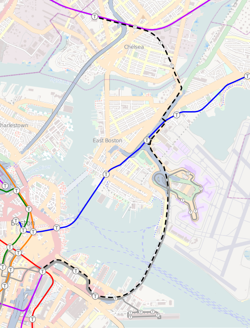
Because the Eastern RR's terminal used to be on the docks in Eastie, then passengers had to take the ferry. This was back mid-19th century when all the present-day commuter rail lines were independent competing railroads that all had separate downtown terminals with no such thing as a North Station or South Station union terminal.

The connecting track between Somerville and Chelsea was originally built as the eastern half of the Grand Junction RR by Boston & Albany so it could reach the docks in Eastie and Everett and interchange with the Eastern RR. Way back in the 1840's just a few years after B&A built the Worcester Line. Here's the original, complete GJ route: http://en.wikipedia.org/wiki/File:Grand_Junction_Railroad_and_Depot_Company_map.png. This is why it's got similarly sharp curves and shitty congested grade crossings just like the Grand Junction in Cambridge...while the original north-south Eastern Route is nice, straight, efficient,and mostly crossing-free.

When downtown union stations became preferable to the ferry near turn-of-century, Boston & Albany leased that Chelsea half of the Grand Junction out for Eastern Route passenger. B&A kept 2 tracks for itself (the ones the busway would go on) for freight. And Boston & Maine (which bought the Eastern RR) got 2 tracks for itself. And it stayed that way until the RR bridge next to the Chelsea St. Bridge came down in the 50's and B&A stopped serving Eastie. This is why today both Pan Am and CSX share Everett Terminal. CSX is inheritor of all the Grand Junction rights held since Day 1 by B&A over 160 years ago.


Because there were 2 co-tenants for majority of a century who had to agree on things there, that's why no attention was put into grade separation of those awful crossings at a time when the rest of the RR mainlines were getting aggressive crossing elimination near Metro Boston. Here it wasn't worth two arch-rivals haggling over who splits what cost.
 
Re: Silver Line to Chelsea (Study Meeting)

All I know is I'm miserable every time I have to take the train out of North Station and we don't move more than 5 mph for the first twenty minutes!

Thanks for the above. This extension should help stimulate residential housing growth up that way. The people moving into the big apartment complex just the other side of Route 1 will be happy. Well, in two years.

Speed used to be 60 MPH coming off the old Mystic River drawbridge through Chelsea until the restrictions got slapped down on all the crossings during the (mid-80's?). Sometime after the bad crossing accident that happened there. Eastern Ave. is the worse of the two because of the poorer sightlines, lots of gas tanker traffic on that street, and a 4-lane road so wide it's easy for daredevils to evade the gates. And that's the one where the trains could be picking up good speed coming out of Chelsea station, so it's a bigger penalty on the schedules.

Everett Ave. sucks less for train safety than for car safety, car congestion, and the hapless 112 bus riders who get caught up in the congestion. You can see with the recent installations of quad gates and the plastic dividers in the middle of the road the safety paranoia at work there with the traffic loads. The road backs up, and it's way too easy for a car to get stuck on the tracks in a traffic jam when the gates come down. The trains go slow because they have be able to have stopping distance either way on the 2nd Ave. to 6th/Arlington straightaway to see a stuck car from a quarter- to half-mile away. This is why a staffed crossing is unavoidable if the station moves there and busway comes. It passed the threshold of 'nightmare' years ago, and now with this project is sitting on the verge of 'carpocalypse'.

2nd Ave., 3rd Ave., Spruce, and 6th/Arlington are pretty negligible crossings. They could outright close 3rd because it's a low-traffic side street and de facto back driveway with easy access to 2nd Ave. from both sides. Peter Pan Bus might bitch about it because their bus storage yard is right next to the crossing, but that one can go. Spruce they'd want to eliminate if real-deal Urban Ring is coming, but it's not necessary with the Silver Line. 6th/Arlington is impossible to eliminate because of Route 1 overhead and underground waterways in the area preventing sinking the tracks, but that's the crossing of least concern street traffic-wise.


If they zapped Everett crossing it solves all the traffic issues and makes the relocated station net-positive for flow. You'd still be slow going into that station because there's not much acceleration room coming off that steep Mystic Bridge. But if they did something to Eastern Ave. to ease those restrictions all trains would be able to work up a considerably bigger head of steam going outbound from New Chelsea. Even if "something" is not grade separation but adding quad gates, obstruction warning sensors, retractable barriers, etc. like they do on the NEC in Connecticut to make paranoia-sure no Darwin Nominee gas tanker driver is gonna blow up half the city trying to outrun the train.
 
Re: Silver Line to Chelsea (Study Meeting)

Wikipedia hasn't been updated since September but this is the route proposed then.


Oh yeah, that map is mine. Just uploaded a new version; I'll add it to the article when I get a few hours to rewrite some sections.

500px-Silver_Line_Chelsea_proposal_map.svg.png
 
Re: Silver Line to Chelsea (Study Meeting)

All I know is I'm miserable every time I have to take the train out of North Station and we don't move more than 5 mph for the first twenty minutes!

Thanks for the above. This extension should help stimulate residential housing growth up that way. The people moving into the big apartment complex just the other side of Route 1 will be happy. Well, in two years.

I'm sorry to derail this further with railroad questions, but there was supposed to be a dedicated track out of North Station towards the eastern route, its the rusty one furthest east. It looks like it just has to be tied in to the mainline near community college, anyone *cough* f-line *cough* know why that never happened?
 
Re: Silver Line to Chelsea (Study Meeting)

I'm sorry to derail this further with railroad questions, but there was supposed to be a dedicated track out of North Station towards the eastern route, its the rusty one furthest east. It looks like it just has to be tied in to the mainline near community college, anyone *cough* f-line *cough* know why that never happened?

Not sure which one you mean. You have the Boston Sand & Gravel freight track spanning between the drawbridge and the side of Boston Engine Terminal below the Leverett Connector ramp. That's the one by Community College. It's chock full of freight cars end-to-end when the economy's good. Then you have the turnout for the currently unused Mystic Wharf Branch to Moran Terminal that turns out under 93 in the vicinity of the big billboard and Innerbelt ghost ramps. Massport wants to reactivate that someday for port freight. Then you have the Sullivan squeeze after the Orange Line viaduct touches down at-grade and everything stuffs underneath 93. The rusty freight tracks on the west side of Sullivan are the ones that went to the old freight yard at Assembly, which are just extra storage today and Urban Ring ROW in the future. They aren't tied in to any mainline...they come off the wye track from the tiny Innerbelt freight yard or off of BET.


Then where Haverhill/Reading and Eastern Route split the ER is back to 2 tracks and the Western Route is the one that peels off on a single. No issues there. There's a little storage siding after the split that's on the pre-1988 alignment to the demolished Mystic drawbridge, but that's purely a vestigial organ.


The terminal district is under-capacity. That's fine. It's strictly the Sullivan squeeze tucked under 93 that makes you have to choose wisely on load-balancing Western Route and Eastern Route.
 
Re: Silver Line to Chelsea (Study Meeting)

Trace the furthest east track off the drawbridge, it dead ends right before the storrow drive loop ramps at a pile of ties (I thought it made it all the way to community college). The whole thing is out of service from the first switch after it crosses the bridge. IIRC it was supposed to tie in to the eastern route further up and allow trains to pull full blast out of north station, or bypass tower A, or something to speed up travel throug there. This was years ago, so my memory is a bit foggy (or smokey truth be told)

OK, I see it. That doesn't have anything to do with one particular line as the interlocking it would tie into at that spot allows movement anywhere-to-anywhere. If the Eastern Route were to be the primary user it would only be because the track assignments get redistributed around west-to-east for cleanliness, not because any big service change forced the issue. The terminal district being under-capacity and NS Tracks 11 & 12 never being put in service leaves almost zero urgency to finish that job until they've got some free time on their hands to give some track crew a little extra credit project.
 
Re: Silver Line to Chelsea (Study Meeting)

The grade crossing accident that resulted in speed restrictions in Chelsea was 1966, accident report is here:

http://ntl1.specialcollection.net/s...\DOT_56GB\Railroad\WEBSEARCH\RAR-12-28-66.pdf

Also, the Wikipedia entry for the Grand Junction is very detailed, with a lot of info from the book "The Rail Lines of Southern Ne England" by Ronald Karr, a really great book
http://en.wikipedia.org/wiki/Grand_Junction_Railroad

The East Boston segment opened in 1847, the Eastern Railroad leased it in 1852 to build their Boston access route in 1854 as noted, and the section of the line connecting to the Boston & Worcester in Allston dates to 1856. The Boston & Albany did not take over the Grand Junction until 1869, after 13 years of litigation.
 
Last edited:
Re: Silver Line to Chelsea (Study Meeting)

On your original map, what were the green / red / orange dotted lines?
 
Re: Silver Line to Chelsea (Study Meeting)

I live a block from where the old eastern route tunneled under jeffries point to get to the wharves. The land is still vacant on the surface, which i assume is because there's crazy 19th century tunnel construction underneath and no clear legal standing for who would be responsible to fix it so it can be built on.

Anyone have a read on this? The southern portal is completely overgrown, but it will be somewhat visible once the foliage goes away for the winter. Has this tunnel been filled? Or just walled in?

That was the Boston, Revere Beach & Lynn railroad that the Blue Line now occupies from Logan to Wonderland. Narrow-gauge trains for most of its history so that tunnel was built tiny.


The Eastern Route still exists as the out-of-service East Boston Branch from Route 145 in Revere down to the self-storage warehouse sandwiched between 1A and Chelsea St. by the bridge. The new Eastie Haul Road being built from Chelsea St. to Bennington St. that the Silver Line will co-use is part of that ROW, which spread wide into a train yard there. 1A was built on stilts there on air rights over the train yard; all the parking lots underneath it today are landfilled up to street level on top of what was the below street-level yard. The Grand Junction Branch used to merge into that yard on a movable rail bridge immediately next to the Chelsea St. Bridge. Then the line continued down what's now the East Boston Greenway trail to the docks. The rail is still there on the former loading docks. The much longer-abandoned docks for the BRB&L are the next one over down the street. That's how close the two competing lines ran.

BRB&L was kaput by the end of the Depression. The MTA bought the ROW from Logan to Lynn in '40 or '42 as a long-term hold for the Blue Line extension. Eastern Route to the docks lasted until the (mid-70's?). The yard underneath 1A was active till the early-60's for Boston & Maine freight. The Grand Junction bridge was demolished in the 50's and ended Boston & Albany's co-use to Eastie. And the East Boston Branch was mothballed '90-93 threreabouts, although it is not abandoned and can be (and within the last year almost was) reactivated on several months' notice if Pan Am happens to bag a new customer.


Tunnel's in baaaaaad shape. Too dangerous to even give official tours. I suppose theoretically it could be made into a bike path, but it's got too many structural issues to sink lots of $$$ into with the Greenway barely 3 blocks away and almost totally grade-separated.

Yes...the Haul Road cut is wide enough to handle road + rail should Urban Ring ever go that mode. It was as wide as the Track 61 + Southie Haul cut and had embankment fill dumped into it to stabilize the ex- retaining walls after the freight yard went away and the ROW was shrunk to 1 track. They can scoop it back to original width with new retaining walls and shuffle the road over a few feet to the walls when it's time. UR Phase III intends to do this.
 
Last edited:
Re: Silver Line to Chelsea (Study Meeting)

The colored lines in the old wikipedia map were the alternatitives to the full build.


Tunnel's in baaaaaad shape. Too dangerous to even give official tours. I suppose theoretically it could be made into a bike path, but it's got too many structural issues to sink lots of $$$ into with the Greenway barely 3 blocks away and almost totally grade-separated.

Do you have a source, I've always been fasinated by the tunnel. The last I heard it was walled up because of tem durned kids, but aside from water was allright. There are pictures online somewhere I think. Then again its pretty useless for anything, so it doesn't really matter either way. Its amazing that the BRB&L blew the money for it in the first place.
 
Re: Silver Line to Chelsea (Study Meeting)

The Eastern Route still exists as the out-of-service East Boston Branch from Route 145 in Revere down to the self-storage warehouse sandwiched between 1A and Chelsea St. by the bridge. The new Eastie Haul Road being built from Chelsea St. to Bennington St. that the Silver Line will co-use is part of that ROW, which spread wide into a train yard there. 1A was built on stilts there on air rights over the train yard; all the parking lots underneath it today are landfilled up to street level on top of what was the below street-level yard. The Grand Junction Branch used to merge into that yard on a movable rail bridge immediately next to the Chelsea St. Bridge. Then the line continued down what's now the East Boston Greenway trail to the docks. The rail is still there on the former loading docks. The much longer-abandoned docks for the BRB&L are the next one over down the street. That's how close the two competing lines ran.

BRB&L was kaput by the end of the Depression. The MTA bought the ROW from Logan to Lynn in '40 or '42 as a long-term hold for the Blue Line extension. Eastern Route to the docks lasted until the (mid-70's?). The yard underneath 1A was active till the early-60's for Boston & Maine freight. The Grand Junction bridge was demolished in the 50's and ended Boston & Albany's co-use to Eastie. And the East Boston Branch was mothballed '90-93 threreabouts, although it is not abandoned and can be (and within the last year almost was) reactivated on several months' notice if Pan Am happens to bag a new customer.

.

The old yard in East Boston which is now the Breman St. park was a Boston & Albany (New York Central) yard, not Boston and Maine. When the bridge failed in the 1950s, the New York Central got trackage rights to use the B&M's Eastern route and the East Boston branch to continue to serve their East Boston customers which also included all the way to the docks. The present East Boston YMCA in fact reuses the old New York Central locomotive shop building. Penn Central and even Conrail both retained these rights. Conrail still had one customer up to the early 1990s, th Mobil facility off of Chelsea St. in East Boston used to see an occasional tank car, and it was delivered by Conrail, even though the spur was located only a short-distance away from the end of the B&M East Boston branch. Another Conrail customer in East Boston was the MBTA. When the (now retired) 1978-80 built Blue Line cars were delivered, they came all the way down from Canada on their own wheels, coupled to special spacer cars that let them be coupled to the end of a conventional freight train. Even though most of their journey was over the B&M (the line from Concord NH to Montreal was still intact at that point), it was Conrail that handled the final delivery to the MBTA at a special spur built under 1A to reach the Blue Line tracks. I can't find any photos on line, but I have seen photos of a Conrail switcher pushing a Blue Line pair over the spur

Speaking of the Blue Line, the MTA in 1948 (the MTA didn't exist yet in 1942) only purchased the BRB&L right of way from just north of Day Sq. to Revere St. in Revere. To this day, the MBTA only owns it that far as well. The stretch in Revere beyond Revere St. through Point of Pines was purchased by Massachusetts Electric for utility lines and to this day, the easiest way to follow the old right-of-way is to follow the utility poles. General Electric bought part of the right-of-way in Lynn, and part of it there also became a public street.

Getting back to the Grand Junction and Silver Line Gateway, Massport did a lot of work to enforce the crumbling retaining walls near Day Sq. when they built the present haul road that opened recently. I believe MassDOT/MBTA was interested in the possibility of a Silver Line Gateway stop in East Boston near Bennington St/Day Sq., but determined it would be too expensive to widen the right-of-way under 1A (plus the stop would be very close to the Airport station stop)
 
Re: Silver Line to Chelsea (Study Meeting)

Thanks guys - awesome material. What if we were less interested in reopening the tunnel than in building in the vacant lots on top of it?

Is there any precedent for who would be responsible for remediation? Would it take more than just packing the void with soil (i expect the answer is yes)

Is there some corporate decedent of the railway that would be on the hook? Is it the state? The person who owns the land on the 'surface'?
 
Re: Silver Line to Chelsea (Study Meeting)

The colored lines in the old wikipedia map were the alternatitives to the full build.


Do you have a source, I've always been fasinated by the tunnel. The last I heard it was walled up because of tem durned kids, but aside from water was allright. There are pictures online somewhere I think. Then again its pretty useless for anything, so it doesn't really matter either way. Its amazing that the BRB&L blew the money for it in the first place.

There's no Wikipedia article that I can find, but lots of pics if you Google Image search or check NERail. There were a few tours done for a few people. Most of the good pics were taken by the late Paul Joyce of the BSRA. It's very treacherous inside. Even some of the people who got the tour weren't sure that was such a wise decision, per Paul's recounting of the tour on RR.net. Muck, standing water, trash, places to fall down and break your face, claustrophobic. It would be a rather costly project to try to refurbish it and make it safe. And there's zero motivation to do it in a dank tunnel when the very pleasant, grade-separated, wider, and open-air Greenway on the ex-Eastern Route is right down the street.

2002112115121930521.jpg
 
Re: Silver Line to Chelsea (Study Meeting)

Getting back to the Grand Junction and Silver Line Gateway, Massport did a lot of work to enforce the crumbling retaining walls near Day Sq. when they built the present haul road that opened recently. I believe MassDOT/MBTA was interested in the possibility of a Silver Line Gateway stop in East Boston near Bennington St/Day Sq., but determined it would be too expensive to widen the right-of-way under 1A (plus the stop would be very close to the Airport station stop)

Bennington and Saratoga bridges. Bennington is a 1980 replacement span, Saratoga a '72 replacement. Google Maps shows trace evidence that the old bridges they replaced were once wider and that the new spans narrowed the ROW to the landfilled embankment. Were they to plunk a station in there, or were they to do Urban Ring LRT it in the future, both those bridges would have to be replaced. And that's not worth it for this when Washington St. is the big one that's going to suck up the $$$ being replaced or modified. The MassDOT alternatives show the busway having to pinch to a one-way underneath + stop signals for passing in order to fit underneath Washington, unless the redo the abutments.
 
Re: Silver Line to Chelsea (Study Meeting)

Thanks guys - awesome material. What if we were less interested in reopening the tunnel than in building in the vacant lots on top of it?

Is there any precedent for who would be responsible for remediation? Would it take more than just packing the void with soil (i expect the answer is yes)

Is there some corporate decedent of the railway that would be on the hook? Is it the state? The person who owns the land on the 'surface'?

Interesting question. I think you might have to "daylight" the tunnels (excavate them,open them up) in order to fill in the land and build on the property, not just fill in the tunnel and then build on top. The railroad did own the plots of land the tunnel goes under per old maps. The MBTA's predecessor (the MTA) did not buy that part of the line in the 1940s, so the MBTA does not own the tunnel or the land on top. I think the trust set up by creditors to dispose of the assets in the 1940s must be long, long, long gone. If I remember correctly, when the eastern portals were sealed up in the 1980s, it was the city that took on the responsibility of that as a public safety issue.
 
Re: Silver Line to Chelsea (Study Meeting)

The MassDOT alternatives show the busway having to pinch to a one-way underneath + stop signals for passing in order to fit underneath Washington, unless the redo the abutments.

I believe MassDOT does plan to redo the abutments as part of the already planned replacement of the bridge. If the commuter rail station isn't moved and is still rebuilt for full access at the existing location, 800 foot long high-platforms would have to continue under Washington Ave. and would not allow space for two bus lanes. The full modified package they are now proposing (moving the station, changing the bridge reconstruction plans) will allow for two lanes for the buses.
 
Re: Silver Line to Chelsea (Study Meeting)

Interesting question. I think you might have to "daylight" the tunnels (excavate them,open them up) in order to fill in the land and build on the property, not just fill in the tunnel and then build on top. The railroad did own the plots of land the tunnel goes under per old maps. The MBTA's predecessor (the MTA) did not buy that part of the line in the 1940s, so the MBTA does not own the tunnel or the land on top. I think the trust set up by creditors to dispose of the assets in the 1940s must be long, long, long gone. If I remember correctly, when the eastern portals were sealed up in the 1980s, it was the city that took on the responsibility of that as a public safety issue.

Yup, I just went to check it out this morning, the southern portal is bricked up (and fenced in) and I couldn't find the northern portal without some major daytime trespassing.

drbBA5U.jpg
 

Back
Top