Stuart Street Planning Study | Back Bay

shiz02130

Active Member
Joined
May 25, 2006
Messages
140
Reaction score
0
This topic was mentioned previously in the Columbus Center thread, but instead of bringing that thread off-topic, I thought I'd start a new one. You can find a PDF about the RFP for the study here:

http://www.cityofboston.gov/bra/pdf/rfps/StuartStPlanningStudyRFP.pdf

And here is the image from the PDF, showing the boundaries of the area included in the study:

stuart-street-planning.JPG


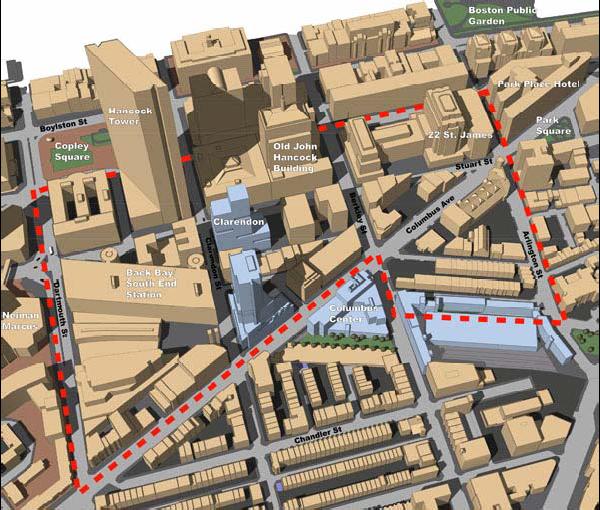
This purpose of the study is to "examine potential development opportunities, identify and define height, density, and use guidelines, and develop scenarios for future development in the area. The study will integrate 3-D computer modeling of the area to evaluate impacts."

This is by no means a blighted area, so there really aren't that many vacant lots or buildings crying out for redevelopment...

Vacant/Parking Lots:

-Parking lot next to Salvation Army on Columbus Ave. near Berkeley.
-Parking lot on the corner of Columbus and Berkeley.
-Parking lot on Arlington next to the "castle."
-Parking lot on Columbus next to the fire station.
-Parking lots on either side of 22 St. James.
-Small lot on the corner of Arlington St and Cortes St.

Buildings with redevelopment potential:

-Back Bay garage / Back Bay station itself
-The fire station on Columbus
-Maybe the Salvation Army building
-This crappy little building on Arlington Street across from the parking lot, which is technically in the Bay Village.

Projects that are already planned or under construction in this area (other than the ones already shown in the image):

-"The Bryant" - 301-319 Columbus Avenue
-The Red Cross building on the corner of Columbus and Clarendon; being rehabbed into lofts or something.

I think the only place where you might see significant height would be on the parking lot next to the Salvation Army.
 
Where is the fire station on that map?

The parking lots are shaded black? If so, the one on Arlington Street next to the castle looks pretty large; the rest are tiny infill lots.
 
We study things to death in this city... and yet nothing ever ends up happening within the guidelines and proposals of the study. The long heralded 'Civic Vision for Turnpike Air Rights", already covering several parcels of this study, is certainly a joke at this point.

The minute someone proposes anything, Shirley Kressel will be waiting in the wings, amassing villagers with pitchfork and torches. Or the BRA(Menino) just throws the suggested guidelines out the window because they do or don't personally like the developer.
 
Fire station

Ron, the fire station is near where Berkeley and Columbus streets intersect ... to the right of it, on the photo, on a triangular piece of land (the other road is Isabella).

They should force Winn to buy up all the homes on St Charles and Cazenove streets, since they're sinking into the ground, anyway.

And, Shiz, it's funny you should mention the Salvation Army building - I was running by there not two hours ago and thought, they should turn this into condos or a mixed-use building.
 
Another thing ...

Oh, another thing. I thought they were going to extend the Silver Line so that it came out of the ground right there on Columbus.

Will that be part of the planning study? Ha ha.
 
It would make a hell of a lot more sense to build the Stuart St subway they planned back in the 1940's and connect that with South Station. That would deal with traffic and NOT add lumbering busses onto the over crowded streets.
 
development

The Salvation Army talked about selling their site to a developer before. They would either relocate or be part of the new development. The T also talked about developing Back Bay Station. The parking lots won't last long after the other sites are gone.
 
czsz said:

Quickly, when the Huntington Ave subway was constructed the original plan was to build a much larger subway from the abandoned section under Tremont St, then it would hook under Stuart St with 2 stations and then it would travel under Huntington Ave, all the way to Brigham Circle (this is almost 20 years before the Riverside line was built).
 
So ...

That's cool about the Green Line extension down Stuart.

Can we just add a tunnel from the E Line stop at Prudential to the Orange Line stop at Back Bay / South End?

'k, thanks.
 
That'd be a half mile walk underground under/over/through a major highway. How about making it from Copley stop which is much much closer
 
You can already walk entirely indoors between the Prudential and Back Bay stations.
 
Re: Fire station

JimboJones said:
They should force Winn to buy up all the homes on St Charles and Cazenove streets, since they're sinking into the ground, anyway.


Is this a joke?

This statement is an example of how NIMBY's impacted the Columbus Center project. Adding a groundwater mitigation system for the neighborhood (even though the construction of these building have little effect on ground water) and forcing them to include parcels 18 and 19 wasn't enough already?
 
I'm glad to hear that. After reading the other thread and the comments about people selling there homes, I wasn't sure.
 
STUART STREET PLANNING STUDY PUBLIC MEETING
SEP 21, 2015
6:00 PM - 8:00 PM

YWCA Boston
Kuumba Library, 2nd Floor
140 Clarendon Street, Boston, MA 02116
http://www.bostonredevelopmentautho...1/stuart-street-planning-study-public-meeting

The BRA is now looking to adopt the recommended development review guidelines and codify them into zoning. At this meeting, BRA Planning Department staff will present the proposed development review guidelines and outline the zoning process that lies ahead. The guidelines being presented on September 21, 2015 will be the same as what was presented at the last Stuart Street Advisory Group meeting on January 6, 2011

Source:http://www.bostonredevelopmentautho...1/stuart-street-planning-study-public-meeting


Jan 6, 2011 revised presentation:
http://www.bostonredevelopmentauthority.org/getattachment/48bd82d8-4ec1-4aa3-b624-0567b895b574
 
I can't help but think the purpose of these studies is to blackmail developers down the road. I'm guessing the city pays for this? What a joke. The development should be more free market than pointless guidelines that will be broken down the road anyway
 
If Boston is going to have that true "high spine" then this is where a lot of that development should be happening. There shouldn't be an artificial zoning limit here beyond the FAA's. It's always been my belief that Stuart Street has some of the most developable plots left in the heart of the city! One of the few spots in Boston that makes sense to build towers to rival the Hancock and Pru.
 
Well throw that thought out the window after theyre done with their little study
 
I guess I am not as pessimistic about these efforts.

The Harrison-Albany Planning effort definitely opened up taller development in that area (not super tall, but much taller than the South End in general. The DEVELOPERS are the ones being cautious there! (So much for "market forces".)
 

Back
Top