The Official archBoston New Development Google Map

vanshnookenraggen

Moderator
Staff member
Joined
May 25, 2006
Messages
6,965
Reaction score
1,586
map_main.png


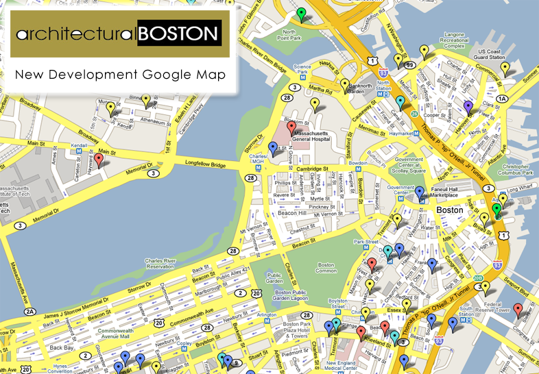
Here it is, the Official archBoston New Development Google Map. On it is every thread linked to the exact development site, color coded to denote which type of development it is.

key-1.png


Unfortunately I cannot embed the map into a post but I can link to it.
New Development - Google Maps

You can also download the map and view it in Google Earth.
New Development - Google Earth

Every time there is a new development thread I will add it to the map and these links will automatically direct you to the most up to date map (you will, however, have to re-download the map if you want to see it in Google Earth. I am leaving this thread open so if anyone has any suggestions or spots a mistake, they can bring it up. I will list any changes in this post.

Enjoy.

-Van

Updates
- Brookline Developments
- Modern Theatre
- Marriott Long Wharf
- Shreve, Crump & Low Building

- Added Avenir
- Added Mass College of Pharmacy
- Added Neponset Landing
- Removed Dedham Annexation
- Removed Residences at Kensington

- Added Seaport Sq, Constellation Center
- Added Spaulding Rehab Hospital

Future Plans
- Add an image/rendering of each building
- Add brief summary of each project
 
You need to add the new Spaulding Rehabilitation Hospital to be re-located to the tip of the Navy Yard.
 
Spectacular effort! Thanks, van.
 
this was on the Boston Real Estate blog. com www.Bostonreb.com click on new developments and projects

Cool Google Maps mashup - all Boston developments, with comments

So, one of the best local websites about local developments, existing, new, and under construction, is the Architectural Boston forum, here. There, you can read all about Boston architecture and design. I read it, religiously. (There?s also good coverage of architecture and design throughout New England, the US, and world.)

One of the regular posters to the forum, Andrew Lynch, has created an awesome map of all the local developments. It can be found, here.

You can see each new development, plus follow it back to the Architectural Boston forum, to see what everyone thinks.

If you have an opinion on a project, or know something interesting about it, I strongly suggest creating your own forum account and getting involved!

More posts about: architecture and design, new developments and projects


So congrats to KZ, vanshnookenraggen and everyone else
 
I join the praise. How often does Google update its satelite images? The one they have is over a year old, with ICA half-covered and the hotel by Manulife still in the ground.

justin
 
justin said:
I join the praise. How often does Google update its satelite images? The one they have is over a year old, with ICA half-covered and the hotel by Manulife still in the ground.

justin

I'd say they're even older than that. The elevated highway is still there, and has cars traveling on it.
 
The downtown/Back Bay satellite image is from the summer of 2002 (33 Arch gives it away) while the yellow-brownish-hued surrounding image dates to roughly April of 2005 (this time Trilogy gives it away).

The newest aerials that exist are the gorgeous hi-res images Microsoft uses for Live. Those date to early 2006.

By the way, excellent job, Van.
 
That is great, van. Something like that would be good to have on the front page of this site.
 
This is awesome. 8)

One small nitpick. Could you please correct 'Commercial'. :) :wink:
 
kz1000ps said:
The downtown/Back Bay satellite image is from the summer of 2002 (33 Arch gives it away) while the yellow-brownish-hued surrounding image dates to roughly April of 2005 (this time Trilogy gives it away).

The newest aerials that exist are the gorgeous hi-res images Microsoft uses for Live. Those date to early 2006.

By the way, excellent job, Van.

Whens Cambridge from? Those images are actually aerial photographs, not satalite images.


Kenmore square also features the old bus canopy, but the elevated highway and old green line elevated are the most obvious give aways at the age of the picture
 
Couldn't find Constellation Center on here...have we given it up for (at least temporarily) dead?
 
Four-theatre facility proposed for Kendall Square. Three live stages and one room for movies, I think.
 
Ok, I added Seaport Sq but I don't see a thread for the Constellation Center.
 
I updated the map (see OP) and have started to add images for each marker.
 

Back
Top