Urban Mass Transit Systems Of North America

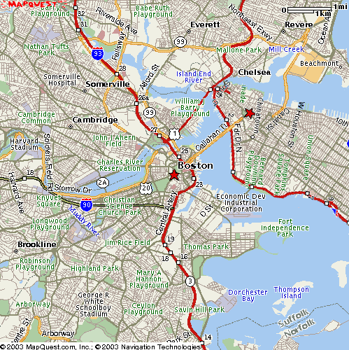
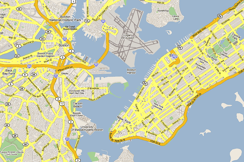
I know there are many tech savvy, cleaver people on this site who could easily superimpose Manhattan Island over a map of Boston to show just what Justin said. I know I'd love to see the comparison. Thanks.
 
Is this helpful?

2338911830_08fae8740e.jpg


Also this:

boston.gif


bos-map.gif


You can see Manhattan "floated" into position next to other cities here:

http://www.radicalcartography.net/manhattan.html

http://www.kottke.org/plus/manhattan-elsewhere/
 
Thanks so much czsz! Every time I visit Manhattan I try to visualize Boston's area..frankly, just in terms the main neighborhoods (North End, Financial District, Beacon Hill, Back Bay, South End, Seaport. I always knew that central Boston is tiny but seeing Manhattan Island alongside Boston...well, it's amazing how tiny Boston, in terms of land area, really is. However, tiny as she is, she's still a major player and powerhouse among US cities!
 
As my Big D and the Kids Table loving hardcore punk friends? t-shirts say?.

And I quote?

?This is BOSTON not L.A.?
 
Big kisses, I always wondered how NYC compared to Boston in area.

Where is the first map from - did you make it?
 
Last edited:
It's from none other than van's flickr stream.
 
So, New York City government is proposing turning 34th Street into a bus transitway.

Details from Streetsblog New York City. Click through to see the renderings and read the comments left by some really smart people.

DOT Plans to Bring NYC?s First Separated Busway to 34th Street
by Noah Kazis on March 2, 2010

When DOT Commissioner Janette Sadik-Khan hinted last Tuesday that bolder ideas were on the way for bus rapid transit in New York City, she apparently meant "next week." The DOT website now displays an updated plan for the next phase of bus improvements on 34th Street, which would convert the current bus lanes into a full-fledged transitway.

In addition to the features already found on New York's Select Bus Service, the 34th Street plan adds full separation from traffic, with two-way bus service operating on one side of the street. General traffic would travel one-way toward the Hudson River west of Sixth Avenue, and toward the East River east of Fifth Avenue. Between Fifth and Sixth, a new pedestrian plaza would be constructed in place of traffic lanes -- a configuration that Streetsblog readers may recall from a presentation in 2008.

All told, DOT projects that bus speeds will improve 35 percent, cutting river-to-river travel time to 20 minutes. Currently, buses on 34th Street are in motion only 40 percent of the time.

The placement of the transitway was selected specifically to enable pedestrian improvements. Running bus service in both directions along one side of the street allows for wider sidewalks and pedestrian refuge islands, according to an analysis of different options for the corridor [PDF]. Compatibility with loading and deliveries was also a make-or-break factor -- the configuration maintains curbside access to one side of the street along the entire route.

The new transitway would connect four subway stations, the busiest rail station in the nation, and the 34th Street ferry terminal. The M34 and M16 bus routes, which both run on 34th Street, carried more than 14,000 passengers per day in 2008. Several other bus routes use a portion of 34th Street.

In coming years, the corridor will get busier. The ARC tunnel will bring more New Jersey commuters into Penn Station. The 7 train will extend to 34th and Eleventh Avenue, and the development of Hudson Yards will bring thousands more residents to the west side. On the east side, the transitway would link up with Select Bus Service on First and Second Avenues.

The planning process is still in the early stages, and nothing is set in stone. Still to come: more detailed design, environmental review, gathering public input (which you can currently submit via the DOT website), and an analysis of necessary changes to the truck network. Planners hope to attract federal funding for the project. We have a request in with DOT for more information about what's next.
 
And whats wrong with having so many options?

And while the suburbs arent served well, Id say the RER system is better than our MBCR. I actually stayed in the suburbs, so I was 35 minutes out of the city, but the trains were frequent, and they have 24 hour service via coach style buses.

It's important to note, of course, that Paris sustains a density among it's entire metro area that is virtually unrivaled.
 
I think bostons rail system is actually very appropriate for the area it serves because it is very compact. Sure it could be better and eventually will but when it comes down to it its not as linear as most of the other rail systems which means it functions better by not just being a straight line in downtown with a few branches off it really goes out in all directions from downtown.
 
I think bostons rail system is actually very appropriate for the area it serves because it is very compact. Sure it could be better and eventually will but when it comes down to it its not as linear as most of the other rail systems which means it functions better by not just being a straight line in downtown with a few branches off it really goes out in all directions from downtown.

I think that's more because of Boston not being a gridded/planned city.
 
^ And it doesn't even include Hector Guimard's famous art nouveau Paris entrances! (what is the crap they've thrown up to represent Paris!?)

guimard_metro.jpg


Atlantic Cities sometimes digs up interesting stuff but there's way too much lazy traffic-generating bullshit. "Here people, here are some subway headhouses...at least the coolest few we found in a single Google Image Search..."
 
I'm going to add that in the SF Map.. BART should not be included. BART is more of a 'commuter rail', even though it uses subway-style equipment. Especially for the 'eBART' line which is shown.

But if you include BART and not the MBCR and the LIRR (and NYC's other commuter rail system).. it just doesnt make sense..

Just sayin..
 
Agree with the many reasons presented on why the map on page one is bullshit. What I think would e interesting, is a map showing all rail mass transit in the US scaled to the geography. So we would see, for example, a network of commuter rail systems in the North East connecting multiple rapid transit systems. The NE corridor would look like something, and pretty much nowhere else would.
 
BART runs on subway headways, so it counts as a subway in a way that commuter rails don't.
 
BART runs on subway headways, so it counts as a subway in a way that commuter rails don't.

Yup, BART should be included because it runs on a subway schedule, in the same way youd include DC metro and even the red lines braintree branch.
 
BART should be included, but CalTrain should not have been. Alternatively, other commuter rail lines should be added to the other cities' maps.
 
BART's headway outside of rush hour resembles commuter rail. You can wait almost 45 minutes to an hour for certain trains on certain lines. Plus that map includes San Jose as apart of San Francisco's transportation network. Yes, if this was the 'bay area' it would be correct, but last time I checked, San Jose wasn't apart of San Francisco. (then again one could say Braintree and Quincy aren't apart of Boston either!) I would understand if the LRV line in SJ went to SF but its confined to pretty much SJ proper.
 

Back
Top