BostonUrbEx
Senior Member
- Joined
- Mar 13, 2010
- Messages
- 4,340
- Reaction score
- 130
I find the southern portions of Saugus to be within reasonable distance of Boston to qualify for more density and better bus service, but as is now, the planning clearly sucks and everyone drives to everything, even down the street.
I decided to start with Cliftondale Sq, a stone's throw away from Revere, it seems to be the most sensible place to start; in my opinion it would be one of the easiest parts to redevelop and needs it the most. It has a small commercial base which is then surrounded almost entirely by single family homes with no market or convenience store all that close. The roads are clogged constantly with parked cars on both sides, which frankly this street cannot handle. Walking is treacherous from sunrise to sunset.
This is the area today: http://www.google.com/maps?ie=UTF8&ll=42.448735,-71.008549&spn=0.00232,0.005681&t=h&z=18
Here's what I have for Phase One:
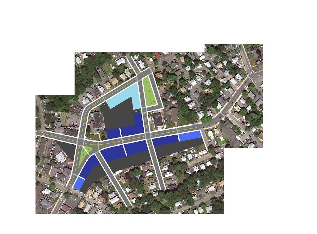
Phase One immediately sets the permanent street layout, reconfigures the circle to allow better traffic management and improve pedestrian options to a very significant degree, and sets the parking maximum. All parking in front of businesses is prohibited and there will be no more parking lots or on site parking outside of the designated parking lots or residential driveways.
Residences purchased and razed: 5 (5 single family homes)
Phase Two will improve the remaining commercial lots and will convert the pocket of houses on the dead end streets at the bottom into a few floors of apartments or something.
So, the zoning:
Dark Blue: Commercial/Mixed Use. Minimum 3 floors, maximum 4 floors. 1st floor must be retail. 2nd floor retail, office, doctor, or residential. 3rd-4th floors office, doctor or residential.
Medium Blue: Commercial. Minimum 2 floors, maximum 3 floors. 1st-2nd floor retail, office, or doctor. 3rd floor office or doctor.
Light Blue: Commercial. Maximum 2 floors. All floors retail, office, or doctor.
Emerald Green: High residential, no build in Phase One.
Lime Green: Medium residential, no build in Phase One.
Pastel Green: Low residential, no build in Phase One.
Light Olive: Park/Green Space
Beige: Plaza
Dark Gray: Parking, access, or otherwise paved.
This is mostly just blowing time with some fantasizing, but would it be worth it to toss it at the Saugus planning board or something (I have no idea how this town works)? At the very least I would like to see them get parking off the streets and follow through with changing the traffic circle as shown.
I decided to start with Cliftondale Sq, a stone's throw away from Revere, it seems to be the most sensible place to start; in my opinion it would be one of the easiest parts to redevelop and needs it the most. It has a small commercial base which is then surrounded almost entirely by single family homes with no market or convenience store all that close. The roads are clogged constantly with parked cars on both sides, which frankly this street cannot handle. Walking is treacherous from sunrise to sunset.
This is the area today: http://www.google.com/maps?ie=UTF8&ll=42.448735,-71.008549&spn=0.00232,0.005681&t=h&z=18
Here's what I have for Phase One:
Phase One immediately sets the permanent street layout, reconfigures the circle to allow better traffic management and improve pedestrian options to a very significant degree, and sets the parking maximum. All parking in front of businesses is prohibited and there will be no more parking lots or on site parking outside of the designated parking lots or residential driveways.
Residences purchased and razed: 5 (5 single family homes)
Phase Two will improve the remaining commercial lots and will convert the pocket of houses on the dead end streets at the bottom into a few floors of apartments or something.
So, the zoning:
Dark Blue: Commercial/Mixed Use. Minimum 3 floors, maximum 4 floors. 1st floor must be retail. 2nd floor retail, office, doctor, or residential. 3rd-4th floors office, doctor or residential.
Medium Blue: Commercial. Minimum 2 floors, maximum 3 floors. 1st-2nd floor retail, office, or doctor. 3rd floor office or doctor.
Light Blue: Commercial. Maximum 2 floors. All floors retail, office, or doctor.
Emerald Green: High residential, no build in Phase One.
Lime Green: Medium residential, no build in Phase One.
Pastel Green: Low residential, no build in Phase One.
Light Olive: Park/Green Space
Beige: Plaza
Dark Gray: Parking, access, or otherwise paved.
This is mostly just blowing time with some fantasizing, but would it be worth it to toss it at the Saugus planning board or something (I have no idea how this town works)? At the very least I would like to see them get parking off the streets and follow through with changing the traffic circle as shown.
