Crazy Transit Pitches

Urban Ring Phase II the way it should be

The T's half-assed Urban Ring plan never had a chance. The whole Phase II where the crosstown buses got upgraded to semi-real transit was a self-defeating half solution: drop a couple billion on subway tunnels through Longwood, yet run BRT through them. Do perfect grade separation in some parts, yet have the same bus slow to a crawl in mixed traffic on a different part of the line. And run this Frankensteinian creation end-to-end as if every rider's going to need the one-seat ride around the whole loop. And then at some indeterminate point later "fix the glitch" by redoing the grade separated parts with trains and building tens of $B's in tunnels through the rest.

Yeah...how did that work out? For one, not being able to do the Silver Line Phase III makes the southern mixed-traffic end impossible to cover in a single ride. For two, the billion-dollar Brookline tunnel crosses all 4 existing Green Line branches...an awful lot of existing infrastructure semi-duplicated by all-new infrastructure. For three, subways are hard to build in the 21st century under city streets with the spaghetti of undocumented utilities and abutting foundations...there's a reason why every single other transit proposal in the land requiring a dig (including the Big Dig itself) was burrowing under some sort of existing rail or previously cleared-out (e.g. elevated Artery) ROW. And finally, the whole half north of the Pike is already railroad...WTF are you doing wasting your time with this BRT crap???


Time to come up with a buildable plan you can actually 100% do for $3-4B without overruns. Behold, my UR Phase II Google map: a two-thirds Green Line, one-third Silver Line "compromise" that may not thrill Roxbury's and Southie's imagination...but covers the whole of the Phase II ROW, is very functional and reaches everything, and most importantly is eminently buildable with a little 20-year stick-toitive-ness where the T's diagram doodles were not. Map legend tells what all the color-coding means, and all the transfer stations are populated.

I classify it in terms of "hub" lines (ones that can pretty much go in circles one-seat and transfer you around the horn), "spoke" lines (stub branches that terminate at very major transfer stations), and a few "branches" branches that are obviously necessary but don't end at a transfer node like the spokes do. Only the ROW's and street routes are defined on the map, not the actual service patterns which can go a zillion different ways. Highlights:

GREEN LINE
  • North half on the Grand Junction, to the Airport, and on the Phase II stub to Harvard are built exactly on the alignment the T specced. But we do it right as light rail from Day 1. Because an interim BRT step is just facepalm-silly.
  • Instead of the billion-dollar Brookline tunnel, we extend the subway out from Kenmore to BU Bridge under the B reservation where it's easy to dig under an existing ROW vs. who-knows-what is lurking under Park Drive. Put a portal in that hobo colony park next to the Pike feeding the Grand Junction and Harvard, and the B spits back out on the surface by BU Student Village (and gets a WHOLE LOT faster with the subway replacing the BU school bus). Route the ring traffic to Kenmore.
  • Connect the D at Brookline Village with the E surface tracks at Huntington Ave. (should've been done long ago), and thru-route ring trains here from BU Bridge and Kenmore. Is the zigzag through Kenmore a little more roundabout than the billion-dollar tunnel? Yes. Do you want to get where you're going and see this thing built before your grandchildren are senior citizens? You'll happily put up with the extra 4-5 minutes on the zigzag. The T's own plan didn't even let you transfer at Kenmore.
  • Build that Harvard branch as specced with a new tunnel from the Stadium under the Charles, meeting up with the old abandoned Red Line tunnel in front of the JFK School. Recycle, re-use. We're such an efficient transit system.
  • Complete the jog from Union Sq. to Porter and Red/commuter rail. Probably should've been in the original Somerville extension plan all along, but it was pretty late in the game when they split it into two branches. Wouldn't be surprised at all if this gets built on its own in 10 years...STEP already advocates it as an add-on project.
  • Restore the E to Forest Hills and make Silver Line Washington streetcar like they both should've been all along. There's two critical "spokes", plus welcome re-use of that abandoned Tremont St. subway off Boylston for the Dudley ride. And you can actually make excellent time to Forest Hills from Kenmore, Harvard, Cambridge, and BU where you couldn't before.
  • Whither SL Phase III? Can't build it under city streets without costing $5B, but how do you tie in the South Boston Transitway to downtown? Well...we got that nifty North-South Rail Link thing that they also should've been building by now. And it's going to require building a half-mile long approach tunnel under the NEC to about Washington St. for Providence/Worcester trains to enter, which means there'll be some serious digging under the tracks. Hey, what if we joined forces and kill two birds with one stone by piggybacking an LRV tunnel next to and/or on top of the Link tunnel. That gets both built on the same footprint, brings you 1 block from the end of the Tremont tunnel now restored for Dudley, and solves the whole SL III boondoggle with a totally non-street dig. Wow, MBTA, look how intrepid and efficient you just were with that move!
  • Now that we've reached the Transitway, let's throw some tracks in that bumpy concrete and get more use out of the thing. You Silver Line buses can stay...the pavement's not going anywhere. But we're going to be so goddamn resource-efficient here we're gonna use the same tunnel, platforms, and wires for two whole modes. People will think the T won a Buy One Get One Free subway sweepstakes when the trolleys start rolling to the Convention Center. Oh, and you tourists coming from Logan can be as indecisive as you want on our transit system 'cause you'll have 4 consecutive dual-mode stations to hop between bus and trolley from the same platform when you're all confused about where you're going.
  • This is gonna get busy real fast. After we get the whole system up and running, let's get a second subway thru route to downtown going by extending the existing Huntington Ave. subway from Northeastern straight out to Brookline Village. We need to replace all that street track for these kinds of traffic levels. It'll be easy like the B subway out to Brigham Circle because it's just burying the existing reservation. And then you've got about 2000 feet of "hard" tunneling to do under Huntington the rest of the way. But notice that this is the only significant stretch of "hard" under-street tunneling we've had to do at all on the whole build. And this one won't top 9 figures unlike the scrapped SL Phase III or Brookline bore plans. Everything else we've dug under existing railbeds, and in case of the NEC tunnel we shared construction cost and labor with the equally critical N-S Link project. And if we run out of money we don't have to do this one right away...100% of the build routes can function over the existing track, just with tougher congestion.

SILVER LINE
  • Now that uncomfortable "compromise" part. Sorry, it's just too much money right now to build the south side of the ring. All tunneling we have to do here is the "really hard" under-street kind, and there aren't a whole lot of streets that can be fitted with trolley reservations. So we are gonna have to play King Solomon here and make this part of the ring BRT until we figure out how to make a realistic Phase III. We'll do bus lanes and signal priority and expensive-ass glass shelters on every street that'll fit 'em. It won't be that bad...you won't have schedules hosed by one bus making the whole circuit around town like the T's stupid Phase II plan. And there's SEVEN rail transfers (8 if you count South Station in the Transitway) to every line in the land not named Blue on this route. That's a pretty damn good deal on balance. And if you have to get to Cambridge you can do it in 1 transfer...I promise.
  • The 28X proposal...hey, that kind of works a lot better now that you've got trolleys going direct downtown to Dudley. Let's give Mattapan a spoke.
  • Oh, hell, make it two. You guys want to get to Forest Hills, too. Let's call this the Menino Line through Hizzoner's home Hyde Park.
  • Let's connect all these spokes together with a short shot from Forest Hills to Dudley. Ties the room nicely together. Like that elevated Orange Line used to.
  • City Point...you guys kinda got screwed over by your prior Silver Line experience. Now that there's more ring ridership coming out to the Waterfront, let's have a do-over with a stub branch that actually goes through the neighborhood this time instead of blowing past blighted industrial lots.
  • Something's missing in Cambridge. Let's knight the 77A trackless as its own "remote" SL spoke, and extend the wires up Mass Ave. to those new direct-to-Alewife busways the T plans to build. Ties the Cambridge nodes nicely together.
  • Since we've already got wires on Mass Ave. and have already got those dual-mode articulated buses from the Transitway, let's also make the full 77/79 to Arlington Heights a SL branch with a power switch on the 77 to diesel at Route 16 at the end of the wires. I know...an outlier for the whole ring concept, but it's efficient use of existing infrastructure and helps justify cost for more Airport dual-modes by being able to order in greater bulk. It's the only line in the system that can significantly add extra value to maintaining a dual-mode bus fleet for the system.


Note the map doesn't touch the B, C, D, or Somerville extension since it's an Urban Ring-centric map. I'm all for bringing back the A line to Oak Sq. or Watertown, spurring off the D to Needham Jct., taking the Union/Porter line to Watertown via the Watertown Branch RR, throwing tracks in the Ted and running battery-powered LRV's off-wire on the jog to Logan instead of SL buses, building elevated BRT+LRV loops at the Logan terminals so both the Airport spoke and Silver Line can go grade-separated to the terminals, and so on. Plus getting some of those easier-to-convert SL routes over to streetcar as fast as possible so the BRT phase is as short-lived as possible.

But whole point of this was to get the complete as-envisioned Urban Ring routing built at all with some kind of realism, fiscal responsibility, and commitment. It reinstates as rapid-transit or almost rapid-transit nearly every streetcar line in the ring zone that was still around as late as 1953. See here...the 7, 10, 29, 30A, 40, 42, 43, 79, and 82 on that map are all back in the system in some sort of close facsimile, plus the 1980's-era Arborway and El lines. I think this plan accomplishes what it sets out to do, and a whole lot more overall than the T's own unbuildable blueprints.
 
Cool map, lots of interesting ideas. I'm curious about the decision to make Forest Hills the intersect point between Orange Line and the Ring. It seems to me something less outlying would serve the purpose more effectively. Consider, for example, extending the E line down Heath St. to connect with the OL at Jackson Square. You could then follow a few different options for connecting with Dudley such as paralleling the OL, then turning the E along Malcom X Blvd. toward Dudley Square to connect with your eponymous F.
 
Cool map, lots of interesting ideas. I'm curious about the decision to make Forest Hills the intersect point between Orange Line and the Ring. It seems to me something less outlying would serve the purpose more effectively. Consider, for example, extending the E line down Heath St. to connect with the OL at Jackson Square. You could then follow a few different options for connecting with Dudley such as paralleling the OL, then turning the E along Malcom X Blvd. toward Dudley Square to connect with your eponymous F.

Forest Hills wouldn't be the only one...Roxbury Crossing on the Silver "hub" line between Dudley and Kenmore would also transfer to it on a straighter line. But FH itself is one of the biggest bus hubs in the system so that's a must-hit node. You'd be isolating Rozzie, West Rox, and Hyde Park from the ring system to exclude it, and the 39 is its own house of horrors needing help. Relocated Orange Line also didn't end up aligning well enough in practice with the north-south (S. Huntington/Centre/South) orientation of the neighborhood's commuting patterns to adequately serve the old Arborway trolley's ridership. There's a reason why this was a law-mandated restoration in the official Big Dig transit commitments agreement. Backing out of that was maybe the second-most shameful thing the T has done the last 25 years beyond sticking Roxbury with an "equal or better" bus replacement for the El.

Plus you tie two of the very biggest bus hubs--FH and Harvard--together with a one-seat ride via Kenmore + Brookline Village. That's a connection that's never been doable without an hour's worth of multiple transfers. Not very much street-running track to traverse if coming via Brookline Village, either. Even less so when/if you build out the Huntington tunnel all the way.


Definitely, along with the Dudley node and Comm Ave. subway, one of the first LRT pieces of the system that should be laid. The Dudley-FH Silver Line connection is semi-superfluous since nearly everyone's going to go to one or the other via rail and not between them. But, whatever, the 42 is already a short FH-Dudley shuttle running back and forth on Washington. Might as well class it up a bit with a bump onto the official ring spider map and the requisite stop + lane upgrades along Washington.
 
Currently working on another radical idea...

My personal FutureMBTA map featured a 10 mile radius of rapid transit spokes and urban rings around Boston. Now I'm tacking on a 5 mile radius of transit for Salem. I find Salem the best spot for a mini-me to Boston. It's a pretty swell small city, in my opinion. Also I find the density, geography, distance, etc quite appealing for what I'm proposing.

So the Blue Line would run all the way until about 5 miles north of downtown Salem (North Beverly Station if I do recall correctly). A Red Line from Danvers, through Peabody Sq, along the Blue Line under downtown Salem, and off to Marblehead. An Orange Line from where two old ROWs meet near the Rt1/I95 junction (with the intent that at max build out, it would follow on the branch through Lynnfield and meet the Orange Line in Wakefield (as the Orange Line would run to Reading)) to Peabody Sq, and the other end the Orange Line would hook it's way around downtown and down the old ROW to the coal plant, then hook towards Pickering Wharf. And then a Green Line which would run from the Lynnfield Tunnel on Rt 1 (and again, at max build out, down Rt 1 to connect with my FutureMBTA Green Line at Rt1&Rt99) and follow the Blue Line to Beverley Junction where it swoops over to hit Prides Crossing and Beverly Farms. In all, it maintains a general 5 mile radius of Salem, meshing with Boston's 10 mile radius, in an attempt to make a very large and dense urban area.


It's alot to take in, hopefully I'll finish up the map soon so ya'll have a visual. Once that's done, I'll consider it officially capped and put a completion date of 2150 on it, LOL. Then it's on to the Merrimac Valley Transportation Authority...
 
FINALLY! I can consider it: COMPLETE!

http://www.google.com/maps/ms?ie=UT...007,-71.064034&spn=0.148925,0.363579&t=h&z=12

Months of laying lines and making tweaks and I consider this to be pretty much my "final" draft of the future MBTA.
I'm more than two months late in answering, but I really like your map.

Especially the Blue Line extensions through Cambridge and Waltham (perhaps the Blue Line is better served as an S-bahn-style system).

I have some questions.

What do the numbered lines pertain to? LRT? BRT?

Is the Purple Line also heavy rail/metro?

And does the density around Arlington justify a Red Line extension?

All are heavy rail except the Yellow (Light Rail), Black (BRT), and Maroon (Mattappan High Speed Line).

However, as I have once again begun tinkering with the map, I've been considering the Orange, Green, and Blue lines being EMUs as they would be hauling all the way to Salem, I'd prefer they all be the same stock as they'd all be sharing trackage at some point, and for the sake of flexibility where ROWs must be tight but still shared with commuter rail. Essentially, I think EMUs would actually be cost saving with the ability to mix and mingle with other traffic due to the extent of my system.

I don't find it necessary for the Purple and Red lines though, although I'd like them to be of the same stock, too, and hopefully share a rail yard or two. Also, the Cyan Line would essentially just be today's Blue Line stock, but perhaps in sets of 4. I decided to tune it down so as not to compete with the "real" Blue Line but still continue service in the area.

This is not so much about present density as it is about future density or spurring future density. I think Arlington in the present day already warrants an extension, but not before a Blue Line to Lynn or anything like that of course.


The whole thing is kind of going under the knife, so expect I full follow up when I'm done! :p
 
http://maps.google.com/maps/ms?hl=e...18710954337134.000494ac61372e576bef4&t=h&z=11

Here's my dream heavy-rail subway system.

-- All lines extended to 128 in each direction except for Orange Line south.

-- Orange Line to Reading north per 1945 plan, replacing Reading commuter rail (Haverhill line goes back to Lowell Line + Wildcat Branch).
-- Orange Line extended south to West Roxbury per 1945 plan, but stops there. Dedham ROW unavailable and duplicated by Dedham Branch Red Line; Needham ROW duplicated by Blue Line Needham and would preclude having Millis commuter rail due to wetlands-unexpandable ROW.
-- Orange Line express track extended Wellington--Oak Grove per 1970's plan. Manages unidirectional rush hour traffic.

-- Blue Line extended north to Lynn along Boston, Revere Beach, & Lynn ROW (per the 1945 plan), then Salem along Eastern Route, then Peabody/Danvers along freight tracks (replaces proposed Peabody/Danvers commuter rail).
-- Blue Line extended west from Charles MGH tail tracks under Storrow Dr. to Kenmore, with Storrow demolished and BL recycling Storrow auto tunnel and continuing in shallow tunnel on Storrow eastbound grading. Esplanade restored on top.
-- Blue Line extended west from Kenmore on Green Line D line, replacing light rail.
-- Blue Line branched to Needham Heights using Green Line branch proposal.
-- Blue Line branched on Airport Loop from other Charles MGH tail track along Urban Ring ROW via BET and Eastern Route. Trains from west loop, trains from north loop to manage very long length and large number of stations. Also helps throttle down service to north suburbs and Needham well after hours.

-- Red Line extended to Hanscom via Lexington/Arlington (per 1970's plan), then to Burlington Mall via power line ROW.
-- Red Line extended to Mattapan, then Readville via River St. subway and Fairmount Line, then Dedham via Dedham Branch.
-- Indigo Line a new subway line using Red Line cars, using 2 tracks of North-South Rail Link, Broadway upper-level trolley tunnel. Replaces Green Line Medford and Fairmount Line, extended along NEC to Westwood/128. Runs parallel to Red Line on 4-track from Mattapan to Readville.
-- Red Line Cabot Yard lead tracks junction with Indigo Line before it hits Broadway portal, allowing interoperable routings from JFK/Columbia Jct. to Indigo Line.
-- Red Line + Indigo Line alt routings via junctions at Readville, JFK for any combination of branch and short-turn service patterns: Woburn--Braintree, Westwood--Alewife, Dedham--Route 16, etc.
-- Combination of alt routings on south branches and turnbacks at Alewife and Route 16 manage rush hour traffic, throttle-down traffic in north suburbs after-hours.
 
Perhaps we should consider the entire T as a version of the S-Bahn, or BART. Since it can be extended into the suburbs that are within the 128, it could count as some form of regional rail. If the North-South Rail Link is finally built and the MBTA Commuter Rail is transformed into a regional system, serving the areas in Greater Boston outside the 128 (Providence, Nashua, Worcester), would it be equivalent to the Paris RER, or more like a RegioBahn?
 
F-Line - I'd love to see an integrated map of your heavy rail ideal with what you've already described as your Green Line ideal... when you have time!
 
I don't think that'll fly. Google Maps gets waaaay unstable in my browser when it gets overloaded with stuff.

I do have a commuter rail map I'm almost finished with.
 
Create a branch of the Orange along the pike to at least fenway park/kenmore, station below a big parking garage above the pike that would have direct on/off ramps from the Pike and also include the much talked about U-Turn for the Pike.

Create another Stop on Red Line between Quincy Center and Quincy Adams stops.
 
http://maps.google.com/maps/ms?hl=&...0491618710954337134.0004a4e38985d9d185657&z=8

OK...here's the great Commuter Rail system map for when it's peak oil time, no one in the bottom 75% of income can afford to commute at $5.50/gal., and the "[insert President's name here] Interstate Railway System" gets funded to keep the nation's suburban economy from collapsing to dust.

Note this thing pushed Google Maps to its limits so some stuff spilled onto a second page, with the whole first page disappearing when you click next. Very annoying. A couple minimal-usage alt route lines--the Middleboro Secondary bypass to the Cape via Taunton/Middleboro, and the Attleboro Secondary Attleboro/Taunton...both used till 1996 by the Amtrak Cape Codder--spill awkwardly onto p.2. All the placemarkers also ended up on p.2, but those are easier to follow. I didn't even bother doing the last couple out-of-district lines like the Falmouth branch on the Cape or RIDOT Providence/Woonsocket because they'd look like nonsense with the rest of the map invisible.


Big-deal stuff:

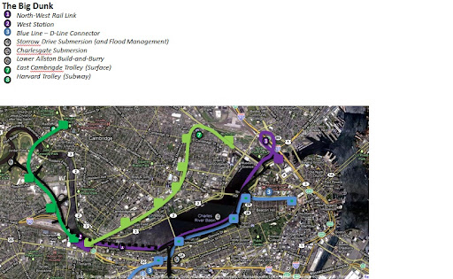
-- North-South Rail Link. Built the half-RR/half-rapid transit way I showed on my rapid transit map. Electrics or dual-mode trains can use the Link and pretty much all Amtrak trains will. All commuter rail trains terminate in Boston, with the real biggies running thru the Link (e.g. Worcester--North Station, Concord--South Station) to terminate and all the others staying where they are. It's not like there's a crying need to go from Franklin to Rockport. I cut the Old Colony Lines portal from the original design and left that "for future generations", since those lines aren't intercity with traffic levels worth spending a half-billion on and the Cape is already accessible from the Link from alt. routes. Greenbush and Plymouth will get over the decades of extra wait; they can transfer to Red Line Braintree, which has direct alt routes through the Link/Indigo Line.

-- Deleted lines replaced by rapid-transit (per my other map): Fairmount, Reading, Needham (north of Needham Jct.). Most inside-128 intermediate stops on the lines that now have rapid-transit on the same ROW are flipped over to the subway side so the intercity and CR lines are focused outside of 128 and just speed on through.

-- HSR lines: Providence, Worcester, Lowell/Concord, and Portland via the Eastern Route. Eastern Route/Newburyport Line is restored all the way back to Dover, NH (not depicted on the map) where it hooks back in to the Western Route for the rest of the Portland trip. I chose this over making the Haverhill Line/Western Route full-on HSR because the Eastern Route has long arrow-straight sections for max speeds, has only a couple serious clusters of grade crossings (Everett/Chelsea and Beverly) to eliminate vs. a constant stream of them, isn't clogged by heavy freight volume like the Pan Am mainline is, keeps the Lowell/Concord Line to Wilmington from getting overloaded with intercity traffic, and aligns better directionally with the Worcester Line for thru service (i.e. north-south Concord-Providence, west-northeast Worcester-Portsmouth). Haverhill/Western Route gets electrified and is much faster than it was, but still sub-HSR speed.

-- High-density rapid-transit like service: Worcester Line to Riverside, Fitchburg Line to 128. These are the two mainlines on the system that can't be paralleled by rapid-transit lines because there's not enough room. So I'm adding 128 short-turns at Riverside and Waltham Highlands, a bunch of infill stations (Newton Corner, Brighton, Allston, Alewife, Clematis Brook, etc.), a couple triple-track passing tracks so the CR and intercity trains can get around, adding electrification to Waltham Highlands (everything past that runs on diesel because of lower density and no intercity traffic), and really running the crap out of the inner-suburb headways to give some semblance of rapid-transit.

-- MBTA vs. out-of-district: Balancing act here as the MBTA needs to be focused on 128-to-495 (or closeby state lines) as its primary public service, but there's need for Boston regional service into NH and RI. Concord, Dover, and Portsmouth are all revived CR lines that lasted a little bit into the MBTA era mid-60's before going away (Concord briefly revived 1980-81). Sort of like how they used to run, T locals stop at the edge of the district and the interstate trains are subsidized by NH, continue on over the border with somewhat less frequent schedules, and express through all but the most important MA stops en route to Boston. Ditto RIDOT, where the Providence Line will overlap a bit in-state with their homegrown commuter rail to Westerly. Balances out the schedule-keeping and passenger loads, and expressing keeps total travel time reasonable on the longer interstate routes.

-- Cape and Newport out-of-district service: Fall River and Buzzards Bay are the practical outer extents of the MBTA district. However, RIDOT has tourist train tracks on Aquidneck Island it's expressed interest in spiffing up and restoring back onto the mainland to Fall River if South Coast Rail is built. Let RIDOT subsidize very limited (1 or 2 rush-hour runs morning/evening) commuter trains year-round, and then in summer ramp it up to a more robust in-season out-of-district schedule. Ditto the Cape, which can have its private seasonal tourist train transform into a "Cape Rail Authority". Mesh with the T at most 1-2 rush hour directs to Boston year-round, then ramp it up big in-season for a much more frequent schedule to Hyannis and Falmouth. Including transfers to RIDOT/Providence and a restored Amtrak Cape Codder from NYC.

-- Alternate/radial service: All of these trains are going to be a little difficult to schedule, so we want some rush hour backup. The Framingham Secondary and the Framingham-Leominster "Agricultural Branch" lines are a contiguous stretch of track that intersects 6 T mainlines on my map. Mix-and-match the service patterns to use this thing to the hilt and keep overloaded lines like Worcester or Franklin from having to feed extra branches they can't handle at rush.

-- Electrification. It only makes good financial sense with really heavy traffic volumes or 24/7 service. So electrify all the HSR and intercity routes: Providence, Worcester, Concord, Portsmouth, Dover. And electrify the inside-128 Fitchburg because we're compensating for no rapid-transit there. Leave the others all diesel except for maybe tacking on later short branches like Rockingham Park and Rockport that go a majority of their route miles over previously-electrified mains. Nothing else really has the frequencies to justify that huge an investment, and almost 2/3 of the system's traffic is on those electric trunk lines so a majority of your trains are electric anyway. Have a small fleet of dual-mode locomotives if there's need for a rush hour special into the N-S Link...they can power-switch to diesel when they branch off-wire.


Overview of other new extensions:

-- Small 1-2 stop extensions of Plymouth Line to Downtown Plymouth, Greenbush Line to Marshfield, Franklin/Forge Park to Milford. First two are where those lines were originally supposed to go in their recent restorations before the NIMBY's forced compromises, so we're just finishing the job. Milford's a longstanding CR proposal that just upgrades a few miles of freight track.

-- Salem, NH via Lawrence: We were so close to having service here inaugurated in 1981 that it got printed on the official T map, but then they had to back out at the last minute due to budget emergency. Upgrades the freight tracks to Methuen/Route 213 then pokes across the border to Rockingham Park on 1.5 miles of abandoned ROW to the racetrack lots for a big I-93 park-and-ride.

-- Millis/West Medway: Millis was a CR line till '67 and West Medway till '64. Now badly needed for road congestion, and studied proposal had very high projected ridership. Upgrade the active freight tracks from Needham Jct. to Millis (which junction the Framingham Secondary en route), then to West Medway on the abandoned ROW. Line historically intersected the Milford Line right past Forge Park, but there's subdivisions built over the ROW so it has to stop here. Use the line to feed the Framingham Secondary for rush hour relief of other lines.

-- Woonsocket via Franklin: RIDOT did an official studied proposal of extending the Franklin Line to Woonsocket 15 years ago. Uses the active freight tracks a mile past where the Forge Park trains peel off, then 2 miles of abandoned ROW, then an eroded causeway over Harris Pond at the state line in Bellingham. RIDOT would rebuild the causeway, MA would restore the 2 miles to Bellingham, and end of the line would junction with the P&W freight main in Woonsocket. Woonsocket then becomes a mini- regional rail hub because RIDOT also wants to run Providence/Woonsocket and eventually Providence/Worcester CR through this station via the P&W.

-- Central Mass Line: Old CR line that branched off the Fitchburg in Waltham and went to South Sudbury till '71 and Hudson till '64. T officially studied restoring it to West Berlin/495 in 1993. Crosses the active Leominster/Agricultural Branch in West Berlin, so would act as a south-flank Fitchburg Line for the increasingly brutal traffic the length of the Routes 20/62 corridors. Splits from Fitchburg at 128, so would bulk up the inner-suburb service where we want near- rapid transit headways.

-- Northboro/Leominster Line: On the active Agricultural Branch freight tracks from Framingham. Studied CR proposal. Northboro leg hits Framingham State U, Route 9, Pike, 495, Route 20, I-290 for string of park-and-rides Worcester Line doesn't reach. Can be fed express at rush hour from Framingham Secondary via West Medway line. Junctions with Central Mass Line at West Berlin and can alternate schedules with it for reaching Leominster, I-190, Route 12.


------------
I swear I haven't spent a whole 40-hour work week on these 3 transit maps! I've been farting around with them a few minutes a pop since early Nov., putting it down for weeks at a time while I had real work to do. I've found that if you push Google Maps to the point where the sheer number of map elements makes it unstable that you can wring more total elements out of it by saving your work when it hits a certain buggy overload...then import all your saved work wholesale into a brand new map...delete the old map...then continue piecemeal work on the imported new map. Rinse, repeat when you hit another instability wall. That's the only way my Green Line/Urban Ring map and MBCR maps ever survived to completion (and the CR map is still crippled by that @#$% page 2 bug)...the rapid-transit one was the only one that didn't get all crashy and unworkable on the original canvas.
 
Last edited:
F-Line - once you're in "edit map' mode you can choose to export to Google Earth. If you could host that resulting file somewhere then you can post a link. Google Earth has no limit (that I've found) in terms of added points or lines, and it has much better UI overall. Just a thought, since those missing points can be frustrating.
 
One thing the CR map doesn't address is per-project degree of difficulty. So here's the caveats. And obviously nobody's expecting this to get built in entirety so much as it's just the whole universe of buildable projects for a future when car commutes from 495-in get tougher to swing. All using rights of way that are either active or preserved for rail reactivation under the landbanking statute.


Expensive megaprojects
-- N-S Link: Probably heading to $6 bil by the time actually built, but utterly critical. I cut the Old Colony portal from the initial build to save significant money. No intercity service down there, so they'll get over having to wait 25 more years. Did the rapid-transit sharing because would help offset costs with much greater revenue. And cut the direct Fitchburg Line portal (not shown on map) in favor of slower roundabout loop around the yard into the main portal...cost savings, no intercity, few trains needing to run past North Station, so the slower maneuver into the Link is no big deal.

-- Eastern Route HSR: You're talking restoration of a lot of route miles in NH...not hard on the rural stretch to Portsmouth but complex on the denser Portsmouth/Dover leg. Plus a brand new Merrimack River bridge and widened Salem tunnel. Plus eliminating clusters of 7 grade crossings in Everett/Chelsea and 7 in Beverly. Plus electrification. Probably $1-2B when said and done. Too much cost to swallow until much later. Electrified Western Route--congestion, slower speed, and all--will have to suffice in the interim before the real-deal 150+ MPH route can be done.

-- Electrification: Will get ample federal assistance for the intercity trunk lines (Worcester, Concord, Haverhill/Dover). Plus Eastern Route when that's ready. State can probably swing Fitchburg Line-to-128 wires for the high-frequency service. But gotta compromise away having wires everywhere. It's not practical on non-intercity lines that don't run 24 hours a day and only have trains once an hour weekends and well off-peak. Maybe add much later on for the Rockingham Park and Rockport branches where they run more total route miles on already electric mainlines. N-S Link can only hold so much on 2 thru tracks and 4 underground platforms per station, so no need to go electric when most lines will still terminate where they do today. Note that more total trains on the T will still go electric because the trunk lines carry > 2/3 the system ridership. Maintain a small fleet of dual-mode locomotives that can send a few diesel lines into the Link as necessary, but don't go overboard with yet another new mode when diesel--20 years of increased fuel/emissions efficiency in the future--is good enough.


Problematic/dodgy extensions
-- Marshfield: There's one residential subdivision to snake around past Greenbush. Given all the NIMBY problems the current line had, a possible dealbreaker. Frankly, not that high an upside and not a big loss to scuttle.

-- Central Mass: By far the most route miles of abandoned/landbanked track to restore. 1993 restoration study had OK but not overwhelming ridership to West Berlin. Maybe better to build first to South Sudbury short-turn where Route 20 congestion is bad, then let demand crest and build the rest much later. This would be the first new line I'd cut as cost compromise.

-- Rockingham Park: The T stupidly gave Methuen permission this past month to lease a couple miles of seldom-used freight track to rip up for a gravel trail if they pass ultimate T approval of final plans and TBD funding. Idiotic because the line was active and will create an army of NIMBY's if they exercise the restoration clause in the lease. Plus the trail plan looks like barely-landscaped garbage uninviting to even to walk on. I think I-93/Route 213 relief merits bulldozing the opposition (hell, they thought this was a good idea 30 years ago!), but this is a new hurdle. NH has dreams of restoring the line all the way back to Derry/Hooksett/Manchester Airport where it's landbanked as (nicer) trail, but they're so tax-poor and chronically behind the political times on rail it's asking way too much. Poking across state line is it...if they didn't already murder it with the Methuen trail.

-- Millis/West Medway: Another trail lobby looking to take the active line from Dover to Medfield. Somewhat obnoxious group trying end-run tactics around the T with local pols to ram it through. Don't know if they'll succeed because they're under-resourced, but the guys leading the lobby are VERY aggressive. If the T lacks sufficient willpower to rebuff the noise this line could get blinked out of existence by the gravel trail and ensuing anti-restoration sentiment. Which would suck because ridership projections are higher than most almost any other extension and it intersects the Framingham Secondary at its midpoint for easy alt service to Worcester and Franklin Lines + Foxboro. I would even build Millis before South Coast Rail...that's how good it is.

-- Cape Rail: Not depicted on the map, but some idiot legislator with backroom pull rammed through a short-sighted bill a few years ago forcing abandonment of the perfectly good freight-active Falmouth Line from Otis AFB to Woods Hole for a bike path. Don't think part-time Cape service is enough reason to fight a NIMBY restoration war, so will have to do mainly the Hyannis Line with just a handful of Falmouth runs on the remaining crippled half-branch. No practical hope of going to Chatham either because that line is decades-abandoned and trailed east of Dennis. And also wouldn't go way overboard with track speed upgrades since it's light service and the lines are in decent-enough shape after Amtrak upgraded them in the late-80's for the Cape Codder.

The one I wished I could do but can't is extension of the Framingham Secondary to Taunton where it used to go, tying together alt access to every single line from Fitchburg to Middleboro on one track without fouling any mainlines. But there's a 1/3-mile, 4-block abandoned gap in Mansfield on the other side of the NEC that's built over, then 3 blocks of linear community path before the preserved ROW returns and goes active again by Mansfield Airport. Would take an either a very expensive 1/2-mile tunnel like the Greenbush Line in downtown Hingham or an awkward 1.5 mile re-route along 495 from the airport to piece it back together. Don't think that's justifiable cost for a part-time route when the existing Attleboro Secondary is a 6-mile jog down the NEC and serves the same purpose with only slightly more inconvience.
 
Last edited:
Here's a small proposition for future Silver Lines.

Have SL6 link Boston College to Ashmont, via Chesnut Hill and Forest Hills.

SL7 could link Porter Square to Maverick via Sullivan Square (also with a stop along any potential Green Line station for the Medford extension).

For SL8, I would implement BostonUrbEx's idea of using the Saugus Branch and linking Malden Station to either Wonderland Station or a future Lynn Station.

I'm debating also throwing in an SL9, connecting Riverside to Alewife.

I drew some inspiration for the T-Zen BRT lines being built in Ile-de-France.
 
Last edited:
The Big Dunk

Why build a North-South Rail Link when you could build a North-West Rail Link Instead? Go under the Charles at the BU bridge, and come up again with a loop in the vacant land on either side of 93, just north of the Charles, to give access to north station.

Big%252520Dunk.jpg


You could then:

- Bury Storrow in the same footprint
- Bury the Blue line in the same footprint, with connections to cambridge street and the D line ROW, and stations at the esplanade, Mass Ave, and Kenmore
- Run HS trains continuously from the proposed new inland route to north station and eventually maine
- Build a new 'west station' under the elevated pike and a re-built storrow just west of the BU bridge, to service the all the new action that will be going up in beacon yards and in allston in the next 50 years
- Run the green line down the grand junction to that new west station
- Continue with a "build and bury" tunnel for soldiers field road and a green line extension to H square across open land, at the existing grade, in lower allston (assuming charles view gets demolished)
- Bury the bowker.

It would demote South Station a notch, but ... who gives a shit?

I know this a huge absurd project, but is not more huge and no more absurd than the existing plans for the NS Link - you're essentially tunneling a few feet below a shallow, muddy puddle, rather than 10 stories below the surface, under a two level, 10 lane interstate and active rail and subway lines in a tidal zone in the middle of highrise downtown area. Plus you'd open a lot of new value in high growth areas (particularly allston, east cambridge, and the North Station area) and reconnect the river to back bay, rather than digging a superfluous central station under the frozen-in-amber waterfront
 
Problem is the N-S Link is already provisioned for under the Big Dig. It's all clear fill with utilities already relocated. The portion under I-93 is actually the most economical part of that project, with the portals at the ends being the most expensive. And the Big Dig "swamp" needs the caveat that the highway was engineered with the bare slurry walls acting as tunnel walls. That's an engineering risk because every tunnel normally has an inner wall poured as a sealant, but they opted against that for 93 because it would reduce the footprint by 1 traffic lane. It's failing because they did a s*** job on the materials. The RR tunnel underneath wouldn't be in the same situation, because 4 tracks are much narrower than 3-4 car lanes + shoulder. The Link would get a full inner wall, and hopefully an over-designed one to make it really really water-tight.

I do think transit line under Storrow and Urban Ring Green Line on the Grand Junction are the way to go, but as part of the rapid-transit system. The N-S Link is really needed for Amtrak intercity. It's the most critical infrastructure project on the Northeast Corridor for the high-speed network after the second NYC tunnel because of the continuous shot it would provide from Virginia to Maine and also HSR to Montreal. Was never intended to be a fully in-state project and always a full-New England project.
 
Rather than burying Storrow or burying transit under Storrow, I think it makes more sense to build a light-rail line in it's place. You could narrow Embankment Road and restore it as a surface street, terminating at Beacon St as it used to. Eliminating traffic from the waterfront would do absolutely amazing things for increasing the value and enjoyment of the parkland, as well as expanding the amount of parkland available and better knitting it to the surrounding neighborhoods. On the few days a year when there are no cars (i.e. July 4 or Hub on Wheels), it is so much quieter, cleaner, and peaceful. Creating better access to the Mass Pike as has been proposed before should be explored more, since there definitely is excess capacity in the downtown segment, and is actually where many Storrow drivers are headed to anyway (via the Allston tolls).
 
How can I post a Google Earth file? (.kml or .kmz)

I have made a map of a "reduced" commuter rail. The CR today has 133 stations... mine? 70 stations. And yet every line is extended expect the Greenbush (shortened), Providence (ending at TF Green), Rockport (of course), and Worcester (just didn't see Springfield being worth it without an entirely new and straighter ROW).

Eastern Route: Branch terminating at Rockport, main line ending at Portsmouth.
Main Line: Branch terminating at Haverhill, branch terminating at Nashua, main line ending at Concord (via Manchester and Lawrence).
Fitchburg: Ending at Wenchendon via Gardner.
Worcester: Same. Possible leg it south to Webster.
Franklin: Ending at Woonsocket.
Providence: Same.
South Coast: Ending at Fall River and New Bedford via Taunton via Mansfield.
Middleborough: Ending at Hyannis (perhaps seasonally only, with normal terminus of Bourne).
Plymouth: Ending at Plymouth (however, closer to downtown).
Greenbush: Ending at Cohasset Center.


So how did I still manage to slash out half of the stops despite the extensions and misc. infill? I cut out every single station that wasn't reasonably close to a significant downtown or center (primarily based on satellite views). I tried to make every station as close to a significant population/retail center as possible, with little or no parking even in mind.

Also, many stations within 128 cut; most notably the Haverhill line was hacked out. The only stations within 128 are the furthest possible major rapid transit transfers that I had in mind, and inner-ish city stations.

The goal? Using commuter rail to contract sprawl, rather than enhancing it. Combined with road diets and other such driving inconveniences, we'll still have little commuting towns and commuting cities, but for the most part they will be able to sustain themselves without falling onto cars or having massive tracts of grassy lawns. The little downtowns will see their towns contract.


I suppose it turns the commuter rail into something entirely new, more like a very localized intercity rail system which revolves on the regions dependency on Boston.


Now... how do I post these Google Earth maps....
 

Back
Top