Crazy Transit Pitches

That really adds to my conviction that any quality urban ring service won't occur until those oil terminals upstream of the current bridge are decommissioned and the area removed from the Designated Port Area.
 
Hmm, I don't have any answers here, but I wonder whether this could be a "missing the forest for the trees" kind of situation.

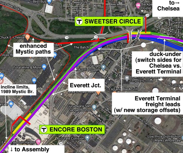
In a Phase 1 build, arguably street-running across the existing bridge for 1100 feet can be tractable, assuming it's a lower-frequency service (e.g. 6-10 min headways).

But in the long-term, and when we're talking about major expenditures, I think it's worth stepping back and first asking: Is this the best place to cross the Creek? Historically I think we've defaulted to this because it's where the original Grand Junction ROW made its crossing... but -- and I think this often gets lost -- the Grand Junction was historically a freight railroad, and its ROW through still-industrial areas reflects that.

Rail through industrial areas is often easy to build but is usually that much further away from where people live. The Grand Junction alignment has been essentially accepted as canonical because it is a shockingly well-preserved ROW that runs circumferentially and hits Airport, Sullivan, and (mostly) Kendall... but that doesn't mean it lacks downsides.

This then invites a subsequent question: Is this the best route for a rapid transit line between Sullivan and Logan Airport? Which may at first glance seem like a ridiculous question, but I think it's not: Airport Station <> Sullivan Station is 2.5 miles as the crow flies, but is double that length via the Grand Junction. I'm not denying that it still may be the best route, but I think it's important not to take it for granted.

Case in point: there is a largely extant ROW (in fact, may actually be active tracks?) that runs more than half of the distance between Airport and Sullivan, and does so with very close adherence to the as-the-crow-flies route: the freight track in Charlestown https://goo.gl/maps/v4U34WfgNs3QkbjS6. That of course still leaves you with the hard part -- getting across the harbor and crossing through Eastie to Airport. (Or even just to Maverick. See spoiler box below.) But, at least personally, I was surprised to realize how close the Charlestown corridor actually gets you.

In any case, if you are able to relieve the northeast Grand Junction of the Airport <> Sullivan load, then probably you can get away with lower frequencies, making the street-running alternative more viable.

That all being said -- yes, in all likelihood this is the best way to build Airport <> Sullivan, and yes, in all likelihood this is the best way to cross Chelsea Creek, because it will be an order of magnitude cheaper than tunneling (even with a high new bridge and detangled spaghetti). I'm just saying, it's important to step back every so often.
Maverick has historically been the anchor point for the transit network radiating to the northeast: it was the original terminus of the Blue Line, and all of the feeder bus routes to Revere and Chelsea transfer here -- not at Airport.

One of the big downsides of anchoring at Maverick, though, is losing the connectivity to Logan. But I recently saw a crayon map (somewhere, maybe MetroDreamin?) that pointed out that Maverick is not actually that far from "Logan Land" -- only 2000 feet down Maverick St to the rental car lot, and only 1500 feet up Bremen (through currently empty parking lots) to the East Boston Memorial Park area. Now, obviously both of those corridors would require non-trivial builds with neighborhood impact, so you can't take for granted that it's usable... but again, worth considering what the possibilities could be.

EDIT: If you cross here, north of the oil tanks, do you reduce the need for a drawbridge and/or the frequency of openings?
 
EDIT: If you cross here, north of the oil tanks, do you reduce the need for a drawbridge and/or the frequency of openings?

No. The Global Petroleum docks that take the big tankers are north of there another 2500 ft. north of that on the east bank of the river. You'd be closer to Revere Beach Parkway before you'd be able to do a squat fixed bridge.
 
Case in point: there is a largely extant ROW (in fact, may actually be active tracks?) that runs more than half of the distance between Airport and Sullivan, and does so with very close adherence to the as-the-crow-flies route: the freight track in Charlestown https://goo.gl/maps/v4U34WfgNs3QkbjS6. That of course still leaves you with the hard part -- getting across the harbor and crossing through Eastie to Airport.

Car! Floats! Car! Floats! Hy-dro-foil! Car floats!

(sorry)
 
My super-back-of-the-napkin math says that you'd need at least 2500ft on either side of such a bridge to get the clearance needed. On the Chelsea side that has the incline starting right after the Box District station, and on the Eastie side, that has the incline starting smack in the middle of the asphalt spaghetti around Neptune Rd, which means I have no idea where you'd actually have to start an incline, because you'd probably have to start it on the far side of the square, and that adds distance and height on top of an already sunken ROW. Worst case scenario I think you're looking at a viaduct all the way down to Airport station along whatever ROW you choose.

This is all based on the Lechmere->North Station grade of about 6.5% and a height of the bridge's current 175 ft. If you can trim that down at all, the Boston-side becomes a lot easier to fit in.
Yes, a high level LRT bridge over Chelsea Creek would require elevated rail all the way to Airport Station, passing over the East Boston Expressway. Elevating the LRT Urban Ring thru here would have the benefit of preserving the surface haul road for trucks and hauling purposes. Visually I don"t think it would be too much of an intrusion, as the elevated highway is already there.
 
Hmm, I don't have any answers here, but I wonder whether this could be a "missing the forest for the trees" kind of situation.

In a Phase 1 build, arguably street-running across the existing bridge for 1100 feet can be tractable, assuming it's a lower-frequency service (e.g. 6-10 min headways).

But in the long-term, and when we're talking about major expenditures, I think it's worth stepping back and first asking: Is this the best place to cross the Creek? Historically I think we've defaulted to this because it's where the original Grand Junction ROW made its crossing... but -- and I think this often gets lost -- the Grand Junction was historically a freight railroad, and its ROW through still-industrial areas reflects that.

Rail through industrial areas is often easy to build but is usually that much further away from where people live. The Grand Junction alignment has been essentially accepted as canonical because it is a shockingly well-preserved ROW that runs circumferentially and hits Airport, Sullivan, and (mostly) Kendall... but that doesn't mean it lacks downsides.

This then invites a subsequent question: Is this the best route for a rapid transit line between Sullivan and Logan Airport? Which may at first glance seem like a ridiculous question, but I think it's not: Airport Station <> Sullivan Station is 2.5 miles as the crow flies, but is double that length via the Grand Junction. I'm not denying that it still may be the best route, but I think it's important not to take it for granted.

Case in point: there is a largely extant ROW (in fact, may actually be active tracks?) that runs more than half of the distance between Airport and Sullivan, and does so with very close adherence to the as-the-crow-flies route: the freight track in Charlestown https://goo.gl/maps/v4U34WfgNs3QkbjS6. That of course still leaves you with the hard part -- getting across the harbor and crossing through Eastie to Airport. (Or even just to Maverick. See spoiler box below.) But, at least personally, I was surprised to realize how close the Charlestown corridor actually gets you.

In any case, if you are able to relieve the northeast Grand Junction of the Airport <> Sullivan load, then probably you can get away with lower frequencies, making the street-running alternative more viable.

That all being said -- yes, in all likelihood this is the best way to build Airport <> Sullivan, and yes, in all likelihood this is the best way to cross Chelsea Creek, because it will be an order of magnitude cheaper than tunneling (even with a high new bridge and detangled spaghetti). I'm just saying, it's important to step back every so often.
Maverick has historically been the anchor point for the transit network radiating to the northeast: it was the original terminus of the Blue Line, and all of the feeder bus routes to Revere and Chelsea transfer here -- not at Airport.

One of the big downsides of anchoring at Maverick, though, is losing the connectivity to Logan. But I recently saw a crayon map (somewhere, maybe MetroDreamin?) that pointed out that Maverick is not actually that far from "Logan Land" -- only 2000 feet down Maverick St to the rental car lot, and only 1500 feet up Bremen (through currently empty parking lots) to the East Boston Memorial Park area. Now, obviously both of those corridors would require non-trivial builds with neighborhood impact, so you can't take for granted that it's usable... but again, worth considering what the possibilities could be.

EDIT: If you cross here, north of the oil tanks, do you reduce the need for a drawbridge and/or the frequency of openings?
The Charlestown ROW for a Sullivan-Airport connection is a very creative idea, but I think the main problem with forgoing the Newburyport ROW is the loss of direct rapid transit service to Everett (Sweetser Circle)* and Chelsea, not to mention Encore.

Both Everett and Chelsea clearly deserve better transit options, but radial HRT/LRT lines are already unrealistic. With the Urban Ring routed away, at worst, they lose even circumferential service. At best - if we build parallel LRT lines along this corridor, which is politically questionable to begin with - their frequencies are halved from what they could have been, they lose one-seat rides to key destinations like Kendall, service may be worse due to grade crossings, and on top of all that, they still need to transfer to OL or BL for downtown access.

Doing all these just for time savings from Sullivan to Airport is questionable, IMO. And the ROW doesn't even seem to serve Charlestown adequately.

* Sweetser Circle is far from an ideal location to serve Everett, but it's the most realistic.
 
Thought I had to achieve some kind of pseudo through-running on the Commuter Rail:
One of the Old Colony or Greenbush Lines could run through to Back Bay and onto the Southwest Corridor for a few trips a day bypassing South Station. This would add some level of direct service to the Back Bay and Ruggles Employment centers that’s more difficult to get to from the Old Colonies potentially increasing ridership and freeing up some capacity at South Station. Any trips for people continuing to South Station/downtown are still able to transfer to the Red Line at JFK or Orange at Back Bay so those aren’t lost like Fairmount routings are. The same is largely true of return through-run trips from SWC to Old Colony. Orange Line transfers or transfers to other South Station bound trains to fulfill trips to downtown.

My experience working in Longwood for a year was that there is a hefty chunk of hospital staff coming from Southeast MA that transfer onto MASCO buses at JFK all day. It is not a fun ride during rush hour and with the CR frequencies down there missed trains and long waits are common. I would expect that a direct ride much closer to their destination would make it a much more attractive commute. Most come from Middleboro/Lakeville but with SCR coming that wouldn’t be very practical to extend. The Greenbush Line is the lowest ridership and could use the boost plus Hingham has the ferry alternative that also has the downtown connection. Kingston is the same trip length with the worst headways of the lot, yet has very solid ridership and splits the catchment difference between Greenbush and Middleboro.
 
Last edited:
Thought I had to achieve some kind of pseudo through-running on the Commuter Rail:
One of the Old Colony or Greenbush Lines could run through to Back Bay and onto the Southwest Corridor for a few trips a day bypassing South Station. This would add some level of direct service to the Back Bay and Ruggles Employment centers that’s more difficult to get to from the Old Colonies potentially increasing ridership and freeing up some capacity at South Station. Any trips for people continuing to South Station/downtown are still able to transfer to the Red Line at JFK or Orange at Back Bay so those aren’t lost like Fairmount routings are. The same is largely true of return through-run trips from SWC to Old Colony. Orange Line transfers or transfers to other South Station bound trains get fulfill trips to downtown.

My experience working in Longwood for a year was that there is a hefty chunk of hospital staff coming from Southeast MA that transfer onto MASCO buses at JFK all day. It is not a fun ride during rush hour and with the CR frequencies down there missed trains and long waits are common. I would expect that direct ride much closer to their destination would make it much more attractive of a commute. Most come from Middleboro/Lakeville but with SCR coming that would be very practical to extend. The Greenbush Line is the lowest ridership and could use the boost plus Hingham has the ferry alternative that also has the downtown connection. Kingston is the same trip length with the worst headways of the lot, yet has very solid ridership and splits the catchment difference between Greenbush and Middleboro.
This service pattern seems to have merit.

For it to work, does it have to bypass South Station, or could South Station just become a short stop -- in and back out?
 
This service pattern seems to have merit.

For it to work, does it have to bypass South Station, or could South Station just become a short stop -- in and back out?
It would probably have to be a skip. It takes a maximal number of crossover moves through the South Station throat to get from the Old Colony platforms to the NEC/Worcester main, which significantly worsens congestion at a terminal that's already very close to capacity. Remember, it's the throat movements at the interlockings and potential conflicts therein that sets the max capacity for SS...not so much the physical number of platforms. The wye, while still crossing over a large number of tracks, has significantly fewer conflicting movements at Cove interlocking on the combined NEC/Worcester lines than at Tower 1 interlocking right before the platforms. So while there's still some congestion to work across, it's nowhere near as much.

Plus to reverse on-platform you'd be down for a 10-minute layover while the engineer changed ends and did all the necessary FRA-mandated systems checks. And that's probably not going to make the schedules to BBY all that palatable.
 
Thought I had to achieve some kind of pseudo through-running on the Commuter Rail:
One of the Old Colony or Greenbush Lines could run through to Back Bay and onto the Southwest Corridor for a few trips a day bypassing South Station. This would add some level of direct service to the Back Bay and Ruggles Employment centers that’s more difficult to get to from the Old Colonies potentially increasing ridership and freeing up some capacity at South Station. Any trips for people continuing to South Station/downtown are still able to transfer to the Red Line at JFK or Orange at Back Bay so those aren’t lost like Fairmount routings are. The same is largely true of return through-run trips from SWC to Old Colony. Orange Line transfers or transfers to other South Station bound trains get fulfill trips to downtown.

My experience working in Longwood for a year was that there is a hefty chunk of hospital staff coming from Southeast MA that transfer onto MASCO buses at JFK all day. It is not a fun ride during rush hour and with the CR frequencies down there missed trains and long waits are common. I would expect that direct ride much closer to their destination would make it much more attractive of a commute. Most come from Middleboro/Lakeville but with SCR coming that would be very practical to extend. The Greenbush Line is the lowest ridership and could use the boost plus Hingham has the ferry alternative that also has the downtown connection. Kingston is the same trip length with the worst headways of the lot, yet has very solid ridership and splits the catchment difference between Greenbush and Middleboro.
Off-topic, but for Urban Ring planning, this offers another argument in favor of having the SE Urban Ring route go through South Station (or JFK/UMass for BRT) for the Regional Rail connection, instead of Broadway that's more commonly seen on some proposals.

Edit: Thinking about it again, this doesn't necessarily need to be an Urban Ring route. An LRT Back Bay-Seaport subway already provides connection from South Station to Back Bay and LMA.
 
Last edited:
The wye, while still crossing over a large number of tracks, has significantly fewer conflicting movements at Cove interlocking on the combined NEC/Worcester lines than at Tower 1 interlocking right before the platforms. So while there's still some congestion to work across, it's nowhere near as much.
The concern would be increased Fairmount frequencies or the conversion to Rapid Transit since the entire line would need to be crossed to reach the wye. Otherwise if the move is coordinated to always serve SWC Track 1 then that’s only crossing one track on that side.
The other thing would be that the train would be running flipped of all the others on one of the lines (locomotive on the north end) if that matters since it wouldn’t serve South Station.
When the Patrick Administration had its proposal for a Back Bay-BCEC dinky using the wye and Track 61, it had to slot on the Worcester platforms at Back Bay because those were the only ones low enough on congestion to fit in an on-platform turnback (ditto for any mainline turnbacks further outbound...the NEC couldn't handle it while Worcester could). So you would have to cross over the entire NEC at Cove any which way.

Locomotive direction doesn't really matter for the terminal. The T keeps an operationally consistent southbound position because the plug-in pads at all outer layovers are all on the south-facing end, but the Lake Shore Limited's inbound trip always comes into SS loco facing north so there's no exhaust restriction.
 
Edit: Thinking about it again, this doesn't necessarily need to be an Urban Ring route. An LRT Back Bay-Seaport subway already provides connection from South Station to Back Bay and LMA.
We've discussed this extensively in the Green Line Reconfig thread. A multi-directional junction at Bay Village that feeds a relocated E Line (via Back Bay) and a SS/Transitway connection can be set up to thru-route various E's to the Seaport, providing exactly that SS/BBY/LMA one-seat amongst its varied service patterns. Complete with member-created diagrams of how that junction would work to filet its service patterns.
 
When the Patrick Administration had its proposal for a Back Bay-BCEC dinky using the wye and Track 61, it had to slot on the Worcester platforms at Back Bay because those were the only ones low enough on congestion to fit in an on-platform turnback (ditto for any mainline turnbacks further outbound...the NEC couldn't handle it while Worcester could). So you would have to cross over the entire NEC at Cove any which way.
I’m a bit confused about this because I’m not suggesting a short turn in the SW corridor I’m pitching an Old Colony through-running onto an entire different line. Kingston-Stoughton was one that came to mind.
 
I’m a bit confused about this because I’m not suggesting a short turn in the SW corridor I’m pitching an Old Colony through-running onto an entire different line. Kingston-Stoughton was one that came to mind.
You're targeting the Old Colony specifically for a Back Bay seat, but you're depriving a line that already has Back Bay of a South Station seat. Isn't that trading one problem for another to zero gain?
 
It's not 0 gain, though. It's a tradeoff that provides a new service pattern. Now people from 128 and Quincy can both get one-seat rides to the opposite termini. Now, obviously, there's more to the cost/benefit than just a new service pattern, but it's not zero gain.
 
You're targeting the Old Colony specifically for a Back Bay seat, but you're depriving a line that already has Back Bay of a South Station seat. Isn't that trading one problem for another to zero gain?
No, as @ulrichomega says it’s just a new service pattern that would be only for some trips. Exactly which two lines to pair I was only spitballing as there are multiple different combinations with pros and cons to weigh. I chose Stoughton because it’s fairly short and the SW corridor has 4 other services that serve Ruggles-South Station making a transfer less painful for those trips that don’t serve the terminus. Needham could be another option extending Old Colony service to Forest Hills.
Instead of Kingston, maybe a Middleboro short-turn could be the one that extends. Brockton/Bridgewater gets a 1seat to Ruggles and there’s more reason to connect a SW corridor line to BSU than anything on the Kingston. BAT service to Stoughton/Canton also means people can take either line home or in this case, either direction, now creating more departures and increasing service to an area without additional trains.
 
F-Line to Dudley said:
You're targeting the Old Colony specifically for a Back Bay seat, but you're depriving a line that already has Back Bay of a South Station seat. Isn't that trading one problem for another to zero gain?
No, as @ulrichomega says it’s just a new service pattern that would be only for some trips. Exactly which two lines to pair I was only spitballing as there are multiple different combinations with pros and cons to weigh. I chose Stoughton because it’s fairly short and the SW corridor has 4 other services that serve Ruggles-South Station making a transfer less painful for those trips that don’t serve the terminus. Needham could be another option extending Old Colony service to Forest Hills.
Instead of Kingston, maybe a Middleboro short-turn could be the one that extends. Brockton/Bridgewater gets a 1seat to Ruggles and there’s more reason to connect a SW corridor line to BSU than anything on the Kingston. BAT service to Stoughton/Canton also means people can take either line home or in this case, either direction, now creating more departures and increasing service to an area without additional trains.
I think @F-Line's point is that there aren't a lot of free slots on the NEC right now, so the new Old Colony <> Back Bay service would potentially need to steal an existing NEC train's slot, effectively diverting that NEC train away from South Station.

In practice, I'm not entirely sure it's so simple, since the OC train would be stealing a reverse peak NEC train's slot, and I'm not sure the NEC is maximally congested in the reverse peak direction. (Although, at the same time, NEC reverse peak capacity is definitely lower than its peak capacity, so, you win some you lose some.)

Two other problems with OC <> NEC via Back Bay (neither of them fatal, but neither of them trivial):

First, the OC train would need to make multiple crossings to reach a suitable track, including all of the tracks from Southampton Yard (disrupting movements in and out of service) as well as (likely) multiple tracks on the NEC. The closest track on the NEC is (I believe ) Track 2, which is the easternmost track, but that would conflict with any AM peak traffic using it as an inbound track. Running OC service to Needham has some benefits, but requires crossing over all the NEC tracks. It's a solvable problem, to be clear, but it makes things more complicated.

The second problem is that by interlining service, you are now further interlining the rolling stock fleets of the different lines. Now, it's not like the T has some sort of transit-platonic ideal of dedicated rolling stock per line -- from my time piecing together turntables, there's a lot of crossover -- but they do have some general divisions in assignments. Sending some fraction of peak Middleboro trains back out to Stoughton now means that the Middleboro fleet is intertwined with the Stoughton fleet, which really means that the OC fleet is intertwined with the NEC fleet. Again, solvable, but more complicated.

A more reasonable solution all around would be to run a shuttle train back and forth between South Station and Back Bay on the Worcester tracks, scheduled interspersed between other departures so that there is never more than (say) a 10-min gap during peak. (Maybe run it all the way to Lansdowne to provide better access to Longwood.)
Yeah I see all your points. There’s a reason I put this in crazy transit pitches. My thought was not any additional service but taking existing trips that roughly line up so that there’s no change in number of trains on OC or SWC only minor schedule and track adjustments. The main goal of the thought experiment was to find any kind of somewhat sensible interlining that would not require NSRL as that’d take a decade from the start of construction to be in service.
 
This reply has been languishing as a draft for days. Hopefully I can actually knock it out now...
The Charlestown ROW for a Sullivan-Airport connection is a very creative idea, but I think the main problem with forgoing the Newburyport ROW is the loss of direct rapid transit service to Everett (Sweetser Circle)* and Chelsea, not to mention Encore.

Both Everett and Chelsea clearly deserve better transit options, but radial HRT/LRT lines are already unrealistic. With the Urban Ring routed away, at worst, they lose even circumferential service. At best - if we build parallel LRT lines along this corridor, which is politically questionable to begin with - their frequencies are halved from what they could have been, they lose one-seat rides to key destinations like Kendall, service may be worse due to grade crossings, and on top of all that, they still need to transfer to OL or BL for downtown access.

Doing all these just for time savings from Sullivan to Airport is questionable, IMO. And the ROW doesn't even seem to serve Charlestown adequately.

* Sweetser Circle is far from an ideal location to serve Everett, but it's the most realistic.
Oh sorry, to be clear: this is all in addition to a Chelsea <> Sullivan service, one which maybe even extends to Airport (maybe with some short turns in Chelsea).

Your point about loss of freqs to Kendall is well-taken, but this Airport/Charlestown route doesn’t necessarily have to go to Kendall (leaving Kendall available for full freqs from Chelsea); Kendall is just about a third of the way around the Airport-Sullivan-Kendall-Longwood-Nubian-Airport circle, which is as far as you can go on a circumferential route before it becomes a shorter distance to take radial routes in and out of the core:
  • Airport-Charles/MGH-Kendall: 3.3 miles
  • Airport-Charlestown-Sullivan-Kendall: 4.3 miles
  • Airport-Chelsea-Sullivan-Kendall: 6.7 miles
This means that, regardless of alignment, no one is going to take the Urban Ring from Airport to Kendall. That means that there are two objectives for an Eastie-originating circumferential service:
  • Eastie <> Chelsea/Everett
  • Eastie <> Sullivan
And of those, I would suggest that the Sullivan objective takes priority in terms of capital expenditures. My point being, we shouldn't ask, "What's the best way to cross Chelsea Creek?", we should ask, "What's the best way to get from East Boston to Sullivan?" And I agree that the answer to that second question usually is gonna be, "Chelsea Creek", which of course returns us to the first question. My point is just that we shouldn't lose sight of the first question really being in service of the second question.

On the question of time savings: at 15 mph, the Eastie <> Chelsea <> Sullivan journey is just under 5 miles and just under 20 minutes. That's really not much better than today's scheduled time via Orange + Blue. So, that leads us to ask: what would the difference in ridership be between a Sullivan <> Chelsea LRT service vs a Sullivan <> Chelsea <> Airport LRT service? I'd argue that it looks possible that the difference would solely come from Eastie <> Chelsea journeys, which, while non-trivial, probably do not need a full grade-separated LRT line.

Just for the sake of example, consider a design like this, which splits up Sullivan <> Chelsea and Chelsea <> Airport into two separate services:

1691242947049.png

  • Gold: crosstown service Kendall <> Everett and Kendall <> Chelsea (grade separated LRT)
  • Dark Teal: crosstown service Watertown <> Sullivan <> northeast (grade separated LRT)
    • Optionally, Dark Teal could eat or interline with the Chelsea branch of the Gold
  • Magenta: circumferential service Chelsea <> Airport terminals (separated BRT in Chelsea, mixed over the bridge, surface BRT to terminals)
  • Silver: radial service Downtown <> Chelsea (T111) (surface BRT)
Creating a grade-separated crossing over Chelsea Creek would add significant expense to an Urban Ring build. The rest of the Kendall <> Chelsea corridor can be built without street-running at much more modest costs. Splitting off the Chelsea <> Airport segment into its own service would increase reliability on both segments, and relieve the pressure for a grade-separated crossing in the first place.
 

Back
Top