Thanks for all the feedback! My girlfriend thinks I'm crazy and all I get from her is "that's nice".
The land mass/waterway blur is jarring. I like the way you were originally representing land/water with the lighter blue and crisp edges.
Believe it or not, the first version was blurred too. But 1 pixel vs two. I agree its jarring, and will fix it on the next iteration. I think I'm going to stick with the darker color though, I want the background, CR and Ferrys to be washed out so they don't compete with the RT lines.
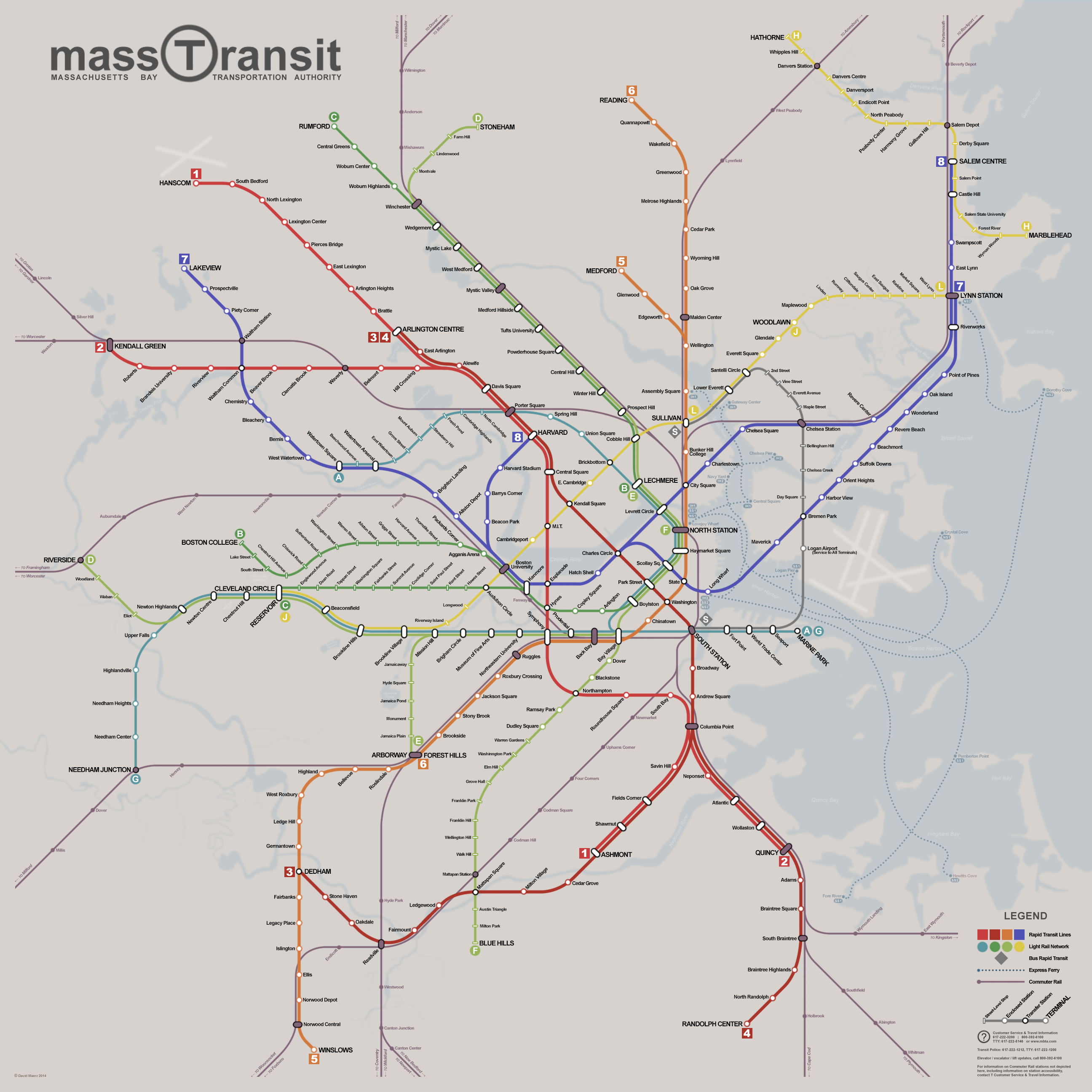
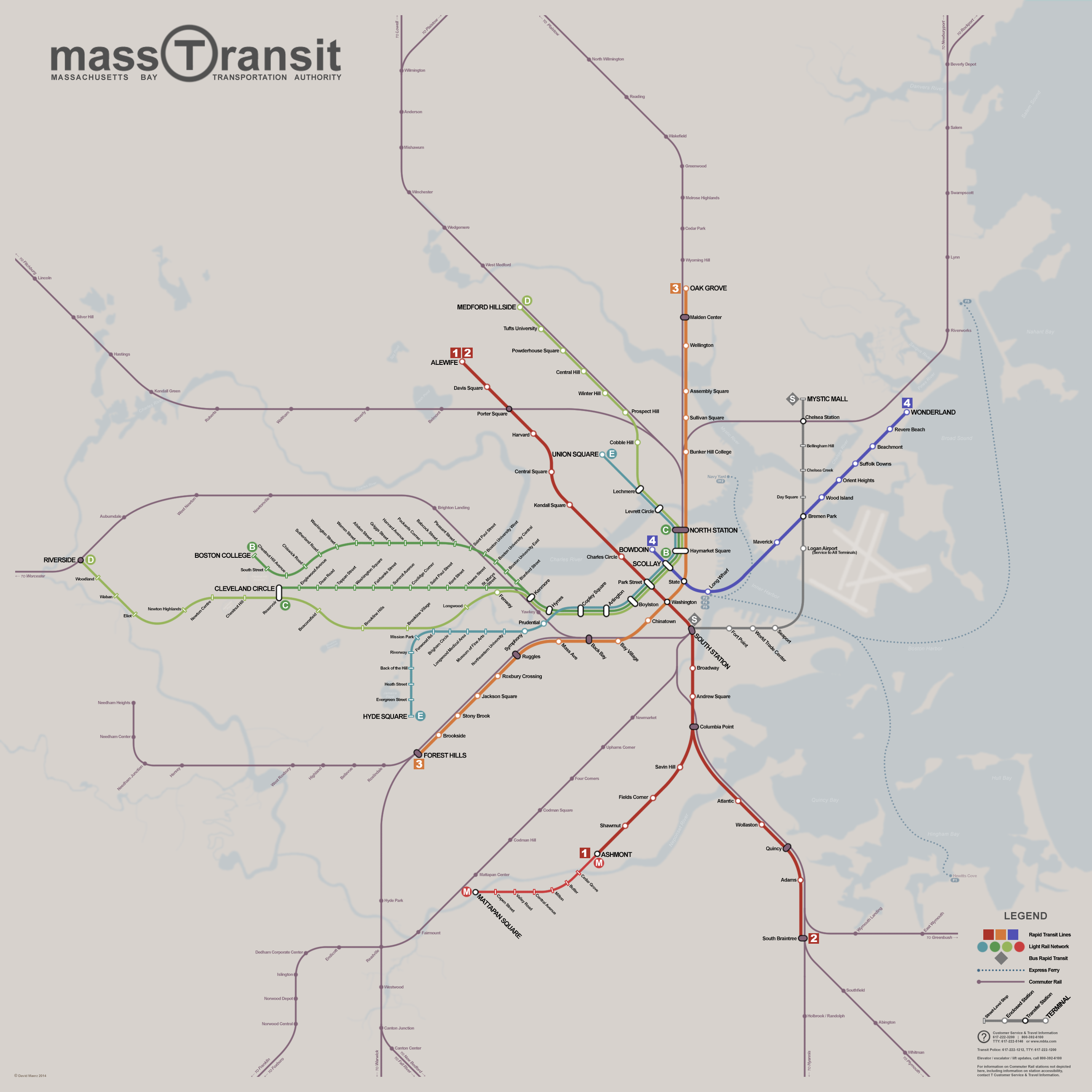
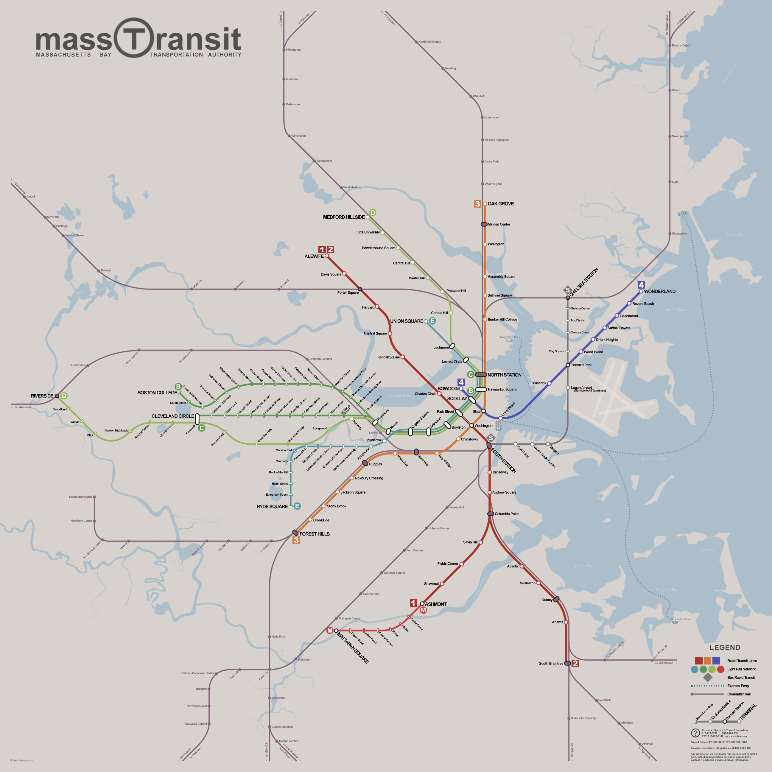
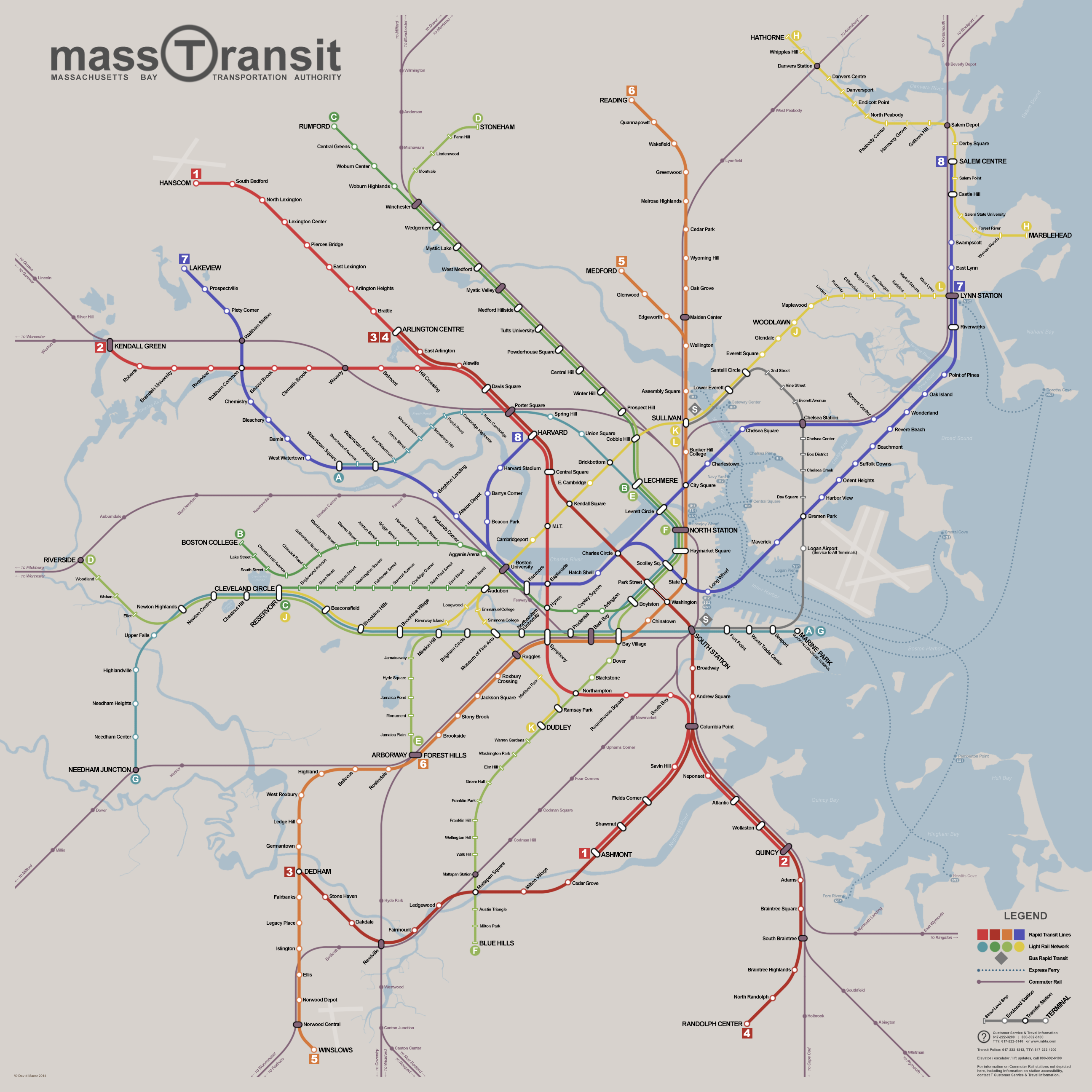
One thing on the current map. Chelsea station on the commuter rail will be moved to Mystic Mall and integrated with the SL terminus. The existing station site will become SL only.
I haven't been following the Silver Line extension that closely, I'll have to update it with the real stops.
neither you nor C_Combat have included Indigo, though you did imply its existence with a CR stop at Riverside. Also, the E line only goes to Hyde Square in your dreams. ")
Yeah, I plan to do a CR map that illustrates all the DMU lines, and would imagine it placed in all the stations next to the transit map. (Ideally there would also be a SEPARATE key routes bus map as well).
As for Hyde Square, I thought they were studying reopening it to there? It seemed feasible so I threw it in. Then again so is the red/blue and I didn't deem that possible...
I notice that you did 3 unique LRT colors (B/C, D, and E), which is an interesting solution to the problem of different shades of green being tough to discern from the gray. I still think the D color has that issue, though. Really (and this is more my own thinking than a comment on your map) the D should carry the green color, while the streetcars get Teal and Brown, since primary colors should go to grade-separated routes. Alternately, you could argue that B/C is the "true" Green Line since it's what people most think of, and in that case D gets the brown color.
You hit the nail on the head: It's the "classic" green line. The D was originally a much brighter lime, but it irradiated itself right off the page. I had the same issue with the gold line
(get it, silver and gold lines!). I'm looking at it in greyscale now, and believe it or not the teal and green are actually harder to discern than the lime, which reads pretty well. The two that are hardest to dicern without color is blue and crimson, which are nearly identical in shade. But since they are never parallel I don't think it much matters. I'll admit thinking about color blindness was a thought, but it was the least of them. Although looking at it right now its not that bad at all. Having LRT, HRT and CR be different size lines helps a lot.
My thought process was to base the color system off of what trunk they use. B/C through the Boylston subway, D/E/F through the Huntington subway, A/G through the transitway, 1/2 through Mass Ave and 3/4 through downtown.
-B/C get the classic emerald green, as they continue to go through the Boylston Subway (classic green line), which also follows the Comm Ave mall. Since the reason green was chosen by Cambridge 7 was because it followed the Emerald Necklace, it made sense to stick with that. (I know the E does too, its not perfect!)
-D/E get lime, because lime is closer to emerald, and since D&E are part of the current green line it makes sense for their color to be closer. Lime is also what you get if you mix green and yellow, and since the gold line picks up a bit of the former D from Brookline Village to Fenway, it made my color theory self happy. The F got it because it follows the D&E trunk.
-The A/G got teal because teal is halfway between blue and green, and also blends nicely with silver. Teal is also close to blue, the color of water, and since both lines end at the seaport, and the A runs to WATERtown, this worked nicely as well. Since the A&G are both brand new service, they share very little in common with the existing green line except sharing the Trunk through Tremont and Huntington, so their color was the furthest removed of the three.
-The 3/4 got crimson because that is Harvards color, and the red line was chosen to be red for that very reason. the 3,4 is also closest to today's service pattern (classic red line).
-The 1/2 got scarlet because, well, its still red but different.
-The gold lines are gold, because while it shares yellow with the buses, the H/J/L all run on the surface with the exception of a subway under Broadway from Everett Square to Maplewood. I actually tried using brown, but it looked, well, like poop.
Of course, then you'd need to paint the LRT trains in a common livery, but I think the T just can't avoid differentiating the light rail branches once Medford opens. This is the largest LRT system in the country by ridership. It would be a mature transit system on its own in every other US city save NY, Chicago and DC (in SF this IS basically their transit system).
It's beyond silly that the MBTA continues to insist on their signage that such a network is one line. It's time for them to stop changing the termini every 5 minutes and commit to routings (which they're doing anyway for GLX) and use a map which actually tells you where the damn train is going.
Agree x1000. As for the livery scheme, if the map were to use different colors for LRT, I would like to see the classic "creamsicle" scheme the Mattapan PCCs use revived for the entire fleet. The
one Boeing LRV painted that way looks INCREDIBLE, and I'm sure the Type 7s would look amazing in it as well. The emerald green paintjob isn't bad, but the traction orange and creme is drop dead gorgeous. (In a similar vein, the commuter rail should go with the maroon
1107 and
1104 were accidentally painted in instead of the godawful fuchsia they use now.
Yeah, Dave's is really harkening back to days of truly insane transit maps =)
I might do a "slightly less crazy" version, or a few maps showing phased extensions. But for this one, I decided since I was doing so much work I would take it as far as the system could handle, although I did limit myself to existing ROWs for the most part. The only things I deemed completely insane were a Harvard Ave subway (less important with all the E-W service) and extending the 8 past Harvard to Union Square through Inman Square. As for what I deemed crazy but not insane:
-Bringing the 7 north past Waltham to 128 is an old idea of Vans I read years ago on his site and made a ton of sense, as there is a boatload of land right there that could be redeveloped.
-An Everett Subway under Broadway is a major undertaking, but opens up an entire quadrant of the area previously inaccessible by transit and would be a boon for the region. It doesn't hurt it smacks into the Saugus branch where it becomes useful and they are building a bunch of new development either.
-The 5 going from West Roxbury to Norwood would not use the old railroad ROW, as it has been almost entirely obliterated. Instead, it would run in a short subway beneeth Belle Ave, before portaling and running as an el or open cut along the east side of the VFW parkway. There is a wide buffer between the highway and the parking lots there, so this wouldn't be an issue at all. Through Dedham Center it would run underground as a subway, before emerging again to run as an el/open cut alongside route 1 to 95, where it would pick up the railroad ROW again.
-The F past Mattapan to the end of the Blue Hills Parkway is a concession for removing all but one Milton stop on the old high speed line. There is a wide median there. Running the F continously from North Station to Milton means burying the line as a subway all the way to Dudley. I think this should be done anyway. If not made a subway, then the line would have to be split, requiring a transfer at Dudley to continue into town. That median down Blue Hill Ave is just two damned tempting as a light rail line to not use it.
-The C to Rumford (north Woburn) may be a bit crazy, but if you are extending the green line all the way out there, it makes a lot more sense to run via the old Woburn Branch instead of the current route of the CR, which goes between population centers instead of through them. It's mostly intact to Woburn Center, the two stops beyond that are far more dicey since that half was abandoned much earlier. It would be more realistic to end it in Woburn Center, but again, this is the furthest I think the system could go.
-D to Stoneham for the same reasons as above, and that ROW is largely intact. I also like ending my branches at individual terminals instead of just a station along the line. Stoneham, like Woburn, has a lot of parking lots that could be developed, and the line nicely hits almost every one of them.
-the 5 to Medford is hard, but not impossible. The ROW is "intact" as far as 93 for cut and cover. Intact meaning only one house, but everyones backyards and garages would have to be demolished and rebuilt. Then you just have to tunnel under 93 and build a terminal under Riverside Ave. Medford will get transit access at Medford Hillside, but it requires walking almost a half mile and across RT16. While this would be expensive, it would open up Medford Center for more development, and the area of industrial properties around RT28. Even if going all the way to Medford is infeasable, Wellington is a godawful station in a terrible place. Just building a one station spur to Edgeworth at RT28 (where there are still tracks on the ROW) would be a large improvement for neighborhood access and TOD development.
-The H to Marblehead is a stretch, more because its Marblehead than anything else. Salem State is a far more likely terminal. I do think running a trolley out to Danvers State (Hathorne) would be good, as there is a MASSIVE amount of underused land along the route, and it also gets transit access to Danvers and Peabody, which are difficult to serve on their own but could really use it. For maintenance, the H trolleys could run down the Blue Line to Lynn, since the blue line thankfully uses the same overhead catenary. A small yard could be built in Peabody on one of the other two ROWs I didn't use for storage.
-8 via Tobin Bridge is also a stretch, but not impossible. It looks like some reworking of the structural supports of the tobin would allow rail to be built within the current structure as long as the loads work out. Otherwise it could be built after the Tobins useful life is up, and route 1 gets rerouted via the eastern route through Everett and connects south of Assembly. Before that it could connect using the abandoned east boston branch from Airport to Revere Center.
-1 to Hanscom instead of Bedford is pretty easy, there is a manure farm or something (landscaping company?) that would make a perfect park and ride, and the rest of the way to the airport would be an el runing along the side of Hartwell Ave/Barksdale St, which runs directly to the front of the civillian terminal. This would give the Boston region TWO airports directly on the transit lines. I know people in Bedford don't like the idea of Hanscom being used as a real airport, but it's either that or Norwood as a Logan alternate, and Hanscom has more expansion room.
-I did NOT reactivate the original A through Brighton, instead supplementing it with the blue line, reopening the Faneuil and Newton Corner CR stations, and having the teal line ending in Watertown. This was more a pretty lines decision than anything else, I might play with restoring it from Oak Square to Kenmore.
The most important thing I tried to do with my extensions and routings was not just get people into and around Boston, but also into and around the satellite cities. This is why Waltham, Lynn, Watertown, Dedham, and to a lesser extent Quincy all have redundant service. (Quincy is developed pretty lineally along the red line, and also has very few other options for more transit lines). The only other ROW through there I'm aware of was taken over by 93, and there's little TOD potential along it anyway.)
Lynn has the 7, which is local service not useful for getting to Boston, but very useful for getting around Revere. the 8 is express service to get into Boston, and also connects Lynn to Salem. The gold line would be torture to ride all the way into Boston, but is very good for getting around, and opens up some vacant areas to development. Same thing with Waltham, it gets redundant service with both blue and red running through it, not just to it. The A to watertown is useless for getting downtown, but very good for getting to Cambridge and around Watertown itself. This is also why I extended service to Randolph and Norwood. I think these satellites are going to be very important places to house people and business if the metro area continues to expand, and getting them service should be of utmost importance.
That was a lot of text for such a small comment!
Among an abundance of other things, I like especially the inner harbor ferry service. Direct downtown access from Central Square (Eastie) and Chelsea waterfront would be completely transformative, and very easy to implement (at least compared with the rest of this amazing moonshot).
Thanks! I tried to suppliment otherwise complicated connections with the inner harbor ferrys. So with the IH1, while Central Square has decent accessibility to the south side of Boston via the 7, the ferry gives direct access to the north side. Same with the IH2, chelsea and charlestown can get to the north side no proplem with the 8, but notsomuch the south. "Gateway Center" is of course a placeholder for "Casino".
You've also hinted at some interesting choices about rail service in the Merrimack valley and southern NH - there's a notional zoomed out version of this with an equally crazy regional rail story going on.
Kudos on embedding a more-traditional station naming scheme - aquarium, courthouse, and government center are named after institutions, but Scollay Square, Fort Point, and Long Wharf are districts, and so are infinitely better as station names.
SO GLAD someone caught onto these two subtitle things. You are correct, there is a much beefier CR system I have planned out. Check out the
google maps version of this. it's still a work in progress but you can see where I'm going. My purple spider has spawned a baby in providence, and I'm working on NH service now (their network is in terrible condition, its hard to find a ROW thats not just gone)
As for the names, I can't stand the modern renamings, they are all sterile and devoid of sense of place and community ties. Downtown Crossing, Silver Line Way, Science Park? Ugh. With all my station names, I used old maps. So if there was a historic rail station, it got that name. Otherwise it is named after the neighborhood or a nearby feature (hence so many hills, parks, and cemetery station names). I wanted to rename "Hynes" back to "Massachusetts" as well (since the Symphony name would be extended to the Mass Ave OL station once connected), but it didn't fit. Likewise, I can't decide on either "Hatch Shell" or "Beacon Hill". I also prefer "Black Falcon Terminal" as the A/G terminal, but it looks too long on the map. I'm not sold on "Marine Park", but I hate Design Center, and want it to hint that the Cruise Ship terminal is there.
And if your "8" blue line is going through the city square tunnel and over the lower deck of a remodeled Tobin, with glass-walled "son of Charles / MGH" stations on either end, high above the Mystic....well that would be awesome.
As I mentioned above, it would use the routing of the Tobin. Whether concurrently or after it's demolition depends on if it could be grafted onto or not. The thought of the BL roaring across a lower deck of the Tobin is magnificent though.
I'd save the GJ for the Urban Ring myself. Keep the Riverside line on the current via Kenmore routing, and send the Needham trains up Huntington (which would be buried and connected to Brookline Village).
I've never been a fan of the ring myself, as ring routes are not really useful to ride their full length. Plus the ring depends on somehow getting through Brookline towards Dudley, and also across the Harbor. So either its going to cost a bazillion dollars, or its going to be mixed mode requiring transfers anyway. Therefore I decided to construct the most logical aspects of the ring, with each leg using the mode most convenient and suited to it (BRT, LRT or HRT) and then extend to useful places beyond there. The gold line running to Reservoir from BU is mostly because its the easiest way to connect Cambridge to Brookline, and I think abandoning that short stretch would be a bad move. I want the D to go via Huntington so it can hit Back Bay station and the Orange Line transfers. The GJ is also easiest to convert to LR (grade crossings are a non-issue), and Reservoir is the natural terminal since its already set up that way. The 1/2 down Mass Ave is another aspect of the ring, and makes sense to run with full subway cars. The silver line from SS to Chelsea allows BRT to still be used through the Ted to Logan, and also allows it to run down RT16 through Everett, hitting closer to peoples homes and business than it would running via the railroad.
As a side note, the existing connections that are not used in the mapped routings would still be retained for special service. So a train could for instance run Park > Copley > Back Bay > Seaport using the old copley junction, or Reservoir > Kenmore > Park. The latter routing would be useful for game days at Fenway, while the former would be good for large conventions. Bay Village would also be configured as a loop, allowing all trains coming from the North able to be short turned.
I think it's a very clever solution to send the (current) D line down the (current) E track, and branch another service via existing Longwood track up Park Drive and across to the Grand Junction in Cambridge. Although, looking at your googlemap, I'm not sure why you're relying on a new bridge or tunnel to get the LRVs across.
It also allows the D to express through Beaconsfield, and possibly Brookline Hills (I keep going back and forth on this one). I might have the G express through them as well.
Cambridge > BU would be a tunnel, and mostly it's because I think it would be easier to build a new tunnel under the charles than to try to get down below the B&A, Blue Line, Green line and pike in the small amount of space between the end of the bridge and Mountfort St. It would also allow for the demolition of the existing bridge, which would pretty up the area, and allow the bike path to not have to use that damned wooden bridge thats turns are so sharp people almost always hit me.
Also: I really wish I had Adobe Illustrator right now... my MapsEngine map seems passé now haha.
Got photoshop? That's what I've been using. Otherwise inkscape does work, and I think the gimp also has a paths tool, although I haven't used it in years. Google mapmaker is great to figure out the exact routings and also how the lines interact with each other. Without it I never would have had a shot at making this map.
I have to admit I've never heard of Winslows or Rumford! What's the great big "fantasy" of bringing transit to those places? This map looks to me like a hybrid commuter rail system, sort of like in the DC suburbs, or the far-flung reaches of some of London's Tube lines out beyond the M25. I'd think that the priority would be investing in transit network density through the more densely populated areas, which would sometimes mean extensions - Roxbury, Watertown, Lynn, Roslindale and even possibly Waltham come immediately to mind - but I've never driven past Legacy Place and thought "wouldn't it be great if the Red Line came here..."
I can't remember where I found the Rumford name, but it does have some historic precedence.
For the most part, I extended all the transit lines out to 128, Rumford is the place nearest Woburn with access to a ramp and some land for a parking lot. There's a mini village there as well, and most importantly, prime TOD land.
Winslows is (I believe) the name of a former railroad station at the junction south of Norwood Central. I dug up a bunch of old names for my stations, but it was years ago so I don't remember the source for all of them. Basically, I wanted to get to Norwood because it has a ton of developable land in its core. There's no room for a terminal at Norwood Central through (especially since there would also be a CR stop), so I went south to the abandoned Wapole Branch to get room for tail tracks. Theres a bunch of prime TOD land and a few redevelopable old mills there too, and it's got great access to RT 1. Basically its Alewife for the Orange Line.
Anywhere a line is running through what is currently nothing, its either to get to a park and ride terminal, or because I believe it has a lot of potential for TOD. Lakeview on the blue line is a prime example, its currently office parks and parking lots, but I could see towers popping up along 128. Reading and the Orange Line through Dedham are two other places that could support a lot more development.
I'm also trying to take some of the load off of the CR so it's role can be consolidated to only outside 128 with the exception of the fairmont and B&A. Mostly this is so the system can be extended to 495 and beyond, increasing the reach of the metropolitan region but not crippling trip times. Inside 128, the role of the CR would be as an express downtown, except for the aforementioned lines, which would continue to need DMUs.