You are using an out of date browser. It may not display this or other websites correctly.
You should upgrade or use an alternative browser.
You should upgrade or use an alternative browser.
Boston in the 1960's
- Thread starter JohnAKeith
- Start date
kz1000ps
Senior Member
- Joined
- May 28, 2006
- Messages
- 9,186
- Reaction score
- 13,716
Case in point, here's what was going on in Mission Hill/Huntington Ave circa 1964:

What had been there...

These were taken from the City Archives' set on this project over at Flickr.
What had been there...
These were taken from the City Archives' set on this project over at Flickr.
- Joined
- Sep 15, 2010
- Messages
- 8,894
- Reaction score
- 274
^ Fantastic pix. This was the Whittier St Redevelopment Project that saw the destruction of Whittier St (the stub on the other side of Tremont still exists) and saw the rise of 3 towers - The Charlesbank Co-Op (you can actually see the pit for it in the first photo), Back Bay Manor/CityView at Longwood, and The Longwood.
Last edited:
kz1000ps
Senior Member
- Joined
- May 28, 2006
- Messages
- 9,186
- Reaction score
- 13,716

Ron Newman
Senior Member
- Joined
- May 30, 2006
- Messages
- 8,395
- Reaction score
- 14
Was the purpose of these (Whittier Street) towers to house medical students, doctors, or other employees of the nearby hospitals?
Id never noticed this thread... some of these are great - I have lots of good West End/Govt Ctr clearance pics, but that aerial takes the cake. Wow. Also, as much as Ive laboriously gone through the city archive photos, I still havent found much of Lower Roxbury/Mission Hill. Have specifically always wanted to see the little Mission Hill Triangle neighborhood pre-destruction. I didn't know about Whittier Street, but Smith (named after the founder of MassArt) also got split in half by those horrible towers. It's annoying, too, since those towers make it impossible to get from Huntington to St Alphonsus and the streets behind it on foot without walking way around.
KZ or anyone: in the clearance pic above, what's the giant pit up next to Brigham Circle? It's where Stop & Shop etc is now and I cant remember what was there before, I just have a sense of it being a fairly vacant area. I think I recall that Harvard had planned to build something big there before Roxbury Tenants of Hvd fought them off, but whatever is going on in the pic there looks like a pretty big excavation and I dont remember anything being there pre-S&S quite so large.... So what is/was it for?
KZ or anyone: in the clearance pic above, what's the giant pit up next to Brigham Circle? It's where Stop & Shop etc is now and I cant remember what was there before, I just have a sense of it being a fairly vacant area. I think I recall that Harvard had planned to build something big there before Roxbury Tenants of Hvd fought them off, but whatever is going on in the pic there looks like a pretty big excavation and I dont remember anything being there pre-S&S quite so large.... So what is/was it for?
kz1000ps
Senior Member
- Joined
- May 28, 2006
- Messages
- 9,186
- Reaction score
- 13,716
That pit was an old quarry that yielded the famous Roxbury Puddingstone used all over the place in the 1800s. As best as I can tell it sat abandoned from around the '50s-ish on up until redevelopment with One Brigham Circle back in 2002. I have no idea about any previous proposals for the site though I am now curious.
timsox6
Active Member
- Joined
- Feb 16, 2013
- Messages
- 683
- Reaction score
- 0
Got a question for people here, though it may be more appropriate in a different thread: how do you feel about the urban renewal destruction of past decades in Boston? Obviously it wasn't good that the city destroyed neighborhoods and ways of life and history. But at the same time, without those urban renewal mistakes, we might not today be experiencing the same type of growth around the whole city, much of which is building up either vacant lots or ugly urban renewal-era buildings created at that time. Thoughts?
fattony
Senior Member
- Joined
- Jan 28, 2013
- Messages
- 2,099
- Reaction score
- 482
Got a question for people here, though it may be more appropriate in a different thread: how do you feel about the urban renewal destruction of past decades in Boston? Obviously it wasn't good that the city destroyed neighborhoods and ways of life and history. But at the same time, without those urban renewal mistakes, we might not today be experiencing the same type of growth around the whole city, much of which is building up either vacant lots or ugly urban renewal-era buildings created at that time. Thoughts?
The wrecking balls indiscriminately took crap and excellent buildings alike. I would have much preferred to see targeted demo and re-infill (maybe adding a few stories here and there over the decades to account for growth) than clearing whole blocks to ultimately be replaced by the likes of The Victor.
We wouldn't need as many larger/taller developments as we need today today if we preserved a fine-grained web of narrow streets lined end-to-end in 3-5 story buildings. The thing that many in the anti-development, anti-height crowd don't understand is that no one is bringing back the narrow streets that allow for low-rise buildings to reach the critical mass of density to feel truly urban. A few tall buildings separated by wide boulevards, ramps, and parking lots end up with the same or lower density of people than those old neighborhoods had. Now that we are stuck with more auto infrastructure, the only way to reach the old density is by building much higher than in the old days.
Look at infill developments throughout South Boston, Cambridge, and Somerville or any place that avoided the wrecking ball. They knock down or redevelop dilapidated structures and replace them with something a little bigger. That should have been the norm in every corner of the city forever.
That pit was an old quarry that yielded the famous Roxbury Puddingstone used all over the place in the 1800s. As best as I can tell it sat abandoned from around the '50s-ish on up until redevelopment with One Brigham Circle back in 2002. I have no idea about any previous proposals for the site though I am now curious.
Huh. Very cool. There's a fair amount of stuff about the roxbury tenants of harvard and the redevelopment of that area by the hospitals and med school … I think most of what I read I found on archive.org, and some old online harvard crimson articles which come up by searching the right keywords... and I seem to remember a possible proposal to build the school of public health there, maybe. What i definitely recall reading is that harvard bought up all of the fenwood area, then deliberately didn't maintain it to make it look more blighted.
I still would love to see more photos of the mission housing project area predemo, and also the whole ruggles area, too... Must've been a lot of factory buildings, I imagine.
Got a question for people here, though it may be more appropriate in a different thread: how do you feel about the urban renewal destruction of past decades in Boston? Obviously it wasn't good that the city destroyed neighborhoods and ways of life and history. But at the same time, without those urban renewal mistakes, we might not today be experiencing the same type of growth around the whole city, much of which is building up either vacant lots or ugly urban renewal-era buildings created at that time. Thoughts?
It was terrible. An irreplaceable loss. I wasn't around for most of it, obviously, but whenever I walk through the neighborhoods that survived I am reminded of just how much more there used to be, and how much was lost.
We are still dealing with the scars of those 1960s decisions every day. In Roxbury, they are open and festering -- it seems like the city is only beginning to come to terms with what happened decades ago. Where I live, in Allston, the continuing woes and decay of the Mass Pike extension are a constant reminder of the hubris of the urban renewal era.
The even sadder part is that it doesn't have to be this way. It's just that we don't seem to be able to duplicate the kind of city building featured prior to the 20th century. It's a lost art. So whatever was demolished is gone for good, and the replacement is almost always compromised in some way. Usually for parking, or auto LOS, or something like that.
- Joined
- Sep 15, 2010
- Messages
- 8,894
- Reaction score
- 274
Huh. Very cool. There's a fair amount of stuff about the roxbury tenants of harvard and the redevelopment of that area by the hospitals and med school … I think most of what I read I found on archive.org, and some old online harvard crimson articles which come up by searching the right keywords... and I seem to remember a possible proposal to build the school of public health there, maybe. What i definitely recall reading is that harvard bought up all of the fenwood area, then deliberately didn't maintain it to make it look more blighted.
I still would love to see more photos of the mission housing project area predemo, and also the whole ruggles area, too... Must've been a lot of factory buildings, I imagine.
https://www.flickr.com/photos/cityofbostonarchives/sets/72157631800085692/
Last picture: Look at the smiles on their faces after destroying half of an entire neighborhood.
Also, someone else had posted this 1884 image in the Brigham Circle thread:
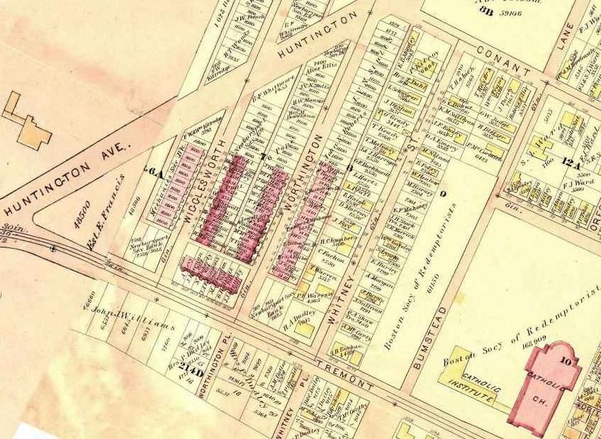
I have a lot more pix of the ward maps for Roxbury & Brigham Circle somewhere on my computer (from when I went to the BPL and did a lot of research for my final studio project), but I can't seem to find them right now for some reason.
Awesome. The pic that says it's the northwesterly corner of Whittier and Tremont is hard to believe, both streets look so narrow. Crazy. But yeah, I guess worthington and wigglesworth were the only streets with those nice row houses the rest of the streets being more regular old boston housing stock.
bobthebuilder
Active Member
- Joined
- Oct 17, 2013
- Messages
- 434
- Reaction score
- 159
Got a question for people here, though it may be more appropriate in a different thread: how do you feel about the urban renewal destruction of past decades in Boston? Obviously it wasn't good that the city destroyed neighborhoods and ways of life and history. But at the same time, without those urban renewal mistakes, we might not today be experiencing the same type of growth around the whole city, much of which is building up either vacant lots or ugly urban renewal-era buildings created at that time. Thoughts?
We could have definitely done much better without urban renewal, as mentioned above, we could have had great density without the height, retained more of the history in Boston, and infilled/replaced buildings where it makes sense.
I think just as bad of an idea was the central artery & the whole notion of catering to the car. Many buildings lost or cut in half to make way for that highway, not to mention it cut off the north end from the rest of Boston.
The Central Artery didn't 'cater to the car.' It catered to the need of the city to move people and freight in and out of the city. Unless you think cars drove themselves. Railroad lines didn't 'cater to the train,' did they?
The Central Artery didn't 'cater to the car.' It catered to the need of the city to move people and freight in and out of the city. Unless you think cars drove themselves. Railroad lines didn't 'cater to the train,' did they?
A two track railroad line is ~30' wide. Contrast that to your typical interstate right of way. Or even modern neighborhood streets are 36' + sidewalks.
Railroads also, by and large, didn't demolish the center of downtowns and destroy entire neighborhoods.
- Joined
- Sep 15, 2010
- Messages
- 8,894
- Reaction score
- 274
Matthew in 3... 2... 1...
underground
Senior Member
- Joined
- Jun 20, 2007
- Messages
- 2,390
- Reaction score
- 3
Matthew in 3... 2... 1...
In fairness to him, it's more like "cue sanity in 3..."