Boston:America's Windiest City-no windpower?!

lapradetom

Active Member
Joined
Feb 7, 2015
Messages
296
Reaction score
8
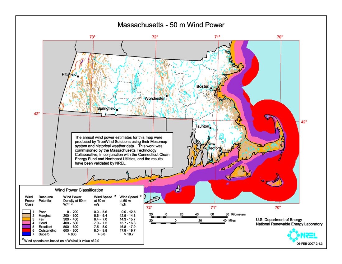
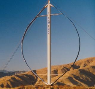
With Boston being the countries' windiest city, it would seem that wind power could be incorporated somehow into our building designs, doesn't it? I'm not talking about just sticking giant windmills everywhere, either. (Palm Springs,Cal scenery is destroyed, due to that aspect) But it would seem that with the multitude of technology rich center's of learning in our area (MIT,Harvard,etc.), someone could design a better looking way to harness wind energy, than with giant windmills. (???) Could windmills be small/hidden, as in an array of them hidden behind mesh/lattice (?) type material on top of a building?....I don't pretend to know the mechanics of wind power. If there is a minimum size unit needed to generate any sort of useful power effect, then my idea is probably useless. (especially when cost effectiveness is factored in)...food for thought, anyway.
 
A few things...

Where does is say Boston is the windiest city?

I would guess that making small windmills or blocking them with mesh would make their power output so low as to not be economically feasible.

This is't to say that buildings can't harness wind but it would have to be an added financial benefit. You want this on a mass scale you are going to have to start throwing down tax incentives. Wind should be expanded but the only way to make a serious dent is with big ass wind farms. I've seen my share and I personally think they are great and don't ruin vistas too much. But that is obviously just one man's opinion.
Boston routinely ranks as the windiest city in the country, easily surpassing Chicago by 2 mph for average wind speed.

http://technews.tmcnet.com/green/to...n-breezes-into-first-place-as-windiest-us.htm

Boston, Massachusetts (12.3 miles per hour)
Oklahoma City, Oklahoma (12.2 mph)
Buffalo, New York (11.8 mph)
Milwaukee, Wisconsin (11.5 mph)
Dallas, Texas (10.7 mph)
Kansas City, Missouri (10.6 mph)
San Francisco, California (10.6 mph)
Cleveland, Ohio (10.5 mph) , Minneapolis, Minnesota (10.5 mph), Virginia Beach, Virginia (10.5 mph), Providence, Rhode Island (10.4 mph)
Chicago, Illinois (10.3 mph)
Detroit, Michigan (10.2 mph)

Also, lapradetom, you might want to have a look at the shitshow of a discussion that happened in the 888 Boylston thread about wind power. 888 Boylston actually has turbines planned for the roof.
 
(Palm Springs,Cal scenery is destroyed, due to that aspect)

Having traveled in and around Palm Springs extensively, I find this notion curious at best. I have never heard anyone in Southern California complain that the San Gorgonio Pass windfarm bordered I-10 is "destroying" the views in Palm Springs.

Sure, you see the windfarm for a long time while you're driving on I-10 at 75 mph. But when you're actually in Palm Springs, in any neighborhood, how is it even visible? I've been in several Palm Springs neighborhoods and I haven't been able to see it.

I've also hiked Mt. San Jacinto and San Gorgonio, the two massive 10,000 ft.-plus mountains that create Palm Springs' valley (and incidentally serve as the most dramatic manifestations of the action of the San Andreas Fault, I would argue). The spectacular views at the top of both peaks are in no way compromised.

Do you have photographic evidence you would introduce to support this claim? Again, outside of shots taken from Interstate 10, when someone is doing 75 mph, which I would discount greatly. As far as I'm concerned, the 1000s of wind turbines serve as tiny pinpricks in the foreground of the stunning vistas of Mt. San Jacinto looming massively in the background.
 
Boston routinely ranks as the windiest city in the country, easily surpassing Chicago by 2 mph for average wind speed.

Side note, Chicago's moniker as the "Windy City" has nothing to do with meteorology. It refers to all the hot air spewed by its politicians. Now if only we could harness THAT!
 
Some large vertical axis wind turbines would look good on some of the otherwise butt ugly flat topped sky scrapers in Boston. Not sure about how cost effective they would be, but with existing subsidies it might work. Maybe generate a few megawatts each.
 
Boston isn't where the wind power is...Massachusetts Bay is.

Massachusetts_wind_resource_map_50m_800.jpg


It's the deep reds offshore where electric utilities see $$$ in profits. Especially because peak windpower on open water happens during daytime when demand is highest, and peak windpower on land happens overnight.

Now, the reason why Cape Wind was such a torturously expensive endeavor--beyond the NIMBY's and Kennedys who tried to kill it--is that a first-time installation is crazy-expensive. You need to lay the trunk cables, and you need to buy a specialized fleet of service boats to get out and maintain the turbines. But once those up-front costs are put down an incremental expansion off an existing installation or chaining of new installations together gets progressively less expensive. So every additional wind farm after Cape Wind gets easier.

Now wait till they start building farms inside of the Bay between Plymouth and Ptown in those shallow waters only a few miles offshore. Or on Stellwagen Bank only 25 miles due east of Boston where the water depth shrinks around the underwater plateau is only 100 ft., middle-middle range depth for a typical large offshore wind farm.


It's not even going to be worth it to start ringing the Harbor Islands with turbines with a large installation when you can get at least 3x that a few miles further out. It's not a question of if...it's when. There's a certain logistics buildup to be able to go large-scale out in the water, and that means a slow start. But the profit margins offshore are so insane we're eventually going to have the whole Bay ringed by turbines.
 
Now wait till they start building farms inside of the Bay between Plymouth and Ptown in those shallow waters only a few miles offshore. Or on Stellwagen Bank only 25 miles due east of Boston where the water depth shrinks around the underwater plateau is only 100 ft., middle-middle range depth for a typical large offshore wind farm.

I have wondered why there isn't more wind generation here in Provincetown, since it is easily the windiest place I have ever lived!

I don't think you'll be seeing turbine built in the shipping channels or the Stellwagen Bank Marine Sanctuary, though. And I'm sure the property owners on Cape Cod Bay would balk at the idea of clogging up their views with turbines -- didn't we already go through that on Nantucket?

I agree that Stellwagen's going to be difficult. But it'll also be the very last area anyone wants/needs to tap since Mass Bay has shallower water.


Cape Wind NIMBY's will (and to some degree have) learned that it's not the end of the world. There have already been other wind farm proposals down there that have survived past the initial approval stage without nearly the drama of Cape Wind.

As for Ptown, they have peak wind power and shallow water so far out in the Bay that it's unlikely the Cape NIMBY's will even be able to see where they're installed. I would think they'd stick closer to the Plymouth side of the Bay anyway because the feeder tie-ins are so much easier on the mainland with Pilgrim nuke's lines right there. Hell, Plymouth will welcome the farm with open arms if it's another reason to pressure the NRC to close Pilgrim for good. That'll both secure the community support and get the wind companies scrambling for that offshore license.
 
DBM....I can't discount your claim that Palm Springs' views haven't been harmed in other areas of the city by the windmills that run along I-10, because I am not a resident, and have only driven through-along I-10. But my eyes did not deceive me when, as you state yourself, you see countless windmills as far as the eye can see, for miles. Given the natural beauty of the area, to me it looks like a man-made disaster scene. I was shocked at how bad the hundreds (?) of windmills made the drive through look. As a nationwide/over-the road truck driver, I've seen every state, and the windmills don't look bad on the praries in the Midwest. Really hard to put into words how they look, because they are so large and just dominate the scenery wherever they are placed. Actually sort of a beauty to them in certain settings. But I really thought they ruined the scenery driving through Palm Springs. I guess it's the tradeoff to harness wind energy. Sort of like putting a huge dam somewhere. China flooded a huge area for the Three Gorges Dam. Spectacular habitat/scenery flooded to make way for hydro power.
 
On second thought, I retract any and all ideas of utilizing wind power on top of Boston towers....I forgot all about Harbor Towers, and how it may impact the residents in some way!
 
I just thought some vertical axis turbines would be like putting lipstick on a pig for some of Boston's towers (plus a little bit of electricity).

Take the tombstone of a tower that is One Boston Place and imagine one of these on top. Yes still ugly, but now it is ugly and has a spinny thing on top:

flowind_darrieus.img_assist_custom-320x300.jpg


On the top of this:
800px-One_Boston_Place_%28Boston%29_Solarapex.JPG
 
Honestly, nobody's going to care if a skyscraper has turbines on top. Skyscrapers have cell phone towers on top, and people thought those were ugly as hell a dozen years ago when they started going up. If it helps just a little bit to lower the building's day-to-day energy costs they can slap as many spinny things and solar panels as they can cram on there. It's gotten to the point where private enterprise is self-motivated to seek out every little utility cost offset like that, so we're going to see more of this like it or not. Everybody's got to do their part to minimize carbon footprint...including one's own sense of aesthetics.


But minimizing a building's carbon footprint through LEED certification on new construction and retrofits on old isn't at all the same thing as changing the % makeup of renewables on the grid itself. Sticking a turbine on a building or on a useless plot of land next to an offramp is carbon footprint reduction. It's nice for taking a little edge off the top, and it optimizes land use. There's good reason for doing it, and doing more where that came from.


Offshore wind farms are the only power source with that hugely game-changing a potential for New England. And legitimately huge it is. You're talking generation capability that serves near-100% of the Cape and Islands (Cape Wind alone takes a quarter chunk at just the initial base build), 30-50% of Plymouth and Bristol counties, 15-20% of Metro Boston, and 25%+ of Metro Providence. Just in Cape Cod Bay, just in Massachusetts Bay. And...setting aside the thornier environmental protection issues, just in the parts of the bays that aren't federally designated wildlife areas.

The way I look at it, all the pain and suffering and cost overruns and shouting about boondoggles in getting Cape Wind to the point of breaking ground were worth it if it starts that scale-up. The first one is always going to have tons of sunk cost associated with it: feeder cables where none previously existed, specialized fleets of maintenance boats and onshore maint facilities where none previously existed, establishing supply chain, etc. And then all of the human sunk cost of dealing with skeptical local regulators sticking their fingers all over it, the hysterical community input, and generally teaching people that this isn't some sort of voodoo.

Once you get that Ground Zero generating farm established it gets way easier to add scale...and add it drama-free. The farms can get chained together, and eventually have redundant feeders geographically placed to enable still-easier chaining. The maint fleets and shoreline facilities are pre-existing; it gets easier to bring in more boats, more staff (and yes, utilities operating different farms will pool their dockside resources in the early going for scale). The local regulators are a little bit better-educated the second time around. And when the world hasn't ended and beachfront property owners' view of Venus hasn't been obstructed and their National Grid bills come way down hysteria begats more muted fidgetiness begats general acceptance. And then the only screaming you hear are the Old Man Yells At Cloud types who scream at everything.

Scale, scale, scale. Slowly rising scale. And that's exactly how it's unfolding with the follow-on proposals to Cape Wind to start sticking more farms along Buzzards Bay, further offshore of the Islands, and making the first foray north of Cape Cod Canal into Mass Bay. The shitshow on Cape Wind was the necessary trial everyone had to go through. Every party banking on it knew it was going to be a shitshow, knew it was going to involve a lot of sunk cost and ill will. Because that's always how it goes the first time around, and those who have been around the power industry--on the private side or the public/regulatory side--long enough are well aware that this is S.O.P. for a first-time rollout of an unfamiliar power source in a new area. They're the shock troops. They subject themselves to being the shock troops because there's profit in it in the end.

That says all you need to know about the enormous offshore wind capacity in New England. The industry and the public officials who were up on the industry were willing to take on a surefire shitshow like Cape Wind and all the political risk associated with it for the sake of the build after that, and the build after that. They don't do that for novelties. They do it because the scale is that good. So can't read too much "Big Dig Syndrome" into the Cape Wind experience, because the private side fully baked that in as a normal cost of doing business and the (lucky few) less-flaky political forces who were in it for the long haul educated themselves well enough to know patience would be rewarded.
 
Having traveled in and around Palm Springs extensively, I find this notion curious at best. I have never heard anyone in Southern California complain that the San Gorgonio Pass windfarm bordered I-10 is "destroying" the views in Palm Springs.

Sure, you see the windfarm for a long time while you're driving on I-10 at 75 mph. But when you're actually in Palm Springs, in any neighborhood, how is it even visible? I've been in several Palm Springs neighborhoods and I haven't been able to see it.

I've also hiked Mt. San Jacinto and San Gorgonio, the two massive 10,000 ft.-plus mountains that create Palm Springs' valley (and incidentally serve as the most dramatic manifestations of the action of the San Andreas Fault, I would argue). The spectacular views at the top of both peaks are in no way compromised.

Do you have photographic evidence you would introduce to support this claim? Again, outside of shots taken from Interstate 10, when someone is doing 75 mph, which I would discount greatly. As far as I'm concerned, the 1000s of wind turbines serve as tiny pinpricks in the foreground of the stunning vistas of Mt. San Jacinto looming massively in the background.


Nicely done. San Gorgonio Pass is varies from pathetic to horrific dustbowl. You want to be as far as humanly possible from what is little more than a very well utilized (I-10/UP mainline/4000 turbines) corridor turned into a wiindy nightmare for 20 hours each day. You couldn't pay anyone in their right mind to live in this hell hole. But, homes are being built in the pass, within only a few hundred feet of the turbines. Insane.

https://www.google.com/maps/search/...16.7181539,454a,20y,8.9h,71.36t/data=!3m1!1e3
 
Last edited:
Nicely done. San Gorgonio Pass is varies from pathetic to horrific dustbowl. You want to be as far as humanly possible from what is little more than a very well utilized (I-10/UP mainline/4000 turbines) corridor turned into a wiindy nightmare for 20 hours each day. You couldn't pay anyone in their right mind to live in this hell hole. But, homes are being built in the pass, within only a few hundred feet of the turbines. Insane.

https://www.google.com/maps/search/...16.7181539,454a,20y,8.9h,71.36t/data=!3m1!1e3

So fun to click that link and zoom out to remind oneself of that stunning landscape.

Despair as one may in the works of humankind, as it continues to junk up the scenery with cheap cookie-cutter tackiness, but take solace in John Muir:

"In the mountains of San Gabriel, overlooking the lowland vines and fruit groves, Mother Nature is most ruggedly, thornily savage. Not even in the Sierra have I ever made the acquaintance of mountains more rigidly inaccessible... the whole range, seen from the plain, with the hot sun beating upon its southern slopes, wears a terribly forbidding aspect. There is nothing of the grandeur of snow, or glaciers, or deep forests, to excite curiosity or adventure; no trace of gardens or waterfalls. From base to summit all seems gray, barren, silent -- dead, bleached bones of mountains, overgrown with scrubby bushes, like gray moss. But all mountains are full of hidden beauty, and the next day after my arrival at Pasadena I supplied myself with bread and eagerly set out to give myself to their keeping."

End of thread derail.
 
So fun to click that link and zoom out to remind oneself of that stunning landscape.

Despair as one may in the works of humankind, as it continues to junk up the scenery with cheap cookie-cutter tackiness, but take solace in John Muir....

#La Jolla; I attended Muir. :)

One last before we go; i've driven through the pass many times in the past couple of years commuting between LA and Phoenix.... i'll show you the 1 must stop in the area; a real gem. You'll save yourself an asston on groceries, and there's nothing fresher in the valley. This is where you stock up when heading into the LA basin or the long journey back to Boston; one of the best in S. Cal!!

https://www.google.com/maps/place/D...7bd0add66bfec!8m2!3d33.9316358!4d-116.9970124
 

Back
Top