General Infrastructure

Wow, has it been that long? I guess it just feels like it just finished.

Thanks!
 
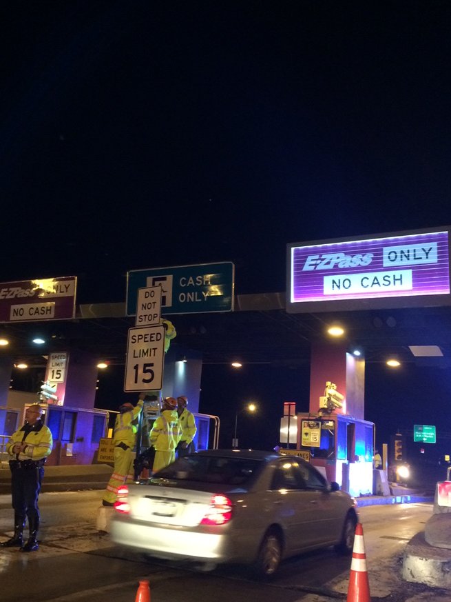
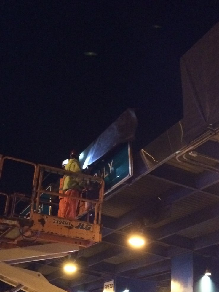
10 PM - AET/ORT has officially begun on the Mass Pike, Tobin Bridge & Tunnels (Bridge & Tunnels both directions now)

https://www.massdot.state.ma.us/highway/TollInformation/AllElectronicTolling.aspx.

https://twitter.com/MassDOT

"Do Not Stop"

Cv5p2PNUIAAYUE3.jpg:large

MassDOT Twitter

Goodbye "CASH ONLY"

Cv5rGcQVMAAzUq7.jpg:large

MassDOT Twitter
 
Last edited:
One thing I think about a lot and have never heard of a plan for is a way to connect more streets that cross the ciity from side to side. There is literally only mass ave. Malcolm x blvd sort of does too so Ill throw that one in there but thats about it. The trains, highways, and roads all lead downtown. You have to head downtown before you are able to head off in whatever direction you need to go. This obviously creates an unnessecary clusterfuck of traffic on already tangled roads and the end result is a mess. That or you have an extra 30 minutes on your train ride heading the wrong direction before your finally on your way.

I know the inner loop and urban ring were cancelled, but what now? 95 is too far for an effective cross city route and so you either sack up and take mass ave, meander along some random side streets, or head downtown. This is a huge detriment to transit in the city. I live in dorchester and when I need to go to waltham I can either take the red line in the opposite direction than that of which I need to go before looping back and stopping at central sq to hop a bus, hate life on mass ave to get on the pike, or park on 93 tip toeing downtown before I finally get to the pike.

There is a commuter rail at jfk but guess what north and south stations arent connected so no reason to take that over red. I can swear 2,974 times on the one cross city road-mass ave to get to the pike, or I can get on 93 towards downtown bedore doing a 180 and heading the actual direction I need to go.

I know theres not going to be a new highway built but on google maps it seems like theres a few places that roads could cross the orange line trench to connect the city better. An inner ring subway is going to be a necessity some day, even with our fondness of new tunnels, but what else can we do?

Boston has grown a whole lot and I think were buying on credit right now. I think there needs to be a complete citywide reevaluation and address of some glaring issues.

Hundreds of roads can be made two way streets as probably the simplest first step. Then we probably should build some bridges over the orange line and fix that hole in the grid. After that it gets messy but we may need to tunnel. Also going back to the argument about the nsrl getting from dorchester to waltham would be a whole lot easier for 1 example. What else do you guys think can be done because this problem isnt going away and its getting worse every year. If you really look at it its about the least efficient system that you could have. Send everybody right into the middle of downtown before they can head off in whatever direction they need to go. Theres gotta be a better way and I think it starts with the orange line trench and more two way streets. What do you guys think?

Edit: melnea cass ending at columbus ave is the most glaring example. Cross half of the city just to be fed right into a road that heads straight downtown. You can turn onto tremont but thats where the orange line trump wall + general clusterfucketry of roads really shines. Hell even the last time I went to visit my buddy in Brighton it was too late for the t so I decided to make the cross city trek by car to avoid tolls and it was a friggin joke. Theres gotta be a better way. I dont own my apartment but id give that thing up to eminent domain in 1 second if it meant a cross city road could go in. Theres plenty of triple deckers to go around.
 
Last edited:
Stick -- Have you tried to go across Melnea Cass then Tremont to Ruggles Across Huntington then via Louis Prang to the Fenway and then either the Riverway or Storrow

I've a business associate who lives in Brookline near Longwood, and sometimes when we need something which we can get at Home Depot, we go to South Bay via some of that route. Sometimes we make a major excursion on the way back taking Route 9 [Huntington Ave] through Brookline to get to someplace westish such as YouDoit in Needham/Newton area.

Coming from Lexington via Cambridge I often Exit Storrow through the infamous Bowker Interchange and from there its easy to connect to the Fenway, Riverway, Comm Ave, Boylston St., Huntington Ave., Mass Ave., network -- this route usually works quite well when I'm driving to/from Lexington to say the MFA area or to Kenmore.

Specifically, I think that you need a better GPS or use Google Map's "Directions" function

In general, you do bring up some bigger issues involving limited places to cross the Orange Line or even the Huntington ave branch of the Green Line. However, Rather than building new streets or even redirecting existing streets -- mostly what is missing is better information [hopefully up to date] on which streets to take. While routing through Boston may not be obvious, as it would be in some midwestern city with a perfect rectangular grid going on from Horizon to Horizon -- Boston's circumferential and radial structure still has worked well enough for generations.
 
Stick -- Have you tried to go across Melnea Cass then Tremont to Ruggles Across Huntington then via Louis Prang to the Fenway and then either the Riverway or Storrow

What you just typed is exactly what Im talking about. Theres only a couple ways to get across the city and all but 1 are a beligerant clusterfuck. That 1 being ass ave and its still a clusterfuck but its 1 road. Getting downtown is easy you basically just get on any road and drive east. People that dont even want to go downtown still have to go there to get to where theyre going so if there were more options for people to drive north-south downtown wouldnt be as crammed...seeing that basically everyone has to pass through it at some point during the day.
 
What you just typed is exactly what Im talking about. Theres only a couple ways to get across the city and all but 1 are a beligerant clusterfuck. That 1 being ass ave and its still a clusterfuck but its 1 road. Getting downtown is easy you basically just get on any road and drive east. People that dont even want to go downtown still have to go there to get to where theyre going so if there were more options for people to drive north-south downtown wouldnt be as crammed...seeing that basically everyone has to pass through it at some point during the day.

Stick -- I agree that the proverbial Golden Opportunity was blown when despite all the Expansion of the Scope of the project that the BiG DiG couldn't find a way to add a couple of ramps to the Pike.

The ability to enter the Pike at Alston / Brighton from Storrow heading East and get off in Southey or Logan circumventing the need to go downtown is the single greatest achievement of the Big Dig. That single change in traffic patterns made the pain and suffering of the project worthwhile.

However, the BiG DiG's greatest failure was / is the need for the Slingshot for busses and cabs trying to get to the Back Bay hotels from the BCEC. The alternative being to go all the way to the Museum of Science on I-93 to catch Storrow Drive heading west. It would have made E-W travel so so much better if you could get on the Pike at say the Pru heading E to Southey or Logan. And if you could get off the Pike somewhere from South Station to Kenmore while heading west from Southey or Logan that would have been Nirvana.

While I do think that an opportunity was missed in not connecting Melnea Cass to Huntington, I don't share your concern about the need for many more crossing routes further south. This may be because, as I previously posted, on the rare occasions when I've taken the Fenway to South Bay trek its worked OK.
 
^ this isnt a jab but if you live in lexington thats why you dont notice. This shit kicks my dick in every single day. Most of the time you just have to sack up and take 93-90 and its a fucking parking lot 14 hrs of the day. Getting to anywhere west of downtown from dorchester, southie is a joke.
 
While coming back from Logan today, I saw the progress on the tollbooth demolition.

Allston had about 10 excavators lined up ready to go but no physical progress yet.

Weston was flying. I was shocked to see them already paving near liberty mutual. Also the middle toll booths are already basically gone. They looked like they were already filling in the tunnel with dirt. That was much faster than I expected.

Demo Phase I must be complete within 30 days of yesterday or there are very serious penalties. They aren't wasting a second. MassDOT of course wants to have traffic flowing thru the middle at higher speeds (more than 15 mph) sooner rather than later too so they can start Phase II and be done by the end of the year deadline.

From @MassDOT:

CwCBGjcXgAA-jxm.jpg:large


CwDvq7MXEAEho_A.jpg:large
 
I am sure the upcoming Thanksgiving holiday is also another reason for the haste in getting the tollbooths gone.
 
I am sure the upcoming Thanksgiving holiday is also another reason for the haste in getting the tollbooths gone.

I think the deadline is to have it ready before the travel weekend
 
There weren't even traffic backups this morning at 15mph, contrary to traffic apocalypse predictions from MassDOT. Once this whole thing is complete and flowing at 60mph, Pike traffic should be significantly improved.

From @MassDOT:

Video of (former) Weston tolls:
https://twitter.com/JacqueGoddard/status/793056442009939973

Framingham:
CwGSxsCWgAASyEB.jpg:large


Natick:
CwGPHK4WEAUFGKH.jpg:large
 
Last edited:
So are they leaving the booths in place at the entrance to the Sumner? Looks that way from the prez, but it only shows 'Phase 1' - no 'Final'.

Leaving them there would seem to be the best option. That stretch of road is totally unique - you have a street-level city intersection, the highway, a lane drop, a 90-degree left turn, pedestrian crosswalks....and it definitely has it's own 'culture' in terms of the 'unwritten rules' of how the merge works at rush hour. I just can't imagine that place being anything close to safe - or even functional - as 'open road' without a complete (and nearly-impossible) re-build of everything between the Logan ramps and the tunnel portal...

You make it a lot safer by funneling it. Basically making it a couple through lanes from 1A and an entry merge. Most of the tarmac gets cordoned off. The fan out and remerge is the safety issue.
 
I dunno, I think it's different here...you have traffic merging from three city streets with almost zero merge distance, and both of those sources intersect at grade with traffic exiting the highway. You're going from 3 highway lanes + 3 entrance lanes to 2 tunnel lanes in about 200 feet, and there's the at grade intersecting exit to contend with too....all on top of a 90 degree left hand turn that would be considered dangerously abrupt for a bike path, let alone a highway...

Actually now that I'm thinking about it...I guess you could throw a little roundabout on the central square side of things and have it feed a single merge lane, but I don't expect that's in the cards ...
 
All of the tolls have a ton of closeout work to manicure the asphalt into controlled-access roads and not a giant tarmac. That's going to take a couple years at least to erect permanent structures. They just want to blitz any traffic-harming effects of the changeover right now, because once you have a flat tarmac of pavement you can lane-shift to your heart's content for jackhammering medians, erecting barriers, and narrowing the excess width into regular old travel and merge lanes.

Gonna be a couple years of traffic cones, temp jersey barriers, and troopers handing out tickets in order to corral traffic through all these empty tarmacs before we see final form take shape. And the Sumner has all that torturous abutter and City input to go along with its eventual reconfig, so they're not going to waste any time getting yelled at by old men in Eastie meetings so long as they've got umpteen Pike interchanges on their plate to nip/tuck.

It'll get done, and it'll eventually be a lot nicer-arranged and safer than the booth sprawl and 90-degree angle that currently ruins that whole neighborhood. But it's the last one they want to waste excessive bandwidth on up-front.
 
So are they leaving the booths in place at the entrance to the Sumner? Looks that way from the prez, but it only shows 'Phase 1' - no 'Final'.

Leaving them there would seem to be the best option. That stretch of road is totally unique - you have a street-level city intersection, the highway, a lane drop, a 90-degree left turn, pedestrian crosswalks....and it definitely has it's own 'culture' in terms of the 'unwritten rules' of how the merge works at rush hour. I just can't imagine that place being anything close to safe - or even functional - as 'open road' without a complete (and nearly-impossible) re-build of everything between the Logan ramps and the tunnel portal...

There is a larger project for this intersection that involves making it much more compact and adding greenspace, height detection infrastructure, etc. Last I checked it is still being designed, so that is probably why there are no materials showing the final condition.
 

Back
Top