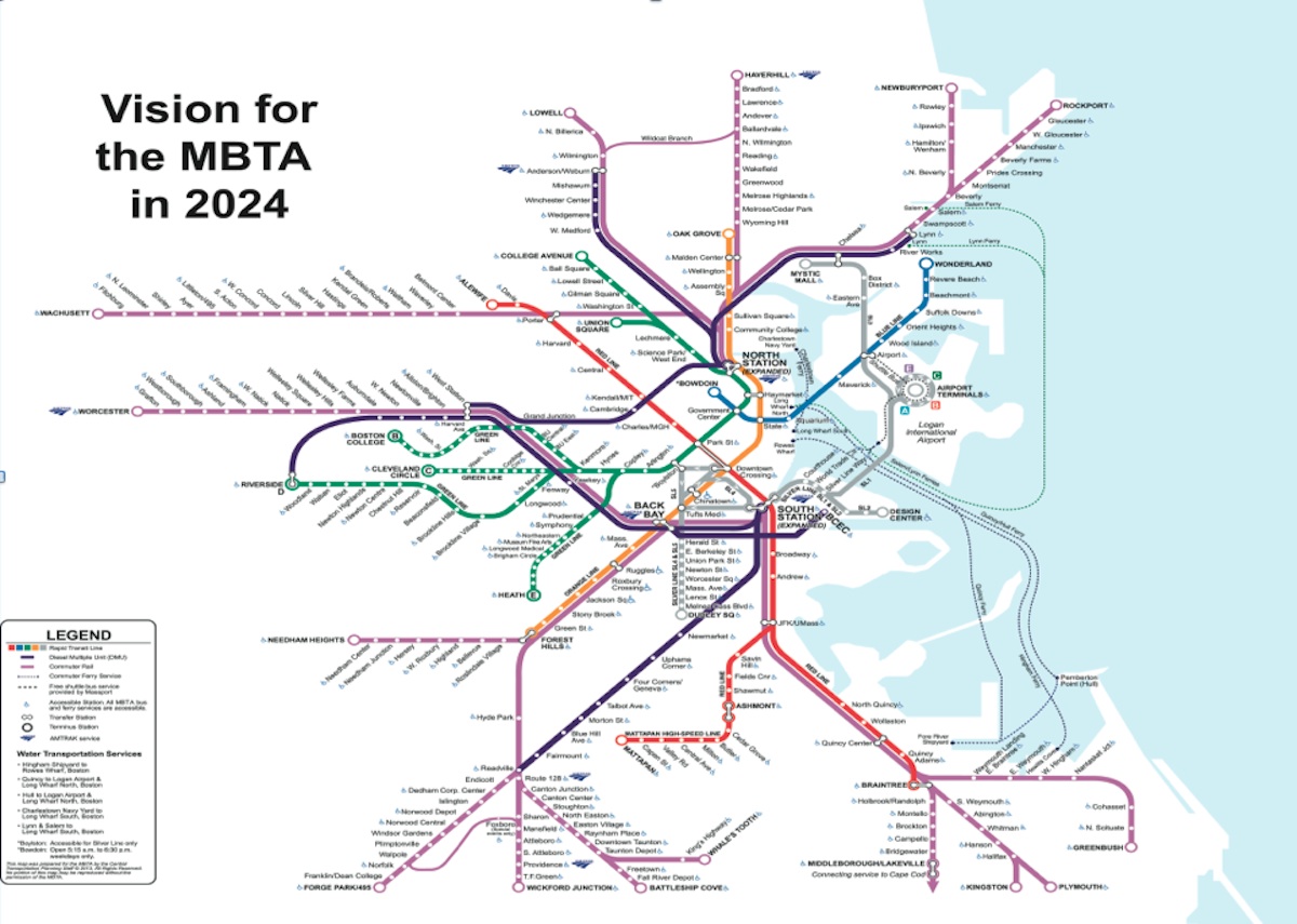
Yep, 17 minutes for a 5-mile trip with several S curves. Ashmont-Milton-Mattapan-Fairmount is another 4 miles, with roughly the same station spacing and a couple more curves. Contrast that with Braintree, which is straighter and has a 4-mile nonstop section.
17 + (.8 x 17) = 30.6 minutes, plus peak-load padding. I grant it'd ultimately be closer to 30 minutes than 40 minutes, but it's still a lengthier trip that takes you to the same place an Indigo Line would: South Station.
My point (even with the lower travel time estimate) is that the difference between 6-minute headways on a 30+ minute journey vs 10-minute headways on a 25-minute journey is not astronomical. Yeah, it's not trivial, but it's not huge. Which is why this proposal is "meh" in my eyes.
Urban Rail ops do
15-minute bi-directional frequencies, not 10. So max Fairmount frequencies are a 9-minute difference from Red branch frequencies, not 4 minutes. That's a much more significant gulf to contend with, and it changes the calculus a lot on the travel time vs. frequency balance.
The only places on the Purple Line where local-stop train frequencies will outstrip 15 minutes are in the terminal district, which you may as well lump Ruggles inside of going forward since there'll only need to be a few select Providence skips per day in the name of Amtrak avoidance. *Maybe* a Peabody-fied Eastern Route undercuts the :15 average at some stops with 3 branches churning, but most likely you'll see a skip-stopping load balance act on the Rockburyport schedules to speed things up while keeping Salem-inbound local stops in equilibrium at :15 and adding more infill stops. *Maybe* Anderson Station also sees sub-:15 frequencies because when NHDOT builds out to Concord they plan to run the end-to-end service as a wholly separate (and probably smidge less frequent) schedule from the T's Lowell/Nashua-terminating locals, picking up all local stops in NH but expressing in MA serving only Lowell, Anderson, and North Station. Thus, that stop may see periodic spikes of more frequent service...though not necessarily anything dramatic.
But things like Urban Rail to Riverside are not going to interline with long-haul Worcester RER service, which needs to skip nearly all of Allston-Newton to make tolerable time to Worcester. And you're certainly not going to see major backfill anywhere else challenging the :15 floor because load-balancing cushion on such a dispatching-complex system will be paramount. So if frequencies still weight much heavier to generating demand than the one-seat or raw clock time when all else is equal, you'll pretty much never see a situation where Urban Rail is preferable to full rapid transit. And that becomes especially true if the transfer at SS to a Transitway-Downtown light rail connection is completely inside the prepayment area instead of requiring tap-on/tap-off and the uncertainty of the T being able to implement an RER-to-rapid transit transfer fee whenever it wants if budget crises warrant.
The reason you have Urban Rail on Fairmount and not a rapid transit proposal is that we made a deal-making promise not to sacrifice the last direct freight route into Port of Boston because 100-year sustainability considerations rule an instant-gratification mode grab unwise enough that instant-gratification pols have to be legally barred from it. Therefore Urban Rail is the best you can do on the whole of the corridor...in similar vein as Urban Rail is the best you can do on the B&A through Newton with the Pike permanently cannibalizing half the ROW, and that no-Urban Rail/yes-Rapid Transit is the only equitable way to give the Needham Line corridor service around the permanence of the SW Corridor capacity constriction.
The only exception is Hyde Park, because the area south of River St. to Readville was once graded for 4 tracks due to extinct freight sidings. The only reason you'd consider Red is because Orange can no longer be done on the NEC. The only reason the build itself is non-crazy on price is because a station-less subway tunnel between Mattapan Sq. and Poydras St. anchored in hard granite seam either under River St. or deep-bored straight under property lines comes out well to the reasonable side for any kind of digging in Boston-proper. And it doesn't blow Red Line ops out of balance in any meaningful way to cause concern with branch management.
As for the math:
You'll need to refactor Braintree with the Port Norfolk infill stop. That's going to be built long before you ever consider Hyde Park. With PN the largest station gap on the Braintree Branch becomes 2 miles: JFK-Port Norfolk. On the rest of the branch it's 1.5 mi. (PN-N. Quincy), 0.8 mi. (NQ-Wollaston), 1.2 mi. (Wollaston-Quincy Ctr.), 1.3 mi. (QC-Quincy Adams), 1.7 mi. (QA-Braintree).
Average: 1.4 mi. Wider spacing than the other lines, but no longer the extreme outlier with its most pregnant omission plugged.
Extending out of Ashmont the distances would be 1.3 mi. (Ashmont-Milton), 1.3 mi. (Milton-Mattapan), 0.9 mi. (Mattapan-optional
River St. infill), 0.8 mi. (River St.-Fairmount), 1.2 mi. (Fairmount-Readville). Average:
1.1 mi. on the extra stops. Average for existing Ashmont Branch:
0.7 mi. Average combining existing Ashmont Branch with Readville extension stops:
0.9 mi.
What's remarkable is how little the needle gets pushed by the extension. And since it's acceleration/deceleration where the biggest performance boost is going to come from all the lineside improvements to Red, the Ashmont Branch sees a comparably bigger performance boost. As per my last post, if a wide discrepancy opens up between branches you swap Savin Hill over to the Braintree side to keep things in balance...but I don't even think further continuation to Dedham ends up forcing that trade.
Fairmount-Mattapan-Ashmont-JFK/UMass is about 7 miles of track. About half of those are traveling east-west. South of Ashmont especially, you've essentially got a dog leg. It's a less direct route between South Station and Fairmount, and thus takes on some qualities of a circumferential. Not that that's per se a bad thing -- SL3 does the same thing in Chelsea, and that's clearly the best route absent an expensive Tobin rework.
Not the same. The Red Line is a thoroughly through-the-gut operation. SL3 cobbles together some flotsam that's going to someday be repurposed into a from-the-ground-up radial in the form of the Urban Ring. The travel patterns are what makes a line radial vs. a spoke. Riverbank geography doesn't suddenly turn Red into something it's not as the ridership patterns are still going to tilt overwhelmingly to/from the gut.
(And, as you say, if Red were to continue on to Dedham, it would likewise become more of a circumferential. In an RER future with a Red-to-Dedham extension, I'd expect most Dedham commuters to transfer at Readville to an NEC express service, whether going to Back Bay or South Station.)
At 6-min. frequencies behind prepayment, or at 15-min.? I think this Dedham leg is out-of-scope because intracity comes first and Dedham is a weird anti-transit land that doesn't seem to want things all logic says they should want. But even with their weirdness, are they really going to buck established human behavior when it comes to the primacy of frequencies dictating where the ridership goes?
Even though Providence + Stoughton (if you can salvage any intracity stops on a South Coast Rail schedule that currently projects to skip them) combine to make good frequency (if maybe not :15 on-the-button) and all manner of traffic on Fairmount/Franklin combine to make :15 exactly on-the-button...it's not like you're just adding up the NEC and Fairmount platforms together to net 7.5 minutes. The platforms are far apart, and two routes under two different dispatchers are working the lines. Between scheduling convergence and simply counting the footsteps to transfer, it's not in real life going to be the superduperstation that Jamaica on LIRR is. You'll be guaranteed a :15 in the Fairmount direction, a good-ish if meandering frequency on the NEC (still can't see every single Providence/Stoughton slot making it even if most could), and the occasional lucky timing where inbound arrivals on separate platforms are spaced enough to give you a momentary sub-:15 headway. But it's still not the same as 6 minutes on rapid transit that avoids an unfixably sprawly station setup.
My point is that a Red Line extension to Hyde Park would certainly improve frequencies, and isn't per se a bad idea, but that it doesn't address the only real drawback of RER, which is the loss of direct access to areas west of Downtown. If money is to be spent on tunneling etc., I think it's fair to suggest that it should do more than duplicate other service but with worse travel times.
RER creates some minor losers amongst winners. NSRL does that even moreso. The spoils are distributed far and wide to great effect, but there are microcosms where that's not going to be true. Hyde Park Station is one of those. The Needham Line: whoooo-boy that's one of those if we find ourselves too cowardly as a state to do that rapid transit conversion.
No doubt this is going to cause some fear and hand-wringing...in those microcosms. But I have to shake my head at the number of times I hear the sky is falling on aB because one-seat to Back Bay is in question. Or that everything not being routed through Back Bay and Kendall means the city is going to collapse into a gravitational singularity. It's not physically possible to give BBY one-seats to everyone, every time. It's not possible to give everyone the absolute bestest time-on-clock, every time. But it IS possible to pump up frequencies into the CBD, find offsets for some of the inequities, and offer up a variety of solutions for a neighborhood. For example, Needham Line conversion isn't just about Orange or SW Corridor; the ability to turn local buses at a Rozzie Sq. transfer enormously improves neighborhood transit, enormously improves traffic on Lower Washington out of Forest Hills, and enormously improves the congestion at FH that's slowly choking the terminal to death. But if we're so squeamish that the Orange Line takes longer on a stopwatch to get to Back Bay Station than the absolutely broken-and-unimprovable CR frequencies...who's looking at aggregate improvements? That energy is all getting sucked up by Back Bay theoreticals. It can absolutely kill RER dead if those obsessions of theoretical losses take bandwidth away from finding aggregately better solutions.
(Though it would be fair to point out that a Red extension would offer a one-seat ride between Cambridge and Hyde Park -- that'd be fair.)
Now...since it's bottom-barrel on the priority pile, analyzing when things like this start to become a driver in the neighborhood can chart its rise off the bottom of that pile. Realistically, it's nowhere near strong enough a draw in the forseeable future. But consider NSRL being able to pair-match Fairmount with something up north. Unless that northside something is the Fitchburg Line hitting Porter, Cambridge isn't a place they'll ever see without transferring to Red. And Fitchburg is the MOST geographically awkward of the available northside pairings, so it's more likely to be Reading or Lowell drawing that assignment. OK...now you've got somewhat of an inequity post-NSRL leaving an itch to scratch. Does that lift a Red Mattapan-HP off the bottom of the pile?
I won't speculate if after that cosmic realignment it's got enough juice to possibly proceed, but its chances probably get better when NSRL itself isn't enough (because of those chance inequities) to put Cambridge jobs in adequate reach.
Yeah, there's no disagreement here. The schedule from downtown definitely will be worse on a Red Line extension, but it won't be unusable. But it's a middling pitch. If you want to extend the Red Line past Mattapan, I think it's a stronger argument to position it as the first phase of an extension to Dedham, Roslindale Village (via Cummins Hwy, absolutely a crazy pitch), Route 128 or somewhere on the Franklin Line.
As above, schedule difference is much more muted than you initially factored.
There isn't a lot of Crazy Pitching possible here. It's pretty much tunnel under River St. or deep bore using the favorable bedrock and lack of in-tunnel stations to keep cost down, then quad up the Fairmount Line from the first Neponset crossing to the existing commuter rail yard. Then hop across to go to Dedham Ctr. on the grade separated branch.
- Cummins Hwy. gets too narrow by the cemetery and densely abutted in Rozzie to be of use. Becomes "hard" tunneling the likes of which we have to avoid in the city to steer clear of major cost blowouts. Try BRT. Or a Blue Hill Ave. + traffic-calmed Morton St. trolley to Forest Hills, which might be a solution to the problem of trying to force-fit a Dudley-Mattapan streetcar on much narrower streets.
- 128 isn't reachable to the south on rapid transit. 4 track berths on the NEC ROW are all claimed to Westwood for Amtrak + RER traffic increases, and there's water on both sides of the trackbed prohibiting any further expansion. Franklin main is on an unexpandable 2-track swamp embankment between Endicott and Dedham Corporate that's also cosmically no-go on EIS'ing. Dedham Corporate WILL, however, get :15 frequencies thanks to Forge Park + Foxboro interlining. If Forge Park needs to run skip-stop for sake of end-to-end travel times, it also isn't a big deal to send a Fairmount short-turn local to Corporate to preserve the headway.
No paths left to speak of with all that struck down...just your typical Civil Engineering Strongman stuff that's more meant to be admired on Google Map Maker than spoken of in terms of future feasibility.
") 15 inner/:30 outer) is what all the capital outlays for adopting RER in the first place are about, and the only thing we need to be concerned about right this second as they mull adoption.
15 inner/:30 outer) is what all the capital outlays for adopting RER in the first place are about, and the only thing we need to be concerned about right this second as they mull adoption.