You are using an out of date browser. It may not display this or other websites correctly.
You should upgrade or use an alternative browser.
You should upgrade or use an alternative browser.
MBTA Construction Projects
- Thread starter justin
- Start date
CyclistAlan
New member
- Joined
- Mar 2, 2020
- Messages
- 10
- Reaction score
- 4
How will PanAm access the tracks on the NewburyPort/Rockport line from the Yard 10 lead and Yard 21 storage tracks?
THX,
Alan
THX,
Alan
CyclistAlan
New member
- Joined
- Mar 2, 2020
- Messages
- 10
- Reaction score
- 4
How would any of these possible other location options for PanAm to store and sort rail cars work (compared to Yard 21 lead tracks): https://flic.kr/s/aHsmN49zU8? THX.There is absolutely NO co-existence of different modes on same track...never ever. It's not only FRA-illegal, but the wheel profile of a rapid transit car is ground differently from a RR car so the trolley wouldn't hold to the rails for very long on RR track without derailing.
Access to the carhouse is reducing the number of thru RR tracks around the backside of Boston Engine Terminal to the BET driveway grade crossing off 3rd Ave. to create ROW for the carhouse. Access will come off of the Brickbottom junction flyovers and overpass a couple RR tracks to get there. Freights and non-revenue passenger moves will have 2 fewer tracks to work with behind BET, but will have the same access points from multiple sides as before. The Yard 10 leads by Sullivan have switches tied into the area of the freight wye; it's some distance away from where everything GLX-related stops.
There will be no track connection whatsoever between any GLX trackage and any RR trackage. They are completely 100% separated by fence and never interact. The only Green Line track connection to the national rail network remains at Riverside spur off Worcester Line's Riverside Jct. It's so extremely seldom used even for work equipment transfers that there's zero need for a second connection at BET.
The Yard 10 leads measure out to whatever Google's measuring tool says it is. It's configured so the single-track switch before Assembly end-of-track can runaround (change ends) for a 3-locomotive lashup. Crossover switches TBD scattered on the mid- or third- points on the whole length of double-track allow Pan Am to switch in/out strings of cars. Car storage is more or less equivalent to the Yard 8 it replaces, but switching space is more constrained so it's less flexible than what it replaces.
F-Line to Dudley
Senior Member
- Joined
- Nov 2, 2010
- Messages
- 9,970
- Reaction score
- 12,303
The freight wye abuts the Innerbelt Rd. grade crossing...inappropriate spot for shoving and blocking. That track has been completely rehabilitated and will see new usage once the east half of the new Washington St. overpass is complete and it's reconnected to the Lowell Line, but because of the grade crossing it's a straight thru-and-thru move. Crossing's been completely rehabilitated (good!...it was a notorious muffler-wrecker), but hasn't had warning signage or crossing gates installed yet. I think that's the plan as there appears to be a new manhole cover to the side capping an electrical conduit for new crossing protection.How would any of these possible other location options for PanAm to store and sort rail cars work (compared to Yard 21 lead tracks): https://flic.kr/s/aHsmN49zU8? THX.
The other area you highlight is an MOW siding on the old Eastern Route Draw 7 alignment. It's not nearly long enough to block anything, and you obstruct all Haverhill/Reading and Rockburyport traffic when backing over the switch so that's the worst place of all to try it. Right now that siding is used by the T to empty dump cars of discarded ties onto a recycling pile. The properties back there are all T-owned multipurpose material piles under the umbrella of Charlestown Garage site security.
PAR can do all of its Yard 21 movements from the backside of BET...that's pretty cut-and-dried. I'm just not sure--without there being lots more hand-throw crossovers on the new track than there appears to be so far--how they're going to net equivalent sorting capability to Yard 8. Yard 21 is equal-or-better size than Yard 8 in terms of total carload storage so that isn't a problem. But to have equivalently flexible switching capacity they need to chunk out the 2 tracks with 3...maybe 4...sets of crossovers to max out the density.
There is already a crossover underneath the I-93 decks from the freight wye to the Eastern mainline. Remember the Orange Line is passing overhead on a viaduct here so there's open passage at the ground RR level between tracks spanning from the north tip of BET to about Roland St. a block south of Cambridge St. where the OL viaduct starts descending down to ground for the approach into Sullivan.
It's PAR...anything they forgot to plan can be easily explained as "Oops! I'm PAR, remember. I never remember to plan!"...and then dinging their own pocketbook later for a spot fix. They'll eventually get it to do all of what they need it for (and not one iota more). They always do. It'll just be a typical three-blind-mice clownshow that gets them stumbling back to equilibrium after the total lack of foresight. Nobody expects any more or any less from them after 37 years of their FAIL-roading on the ex- B&M system.
Last edited:
PAR would have to shove out towards 3rd Ave Crossing towards Swift (Fitchburg Route) or shove out towards Tower A on either ML 2,3, or 4 via the 645 crossover. Before I retired, there was talk of attempting to somehow construct a direct connection from Yard 10 (Innerbelt) to the mainline east out the Eastern Route mainline. This would be difficult give that OL flyover and all the supports for I-93.How will PanAm access the tracks on the NewburyPort/Rockport line from the Yard 10 lead and Yard 21 storage tracks?
THX,
Alan
CyclistAlan
New member
- Joined
- Mar 2, 2020
- Messages
- 10
- Reaction score
- 4
The freight wye abuts the Innerbelt Rd. grade crossing...inappropriate spot for shoving and blocking. That track has been completely rehabilitated and will see new usage once the east half of the new Washington St. overpass is complete and it's reconnected to the Lowell Line, but because of the grade crossing it's a straight thru-and-thru move. Crossing's been completely rehabilitated (good!...it was a notorious muffler-wrecker), but hasn't had warning signage or crossing gates installed yet. I think that's the plan as there appears to be a new manhole cover to the side capping an electrical conduit for new crossing protection.
The other area you highlight is an MOW siding on the old Eastern Route Draw 7 alignment. It's not nearly long enough to block anything, and you obstruct all Haverhill/Reading and Rockburyport traffic when backing over the switch so that's the worst place of all to try it. Right now that siding is used by the T to empty dump cars of discarded ties onto a recycling pile. The properties back there are all T-owned multipurpose material piles under the umbrella of Charlestown Garage site security.
PAR can do all of its Yard 21 movements from the backside of BET...that's pretty cut-and-dried. I'm just not sure--without there being lots more hand-throw crossovers on the new track than there appears to be so far--how they're going to net equivalent sorting capability to Yard 8. Yard 21 is equal-or-better size than Yard 8 in terms of total carload storage so that isn't a problem. But to have equivalently flexible switching capacity they need to chunk out the 2 tracks with 3...maybe 4...sets of crossovers to max out the density.
There is already a crossover underneath the I-93 decks from the freight wye to the Eastern mainline. Remember the Orange Line is passing overhead on a viaduct here so there's open passage at the ground RR level between tracks spanning from the north tip of BET to about Roland St. a block south of Cambridge St. where the OL viaduct starts descending down to ground for the approach into Sullivan.
It's PAR...anything they forgot to plan can be easily explained as "Oops! I'm PAR, remember. I never remember to plan!"...and then dinging their own pocketbook later for a spot fix. They'll eventually get it to do all of what they need it for (and not one iota more). They always do. It'll just be a typical three-blind-mice clownshow that gets them stumbling back to equilibrium after the total lack of foresight. Nobody expects any more or any less from them after 37 years of their FAIL-roading on the ex- B&M system.
Thanks much. The reason I'm asking is that a feasibility study is underway to look at extending the multi-use path along the Orange line tracks south in the Yard 21 corridor into Inner Belt to connect with the Community Path and Grand Junction Path. When this study was first proposed, the dual Yard 21 tracks were overgrown, seldom used and dead-ended near Partners Health Care. I can send you links to 2 previous "studies" on using this corridor. When we saw the track reconstruction for PAR a few months ago, I started reaching out to you all about the technical requirements, etc. for PAR here. What other options can be proposed to 2) find PAR another area or 2) to live with only 1 track so that a rail w/trail option might be possible? As you know, while much of the corridor is wider, the section past Sullivan station is only ~25' wide. Thanks again. Alan
F-Line to Dudley
Senior Member
- Joined
- Nov 2, 2010
- Messages
- 9,970
- Reaction score
- 12,303
Thanks much. The reason I'm asking is that a feasibility study is underway to look at extending the multi-use path along the Orange line tracks south in the Yard 21 corridor into Inner Belt to connect with the Community Path and Grand Junction Path. When this study was first proposed, the dual Yard 21 tracks were overgrown, seldom used and dead-ended near Partners Health Care. I can send you links to 2 previous "studies" on using this corridor. When we saw the track reconstruction for PAR a few months ago, I started reaching out to you all about the technical requirements, etc. for PAR here. What other options can be proposed to 2) find PAR another area or 2) to live with only 1 track so that a rail w/trail option might be possible? As you know, while much of the corridor is wider, the section past Sullivan station is only ~25' wide. Thanks again. Alan
Well...whoever did that Feasibility Study never checked their sources, because Yard 21 was always Pan Am's perpetual rights and it was going to take a lot more compensation than a path project could provide to get them to fork it over. So I don't know what the Study would be trying to accomplish, because there will never ever be a deal made for just a path. That could've been settled for them all in one phone call.
Don't forget, PAR got the current Lechmere Station pancel in the land swap where they deeded over Yard 8, and have already auctioned off the property at a king's ransom to the developer who's going to put a high-rise there and re-streetscape Lechmere Sq.. They're ops-shortsighted, but Timothy Mellon drives a hard bargain when there's cold hard cash to be had. And he made a mint bartering for Lechmere Sq. Now, if it's the Urban Ring taking up Yard 21 the full force of the MBTA and MassDOT can make it worth their while with real estate barters anywhere in the state or major freight upgrade grants muscled out to 495-land where it matters the most to their bottom line. DCR doesn't have that reach, and a local trail lobby really really doesn't have that power when the totality of inside-128 freight revenue is a rounding error on PAR's company ledgers.
Assembly is already being direct-connected to Sullivan via Mystic path extension next to Charlestown Garage. There's barges set up pouring a new seawall to frame it, and it'll be open to Alford St. by next year. Yard 21 has extremely limited street grid access being so deep in the pit under Mystic Ave./Maffa Way/Cambridge St., and the BET property fence by the freight wye means that it must trailhead at Roland St. barely a block south of Sullivan because passage to Innerbelt Rd. is impossible. Eventual Sullivan streetscape reboot + cycle track alongside Hood Park Dr. brings you to the grassy backlot of Bunker Hill CC from the Alford path, which is way more useful connectivity than a dead-ending Yard 21 path way down in the pit would ever provide. Like, seriously...are they even aware how big the Sullivan reboot City of Boston's pursuing is? To pursue something in parallel that can't make meaningful connections from a dead-end is just...wow, missing one very big boat.
So I have to wonder who's bothering to waste money studying a ROW that's far and away the crappier path option to the one that's already under active construction, and proceed into it never checking that said ROW is flat-out never ever gonna be available to them. If the decision to dedicate actual resources to the inquiry was based on something as skin-deep as "Well, uh, it's grade separated innit?" then some fools and their money are about to be parted is all.
F-Line to Dudley
Senior Member
- Joined
- Nov 2, 2010
- Messages
- 9,970
- Reaction score
- 12,303
Re: T construction news
Above is the land-clearing for the Haverhill Line's new layover yard on Hilldale Ave. near the NH state line. Last month it was quietly reported that the T was finally going along with 2 decades of abutter lobbying to relocate out of the substandard Bradford layover space, which is far too small to support any increased service levels and has inadequate noise and emission buffer from the adjacent residential neighborhood. A budget was approved for acquiring new property, but at the time we didn't know where.
Now we do. It's "Alternative 6" from the Plaistow extension study--the only layover option that was in MA instead of NH--except flipped to the other side of the tracks so the access driveway can go on Hilldale Ave. instead of across the state line to NH 126 where Town of Atkinson, NH would surely block. The area is pure 1970's industrial park with very widely separated buildings; absolutely no abutters to bother. Atkinson will probably assemble a citizen's militia to storm the border in opposition, but they can't touch this from across the state line (not even on a fumes/noise claim, because they're just not close enough proximity to it to make a plausible EPA claim).
The surprising thing is how stealthy they were not only in acquiring the vacant property but also doing the prelim land-clearing. As far as I can tell the FCMB has never said a peep about this, and we don't even know if there's construction funding secured beyond the ongoing land-clearing. No track schematics available either (if they've even been drafted yet) telling how much capacity the new layover will have. If it's as big as Newburyport and Westminster--pretty much the standard size for new construction--it should allow for substantial Haverhill service increases (albeit probably by supplemental Lowell Line+Wildcat trains as Reading Line capacity is pretty tapped out). Additionally, with Bradford being vacated that station gains the ability to be rebuilt as full-highs with passing tracks by repurposing the old yard tracks for space. Passing tracks there would do enormous good at staging meets and overtakes of Downeasters and freights right before the bridge.
Oh yes, and the T still owns the station property for Rosemont St., a stop that was slated to be built for 1981 until a severe budget crisis canceled it. Rosemont's 2-1/3 miles north of Haverhill Station, and 2/3 mile south of this new layover. It would limit the non-revenue mileage to/from Haverhill Station while offering up a good catchment of its own in a part of town that's inaccessible to Haverhill Station. Residential to the west, MA 125 and MVRTA bus Route 13 a couple thousand feet East. And the 495 interchange is about 1500 ft. south of the intersection with MA 125. The available station real estate would only hold a small parking lot, but the enormous 350,000 sq. feet auto junkyard next door would serve up superb TOD and more parking capacity.
Let's see if they end up feeling as stealth about the station property they already own as the layover property they've only owned for a few weeks.
Semi-update on this mysteriously under-radar project. . .
Updated aerial footage shows the cleared site for the new Haverhill Line layover: https://zoom.earth/#view=42.815253,-71.115439,17z. The physical NH state line is the north-facing tree border of the truck warehouse next door a tick north. This is immediately opposite the tracks from the "Option 6" layover that was studied for the canceled Plaistow extension. Atkinson, NH NIMBY's who fought the Plaistow extension so hard should have a field day screaming in impotence about this, since they can't do squat about what goes on 700 ft. inside the MA border in a zoned industrial park.
I'm not sure in the slightest how this oddly-shaped slab is going to be configured. It abuts trackside, but the turn angles from immediately adjacent are wicked sharp and it doesn't leave linear room post-curve to stuff full rush-hour sets before running out of room at the Hilldale Ave. fence. The 2-track freight siding on the plastics factory next door to the south would seem like the ideal entry point, where fan out into diagonal-pointing tracks running SE-to-NW would offer plenty of room. But if that's the case then they've got more land-clearing to do in the SE corner, and have to rebuild WBC Extrusion's freight siding because they're a very active freight customer that gets a few cars of plastic pellets per week (see Google's aerial for their siding occupied). Per Dave/GP40MC's report when this first surfaced the total layover storage is supposed to be less than Westminster or Newburyport layovers...that seems otherwise consistent with the acreage here if the unanswered insertion angle questions have answers coming.
Maybe another easement acquisition installment yet to go before the site prep is done??? Conspicuously the T has not fully-funded it for outfitting and activation yet, as that is waiting for another funding installment. Therefore Bradford Layover does not have a set ETA for retirement yet. That would be a strange sequence for this project--which is not a big-money production--unless there was still some easement-squaring fine print with the industrial neighbors to deliver before it's ready to be finished (doubt that ruffles any feathers with the plastics factory who'd be happy to take the money). Which makes sense given that this was a very quick-strike land acquisition (transacted only 1 year ago +/- a month), and explains the unusually nonexistent project documentation. They are probably still making it up as they go along. Otherwise they'd be shouting that Bradford closure ETA from the mountaintops to get the weary neighbors off their backs after 30 years of verbal combat and legal skirmishes over noise/fumes there.
Yes...Rosemont St. infill station on T-owned land for the canceled 1981 station is fully fair game once this opens. The new yard is 1/2 mile north of Rosemont...and 3 miles north of Haverhill Station so begging of a little low-hanging-fruit revenue infill of the deadheading mileage.
Last edited:
CyclistAlan
New member
- Joined
- Mar 2, 2020
- Messages
- 10
- Reaction score
- 4
Well...whoever did that Feasibility Study never checked their sources, because Yard 21 was always Pan Am's perpetual rights and it was going to take a lot more compensation than a path project could provide to get them to fork it over. So I don't know what the Study would be trying to accomplish, because there will never ever be a deal made for just a path. That could've been settled for them all in one phone call.
Don't forget, PAR got the current Lechmere Station pancel in the land swap where they deeded over Yard 8, and have already auctioned off the property at a king's ransom to the developer who's going to put a high-rise there and re-streetscape Lechmere Sq.. They're ops-shortsighted, but Timothy Mellon drives a hard bargain when there's cold hard cash to be had. And he made a mint bartering for Lechmere Sq. Now, if it's the Urban Ring taking up Yard 21 the full force of the MBTA and MassDOT can make it worth their while with real estate barters anywhere in the state or major freight upgrade grants muscled out to 495-land where it matters the most to their bottom line. DCR doesn't have that reach, and a local trail lobby really really doesn't have that power when the totality of inside-128 freight revenue is a rounding error on PAR's company ledgers.
Assembly is already being direct-connected to Sullivan via Mystic path extension next to Charlestown Garage. There's barges set up pouring a new seawall to frame it, and it'll be open to Alford St. by next year. Yard 21 has extremely limited street grid access being so deep in the pit under Mystic Ave./Maffa Way/Cambridge St., and the BET property fence by the freight wye means that it must trailhead at Roland St. barely a block south of Sullivan because passage to Innerbelt Rd. is impossible. Eventual Sullivan streetscape reboot + cycle track alongside Hood Park Dr. brings you to the grassy backlot of Bunker Hill CC from the Alford path, which is way more useful connectivity than a dead-ending Yard 21 path way down in the pit would ever provide. Like, seriously...are they even aware how big the Sullivan reboot City of Boston's pursuing is? To pursue something in parallel that can't make meaningful connections from a dead-end is just...wow, missing one very big boat.
So I have to wonder who's bothering to waste money studying a ROW that's far and away the crappier path option to the one that's already under active construction, and proceed into it never checking that said ROW is flat-out never ever gonna be available to them. If the decision to dedicate actual resources to the inquiry was based on something as skin-deep as "Well, uh, it's grade separated innit?" then some fools and their money are about to be parted is all.
Thank you very much for your insight about the power of PAR and DOT rail compared to shared-use path advocates. I don't disagree.
But ignoring that reality, would it be possible (understanding they won't to) for PAR to 1) make do with one track past Sullivan at the narrow section, 2) use one of the other 3 locations I identified, or 3) store and sort rail cars far to the north somewhere instead of any of the locations in Somerville/Charlestown.
Also - I'm unclear where you are referring to this idea as only a "dead-end" path? It would connect the existing path at Partners Health care with Inner Belt Rd. and then New Washington St. as shown in the images here.
THX.
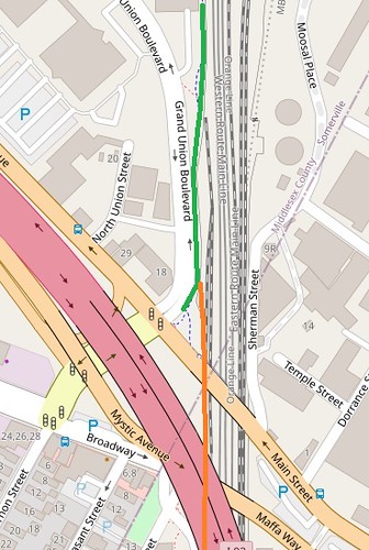
PAR storage options to allow for path
Explore this photo album by Somerville Alan on Flickr!
 flic.kr
CyclistAlan
New member
- Joined
- Mar 2, 2020
- Messages
- 10
- Reaction score
- 4
Any comments on my "conversation" with F-Line to Dudley?PAR would have to shove out towards 3rd Ave Crossing towards Swift (Fitchburg Route) or shove out towards Tower A on either ML 2,3, or 4 via the 645 crossover. Before I retired, there was talk of attempting to somehow construct a direct connection from Yard 10 (Innerbelt) to the mainline east out the Eastern Route mainline. This would be difficult give that OL flyover and all the supports for I-93.
F-Line to Dudley
Senior Member
- Joined
- Nov 2, 2010
- Messages
- 9,970
- Reaction score
- 12,303
Thank you very much for your insight about the power of PAR and DOT rail compared to shared-use path advocates. I don't disagree.
But ignoring that reality, would it be possible (understanding they won't to) for PAR to 1) make do with one track past Sullivan at the narrow section, 2) use one of the other 3 locations I identified, or 3) store and sort rail cars far to the north somewhere instead of any of the locations in Somerville/Charlestown.
Also - I'm unclear where you are referring to this idea as only a "dead-end" path? It would connect the existing path at Partners Health care with Inner Belt Rd. and then New Washington St. as shown in the images here.
THX.
PAR storage options to allow for path
Explore this photo album by Somerville Alan on Flickr!
1) No...PAR is not going to "make do" with one track. They literally can't use it with only one track because there's no way to change shoving directions with the locomotive without both. See earlier ops explainer. This is useless to them as one track. 2) No...I already outlined the reasons none of the other alts you ID'd would work in the slightest and would end up fouling Commuter Rails ops even worse. 3) No...as fully described, given the high value of the real estate PAR did receive in land-swap where they traded out Yard 8--namely, Lechmere Sq. high-rise rights at to-be-vacated old Green Line Station--absolutely no one has anything of value left in Somerville to offer them that they would take in exchange for Yard 21 rights.
Now...I did describe how MassDOT could--eventually--get them to vacate Yard 21 for the Urban Ring for staging areas outside of the City. Because MassDOT has property and freight grants statewide to offer them, and PAR runs across the whole northern half of Massachusetts with its most profitable yard facilities all outside 495. MassDOT can offer them a large "Pimp My Yard" grant in Deerfield, Ayer, Billerica, or Lawrence to make them bite. But no one besides MassDOT is going to make that happen for them, and MassDOT is not going to intervene now when DCR is already actively spending a large sum repairing that seawall for Assembly-Sullivan path that enables extremely similar linkage when it gets spurred behind Bunker Hill CC from Sullivan to link up to North Bank Bridge. Certainly no one is going to feel compelled to jump if Partners snaps their fingers, because Partners should've inserted themselves into the Assembly-Sullivan path hub first to get in on that action.
And...YES...it is a dead-end path. Access behind the freight wye to Innerbelt Rd. is cut off by the BET storage piles of rail and ties, associated storage sheds, and driveway where forklifts and heavy loaders are moving materials all day. It is physically fenced off the whole perimeter from Innerbelt to Roland St...no public passage possible. You must trailhead from down in the pit up to Cambridge St. or Roland St. at no connectivity gains over the Assembly-Sullivan DCR path. That fenced-in property is mission-critical Keolis staging area for all Commuter Rail track gangs, and there is zero room to move it. Commuter Rail is already in a MOW storage bind because the small materials piles lining the south border fence with Cambridge Crossing/Northpoint are being moved TBD to add more storage tracks...which means this area by the wye is the literal last 'dirty work' staging area left on the property. Under absolutely no circumstance are they giving that up when Keolis or the next contracted Commuter Rail operator would have legit beef in the next contract negotiation over meeting work deadlines after giving away all the track gangs' staging space to charity. They're not going to entertain something so self-damaging.
As per last post, all of these ownership and rights blockers are things the path lobby could have ID'd in one single phone call to the MBTA. It appears Partners or whoever is running that show did not do even that little advance homework before proceeding to study. That's on them. Squinting at this strip of land for an umpteenth time or the trail backers asking "pretty please...for us" isn't going to make them more willing to fork it over. Nor is an internet messageboard going to be able to bail them out via some novel unseen loophole when this is all property law in the hands of officials who deal with those legalities. It's official business requiring official inquiries...too bad for them if they skipped that step.
Bottom line is Boston local freights and Commuter Rail maintenance literally can't function without that space, really really can't function being forced out into even crappier local space out of misguided sense of charity to a multibillion dollar corporation, and nothing moves that brick-wall unless the multibillion-dollar concern has LARGE real estate holdings to barter...either locally or out by Pan Am's most profitable 495-land yards (like MassDOT does when it's Urban Ring time). Otherwise functional impossibilities are functional impossibles are functional impossibles.
That "Yard 14" layover yard was originally designed for 9 tracks. I remember seeing the original design on the wall at Cobblehill. For whatever reason, it did not happen. It's kind of sad how commuter rail has been so hemmed in by GLX. It was a miracle they didn't lose more tracks behind BET as was put forth in the early GLX designs. They didn't have a clue why we needed more than one track between Swift (Fitchburg Route) and
FX (3rd Ave). As for MW storage, I hear rumors that a lot of it is going to Iron Horse Park in North Billerica.
FX (3rd Ave). As for MW storage, I hear rumors that a lot of it is going to Iron Horse Park in North Billerica.
WormtownNative
Active Member
- Joined
- Dec 7, 2014
- Messages
- 510
- Reaction score
- 274
That "Yard 14" layover yard was originally designed for 9 tracks. I remember seeing the original design on the wall at Cobblehill. For whatever reason, it did not happen. It's kind of sad how commuter rail has been so hemmed in by GLX. It was a miracle they didn't lose more tracks behind BET as was put forth in the early GLX designs. They didn't have a clue why we needed more than one track between Swift (Fitchburg Route) and
FX (3rd Ave). As for MW storage, I hear rumors that a lot of it is going to Iron Horse Park in North Billerica.
Also thought I heard somewhere that if BET gets ridiculously crowded or needs to be moved, Iron Horse is also a possibility for expansion. Then again, I think I might have read that on RR.net, so it could've been just a foamer theory.
F-Line to Dudley
Senior Member
- Joined
- Nov 2, 2010
- Messages
- 9,970
- Reaction score
- 12,303
Also thought I heard somewhere that if BET gets ridiculously crowded or needs to be moved, Iron Horse is also a possibility for expansion. Then again, I think I might have read that on RR.net, so it could've been just a foamer theory.
It's not viable for day storage...too far out of town and only has access to the Lowell Line. All of that absolutely needs to stay in Somerville to keep the shifts moving, though if southside can secure Widett Circle, BTD Tow Lot, or any of those pieces it will be an enormous relief for BET to be able to get out from under having to support southside day storage. Because then not only does south have its storage needs fulfilled, but Readville Yard 2 (which itself is expandable out to the banks of the Neponset by evicting the recycling center on the easement next door) gains enough flex 8 miles out to be able to play host to new full-service southside EMU and coach heavy-repair shops. Which will be enough to trim BET's shop responsibilities for the south down to just the unified diesel locomotive shop. And possibly some native MOW south storage of its own on the expansion Readville land. That north v. south relief sequence is in turn extremely critical for being able to take the Grand Junction off the RR network for the Urban Ring at all...because the Worcester-Ayer backup route for equipment swaps is only viable if you can reduce the rate of swapping from 1-2 per day over today's GJ to maybe 2 per week through Worcester County. You can hit that cost-neutralizing target of trading much-reduced moves for longer distance if the only things you're swapping each week are Downeaster sets on AMTK rotation and strings of southside diesels going for shop work or 92-day FRA inspections...and don't have any coaches making the trip and no longer have to make so many trips solely for the sake of rebalancing equipment assignments.
Billerica, now that it's no longer a Superfund site, can also absorb a lot of MOW functions that isn't sited much of anywhere right now. The T has already funded a central ops satellite office at Iron Horse Park, though so far that's only booting a few desk jockeys non-critical to downtown OCS. But there at least will be some sort of 24/7 staff presence to build around with other functions, and somebody keeping the lights on for shift work around the office to pay for the security guards who can watch the yard. Options abound for consolidating most non- time-sensitive MOW functions out there: bigger consolidated rail/tie piles, relocation of the ballast pile from the Saugus Branch stub in Everett, a better recycle-dump facility for used ties than the siding in Charlestown (which the new Assembly-Sullivan path is going to pass right behind), storage of freight cars used for dirty work, offseason storage of the snowplow and leaf-spray cars, etc. They have never had anywhere to keep large material stock onhand and have always had to play fast-and-loose borrowing work cars because there's no places on the system to keep gons, flatcars, etc. stored in any quantity between active jobs. Alewife MOW, which is the machine shop for all the specialized steampunk-looking track machines and fleet of hi-rail pickup trucks, doesn't have anywhere near the storage space for that.
Now, just because Billerica is opening up as some sort of option doesn't mean you can zero out all MOW space at BET entirely. So let's head off right now the inevitable "so can the fence come down so Partners can have its incompetently studied Innerbelt path, pretty please with sugar on top?!?" NO. With all the piles on the south Northpoint strip of BET going away for storage expansion the north strip abutting the Yard 21 leads become all the more critical for supplying spot-repair material. You could never ever have a terminal district with all replacement track panel material 20 miles out town; spot repairs happen all the time on the extremely heavily-used track & switches in the North Station throat. So that 'dirty work' area is sacrosant, and is not going to fuck itself right off to Billerica if Partners only asks nicely enough. That too could have been settled with the same 1 single phone call to a T spokesflak before study resources were ever wasted.
Last edited:
- Joined
- Dec 10, 2011
- Messages
- 5,599
- Reaction score
- 2,719
I think the right path option will be at Street Level on the west side of the OL Station, along Clinton Place and Perkins & Brighton side of the station. It is an MBTA parcel (I think) at street level, not just at trench level). And is that a squatter having paved off-street parking on Perkins st?
 www.cityofboston.gov
Parcel 0201930003 - City of Boston
F-Line to Dudley
Senior Member
- Joined
- Nov 2, 2010
- Messages
- 9,970
- Reaction score
- 12,303
I think the right path option will be at Street Level on the west side of the OL Station, along Clinton Place and Perkins & Brighton side of the station. It is an MBTA parcel (I think) at street level, not just at trench level). And is that a squatter having paved off-street parking on Perkins st?
Parcel 0201930003 - City of Boston
I have no idea where that is, but the back alley off Clinton Pl. isn't nearly wide enough to mix residential vehicular access with path and still hits the same dead-end at Roland St. as the pit. There's no above-and-beyond there over the already-striped Cambridge St. bike lane.
I'm not seeing the unique catchment for anything over there given these constraints. Sullivan's going to become the nerve center of the world for diverging paths. You put one snaking behind Bunker Hill CC along the fence by the 93 decks and use the largely derelict freight siding that runs from a Hood Park Dr. bumper post to underneath the 93N Cambridge St. offramp to ramp it up to the crosswalk @ Sullivan Station (see trackmobile parked at Hood Park end on Google...it's connected but not used for any known function). The Bunker Hill path connects to Community College Station and the City Square-side entrance to the North Bank Bridge. There...there's your grade-separated hookup to the Charles network juvenation machine. Span Sullivan Station to the existing Assembly path at corner of Mystic @ Grand Union Blvd. by redoing the over-wide Mystic Ave. overpass and its disused ex-Sullivan Overpass merge by packing a grade-separated cycle track on one side. Make it compatible with the redev going on the north parking lots of the Square. There...there's your grade-separated interior hookup to Sullivan complementing the seawall/Alford path. Connectivity between legs further enhanced by City of Boston's Sullivan-makeover master plan and final decisions on things like what happens to the rotary underpass.
Innerbelt already has easy access to the Somerville Community Path with GLX. That is not underserved, and will be connected east of Lechmere to the North Bank area. So everything will be connected at one general junctioning point where the Charles network gives way to the Somerville & Sullivan/Mystic networks. Now for spanning Sullivan-Assembly with the Innerbelt, why micro-focus on such impossible odds as Yard 21 when McGrath teardown + dieting is going to serve up a direct Assembly-to-Community Path cycle track spine along the leafy "Fellsway South" with some hopeful spanning of the 93 spaghetti ramps. Doesn't the combo of that showcase project + 1 stinking traffic light's worth of Cambridge St. bike lane from the Sullivan Station trailheads give the Innerbelt quite plenty all-around connectivity?
I feel bad that Partners and whoever is representing them at the community level effed up so bad with their basic-most research that they're grasping at straws over Yard 21 for not making one single phone call to the T...and that they have to keep grinding at it in futility because resources have been committed. But, really, how clueless can you be when ^all that^ is happening around you and they don't make the slightest prerequisite effort to educate themselves or get embedded in multiple other connectivity advocacies netting real on-the-ground usability gains by the year that direct-serve their needs. I mean...Networking 101: this is why you make the basic effort to get to know your neighbors.
FormFollowsBudget
Senior Member
- Joined
- Jan 15, 2015
- Messages
- 2,318
- Reaction score
- 4,106
Blue Line shutdown details:
14 days long, aiming for 10, starting May 18.
74 shuttle buses, approximately 1 bus every 60 seconds, holding 15-20 passengers.
14 days long, aiming for 10, starting May 18.
74 shuttle buses, approximately 1 bus every 60 seconds, holding 15-20 passengers.
- Joined
- Dec 10, 2011
- Messages
- 5,599
- Reaction score
- 2,719
Inner Lowell Line (from Anderson to North Station) will be shutting down (bustitution) for a solid week with the stated goal of speeding Green Line work.
iirc, the goal is to increase the speed limitThat Alewife crossover... is that moving it closer to the station?