Massachusetts Statewide Bus Network

Koopzilla24

Active Member
Joined
Dec 20, 2022
Messages
244
Reaction score
632
Massachusetts is a state about the same size as New Jersey, but while NJ has a unified statewide public transportation network, MA is a patchwork of underfunded RTAs. Between these RTAs there are few connections, and service in most is abysmal. If there was a more unified statewide system to fill in the gaps between the RTAs it could drive up ridership and bring increased mobility to everyone in the state.

The state route network already connects town and city centers in a web of intertwining roadways. Using this as a framework, buses can be run in segments along these routes stopping at town centers, key points of interest, or transit hubs, and be numbered according the the route they run along. Obviously not every route would be served in its entirety as many segments are already covered by RTA services. Segmenting these routes properly could allow for decent headways being run with minimal buses.

In a state this small where driving all the way across it is a day trip, there really should be better public connectivity between small to medium population centers.
 
I think this might be a really good idea. Seeing how well it works in a nearby state is intriguing, but how can we quantify if it is a better way? That would be the first step in convincing people to take this seriously
 
This would be useful, especially to look at a statewide local bus map, a unified fare system so there would be seamless and free transfers. More standardized buses (i.e. all same wrapping/branding/color across the state), standardized bus stop signage across the state, whatnot.
 
There should be a statewide Transit Authority. I’ll leave the bikeshedding the details of the particular organization under the authority to denizens of this board.
 
I think this might be a really good idea. Seeing how well it works in a nearby state is intriguing, but how can we quantify if it is a better way? That would be the first step in convincing people to take this seriously

A study on the trips made between areas served by different RTAs would give an idea on who would use the service. i.e. someone who goes from Leominster to Worcester regularly would be going from MART to WRTA territory. Both of which are connected by MA-12, so a bus along that route would allow someone to go between the Montachusett and Worcester areas without the need to drive if there’s something preventing them from doing so, or they don’t want to. But I personally think the general mobility of a system like this would speak for itself. Teenagers could travel between towns safely and easily to hangout with friends/get part-time jobs without having to rely on someone with a car or license to bring them there. Or without the cost burden of their own car. On top of that, elderly folks or people with disabilities that cannot drive will be able to move about the wider state on their own.

A comparison I’d make to this theoretical service is the Route 34E bus of the MBTA. It runs from Forest Hills in Jamaica Plain to Walpole Center entirely along Washington St passing through the centers of Norwood and Dedham running about every 30min. I used to take this bus everyday during rush hour and it always filled to the point of having multiple standees. This was in the reverse commute direction of Boston with most people just going between town centers up to Dedham. All kinds of people were using it from parents with baby strollers to evening commuters to teens going to the Dedham Mall. The best case I can make for the idea of buses connecting smaller towns is through my own experience using a service that does.
 
I’m in progress on creating a map of how this system would look in the MetroWest area. Breaking up the routes into 15-20mi segments conveniently lines up well with hub towns/cities and end termini of routes. These segments also are all in the 30-35min range for drive time so with bus stops I’d expect them to be 45-60min end-end trip times.

An example of this would be a Framingham hub with Routes 126 and 135 passing through the city center and Routes 9 and 30 passing through a couple miles north. Framingham is already where the MWRTA is based out of and can be upgraded to service actual buses instead of vans. That’d serve as dispatch for the segments that’d serve a similar area to the existing MWRTA.
The 135W would serve from Framingham Station to the route terminus in Northborough while the 135E would go from the station to the Dedham Mall. The state route 135 ends at I-95 but it would make sense to extend it into Dedham with connections to MBTA buses.
The 126S would run to Woonsocket if permitted but otherwise stop short at Allouette Plaza in Bellingham. 126N would go to its route terminus at Rt 2. in Concord, possibly extended down Thoreau st. to the commuter rail station.
30W can go Natick mall to North Grafton, and 30E to Newton City Hall.
Route 9 is basically just a highway in eastern Mass so I don’t see a reasonable way to serve it with bus stops without dedicated BRT lane separation and stations.
 
Virginia would be a great state to study, partly for their Red-Blue-Purple consensus on state-subsidized, privately-operated bus.
Their state-level VA DRPT (Department of Rail & Public Transport) has wet-leased from Megabus (but state livery) to operate a mix of routes, which are basically a mix that connect "University Towns" and poverty pockets to the DC area. There'd be clear parallels in MA for connecting from the Berks, across college towns, and via isolated communities beyond the reach of rails to the Boston Area. Note that VA is not shy about poking into DC (Union Station), but they've purposely scheduled their buses to avoid the DC rush and boost reliability. These are inter-city buses, not commuter service.

For MA, I'd wonder if any routes could do a midday run to someplace like Stamford or New Haven or Albany to make routes "economic access" and truly double-ended.

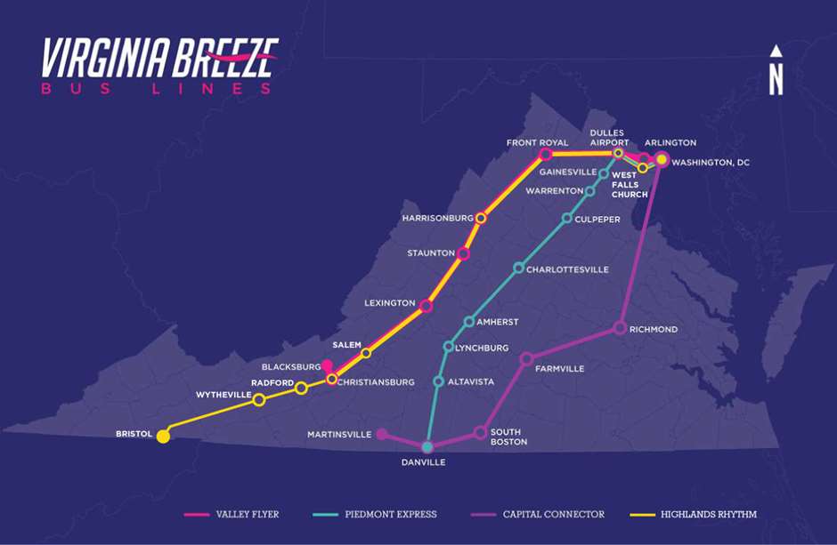
The Virginia system, so far, is:
1) "The State University Connector" (named: Valley Flyer, shown in Magenta) which connects Virginia Tech (Blacksburg), Virginia Military Inst / Washington & Lee (Lexington), James Madison U (Harrisonburg) to Dulles Airport, the Metro, & DC. Immediately over-patronized upon its launch, it spawned a second daily on weekends that became....
2) "Papermills & State Univs" (Highlands Rythm, shown in yellow) as an overlay/extension of the (1) route; a Environmental Justice route
3) Amtrak Overlay (Piedmont Express, shown in light blue), kind of the equivalent of, in Mass, overlaying BOS-FRA-WOR-SPG-PIT. It hits the DC-exurbs and UVa (Charlottesville) and Liberty U (Lynchburg), and runs to Danville (another Environmental Justice community)
4) Environmental Justice: The Capitol Connetor (in Purple) serves some of the poorest, most isolated communities of color (the triangle from Martinsville, Altavista, & South Boston, centered on Danville) and connects them to Richmond (which the other routes hadn't served)

virginia-breeze-routes_vb4-addition3.22.jpg


You might appreciate their study where they looked for communities that had been historically underserved and/or stranded when Greyhound cancelled service. https://www.ctb.virginia.gov/resources/2019/july/pres/1.pdf You'll see now that the remaining underserved areas are the rural communities either too far north or south of I-64 (Richmond-Norfolk) specifically across the southern tier of the state (South Boston to Norfolk) and the rural area along the Potomac (opposite Southern Maryland)....tobacco country.
 
Last edited:
I'd just be happy for Logan Express to have a stop at Union Station so I can stop driving to Framingham everytime I want to fly out of Boston
 
I'd just be happy for Logan Express to have a stop at Union Station so I can stop driving to Framingham everytime I want to fly out of Boston

They brought back the Back Bay service btw.
 
Virginia would be a great state to study, partly for their Red-Blue-Purple consensus on state-subsidized, privately-operated bus.
Their state-level VA DRPT (Department of Rail & Public Transport) has wet-leased from Megabus (but state livery) to operate a mix of routes, which are basically a mix that connect "University Towns" and poverty pockets to the DC area. There'd be clear parallels in MA for connecting from the Berks, across college towns, and via isolated communities beyond the reach of rails to the Boston Area. Note that VA is not shy about poking into DC (Union Station), but they've purposely scheduled their buses to avoid the DC rush and boost reliability. These are inter-city buses, not commuter service.

For MA, I'd wonder if any routes could do a midday run to someplace like Stamford or New Haven or Albany to make routes "economic access" and truly double-ended.

The Virginia system, so far, is:
1) "The State University Connector" (named: Valley Flyer, shown in Magenta) which connects Virginia Tech (Blacksburg), Virginia Military Inst / Washington & Lee (Lexington), James Madison U (Harrisonburg) to Dulles Airport, the Metro, & DC. Immediately over-patronized upon its launch, it spawned a second daily on weekends that became....
2) "Papermills & State Univs" (Highlands Rythm, shown in yellow) as an overlay/extension of the (1) route; a Environmental Justice route
3) Amtrak Overlay (Piedmont Express, shown in light blue), kind of the equivalent of, in Mass, overlaying BOS-FRA-WOR-SPG-PIT. It hits the DC-exurbs and UVa (Charlottesville) and Liberty U (Lynchburg), and runs to Danville (another Environmental Justice community)
4) Environmental Justice: The Capitol Connetor (in Purple) serves some of the poorest, most isolated communities of color (the triangle from Martinsville, Altavista, & South Boston, centered on Danville) and connects them to Richmond (which the other routes hadn't served)

virginia-breeze-routes_vb4-addition3.22.jpg


You might appreciate their study where they looked for communities that had been historically underserved and/or stranded when Greyhound cancelled service. https://www.ctb.virginia.gov/resources/2019/july/pres/1.pdf You'll see now that the remaining underserved areas are the rural communities either too far north or south of I-64 (Richmond-Norfolk) specifically across the southern tier of the state (South Boston to Norfolk) and the rural area along the Potomac (opposite Southern Maryland)....tobacco country.

Going off of New England's existing intercity bus network, I think implementing VA's public-private partnership to extend local services to smaller unserved towns would be great. Based on the NE transportation map from mass.gov, bringing services like PeterPan offers in western Mass to the rural deadzone of north-central Worcester County between Amherst and Littleton would be a huge boost to mobility in these communities.

What I envision for a state route-based bus system is meant to be more local transportation oriented. These would be designed to serve people just wanting to go a couple or a few towns over with the ability to connect to other buses and further away towns. This map shows a bit of what I'm thinking. These 8 segments of 4 different state routes could be run out of the MWRTA facility (with facility upgrades) and allow significant short to medium-distance mobility with maybe a single transfer. Multiple new public transportation connections with Commuter Rail stations are made as well allowing people to either drive a much shorter distance to access a station or cut out the drive entirely. Breaking into these segments also allows for shorter headways to be achieved. Conveniently, all of routes 135 and 126, and almost all of route 30 are to be covered by just two segments. Combine this with a new public-private partnership express intercity bus service to for example the Fitchburg-Leominster area and MA becomes a lot smaller. Even just a daily round trip between Fitchburg and Worcester would be huge for a lot of people.
 

Back
Top