Green Line Reconfiguration

The mid-block station actually gives a bit more wiggle room. You've got about 1700ft of slope on the shorter Boylston side, at a 5% grade that's 85ft of depth, plus the 20 from the existing tunnel depth gets you to a floor of 105' and a ceiling of about 80'. If that's deep enough to avoid any issues with building foundations, you might not even need the stacked station at Chinatown. That would free up the whole upper level for a mezzanine and pedestrian connection to Boylston. If we're feeling really brave, and width really isn't a problem, maybe we could even do Spanish solution platforms à la Park St to alleviate some capacity concerns.

Maybe that's not possible, but my point is that not being tied to the stupid loop at Boylston opens up some new possibilities, and I think they're worth exploring. As for costs, well that's going to be a problem no matter what until the MBTA learns how to effectively manage a project.
Again...they considered mid-block before and it was both a huge budget-buster with the labyrinthine mezzanines and a moderate grades-buster in addition to having very unfavorable transfer penalties. 2 stations with direct egresses legit priced out better than 1 with roundabout egresses it was so bad a strain. So there very likely is not a "Eureka!"-moment configuration for the core tunnel left un-studied under a rock given how many years of study went into formulating the core alignment in the first place and how many additional years of mitigation-related budget blowouts that core alignment managed to continue to accrue after it was picked. I certainly don't think you're going to be able to eliminate the bi-level tunneling to ease the grades situation. Tunneling under the base of the building foundations racks up additional mitigations in itself based on weight, soil properties, vibrations, and so on. You trade direct mitigation for indirect mitigation, which leaves too much potential for additional budget creep. You've still got a very complex and now likely deeper mezzanine level that has to fit perfectly so with the wider-straddling egresses reaching up into the level where the building foundations abut, which is going to bloat your budget another order of magnitude likely to the same "no mas!" conclusion the original mid-block study foray found. And you're pushing the grade limits even further going deeper; there are limits to how much deeper you can go, and you'll probably end up at a 'tweener level within the proximity envelope where indirect building mitigation (and its associated cost creep) is still required.

There's not a bounty of possibilities left here. It's very, very hard and the core alignment is very compromised even if it is still performance-workable for revenue service. Plus the harder you push it, the more unbuildably expensive it's going to get when the original project was already ruled unbuildably expensive once over. Again, unbuildably expensive not solely because they couldn't decide on the portal alignments. The core racked up enough continuously escalating damage to the budget that they simply didn't have any slack left to give for blowouts anywhere else. And given that you're trying to roam further west for junction with the Boylston St. Subway after a considerable distance of underpinning, you've still got a lot of potential for other blowouts even if you've eliminated the portal blowouts and the Boylston Loop blowouts. It might be a more manageable set of problem-solves than the portal and loop location, but this crayoning exercise is still being based upon a project that tripled its budget in 6 years of never-finished design work and was on a pace to keep open-endedly blowing it out to 4x, 5x, or more its original projected cost. That's a very unreliable set of base assumptions to work with, and you have to plan on there being more blowouts. Have a maximum pain threshold in mind for that budget, because you're probably going to go face-to-face with the ugly end of it trying to square these details. If you want this to graduate from Crazy Pitch to actionable proposal for an unfunded mandate, that pain threshold has to have a line in the sand inoculated against the considerable % of still-unfinished design work. That's just how unruly the Essex-Boylston corridor has proven in-practice: budget blowout potential on every corner and with every design tweak.
 
And you're pushing the grade limits even further going deeper; there are limits to how much deeper you can go
I gave the number. At a 5% grade around 80-105ft deep for the platforms is doable. It's not a big mystery. That should be below the surrounding foundations, although underpinning work would obviously still need to happen, and it would be expensive. But it's not like you're entirely constrained to the 40-45ft width of Essex St, there are options.
is still being based upon a project that tripled its budget in 6 years of never-finished design work and was on a pace to keep open-endedly blowing it out to 4x, 5x, or more its original projected cost.
But like with any recent project in Boston we have to ask, is this because it's hard or because nobody can get a grip on building costs? The core section of Crossrail, with it's crazy depth, massive stations, digging through very old parts and dense parts of one of the oldest major cities in the world, and of course delays and cost overruns, was still only around $1.5 billion per mile.

So, on the mid-block alternative, what did the 2005 report actually say?
  • It doesn't allow for a loop at Boylston (non-issue)
  • Grade exceedance with a Tremont St portal (not an issue with a Boylston St Subway connection)
  • Dwell times could exceed 49 seconds (not a huge deal)
  • Comparable in cost to two stations (not more expensive)
  • Added risk of cost overruns, though I'm personally doubtful that it's substantially more than the two stations alt.
  • Longer transfer times
None of that precludes a mid-block station with a Boylston St connector, unlike with SL Phase 3. It's less attractive compared to two stations, but not impossible. If it's that or nothing, it's an option.

However, this might not matter. I've gone back and perhaps I was a bit too cynical about the possibility of 1 level Boylston, 2 level Chinatown. If you can find the space, probably by pushing 1-level Boylston further west, the grades would be under 5.5%. (And no, that Boylston shift would not impact the grades, Charles St is the limiting factor on that side.)
 
SL Phase III's tunnel bore interacted with building foundations at both Chinatown and Boylston stations, adding a lot of mitigation cost to the core segment. The project's tripling price tag between 2003-2009 wasn't all tied up in the flailing over portal locations; a good portion of it was the escalating mitigations on the mostly-settled core alignment. In both station cases the building foundations narrowly breached the level of the upper/outbound bores. Not by much--it was a scrape--but it happened and building-by-building across the Essex-Boylston corridor we don't know what the depths are on other buildings that veer very close to the tunnel.


Chinatown:
View attachment 61417

Boylston:
View attachment 61418

It's hard because these close-abutting foundations are fairly deep, and there are clearly some buildings on the corridor that go >30 ft. deep. Increasing the tunneling depth is only going to increase the grades already so close to the max limit for LRT, so that's not an unlimited solution either. The Phase III project as designed maxed out just about all the possible wiggle room on the core alignment, leaving little left to chance.
Do you know/did it state in the report if the existing buildings are bearing on spread footings or if there are timber piles underneath the footings that are not shown? It also appears in this section that the station construction was to use slurry walls, similar to big dig technique. Was that how they planned to build the entire alignment? That section leaves little room for construction tolerance, especially if there are timber piles underneath an existing building. The CA/T at least had a much wider ROW to work with.
 
No, the tunnels were mainly intended to be either mined or TBM'd. TBM technology especially hasn't just remained static for 20 years, so this part would likely need to be re-evaluated.
They would have to look at using a large enough diameter to fit the stations within the bore. That should mitigate the concerns over the adjacent foundations and leave a larger margin for error. Of course, the head houses will need to be excavated but I think there’s room for that at Washington st across from the 2 Chinatown head houses. The boylston station connection would be more difficult.

Did they evaluate TBM launch pit locations for SL phase 3? I would think closing Columbus Ave at the intersection of Arlington/Stuart could be an option for the west end
 
They would have to look at using a large enough diameter to fit the stations within the bore.
If they ever come back to SL Phase III this will likely be in there, it was in the the most recent NSRL study.
Did they evaluate TBM launch pit locations for SL phase 3? I would think closing Columbus Ave at the intersection of Arlington/Stuart could be an option for the west end
I don't think so. If I had to pick a site today it would be Essex @ Kingston, that's a pretty rare open area of Downtown.
 
Essex @ Kingston, that's a pretty rare open area of Downtown.
Can the launch pit be in the middle of the alignment? I was under the impression that there had to be a pt at the starting and end points of the length of the tunnel.
 
Can the launch pit be in the middle of the alignment? I was under the impression that there had to be a pt at the starting and end points of the length of the tunnel.
That would probably be one end of the TBM bore regardless. Once you pass Surface Rd and South St you have to climb like hell to meet the Transitway.
 
using a large enough diameter to fit the stations within the bore
Not that I know much about this, but:

Wasn't this exactly how New York built their Second Ave Subway? IIRC, some critics say that was a major factor for cost blowouts.
 
Not that I know much about this, but:

Wasn't this exactly how New York built their Second Ave Subway? IIRC, some critics say that was a major factor for cost blowouts.
I'm pretty sure the 2nd Ave Subway is just boring (badum tss) old twin tubes with mined stations.
 
I believe the 2nd Ave phase 1 stations were cut & cover rather than mined, meaning maximum interface with under street utilities.

For our hypothetical tunnel, I'd actually probably say accept the disruption and launch our TBM by Boylston; if you're going to dig a pit, you might as well only do it once, and launch the TBM through what would become the station cavern, especially since you can usually back a TBM out (once disassembled.) Also, If my understanding is correct, the 1898-1920 Boylston Subway actually runs under the edge of the common, not the street itself, so you could dig a pit there. Disruptive, yes, but especially with recent movements towards shallow/surface launching TBMs, you're basically there once you clear the street utility layer - and something like a Rectangular TBM might be able to do it in a single pass.
 

Attachments

  • wmark-figure-01-boylston.jpg
    wmark-figure-01-boylston.jpg
    109.4 KB · Views: 30
I believe the 2nd Ave phase 1 stations were cut & cover rather than mined, meaning maximum interface with under street utilities.

For our hypothetical tunnel, I'd actually probably say accept the disruption and launch our TBM by Boylston; if you're going to dig a pit, you might as well only do it once, and launch the TBM through what would become the station cavern, especially since you can usually back a TBM out (once disassembled.) Also, If my understanding is correct, the 1898-1920 Boylston Subway actually runs under the edge of the common, not the street itself, so you could dig a pit there. Disruptive, yes, but especially with recent movements towards shallow/surface launching TBMs, you're basically there once you clear the street utility layer - and something like a Rectangular TBM might be able to do it in a single pass.

2nd Ave stations were mostly mined. Hence, the insane costs. 96th St was cut and cover as it was the transition point between the new (deep bore) and older (cut and cover) tunnels.
 
I believe the 2nd Ave phase 1 stations were cut & cover rather than mined, meaning maximum interface with under street utilities.

For our hypothetical tunnel, I'd actually probably say accept the disruption and launch our TBM by Boylston; if you're going to dig a pit, you might as well only do it once, and launch the TBM through what would become the station cavern, especially since you can usually back a TBM out (once disassembled.) Also, If my understanding is correct, the 1898-1920 Boylston Subway actually runs under the edge of the common, not the street itself, so you could dig a pit there. Disruptive, yes, but especially with recent movements towards shallow/surface launching TBMs, you're basically there once you clear the street utility layer - and something like a Rectangular TBM might be able to do it in a single pass.
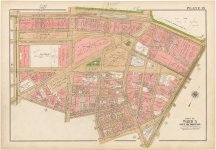
Do you know of any plates/plans of the subway between Arlington and Boylston stations? I’ve been looking for those to see how they provisioned in the post office square extension.
 
Do you know of any plates/plans of the subway between Arlington and Boylston stations? I’ve been looking for those to see how they provisioned in the post office square extension.
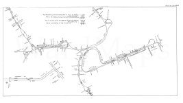
So here's the thing: as far as I can tell, they never actually published actual plans for getting from the Boylston Incline to the 1913 PO Square route, very possibly because this was the "simple" segment - in all likelihood, that segment of tunnel they were already planning on building - just to go to Park St. Keep in mind they were damnably ambitious back then, and they weren't afaid to change plans on the fly - the detailed plates that we see now were generally published as part of annual reports after the thing was built, not before. The initial 1911 plan for a Boylston subway was to build an additional 2 tracks to Park St, either underpining or adjacent to the then 15 year old Tremont Subway, starting from the public garden through a lower level for Boylston Station to a 3rd under level to Park St Station (The Park St Under platforms for what is now the Red Line already being under construction at that time.)
1000038202.jpg

That was well underway but they were asked by the legislature in 1913 to explore a new PO square terminus and/or connecting to the Tremont Subway, rather than building new tunnel all the way to Park Street which they agreed to and completed by 1914. As part of that, they moved towards a 4 track cross section, 2 in, 2 out, to manage expected congestion at Park St and so they moved the Public Garden incline into the median of Boylston by widening the street. Either way, the squeaky Boylston curve we know and love to this day was, obstensibly, temporary, until they could build a second terminus somewhere.
1000038184.jpg

1000038171.jpg

As far as I can tell, they built the new Boylston Incline, then pretty soon after forgot about the idea of running to Post Office Square, having apparently decided that in fact they were ok using Park Street as a single terminus and that they didn't actually need the additional capacity as they focused on other priorities like East Boston, Dorchester, etc. But the space for 2 additional tracks, PO square or Park St bound, was reserved under the street itself rather than the common back in 1913, which is visible in the 1917 system map as a notch out in the tunnel wall at Charles Street, where the ca1913 Boylston subway joins the 1897 Tremont.
1000038196.jpg
 

Attachments

  • 1000038172.jpg
    1000038172.jpg
    264.9 KB · Views: 43
  • Screenshot_20250328_185920_Chrome.jpg
    Screenshot_20250328_185920_Chrome.jpg
    714.8 KB · Views: 37
  • Screenshot_20250328_193046_Chrome.jpg
    Screenshot_20250328_193046_Chrome.jpg
    188 KB · Views: 40
  • wmark-plate-1250pct-80jpg_234b5f34-3e02-45fb-b431-fa8e10a33f2f.jpg
    wmark-plate-1250pct-80jpg_234b5f34-3e02-45fb-b431-fa8e10a33f2f.jpg
    189.7 KB · Views: 44
  • Sheet35-36-Ctl.Sub._EBAB (1).jpg
    Sheet35-36-Ctl.Sub._EBAB (1).jpg
    127.5 KB · Views: 48
Last edited:
Since @Riverside made this post about the "Criss-Cross" GLR model almost a month ago, as opposed to the more traditional "Tripod" model, I had been doing some internal evaluations of the two, in an attempt to figure out which one is better. In this process, as hinted at in this comment of mine, I realized that we need a cleaner framework to reason about capacity.

So I've designed such a theoretical framework, which abstract away the engineering details (tracks, flying junctions, etc) and several operational details (e.g. outlying branches).

For the first time in almost a year, I actually managed to write a post on my own blog about it:


Routing the Green Line Reconfiguration (Part 1): A Theoretical Framework of Capacity and Service Patterns


TL;DR:
  • The Green Line Reconfiguration (GLR) system likely has a theoretical maximum capacity of 80 TPH, up from today’s 32; but hitting this maximum is non-trivial.
  • Most prior GLR proposals, namely the “Tripod” and the (naive) “Criss-Cross” models, only hit 64 TPH instead.
  • Adding short turns terminating at Park to Criss-Cross gets you 80 TPH. It comes at the drawback of interlining — but as it turns out, interlining is inevitable for maximum capacity.
  • There are (at least) 5 different service patterns that hit 80 TPH, not just limited to short-turning Criss-Cross.
  • Evaluating them will be left for the future — but share your thoughts now!

GLR1_Alternatives.png


Feel free to discuss and evaluate these alternatives or the framework itself! I plan to do my own evaluations at some point, but those will definitely be influenced by everyone else's thoughts.

As another reminder, I have a list of potential future blog posts in the last section of the article. Let me know which ones you are most interested in or want me to write!
 
Since @Riverside made this post about the "Criss-Cross" GLR model almost a month ago, as opposed to the more traditional "Tripod" model, I had been doing some internal evaluations of the two, in an attempt to figure out which one is better. In this process, as hinted at in this comment of mine, I realized that we need a cleaner framework to reason about capacity.

So I've designed such a theoretical framework, which abstract away the engineering details (tracks, flying junctions, etc) and several operational details (e.g. outlying branches).

For the first time in almost a year, I actually managed to write a post on my own blog about it:


Routing the Green Line Reconfiguration (Part 1): A Theoretical Framework of Capacity and Service Patterns


TL;DR:
  • The Green Line Reconfiguration (GLR) system likely has a theoretical maximum capacity of 80 TPH, up from today’s 32; but hitting this maximum is non-trivial.
  • Most prior GLR proposals, namely the “Tripod” and the (naive) “Criss-Cross” models, only hit 64 TPH instead.
  • Adding short turns terminating at Park to Criss-Cross gets you 80 TPH. It comes at the drawback of interlining — but as it turns out, interlining is inevitable for maximum capacity.
  • There are (at least) 5 different service patterns that hit 80 TPH, not just limited to short-turning Criss-Cross.
  • Evaluating them will be left for the future — but share your thoughts now!

View attachment 61661


Feel free to discuss and evaluate these alternatives or the framework itself! I plan to do my own evaluations at some point, but those will definitely be influenced by everyone else's thoughts.

As another reminder, I have a list of potential future blog posts in the last section of the article. Let me know which ones you are most interested in or want me to write!
Alternative Criss Cross:

32 TPH between Kenmore and Seaport, 16 TPH from Nubian to Park St Inner, and 32 TPH from Huntington to Government Center.
 
Alternative Criss Cross:

32 TPH between Kenmore and Seaport, 16 TPH from Nubian to Park St Inner, and 32 TPH from Huntington to Government Center.
See, that's exactly what I thought when we discussed this.

However, at this point I'm not sure if it's worth it. One of the four items below need to be done:
  1. Flip the flyover junction tracks south of Boylston, so that outer tracks at Boylston connect to Boylston St, and inner tracks connect to Bay Village
  2. Flip the quad tracks between Boylston and Park with grade separation, so that Bay Village trains use Boylston outer and Park St inner
    • Requires rebuilding this section of the subway under Tremont St and part of Boston Common
    • Probably more feasible than #1, but still expensive and disruptive to existing operations
  3. Flip the loop north of Park St, so that Park St outer tracks loop around, while Park St inner tracks continue to GC (ala Kenmore loop)
    • Requires rebuilding the entire section of the loop north of Park St, to grade separate the new outer loop and the new inner thru-tracks
    • Seems infeasible -- space north of Park St is very tight, both laterally (Tremont St narrows) and vertically (constrained by street above and Red Line below)
  4. Build an entirely new ROW for Nubian to hook into Boylston Inner from the west
    • Along one of the several SL Phase III alignments that Riverside and you mentioned; the Charles St-Park Plaza alternative seems the most promising
I'll first make the executive decision to remove #1 and #3 from consideration: They achieve the same purpose as #2, but with worse engineering.

Now consider: What new infrastructure is needed?
Where Huntington trains feed into#2 (flip Boylston-Park)#4 (Nubian-Charles St)
Huntington-Arlington
(assuming Huntington trains use existing Arlington station, and possibly Copley station)
  • Boylston-Park flyover
  • A new Hynes-Seaport trunk that's grade-separated from existing Arlington station
    • EITHER: Pike Hugger, as Riverside proposed
    • OR: Quad-track Copley-Arlington, then use Kneeland/Essex/Marginal to SS
  • Charles St subway, from Boylston to BV
  • A new Hynes-Seaport trunk that's grade-separated from existing Arlington station
    • EITHER: Pike Hugger, as Riverside proposed
    • OR: Quad-track Copley-Arlington, then use Kneeland/Essex/Marginal to SS
Huntington-Bay Village (then Boylston Outer)
  • Boylston-Park flyover
  • Pike Hugger West (for Huntington)
  • A new Hynes-Seaport trunk that's grade-separated from Huntington's Pike Hugger West
    • EITHER: Diverted subway east of Arlington, using Kneeland/Essex/Marginal to SS
    • OR: Pike Hugger, with quad-tracked Pike Hugger West
      • This requires closing Arlington station altogether
  • Charles St subway, from Boylston to BV
  • Pike Hugger West (for Huntington)
  • A new Hynes-Seaport trunk that's grade-separated from BOTH Huntington's Pike Hugger West AND Boylston-Charles-BV subway
    • EITHER: Diverted subway east of Arlington, using Kneeland/Essex to SS
      • East of Arlington, you NEED to dive below Boylston-Charles immediately
    • OR: Pike Hugger, with quad-tracked Pike Hugger West
      • This requires closing Arlington station altogether

Note: "Pike Hugger West/East" = Pike/Marginal subway west/east of Bay Village, respectively. "Pike Hugger" means both the western and eastern segments are needed.

I won't attempt to evaluate them in great detail right now, but a few thoughts:
  • #2 (flip Boylston-Park), if practical enough, seems to strictly dominate #4 (Nubian-Charles)
    • Covers a much shorter distance, and has non-negative impacts on other infrastructure compared to $4
    • The wildcard is #2's own cost and practicality, especially with ongoing revenue service during construction
  • The top left quadrant (#2 & H-A) is essentially Riverside's original Criss-Cross proposal, + Boylston-Park flip
  • The bottom left quadrant (#2 & H-BV) is probably what you had been hinting at for a while
Regardless of the alternative, at least one new western segment & at least one new eastern segment have to be built in ALL scenarios:
  • West: Arlington + Pike Hugger West / Quad-tracked Arlington / Quad-tracked Pike Hugger West
  • East: Pike Hugger East / Kneeland / Essex
This applies to even the 5 original alternatives, before we even think about Nubian-Park Inner.

Also, if we fix #2 as given, we're essentially decomposing the problem into two: (a) How to enable Kenmore-Seaport; (b) How to do the Boylston-Park flip. This particular discussion thus only affects (b), so the real question is -- is eliminating the N-merge worth the Boylston-Park flip?

Given this decomposability, I don't think it's pertinent to us figuring anything out at this stage. It's really more of an operational question (impacts of the N-merge), and can be done as piecemeal.
 
Last edited:
  • Charles St subway, from Boylston to BV
  • Pike Hugger West (for Huntington)
  • A new Hynes-Seaport trunk that's grade-separated from BOTH Huntington's Pike Hugger West AND Boylston-Charles-BV subway
    • East of Arlington, you NEED to dive below Boylston-Charles immediate
I'm going to focus in on this section, how does this compare to the other alternatives?

Charles St Subway
This is basically entirely unavoidable if you want the full 80 TPH if you're feeding anything other than Kenmore trains into the inner tracks at Park St. Without it you need to somehow cram 48 TPH through 2 tracks at Boylston, which basically means dwells cannot be more than ~50 seconds. Uh, good luck with that, especially if it's the transfer station for Seaport service.

Pike Hugger West
Also entirely unavoidable. You either need it for Kenmore trains if you go with something along the lines of @Riverside's original proposal, or for Huntington trains for 'traditional' tripod.

A new Hynes-Seaport trunk that's grade-separated from BOTH Huntington's Pike Hugger West AND Boylston-Charles-BV subway
This should actually be possible without leaving Boylston St, barely. You've got around 550ft to descend 30 feet, which gives you a grade of around 5.5%. This avoids any problems from Arlington station. It's not really avoidable for the same reasons that the Charles St Subway itself is unavoidable.


So with that in mind, let's go back to alternatives 1-5:

Alternative 1: Needs the Charles St subway. Whether you want to use the Park St loop for Hyde Sq trains or Nubian trains is a separate question. Whatever trains use the Park St loop go via Charles St. I'm going to retroactively put my "Nubian to Park St Inner" proposal under this Alt since the infrastructure is basically the same.

Alternative 2: Requires a Huntington-Seaport connection while maintaining the Boylston St Subway as-is. There are plenty of options for how to do this, but none of them seem simpler or easier than a direct route via Essex St, which doesn't work with this service pattern. "Long Pike Hugger" with quad-track is likely necessary for this Alt.

Alternative 3: Could be done by extending the Pike Hugger Subway to Hynes, and using the existing curve at Copley for Huntington trains. However that would also mean cutting off the GLX and downtown generally from Huntington, which seems unwise.

Alternative 4: Either requires the continued use of the flat junction at Copley at 48 TPH (non-starter), or the full Pike Hugger Subway with an extra flying junction, and the longer Pike-Seaport connection. The latter isn't impossible, but it's substantially more interlined, and likely more costly than Alternative 1. For that to be justifiable, Huntington-Seaport service needs to be quite popular, as LMA service is still on the table with the current D branch as part of Alt. 1.

Alternative 5: I have no idea how you would even do a service pattern like this but extensive use of the flat junction at Copley seems necesssary.

I'd go ahead and strike out options 3 and 5. Cutting off Huntington from Downtown/North is not a good idea, and I don't see a way for Alternative 5 to be physically possible. That leaves 1, 2, and 4. All of these are probably possible, but alternative 1 seems to be by far the simplest. Yes Seaport gets fewer 1SRs. I think given the added complexity of the other alternatives, this is an acceptable comrpomise.


However, I think we're getting ahead of ourselves. There is an Alternative 6: None of the above. Huntington+Nubian both feed into Government Center, limiting their total to 32 TPH. Would that really be so bad? 7 TPH to both Riverside/Needham, 12 TPH to Nubian, and 6 TPH to Hyde Square or Arborway. You'd need to either start branching Nubian service further, or really crank service up to Riverside or Needham for that to become a serious limitation IMO. The latter seems unlikely, while the former is complicated. Geography supports the idea of branches along Washington St to Egleston and Dudley St to Uphams Corner, but the physical infrastructure really doesn't unless you're ready to accept a lot of single track.
 
Charles St Subway
This is basically entirely unavoidable if you want the full 80 TPH if you're feeding anything other than Kenmore trains into the inner tracks at Park St. Without it you need to somehow cram 48 TPH through 2 tracks at Boylston, which basically means dwells cannot be more than ~50 seconds. Uh, good luck with that, especially if it's the transfer station for Seaport service.
I'll focus on this, because I don't think that's true, and it affect everything else that follows in your comment. The main disagreement is feeding Huntington trains into Park St Inner (aka Boylston Inner).

Important clarification: Below, I use "Arlington" to refer to today's Arlington platforms. This is because some proposals may involve quad-tracking the Boylston St subway, thus adding more tracks and/or levels at Arlington station. Any such additions to Arlington station will be denoted "Arlington Under" for ease of notations.


If you absolutely want Kenmore-Seaport trains to use Arlington, then yes, Huntington trains need to use Charles St to get to Boylston Inner.

But what if we feed Arlington exclusively to Boylston Inner trains instead? This can include K-BI-PI, K-BI-PO, H-BI-PI and H-BI-PO trains.

Claim 1: If Kenmore-Seaport trains don't use Arlington, putting all Boylston Inner trains (from K and H) through Arlington is OK -- even if some Boylston Inner trains switch to Park Outer. (This is true even without the Boylston-Park flip.)
  • Boylston will take a maximum of 48 TPH totaled over its two tracks, as that's the total capacity of Park Inner and GC.
  • Boylston Outer will take a fixed 16 TPH from Nubian in any 80 TPH scenario.
  • Thus, Boylston Inner will take a maximum of 32 TPH. Since it's assumed that Arlington trains don't have another destination (i.e., not Seaport), all of them feed into Boylston Inner, so that's at most 32 TPH.
  • Note: As long as Boylston Inner sees 17 or more TPH, it results in a necessary N-merge between Boylston-Park, unless we build the Boylston-Park flip. However, this isn't an issue from a capacity-only perspective.
Claim 2: Consider any point X on today's eastbound Central Subway between Hynes and Boylston. If there's a way to have Kenmore-Seaport trains diverge west of X and Huntington-Boylston Inner trains join east of X, then everything is OK -- regardless of whether a Charles St subway of any length exists.
  • Basically, the entire Central Subway will never hit more than 32 TPH, because K-S already empties out before H-BI joins.
  • Note that this makes a few assumptions that are quite plausible:
    • The number of H-BI trains is no greater than K-S trains
    • K-BI trains use the full length of the existing Central Subway
    • Nubian trains don't use Boylston Inner
Claim 3: As long as Nubian doesn't feed into Boylston Inner, whether a Charles St subway exists isn't the deciding factor at all. Claim 2 holding for some X is the only necessary condition; whether X is exactly the Charles St intersection is irrelevant.

Observation 4: One feasible solution where X is west of Arlington is Riverside's original Criss-Cross proposal. Here:
  • X = Copley Square
  • Kenmore-Seaport trains diverge at Dartmouth St, to Pike Hugger West
  • Huntington-Boylston Inner trains join at Copley Square
  • If we retain the track connection along Central Subway while ensuring grade separation of everything, then you've enabled K-S, K-BI and H-BI.
My main insight from this: In some sense, this thought exercise provides an additional, unconventional justification for sending Kenmore-Seaport trains to Pike Hugger West (or Arlington Under), as opposed to Essex or Kneeland via Arlington. This time, it's not just "Pike Hugger is easier for C&C" etc -- but because it allows Huntington-Boylston Inner trains to leverage existing infrastructure more (thus avoiding a Charles St subway).

Pike Hugger West
Also entirely unavoidable. You either need it for Kenmore trains if you go with something along the lines of @Riverside's original proposal, or for Huntington trains for 'traditional' tripod.
On a high level, if we think of this as an abstract "second trunk between Copley/BBY and Boylston/BV", then definitely yes.

But kind of a nitpick: If a quad-tracked Copley-Arlington subway turns out possible, I think that may avoid the need for Pike Hugger West altogether. Not saying this is more desirable -- but I have indeed been placing a lot of thoughts on a quad-track Boylston subway lately.

A new Hynes-Seaport trunk that's grade-separated from BOTH Huntington's Pike Hugger West AND Boylston-Charles-BV subway
This should actually be possible without leaving Boylston St, barely. You've got around 550ft to descend 30 feet, which gives you a grade of around 5.5%. This avoids any problems from Arlington station. It's not really avoidable for the same reasons that the Charles St Subway itself is unavoidable.
True. I did figure that having to dig deep before Charles would still not be a deal-breaker overall, but good to have some concrete numbers!
 
As for the discussion of the 5 alternatives, with the caveat of replacing "need Charles St subway" with "need separation point X", here are some additional comments:
Alternative 3: Could be done by extending the Pike Hugger Subway to Hynes, and using the existing curve at Copley for Huntington trains. However that would also mean cutting off the GLX and downtown generally from Huntington, which seems unwise.

Alternative 4: Either requires the continued use of the flat junction at Copley at 48 TPH (non-starter), or the full Pike Hugger Subway with an extra flying junction, and the longer Pike-Seaport connection. The latter isn't impossible, but it's substantially more interlined, and likely more costly than Alternative 1. For that to be justifiable, Huntington-Seaport service needs to be quite popular, as LMA service is still on the table with the current D branch as part of Alt. 1.
My opinion on Huntington-Seaport is quite the contrary: I think the Full Pike Hugger is the best alternative for Huntington-Seaport alone.
  • The distance disadvantage -- the most significant drawback of Full Pike Hugger -- is by far the least notable for Huntington-Seaport than for any other service pattern. I measure 1.33 mi from Huntington/Exeter to Essex/Surface via the Pike. That becomes a "whooping" 1.29 mi via Exeter-Boylston-Essex, and 1.23 mi via Stuart-Kneeland-Surface. If you say Full Pike Hugger is longer, I'm not feeling it.
  • Even accounting for uncertainties near South Station, the Full Pike Hugger is still easier to build (likely by a notable margin), especially when distance isn't a huge concern. In contrast, no matter how you slice it, Essex is by far the hardest to build among the "eastern half" options: no other alignment runs into building mitigation risks even after accounting for forced TBM.
More broadly speaking, I think we should avoid "working backwards" to cross out theoretical alternatives because of being too married to particular alignments. Hope this doesn't come as an offense, but the overall impression I got from your comment was that you started by assuming Essex is the default option for the eastern half. Everything else builds upon this assumption, and other eastern alignments only come into play when absolutely necessary. Frankly, a key reason why I even wrote this post is to minimize the influence of engineering details from high-level decisions.

Alternative 5: I have no idea how you would even do a service pattern like this but extensive use of the flat junction at Copley seems necesssary.

I'd go ahead and strike out options 3 and 5. Cutting off Huntington from Downtown/North is not a good idea, and I don't see a way for Alternative 5 to be physically possible.
I believe there are very plausible builds for Alternatives 3/4/5 that allow Huntington to connect to Park/GC, nor do I think any of them requires flat junctions that absolutely cannot be replaced with flying junctions. Hopefully this will be made clearer once I get to elaborate in future posts.

However, I think we're getting ahead of ourselves. There is an Alternative 6: None of the above. Huntington+Nubian both feed into Government Center, limiting their total to 32 TPH. Would that really be so bad? 7 TPH to both Riverside/Needham, 12 TPH to Nubian, and 6 TPH to Hyde Square or Arborway. You'd need to either start branching Nubian service further, or really crank service up to Riverside or Needham for that to become a serious limitation IMO. The latter seems unlikely, while the former is complicated. Geography supports the idea of branches along Washington St to Egleston and Dudley St to Uphams Corner, but the physical infrastructure really doesn't unless you're ready to accept a lot of single track.
I have always had the belief that Huntington has enough demand for at least 24 TPH. After doing a lot of work with residential and employment densities in the past year, this belief has only strengthened.

Huntington Ave borders some of the absolute densest Census blocks in the entire metro area. IIRC, Symphony station has one of the most populous walksheds of all rapid transit stations, if not the #1 (which means that nearby stations are not far behind). On most days, LMA seems like a bigger destination than Kenmore is.

I believe most people would agree that the Central Subway deserves near-full capacity. I myself also think that the combination of Prudential, Northeastern, MFA, LMA and Brigham Circle is stronger than that of Hynes and Kenmore. (I purposely excluded Symphony if people think it's replaceable by Mass Ave OL, even though that can be debatable.) So if Kenmore can justify 32 TPH, why can't Huntington?
 

Back
Top