TheRatmeister
Senior Member
- Joined
- Sep 23, 2023
- Messages
- 1,584
- Reaction score
- 3,212
With more maintenance and/or looser safety standards.How did trains do it back in the day?
With more maintenance and/or looser safety standards.How did trains do it back in the day?
Jointed rail doesn't affect track class. You can run 90 MPH on jointed rail if it's maintained well enough, though it would obviously be a rougher ride than if you did the same on welded rail. Track classes have more to do with how many ties per X feet of track are allowed to be decayed, how tightly the rail must conform to gauge, how worn the rail is allowed to be, and so on. The joints don't really factor, because even Class 8/165 MPH tracks have *some* very occasional joints to them.I'm pretty sure that the tracks past Buzzards Bay are jointed rail, not welded rail. If you want to go faster than 30 mph, you'd need to replace the jointed rail with continuous welded rail. It's not likely to happen until the CapeFlyer gets replaced with a full Commuter Rail schedule.
Why did the New Haven RR pay for 79 MPH track if the ROW geometry limited speeds to 50 MPH in practice? What other “bang for your buck” do you get for making that extra level of expenditure in maintenance, besides higher speeds?Again...Class 3-4 is more an idealized maintenance standard for commuter rail-class service and the wear-and-tear reps that entails than a be-all/end-all speed limit thing.
Continuously Welded Rail reduces the impacts and shocks of the track joints (increasingly irregular with time) on the wheels and other undercarriage components, significantly reducing rolling stock maintenance. It also provides for a smoother ride, even at the lower speed.Why did the New Haven RR pay for 79 MPH track if the ROW geometry limited speeds to 50 MPH in practice? What other “bang for your buck” do you get for making that extra level of expenditure in maintenance, besides higher speeds?
As I said, track classes are a maintenance standard, not an aspirational speed limit. There was a lot of traffic on the Cape back in the first half of the 20th century...daily commuter rail, a fat schedule of seasonal extras, long-distance traffic from New York, lots of freight, and lots of military traffic. It was a profitable corridor for them. The number of daily movements was more befitting of Class 4 track than Class 3, so that's what they maintained the track at.Why did the New Haven RR pay for 79 MPH track if the ROW geometry limited speeds to 50 MPH in practice? What other “bang for your buck” do you get for making that extra level of expenditure in maintenance, besides higher speeds?
That would depress the ridership quite a bit from a reactivation of the old ROW. You'd miss Brewster center and all the density along 6A on the north shore, be over a mile from Harwich center, and be over a half-mile from Orleans center. The Mid-Cape Expressway was laid out to mostly chew up conservation land and avoid the village centers. With these towns being intrinsically very small and there not being a lot of sidewalk or bike lane coverage on the Cape, you really need to hit the village centers that grew into village centers because of the ROW to net much of a station catchment. The ROW is legally landbanked to South Dennis, and de facto landbanked to Wellfleet. If there's truly a market for Commuter/Regional Rail-level service way out here (I much doubt it), it rises to the standard of "greater good" for displacing the bike path or meriting a more expensive rail-with-trail. If you're considering the highway because the trail is the more "valuable" use of the ROW, the plot has already been lost because that conclusion means rail's ridership potential is much too low to hack it anywhere.It would be great if Cape Cod eventually gets Commuter Rail service past Hyannis. To avoid the brunt of the NIMBY backlash, the tracks could be laid alongside Route 6 out to the Orleans/Eastham Rotary, instead of alongside the Rail Trail.
As above, a better metric rather than municipal population (almost meaningless given how physically large and spread out some of these towns are) is station catchment. Which does include things like walkability scores and major thoroughfares access. It's a much tinier slice when factored that way, below the threshold of feasibility in all likelihood. The Cape just isn't very walkable or bikeable outside of the rail trail because of the limited on-road infrastructure, and the density in those physically very large towns is scattered because the road network only pools from certain directions. The village centers, while vibrant and robust, are small in scope. The NYNH&H's previous service was so long on-the-clock in part because they had to stop at every single village center and micro-village center in order to scoop up enough ridership to make ends meet on their P-town and Chatham runs, and that simply didn't work anymore after the 1920's when most households started owning cars. You've got 6 stops east of Yarmouth Jct., most of them off-center from the villages because of the highway layout and thus needing to be park-and-ride oriented. The New Haven needed 9 over the same on-ROW distance to square its catchment math (and then another 7 to P-town). If you went on-ROW to chase the density, you'd still need more stops at more travel time to make it work.There's probably more than enough demand for train service past Hyannis, as the Lower Cape's population swells during the summer:
Not all trains would go all the way into Boston; some would short turn at Hyannis, Buzzards Bay, or maybe even Wareham. I know there's probably some specific reason why this won't work, so I'm interested to hear any feedback.
- Yarmouth
- Offseason pop: 25,023 (2020 census)
- Summer pop: ~48,000 (source)
- Dennis
- Offseason pop: 14,674 (2020 census)
- Summer pop: ~52,000 (source)
- Harwich
- Offseason pop: 13,440 (2020 census)
- Summer pop: ~37,000 (source)
- Brewster
- Offseason pop: 10,318 (2020 census)
- Summer pop: ~30,000 (source)
- Chatham
- Offseason pop: 6,594 (2020 census)
- Summer pop: ~19,000 (source)
- Orleans
- Offseason pop: 6,307 (2020 census)
- Summer pop: ~19,000 (source)
- Eastham
- Offseason pop: 5,752 (2020 census)
- Summer pop: ~20,000 (source)
For the travelator between DTX and SS, I believe that the space already exists on top of the Red Line Tunnel -- it is used for storage or something like that? It may not go all the way now due to Big Dig impact.My wishlist, from most practical to a little more fanciful:
* Major park-and-ride facility at the I-90/I-95 junction on the Framingham/Worcester line. Why hasn't this happened yet? Let NIMBYs not be the blocker. Site it on the former Liberty Mutual office buildings located right alongside the ROW AND alongside the junction: https://maps.app.goo.gl/Gri3RgKKuxCwuF1A6.
* Cut and cover an underground travelator from DTX to South Station. This will greatly improve transit access from all areas served by the Orange Line and Green Line to all areas served by SL1-3, including the many jobs in the Seaport, by removing the need for a Red Line transfer (and the psychological uncertainty about commute time that comes with it).
* Convert the Grand Junction to Green Line, creating a Green Line loop through Boston and Cambridge. Creates a bevy of new transit opportunities for riders from across the city and connects BU, MIT, and future Harvard campuses.
* Bring the Watertown Branch back in parts as a Green Line extension, running on an elevated ROW if needed. Begin it around West Station, hooking it up to the existing Green Line and the new Grand Junction Green Line loop. Open up Watertown and Waltham to high-rise development.
* Build a rail connection between the Fitchburg and Worcester lines in the Newton/Weston area. There's only about one mile between them here. Major NIMBY land, I know, but I-95 is already here, and in the worst-case the line could simply be run alongside I-95 for most of its length. Create a rail loop from South Station to North Station, create cross-terminus routes e.g. from Worcester to North Station, and use it for equipment transfers that used to run over the Grand Junction.
* Run a BRT (or at least bus lanes) along the length of I-95 from at least Woburn to Westwood, if not from Peabody to Braintree. Intersect it with every commuter rail line and rapid transit line which crosses or reaches I-95. Provide station access to every major junction and major office park along I-95. Imagine the transformation this could bring, by making office parks on I-95 once again appealing to companies who in recent years have squished themselves downtown, in Kendall, and in the Seaport. My sense is that many of these companies did so to attract younger workers who want to live in the city, but at the cost of torturous commutes for older workers with families who live in the suburbs. By making offices on the 95 loop accessible to people who wish to live in the city, a nice averaging of location can be achieved, which would help relieve the pressure on the housing market inside of I-95.
My wishlist is rooted in the following beliefs:
- Compared to many other American cities, commuting in Boston is long and tortuous.
- Compared to many other American cities, residential real-estate in Boston is ridiculously expensive.
- The difficulty of commuting forces commuters into a limited set of options for where to live which are practical to get to their workplace. For example, people who work in Seaport and Kendall bias heavily toward housing which is along the Red Line axis, driving up cost in these areas and underutilizing residential areas alongside other lines, such as Orange and Blue.
- The migration of companies from the 495 and 95 belts into the downtown / Kendall / Seaport core has brought vitality to Boston, but resulted in terrible commutes for people who live in the suburbs and a lot of price pressure on housing inside of I-95.
- Obvious transit opportunities are being left untapped because the system hasn't caught up to the last 50 years of changes in population centers and highway networks.
- Seizing these obvious opportunities creates the potential to spread housing demand more evenly across the city and create capacity for building more housing without crushing the existing transportation network
No kidding! Yes, I wonder if it could be resurrected. Would be super unfortunate if they blocked the path for the Big Dig.For the travelator between DTX and SS, I believe that the space already exists on top of the Red Line Tunnel -- it is used for storage or something like that? It may not go all the way now due to Big Dig impact.
Travelator the Winter Street concourse DTX to Park as well.
No kidding! Yes, I wonder if it could be resurrected. Would be super unfortunate if they blocked the path for the Big Dig.
If there is a clearance issue with the Big Dig tunnels, I wonder if the concourse could simply be laid on either/both sides of the tracks. But there may be building foundations in the way.
At present, the concourse definitely ends about halfway between Otis and Devonshire. The emergency egress is roughly -- perhaps exactly -- at the end of the concourse, at 80 Summer St. As you come east, you eventually just face a massive wall with a stairway to the left (egress) and a very small crawlspace dead center at the floor. Immediately inside of the perhaps 3x3x3 crawl space it drops straight down to the Red Line tunnel (so basically it is just for ventilation).
We have a data point against this, and it's parking utilization at Riverside. It's crap, and has (AFAIK) never come close to filling up, even pre-COVID. It was at around 38% utilization at peak periods. Maybe with fast and more frequent than today regional rail service it would be more compelling, but right now that seems unlikely.* Major park-and-ride facility at the I-90/I-95 junction on the Framingham/Worcester line. Why hasn't this happened yet? Let NIMBYs not be the blocker. Site it on the former Liberty Mutual office buildings located right alongside the ROW AND alongside the junction: https://maps.app.goo.gl/Gri3RgKKuxCwuF1A6.
With the travelator running you're looking at 4.5 minutes to DTX, probably more like 7-8 to Park St. Based on that I'd have to say that any travelator needs to justify itself on OL-Seaport demand alone. And the travelators must be working or the transfer really just doesn't work and people will be quite upset. There are also issues with incorporating them into the existing station design. I don't really see how you can get people from the OL to the new concourse without either going out and back through the gateline, removing the direct connection to the shopping center, or digging a new, parallel tunnel. The former seems like the best option but without a tap in/tap out system it doesn't work. And obviously there's the cost of digging the tunnel itself, you could also just put that money towards something else.* Cut and cover an underground travelator from DTX to South Station. This will greatly improve transit access from all areas served by the Orange Line and Green Line to all areas served by SL1-3, including the many jobs in the Seaport, by removing the need for a Red Line transfer (and the psychological uncertainty about commute time that comes with it).
* Convert the Grand Junction to Green Line, creating a Green Line loop through Boston and Cambridge. Creates a bevy of new transit opportunities for riders from across the city and connects BU, MIT, and future Harvard campuses.
Same deal as before. With what central subway capacity? If you want to hook it into the Grand Junction, it should just be a new subway line at that point. Here's what that might look like.* Bring the Watertown Branch back in parts as a Green Line extension, running on an elevated ROW if needed. Begin it around West Station, hooking it up to the existing Green Line and the new Grand Junction Green Line loop. Open up Watertown and Waltham to high-rise development.
The 90/95 interchange really makes that difficult. You either need to tunnel under it, or go over it. It's also not really a huge boon for riders. It only opens up a couple new routes (Worcester to NS and Wachusett to South Station), both of which are pretty easily done with a subway connection today. The benefit for equipment moves is nice if you close the GJ (The alternative is Worcester-Ayer) but ideally those moves should mostly just not happen. Build the South Side Maintenance facility yesterday.* Build a rail connection between the Fitchburg and Worcester lines in the Newton/Weston area. There's only about one mile between them here. Major NIMBY land, I know, but I-95 is already here, and in the worst-case the line could simply be run alongside I-95 for most of its length. Create a rail loop from South Station to North Station, create cross-terminus routes e.g. from Worcester to North Station, and use it for equipment transfers that used to run over the Grand Junction.
This is dependent on making connections to the rail lines that cross 128, and indeed building more rail lines which cross 128, but if you can do that I do think it's a good idea. BRT (especially with double-articulated vehicles) is well-suited to run on the existing road infrastructure.* Run a BRT (or at least bus lanes) along the length of I-95 from at least Woburn to Westwood, if not from Peabody to Braintree. Intersect it with every commuter rail line and rapid transit line which crosses or reaches I-95. Provide station access to every major junction and major office park along I-95. Imagine the transformation this could bring, by making office parks on I-95 once again appealing to companies who in recent years have squished themselves downtown, in Kendall, and in the Seaport. My sense is that many of these companies did so to attract younger workers who want to live in the city, but at the cost of torturous commutes for older workers with families who live in the suburbs. By making offices on the 95 loop accessible to people who wish to live in the city, a nice averaging of location can be achieved, which would help relieve the pressure on the housing market inside of I-95.
This is why the Red-Blue connector is important.The difficulty of commuting forces commuters into a limited set of options for where to live which are practical to get to their workplace. For example, people who work in Seaport and Kendall bias heavily toward housing which is along the Red Line axis, driving up cost in these areas and underutilizing residential areas alongside other lines, such as Orange and Blue.
NIMBY's aren't the blocker. Driving time is the blocker. It's physically slower to get to a mainline Worcester Line parking lot than it is to get to the (aforementioned underutilized) Riverside lot. From Pike EB you have to drive 2 miles from the foot of the Park Rd. overpass on the offramp to get to the same spot on top of the overpass...through the loop ramps, up the 128N frontage road, to the MA 30 exit, 3 lights on 30 (through usually bad rush-hour traffic backed up at the lights) to left on Park Rd., then a good distance down Park to Riverside Rd. To reach existing Riverside station, you go over a half-mile shorter down 128S to the Grove St. offramp, no lights, no stopping, and way less traffic to the Riverside lot. The only direction the mainline stop would be faster is Pike WB coming out of Boston, and that's precisely where ridership is going to be weakest because the West Newton and Auburndale lots sop up most of the people doing that by car.* Major park-and-ride facility at the I-90/I-95 junction on the Framingham/Worcester line. Why hasn't this happened yet? Let NIMBYs not be the blocker. Site it on the former Liberty Mutual office buildings located right alongside the ROW AND alongside the junction: https://maps.app.goo.gl/Gri3RgKKuxCwuF1A6.
Very expensive for little utilization. You'd have to blow up a lot for flyovers/flyunders at the Worcester Line junction to get across the sprawl of the Pike interchange, lane-shift the whole of 128 one lane's worth to the west to fit in the ROW along Stony Brook Basin, and shiv in an extremely sharp and slow eastbound wye at the Fitchburg Line to run in a circuit. Nobody's going to use it for north-south circuit service when it takes 30 minutes to get to/from 128 on each mainline, the link itself is in a stark density cavity carved out by the reservoir and generates no ridership of its own, and you wouldn't be able to stop at 128 on either mainline because the junctions on the circuit would each occur before the nearest sited 128 stop. Worcester-North Station was also previously studied in 2012 via the Grand Junction, and didn't earn a recommended rating because the Lansdowne and Back Bay stops contributed more total ridership left behind than was offset by brand new Kendall and North Station ridership from MetroWest (nevermind everything else on the mainline inside of 128). It's also not needed for equipment transfers, because the in-design Readville Vehicle Maintenance Facility sops up most of the north-south swaps. Such that transfers that are now happening daily on the Grand Junction go down to a couple times per week and can be consolidated into mega T+Amtrak lash-ups. If you want to take the Grand Junction off the national rail network to convert to LRT, the upgraded Worcester-Ayer route can handle a couple of longer-distance equipment swaps per week at basically par crew hours to a what's now a week's slate of daily GJ swaps.* Build a rail connection between the Fitchburg and Worcester lines in the Newton/Weston area. There's only about one mile between them here. Major NIMBY land, I know, but I-95 is already here, and in the worst-case the line could simply be run alongside I-95 for most of its length. Create a rail loop from South Station to North Station, create cross-terminus routes e.g. from Worcester to North Station, and use it for equipment transfers that used to run over the Grand Junction.
Lots of proposals exist for better shuttle bus and jitney service from the mainline stops to the adjacent office parks. Particularly at the proposed Weston/Waltham Fitchburg Line superstation and the proposed Green Line Newton-Needham branch, where office shuttles were baked into the core proposals. But those are only pitched as quick sweeps from the nearest home stop. What you're proposing here is more like a full-on Outer Ring. And I'd caution that there's not nearly enough continuous density along 128 to sustain that because of the copious amounts of conservation land between office parks. It's desolate in the Bedford State Forest, Weston, Needham Flats-Dedham, and Blue Hills stretches. Very few people are going to ride a longer circuit as if they're making transfers between rail mainlines. Like...virtually no one is going to commute outbound to Riverside to change to radial BRT to change to Amtrak at Westwood. The trips are very near-range 'clumpy' to the nearest office parks to the home mainline stop, and don't really cross-pollinate around a ring. If cross-pollination is what you want, I think you get that a lot sooner by simply implementing Regional Rail frequencies well enough to start enabling real Purple-to-Purple transfers in the CBD...then crest that trend with an eventual North-South Rail Link build...then you do trying to force-fit an Outer Ring into a thing. The amount of land around 128 tied up forever as conservation land is simply going to inhibit those office-park 'clumps' from ever reaching across into contiguous density befitting a well-defined circumferential line.* Run a BRT (or at least bus lanes) along the length of I-95 from at least Woburn to Westwood, if not from Peabody to Braintree. Intersect it with every commuter rail line and rapid transit line which crosses or reaches I-95. Provide station access to every major junction and major office park along I-95. Imagine the transformation this could bring, by making office parks on I-95 once again appealing to companies who in recent years have squished themselves downtown, in Kendall, and in the Seaport. My sense is that many of these companies did so to attract younger workers who want to live in the city, but at the cost of torturous commutes for older workers with families who live in the suburbs. By making offices on the 95 loop accessible to people who wish to live in the city, a nice averaging of location can be achieved, which would help relieve the pressure on the housing market inside of I-95.
Lots of great thoughts. Riverside isn't really a valid comparison, is it? Green Line ride all the way to the major employment centers is slow and unreliable in comparison to commuter rail. Commuter rail offers fast and direct access to Back Bay and South Station, with connecting service to Orange, Red, and Silver.We have a data point against this, and it's parking utilization at Riverside. It's crap, and has (AFAIK) never come close to filling up, even pre-COVID. It was at around 38% utilization at peak periods. Maybe with fast and more frequent than today regional rail service it would be more compelling, but right now that seems unlikely.
With the travelator running you're looking at 4.5 minutes to DTX, probably more like 7-8 to Park St. Based on that I'd have to say that any travelator needs to justify itself on OL-Seaport demand alone. And the travelators must be working or the transfer really just doesn't work and people will be quite upset. There are also issues with incorporating them into the existing station design. I don't really see how you can get people from the OL to the new concourse without either going out and back through the gateline, removing the direct connection to the shopping center, or digging a new, parallel tunnel. The former seems like the best option but without a tap in/tap out system it doesn't work. And obviously there's the cost of digging the tunnel itself, you could also just put that money towards something else.
")
Love it! This is exactly what I have been thinking. Don't link it to the central trunk, at least not directly. Let people transfer at a crossover station if needed. Running it as a separate line is fine, but I'd suggest using GL compatible equipment, so that if commuting patterns ever changed in such a way that a new service routing would make sense, then it would be feasible. I think one of the best things that can be done is to build flexibility in the network to create new routings, just like busses can be adjusted (a big plus point for BRTs)Same deal as before. With what central subway capacity? If you want to hook it into the Grand Junction, it should just be a new subway line at that point. Here's what that might look like.
This is fair. I can get on board with this being more fanciful than useful. It just seems like such a missed opportunity for *connectivity*. I could imagine a frequent-service loop line running NS to SS, hitting the most densely populated sections west of Boston.The 90/95 interchange really makes that difficult. You either need to tunnel under it, or go over it. It's also not really a huge boon for riders. It only opens up a couple new routes (Worcester to NS and Wachusett to South Station), both of which are pretty easily done with a subway connection today. The benefit for equipment moves is nice if you close the GJ (The alternative is Worcester-Ayer) but ideally those moves should mostly just not happen. Build the South Side Maintenance facility yesterday.
If we are committing to that fairly large expense, I'm not convinced it would be best to build it as a regional rail line. You really want something more nimble, that can handle sharper curves as the line moves on and off the highway ROW to hit nearby business parks, and steep grades to navigate road junctions.
Agreed. I think of Seattle for an example of this, where a lot of money, effort and land has been spent on BRT, highway bus lanes, and light rail throughout the metropolitan area, and the results work really well. Many Microsoft employees work in suburban Redmond and live in the vibrancy of central Seattle, and utilize the highway BRTs to make this happen. I imagine similar could be done to unlock the I-95 office parks for Bostonians.This is dependent on making connections to the rail lines that cross 128, and indeed building more rail lines which cross 128, but if you can do that I do think it's a good idea. BRT (especially with double-articulated vehicles) is well-suited to run on the existing road infrastructure.
Thanks for the great thoughts. My thoughts about Riverside are similar to what I wrote above to @TheRatmeister.NIMBY's aren't the blocker. Driving time is the blocker. It's physically slower to get to a mainline Worcester Line parking lot than it is to get to the (aforementioned underutilized) Riverside lot. From Pike EB you have to drive 2 miles from the foot of the Park Rd. overpass on the offramp to get to the same spot on top of the overpass...through the loop ramps, up the 128N frontage road, to the MA 30 exit, 3 lights on 30 (through usually bad rush-hour traffic backed up at the lights) to left on Park Rd., then a good distance down Park to Riverside Rd. To reach existing Riverside station, you go over a half-mile shorter down 128S to the Grove St. offramp, no lights, no stopping, and way less traffic to the Riverside lot. The only direction the mainline stop would be faster is Pike WB coming out of Boston, and that's precisely where ridership is going to be weakest because the West Newton and Auburndale lots sop up most of the people doing that by car.
If there isn't some other incentive to go to the stop like rich reverse-commuting TOD that Town of Weston is loathe to zone for, you really don't have the makings of a well-utilized station site because it's just not that easy to get to from the highways. The location only looks good on a 2D map, not in terms of real-world access. If you want more park-and-riders at a 128-sited stop, troubleshooting Riverside's underperformance is the only logical move.
Lots of proposals exist for better shuttle bus and jitney service from the mainline stops to the adjacent office parks. Particularly at the proposed Weston/Waltham Fitchburg Line superstation and the proposed Green Line Newton-Needham branch, where office shuttles were baked into the core proposals. But those are only pitched as quick sweeps from the nearest home stop. What you're proposing here is more like a full-on Outer Ring. And I'd caution that there's not nearly enough continuous density along 128 to sustain that because of the copious amounts of conservation land between office parks. It's desolate in the Bedford State Forest, Weston, Needham Flats-Dedham, and Blue Hills stretches. Very few people are going to ride a longer circuit as if they're making transfers between rail mainlines. Like...virtually no one is going to commute outbound to Riverside to change to radial BRT to change to Amtrak at Westwood. The trips are very near-range 'clumpy' to the nearest office parks to the home mainline stop, and don't really cross-pollinate around a ring. If cross-pollination is what you want, I think you get that a lot sooner by simply implementing Regional Rail frequencies well enough to start enabling real Purple-to-Purple transfers in the CBD...then crest that trend with an eventual North-South Rail Link build...then you do trying to force-fit an Outer Ring into a thing. The amount of land around 128 tied up forever as conservation land is simply going to inhibit those office-park 'clumps' from ever reaching across into contiguous density befitting a well-defined circumferential line.
The T's own Rail Vision envisions a Worcester Line short-turn stop on the Riverside spur, so this is in all likelihood a solved problem. Multimodal Riverside is going to slug lots higher than an access-compromised mainline stop that has very limited TOD potential.Lots of great thoughts. Riverside isn't really a valid comparison, is it? Green Line ride all the way to the major employment centers is slow and unreliable in comparison to commuter rail. Commuter rail offers fast and direct access to Back Bay and South Station, with connecting service to Orange, Red, and Silver.
Alewife's utilization is way down post-COVID, too. The T is actively soliciting proposals to downsize the park-and-ride in its garage replacement.I think Alewife, Anderson RTC, and RTE are better comparisons. I don't have data for any of them, other than anecdotal experience that Alewife does fill up.
Filled 100%, or the non-resident spaces filled? South Acton is not representative of PnR lots on the system at all because well over half of the spaces are reserved for free Acton-resident parking for any town resident who pays a nominal fee for a yearly on-street parking sticker. It's overrepresented by town residents who get heavily subsidized parking by the town's deal with the station, and underrepresented by out-of-towners who pay full rate for a much more limited number of spaces. The town spaces are frequently not full because the capacity outstrips the demand in a fairly small town, while the paid spaces are frequently sold out because of the limited capacity.2) Just anecdotally, South Acton is shown with 62% utilization. Meanwhile, I know from experience that in non-Covid times, that lot fills to 100% by 8am.
The Grand Junction only has challenges if you try to do a very high-capacity HRT line, which @TheRatmeister 's Aqua Line is. There you have to either blow up buildings or do an expensive El down Vassar St. to achieve full grade separation. Going underground is likely not feasible because of the need to go ultra-deep on a sharp curve to slip under the Red Line, and the floodproofing concerns that creates in the Charles floodplain (it's basically underpinning Red with a giant storm drain that can breach both subways). The grade crossings don't have to go, though, if you're doing LRT. Excepting Mass Ave. which needs to be eliminated (easy to do up-and-over at 4% rapid transit grades) because the crossing is awkwardly placed between signals, you can technically leave ALL of the other crossings in-place because they're all spaced at existing signals and would-be station platforms. While Medford St. and Cambridge St. would be fairly easy up-and-over eliminations if you wanted to optimize performance and Binney can just be blocked off entirely, un-eliminable Main and Broadway can slip a transit phase inoculously into the signal cycles because of the crossings' placement at existing intersections, and do so with full compatibility for 3-6 minute headways. Full separation...and the expense involved...is very much a perfect-is-the-enemy-of-good overreach. There's no reason to make a billion-dollar project out of it if you are looking at something attached to the greater Green Line network.I do see the challenges with converting the Grand Junction, though I wonder could the line simply be placed below-grade for most of its length?
Because that's completely out-of-scope for the current interchange rebuild, and Town of Weston doesn't want the extra traffic on town-control streets. They've already sharply limited the amount of development allowed in the area to hold their nose at the levels of traffic from the existing ramps. There's no current mechanism to jury-rig the access in favor of the mainline stop location. And again...if Riverside's lot is so underutilized despite being the easier drive, why is the first move not troubleshooting that underutilization at the site that currently has better access and more surrounding TOD???In terms of access, I would say that a station should be complemented by really good direct highway access. Why not direct ramps to and from I-90 from the west? Why not direct or at least minimally-stoplighted ramps to and from I-95?
What's the evidence that Burlington needs longer-distance complete circumferential access instead of just being another density 'clump' tethered to Anderson and/or a far-future Red Line Hanscom extension? How many people need to commute from much further out than the nearest mainline node? Burlington-Needham...Burlington-Peabody...Burlington-Westwood. Quantify what's going to cross over from the different quadrants of 128. None of the numerous MPO studies of 128-area transit in recent decades have picked up any signal that there needs to be a look at full-on Ring Line transit. It always studies out to just the need for these quick sweeps of the 'clumps' from the nearest mainline stop with shuttle routes or microtransit. There is not a lot of tangible evidence of transit demand along the entirety of the corridor. Again...the 128 corridor is chopped up by numerous conservation dead zones that inhibit these density 'clumps' from interacting with each other, and that's very different from the example you cite with Seattle's 405 belt which has moderate but unbroken density and an established study history of needing to connect that unbroken density. To even have a blueprint to begin, you need to have study data pointing to a strong circumferential demand. Without that, there's no starting point. Right now, there's no starting point because every study shows the density 'clumps' being largely non-interacting. Interacting vs. non-interacting density clumps is not necessarily something that's going to scream out on a 2D density map. It needs a deeper dive, and so far the deeper dives haven't found it.Thinking of other cities where LRTs and BRTs connecting major employment centers have been successful and even exceeded expectations (e.g. Seattle, Minneapolis), I'm not sure that there isn't enough density. Sure, some sections are lined with conservation land, but I'd say just skip stations in those sections and let the buses open up the throttle in between.
Burlington is a great example of high-density of employment/traffic and poor public transit. It has the Lahey Clinic hospital, Burlington Mall, and a variety of offices (e.g. Salesforce, Oracle) immediately along I-95. In terms of traffic generation, I think this is denser than many of the areas reached by Seattle's BRT network and Link Light Rail. Take a look at this example of a project to add BRT to Seattle's 405 loop (https://www.soundtransit.org/system-expansion/stride-bus-rapid-transit). It's also far denser than many areas of Boston which get commuter rail access.
In my opinion, the problem is really that our 1900s transit network focused on connecting villages to downtown hasn't caught up to the fact that freeways got overlaid across the Boston map and completely changed our travel patterns. If 8 lane freeways go somewhere, why shouldn't transit?
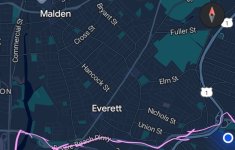
This and the Chelsea CR hits the 2nd St / Stop and Shop Redevelopment area. The 104 then goes up to Malden Ctr rather than down 16 (old route)Though I can't say for certain, I think the 104 along 2nd St is better suited to serve Everett-Chelsea demand than Revere Beach Pkwy is. If the area gets redeveloped perhaps we could see a transitway running parallel to 2nd St to speed up the buses.
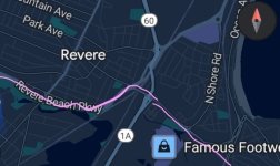
That being said, the section of Revere Beach Pkwy from Rt. 1 to Revere Center seems quite promising for a Revere/Wonderland extension of a Chelsea subway.