The Boston "what if" thread

stick n move

Superstar
Joined
Oct 14, 2009
Messages
10,307
Reaction score
11,441
Theres a lot of what if's in any city that could have changed the face of the city forever. Here you can post questions, discussions, old ideas/renderings, or photoshop your own pictures to show how something could have or should have been.


Two what if's I have always had are if they had never filled in the south bay what would it look like now. Would there be a spur of development that came and transformed it from essentially sewage into one of the jewels of Boston.

Another what if is what if back in the day I95 followed 93 but had taken a right instead of going through downtown and we had built a bridge over the harbor instead of the Ted Williams tunnell. Imagine if we had a Sydney Harbor bridge as the gateway to the city. After it went over the harbor it would follow route one and that would have essentialky been the way I95 went past Boston. It sure as hell would have given plenty of travelers a great view. Whenever I drive I95 down the coast its really cool passing by all of the major cities along the way. That essentially stops before Boston.

I dont have photoshop but I think that this would have been cool if this was built back in the day before logan, and when Logan was expanded the runway alignment would have had to have been different also allowing taller buildings in the city.


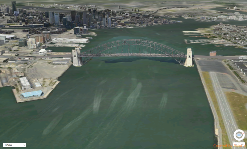
My Idea for 95 would be that it goes north up 93 turns and goes over the harbor then follows route 1 until it links back up with where 95 is now. Obviously this would not be possible now but If it had been done a long time ago I think it would have been pretty cool. Then 93 would have started as an exit near the south bay and went into the city. The zakim would have still been possible also it just would have a lot less traffic because a lot of traffic would have bypassed the city.


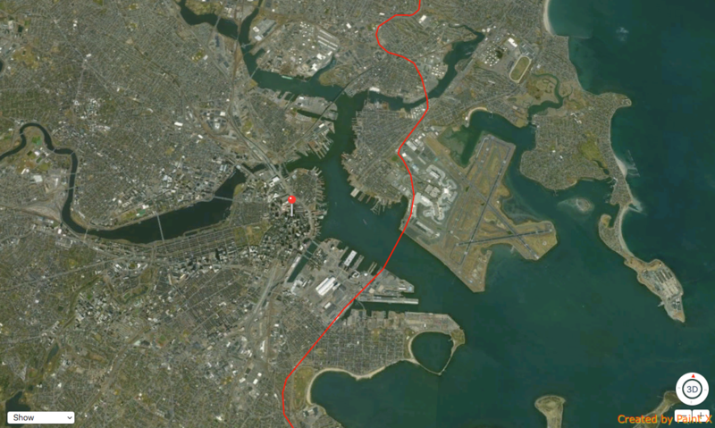
This one kind of brings the south bay and I95 idea together.
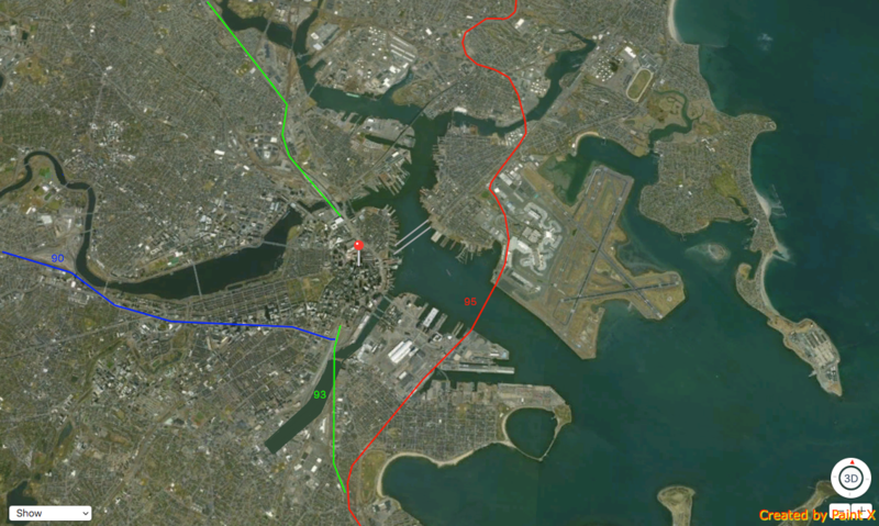
 
Last edited:
Here's another what if:
What if Brookline had accepted annexation (historically nearly happened).
Would things be much different?

How about if Cambridge had been annexed (was discussed at least)? If all the independent cities lining the harbor had been annexed?
 
If Cambridge had been annexed, I think the Inner Belt and the Northwest Expressways would have been built. Boston and the BRA in the mid 1960's were on a huge highway building binge. Cambridge, being a separate city and of a much different mindset, stopped the highway system. If it had been part of Boston, the dynamic would've been a lot different.
 
That's not necessarily true. That movement started in Cambridge, to be sure, but it was a patchwork of politics from the very local to the national that eventually killed the Inner Belt. Fred Salvucci calls it the "coalition of the unwilling" - those affected by the route didn't agree on anything else except to stop the highway. A large part of that was residents of Roxbury and Dorchester who were threatened by the Inner Belt and the Southwest Expressway.

It took two votes from the five municipalities (Cambridge, Somerville, Boston, Brookline, Milton) to halt the project - and Kevin White of Boston was the second. The real death blow was Governor Sargent issuing the ultimatum on inside-128 highway construction in 1970.
 
As I recall, having observed during the 60's the dynamics of opposition to the Inner Belt, it really was centered in Cambridge. Demolition for the Inner Belt through Roxbury, and the SW Expressway as far as Forest Hills, had already been completed. On the Somerville end, a contract had already been awarded to build the Inner Belt from I -93 almost to McGrath Highway (the contract cancelled when Gov. Sargent put on the moratorium of new expressways inside Route 128).

So, Cambridge, a small piece of Brookline, a piece of Somerville east of Union Square, and the Fenway/BU area were the only gaps in the Inner Belt not actively underway in 1969. If Cambridge had not been so opposed to the Inner Belt, I think Somerville and Brookline would have gone along with it, as the highway would have just nipped the corners of those towns.

Now, getting back to the "what if" annexation scenario, if Cambridge had been annexed by Boston in the 1800's I don't think the opposition by the people of Cambridge would have carried as much weight, as they would have just been little fish in a big pond (Boston) instead of their own feisty government. And it was very clear that the Boston City government and the BRA wanted very much to build the Inner Belt, as evidenced by all their planning maps and publications, notable the Plan for Boston 1975, published in 1965, plus the construction work already underway on the project through Roxbury.
 
Here are two off-discussed big (related) What If's.

What if 93 have never been built and what if the West End had been left intact?
Would the city have stayed in it's economic malaise that inspired those projects or would the West End have gentrified like the North End did?

I realize someone could (and probably have) write a thesis or book on this subject, but it has always fascinated me.

How much of Boston's current success is owed to those two projects?

I can't see much of Boston's current success being owed to the West End. If it wasn't wiped out, it would be an upmarket extension of Beacon Hill these days, I think.

I-93 is a very different story. Remember, it's not only through traffic and Downtown traffic that it serves, but also the Sumner and Callahan tunnels. Until 1995, it was the only access to Logan for the entire region except for the North Shore. Without it, either the 3rd Harbor Crossing would have been built decades before it was, or the airport would have moved to a location more accessible to the suburbs. Since the I-93 suburbs in the north wouldn't have been able to get to the Turnpike, I suspect Logan would have moved in the same era as Dulles, IAH, etc. were being built.

Logan being so close is huge for the inner CBD of Boston/Cambridge. Other CBDs lose office space to airport-adjacent areas (like Rosemont IL or Reston, VA). Depending on how close the new Airport was to Route 128 and its existing office belt, high tech and biotech might never have returned to Kendall and Boston.
 
What if:

In the 1950's, the Blue Line was extended to Lynn (rather than just Wonderland) as originally planned. What would Lynn be like today? Would it have more economic investment, similar to Quincy? Would it be the hipster destination of 2015? Would its population decline have been turned around earlier? Might it even have over 100,000 people today?
 
Airport travel is overrated in importance to city. It's really nice, to be sure, to have it conveniently. But the people using it frequently enough to matter are rich executives, and they can take care of themselves.

Silicon Valley has crummier airport access than Boston if you want something to compare Rt 128 to. As does Manhattan. And London. And Cambridge (UK). ;)

My hypothesis is that Boston has prospered in recent decades despite the Central Artery and urban renewal --- not because of those. Remember, the decades during and after urban renewal were shitty as hell. It wasn't until the epic (likely lead-poisoning-induced) latter-20th century crime wave faded that things turned around. Just like with other American cities. The relative density and small distances have been a boon for Boston's specific economy. The urban renewal destruction zones and highways don't really help. There's some transportation value in the highways but the problem for Boston is that highway travel doesn't scale past a certain point -- a point that was reached a while ago -- but Boston has lazily leaned on them instead of truly fixing transit and developing land use solutions that are more appropriate for the city's geography. And so we go in circles.
 
Heres an interesting what if proposal I found, with renders to boot.

MasterPlan01-Axon.jpg

MasterPlan01-Rendering-SaraZettler-JaredGuilmett.jpg

MasterPlan01-Model.jpg

MasterPlan03-Rendering.jpg

MasterPlan04-Rendering-JakeWilson.jpg

http://www.architects.org/architectureboston/articles/matter-course-reimagining-government-service-center
 
Great but I recommend tearing it down completely & starting over. Sowwy, Mr. Rudolph!
 
So...could these plans ever come to fruition in the next decade? Or is this truly a "what if" and nothing more?
 
So...could these plans ever come to fruition in the next decade? Or is this truly a "what if" and nothing more?

No. They were done in an interdisciplinary Wentworth (Hail to Thee, our Alma Mater!) design studio with the support of DCAMM, presumably for the plans of the building.
 
Last edited:
Here's another what if:
What if Brookline had accepted annexation (historically nearly happened).
Would things be much different?

How about if Cambridge had been annexed (was discussed at least)? If all the independent cities lining the harbor had been annexed?

According to the plan all municipalities within 11-12 miles of Boston's City Hall were to be annexed to the capital city. I feel with all of that under one municipality that Boston may have been like Philadelphia. Good areas, badd areas, and not enough money to go around to fix up all.
 
What if:

In the 1950's, the Blue Line was extended to Lynn (rather than just Wonderland) as originally planned. What would Lynn be like today? Would it have more economic investment, similar to Quincy? Would it be the hipster destination of 2015? Would its population decline have been turned around earlier? Might it even have over 100,000 people today?

The poor in Lynn would have been pushed further out with gentrification, less people in Lynn would opt to ride the MBTA if they had higher disposable income (i.e. like Wellesley, Newton.) then we'd be talking about the Blue Line going one more town over trying to reach people who got pushed further out.
 
Going along with my first post what if they had expanded logan much further, allowing much more height in the future, a huge amount of waterfront view real estate, and much more housing. Also what if they had connected the islands in the dorchester bay the same way they did in Eastie. A ton of housing with side on skyline views. I was going to add a bridge at the end of this "long island" type addition but realized it would interfere with the runway alignment. A tunnel would have been more appropriate.


Coupled with the bridge from my first post with the 95 extension this would have been amazing. Everything to the bottom right in this picture would have been wharves and housing.
 
So I wanted to see what it would look like if Boston had aligned the back bay when created to match the street grid and connecting it through the high spine. I honestly think it would have worked out pretty good. I highlighted the entire residential section and tilted it, then filled in the esplanade and the bottom corner to match up. Then since I was already messing around I added the south bay back in so it was like they never filled it. I connected the greenway to this new harborwalk. Then added 93 north to go over a bridge over the harbor if they had never built runway 9/27. It would be 95 and 93 would start there and go through its usual course north. The bridge I think would have worked well if like the manhattan bridge it had trains running on the lower deck and a pedestrian path on the top deck so people could walk/bike from East Boston. I moved the train yard over from the south bay and also put a bridge over fort point that would also have trains running on the lower deck. All that was extra though, the thing I wanted to see was how the brownstone section of the back bay would have aligned to the existing street grid if they had decided to connect it. It actually matched up pretty well. Route 9 would have wrapped around downtown and headed over a bridge to Cambridge.

https://postimage.org/


Heres the bridge that would have crossed the harbor.


Remember this is a what if thread not a dig up the south bay or remove 9/27 thread. Its just a what if they had gone this direction instead of that direction, how would it look.
 
I love the idea of a Boston Harbor Bridge. Too bad it would fuck up Logan.
 

Back
Top