You are using an out of date browser. It may not display this or other websites correctly.
You should upgrade or use an alternative browser.
You should upgrade or use an alternative browser.
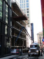
Residential Tower | 41 Lagrange Street | Chinatown
- Thread starter DZH22
- Start date


stick n move
Superstar
- Joined
- Oct 14, 2009
- Messages
- 12,078
- Reaction score
- 18,845
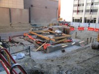
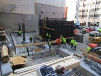
Completely forgot this was happening, nice to see it already a few floors up!
Boston02124
Senior Member
- Joined
- Sep 6, 2007
- Messages
- 6,893
- Reaction score
- 6,639
Justbuildit
Active Member
- Joined
- Nov 27, 2022
- Messages
- 859
- Reaction score
- 2,956
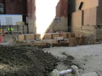
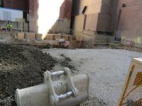
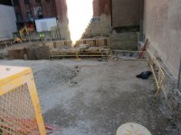
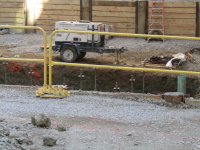
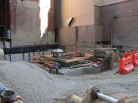
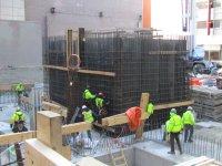
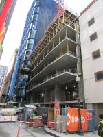
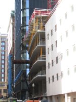
Another floor up. With some repaving and maybe one more business Lagrange might finally stop feeling like the last remnants of the combat zone

We should hope for more remnants of the combat zone. At least there were people out on the streets.Another floor up. With some repaving and maybe one more business Lagrange might finally stop feeling like the last remnants of the combat zone
View attachment 60836
Justbuildit
Active Member
- Joined
- Nov 27, 2022
- Messages
- 859
- Reaction score
- 2,956
We should hope for more remnants of the combat zone. At least there were people out on the streets.
I do not think this would be a good idea.
Downtown Boston took a massive course of antibiotics and it killed off the disease and healthy gut biome along with it. It’s a major American urban center full of closed shops and a couple of strip clubs. To go to an independent movie theater you have to go Cambridge or Brookline.I do not think this would be a good idea.
Downtown Boston took a massive course of antibiotics and it killed off the disease and healthy gut biome along with it. It’s a major American urban center full of closed shops and a couple of strip clubs. To go to an independent movie theater you have to go Cambridge or Brookline.
You start by asserting there were "more people out on the streets" during the Combat Zone era (circa 1965-2000), but of course you don't offer a shred of objective proof for this incredibly dubious proposition. You don't even bother to define geographically which "streets" you're alluding to, and why those particular ones and not others. Then you drop this vivid--but ultimately empty and meaningless--metaphor involving "antibiotics", "disease," and "healthy gut biome."
You compound the meaninglessness of your argument by putting Downtown Boston in an isolated vacuum. Yes of course Downtown has "closed shops and a couple of strips"--but to a statistically significant degree compared to peer urban markets? Finally, independent movie theaters have been dying out for decades, everywhere. So the relevance that there is one in Cambridge or Brookline, relative to Downtown is... what exactly?
In short: your reactionary, context-free raving here is almost as bad as anything Rifleman ever spewed...
look at this dummyYou start by asserting there were "more people out on the streets" during the Combat Zone era (circa 1965-2000), but of course you don't offer a shred of objective proof for this incredibly dubious proposition. You don't even bother to define geographically which "streets" you're alluding to, and why those particular ones and not others. Then you drop this vivid--but ultimately empty and meaningless--metaphor involving "antibiotics", "disease," and "healthy gut biome."
You compound the meaninglessness of your argument by putting Downtown Boston in an isolated vacuum. Yes of course Downtown has "closed shops and a couple of strips"--but to a statistically significant degree compared to peer urban markets? Finally, independent movie theaters have been dying out for decades, everywhere. So the relevance that there is one in Cambridge or Brookline, relative to Downtown is... what exactly?
In short: your reactionary, context-free raving here is almost as bad as anything Rifleman ever spewed...
BostonObserver
Active Member
- Joined
- Dec 26, 2006
- Messages
- 573
- Reaction score
- 103
The vast majority of crime in the combat zone occurred on LaGrange Street. Ever been to Boston jeremi? I doubt it.
A bit of history of this location:
(project site marked by red dot)
19th Century
Lagrange Street almost certainly owes its name to the Château de la Grange-Bléneau, the castle of the Marquis de Lafayette. The famous Revolutionary War hero had visited Boston on several occasions, the most recent during his grand tour of the United States in 1824-1825, and it was a common practice in the country during that period to name places after both him and the chateau. In 1828 Lagrange (or La Grange) Place was laid out as a side alley off Washington Street on the site of a former distillery. In 1864 it was extended west to Tremont Street, and in the following year it was named Lagrange Street.
During these early years the street was primarily built up with rowhouses reflecting early 19th-century styles. These were joined in the middle decades of the century by the headquarters of District 4 of the Boston Police Department, a Second Empire building built on the south side of the street. Initially the north and south sides of the street were respectively given even and odd numbers, and 41-45 Lagrange was numbered as 18-20. At some point between 1874 and 1883 the convention was flipped, and the project site received its present address.
Boston in 1814, prior to the formation of Lagrange Place

Lagrange Place in 1852, prior to its extension to Tremont Street


Boston Police Department Station 4, south side of Lagrange Street, late 19th century. This station remained open until 1933, when Districts 4 merged with District 5 and relocated to the South End

----
Late 19th / Early 20th Centuries
By the last decade of the 1800s Lagrange Street was still mostly occupied by rowhouses, although they had been increasingly given over to commercial use. In 1875 the famous architect H.H. Richardson designed the Romanesque Hayden Building at the southwest corner of Washington and Lagrange Streets (his only commercial building still extant in Boston). In 1895 construction of the new Hotel Touraine began on the block of Tremont Street between Boylston and Lagrange; at the same time several rowhouses on the north side of the street were redeveloped into a working quarters annex for the new building. In 1908 Essex Station, serving the Washington Street Tunnel, was opened, and a side entrance was built at 12-18 Lagrange. In 1925 the United Savings Bank began erecting a new building at the southeast corner of Tremont and Lagrange.
Meanwhile, the surrounding area thrived. Both Washington and Tremont Streets in the vicinity of Lagrange were hubs of commercial activity, with department stores, office buildings, hotels, dining establishments, and small shops operating there. The area also increasingly gave itself over to entertainment as it became a part of the expanding Theater District, with the Lyceum (later Gaiety), Olympia, Globe, and Unique Theatres present on Washington Street and the Majestic Theatre on Tremont Street. Old buildings regularly gave way to new construction during this period.
North side of Lagrange Street, 1905

East side of Tremont Street (left - prior to the construction of the Hotel Touraine) & north side of Lagrange Street (right), ca. 1895. 41-45 Lagrange Street are just off the frame at the far right

West side of Washington Street, with head of Lagrange Street on center-right, 1904. Hayden Building in center

West side of Washington Street, 1904; Lyceum Theatre on right. Lagrange Street is just out of frame to the left. Boylston Building (which replaced the Boylston Market) on right

Map of Boston in 1896, showing new Servants' Quarters for the Hotel Touraine on Lagrange Street

14-18 Lagrange Street, showing new entrance to Essex Street Station, ca. 1908. The building on the right is now home to Centerfolds

----
Mid / Late 20th Century
In the middle decades of the 20th century, the area around Lagrange Street began to develop a reputation as an increasingly seedy neighborhood, home to prostitution and adult entertainment establishments. This trend heavily accelerated after the demolition in Scollay Square in 1962, which resulted in the former businesses there relocating to this section of the city. By the end of the decade the area was thoroughly given over to adult nightclubs, bars, late night dining options, and adult bookstores and movie houses.
As early as 1951, the area had begun to occasionally be known as a "Combat Zone," and by 1965 the label had firmly stuck to the area of Washington Street between Boylston and Stuart Streets. In 1974 the city officially designated to Combat Zone as an adult entertainment district in an attempt to limit its illicit activities from spreading elsewhere.
Located exactly in the middle of the Combat Zone, Lagrange Street was heavily affected by the new environment. Those buildings that managed to avoid demolition during this period became home to prostitutes, clubs, bars, and bookstores. The transformation of Lagrange into an adult district was so complete that a 1990 Globe article characterized it Boston's "Street of Shame" and described it as "lined by night with prostitutes who operated out of its bars and strip clubs" between the 1960s and 1980s.
Washington Street looking north, ca. 1954-1959. Head of Lagrange Street on left

Aerial view, ca. 1954-1959, showing the increasing prevalence of parking lots in the neighborhood

Front page of an article about the Combat Zone, 1966

The Combat Zone: West side of Washington Street, ca. 1970-1985. Lagrange Street and Hayden building on left

Establishments that operated in the Combat Zone

North side of Lagrange Street, 1979. Good Time Charlie's, at 25 Lagrange Street, was one of the most notorious bars in the Combat Zone

Activity on Lagrange Street, 1975

Late 20th / Early 21st Centuries
By the final years of the 20th century, the Combat Zone declined as a result of public pressure, rising property values, and the proliferation of home entertainment systems. As of today two establishments on Lagrange Street, Centerfolds and the Glass Slipper, are all that remains of the old district.
Further transformations of Lagrange Street have come through new development. In 2012 The Kensington was built, followed in 2015 by LUKA on the Common and in 2022 by The Parker.
The Kensington

LUKA on the Common

The Parker

(project site marked by red dot)
19th Century
Lagrange Street almost certainly owes its name to the Château de la Grange-Bléneau, the castle of the Marquis de Lafayette. The famous Revolutionary War hero had visited Boston on several occasions, the most recent during his grand tour of the United States in 1824-1825, and it was a common practice in the country during that period to name places after both him and the chateau. In 1828 Lagrange (or La Grange) Place was laid out as a side alley off Washington Street on the site of a former distillery. In 1864 it was extended west to Tremont Street, and in the following year it was named Lagrange Street.
During these early years the street was primarily built up with rowhouses reflecting early 19th-century styles. These were joined in the middle decades of the century by the headquarters of District 4 of the Boston Police Department, a Second Empire building built on the south side of the street. Initially the north and south sides of the street were respectively given even and odd numbers, and 41-45 Lagrange was numbered as 18-20. At some point between 1874 and 1883 the convention was flipped, and the project site received its present address.
Boston in 1814, prior to the formation of Lagrange Place
Lagrange Place in 1852, prior to its extension to Tremont Street
Boston in 1866. Prominent buildings visible include the United States Hotel and terminal of the Boston & Worcester Railroad (top left), the original St. James Church (top right), the old Thirteenth Congregational Church, Boylston Market, the old Masonic Temple, and the old Boston Public Library (middle left), and the terminal of the Boston & Providence Railroad (lower right)Boston Police Department Station 4, south side of Lagrange Street, late 19th century. This station remained open until 1933, when Districts 4 merged with District 5 and relocated to the South End
----
Late 19th / Early 20th Centuries
By the last decade of the 1800s Lagrange Street was still mostly occupied by rowhouses, although they had been increasingly given over to commercial use. In 1875 the famous architect H.H. Richardson designed the Romanesque Hayden Building at the southwest corner of Washington and Lagrange Streets (his only commercial building still extant in Boston). In 1895 construction of the new Hotel Touraine began on the block of Tremont Street between Boylston and Lagrange; at the same time several rowhouses on the north side of the street were redeveloped into a working quarters annex for the new building. In 1908 Essex Station, serving the Washington Street Tunnel, was opened, and a side entrance was built at 12-18 Lagrange. In 1925 the United Savings Bank began erecting a new building at the southeast corner of Tremont and Lagrange.
Meanwhile, the surrounding area thrived. Both Washington and Tremont Streets in the vicinity of Lagrange were hubs of commercial activity, with department stores, office buildings, hotels, dining establishments, and small shops operating there. The area also increasingly gave itself over to entertainment as it became a part of the expanding Theater District, with the Lyceum (later Gaiety), Olympia, Globe, and Unique Theatres present on Washington Street and the Majestic Theatre on Tremont Street. Old buildings regularly gave way to new construction during this period.
North side of Lagrange Street, 1905
East side of Tremont Street (left - prior to the construction of the Hotel Touraine) & north side of Lagrange Street (right), ca. 1895. 41-45 Lagrange Street are just off the frame at the far right
West side of Washington Street, with head of Lagrange Street on center-right, 1904. Hayden Building in center
West side of Washington Street, 1904; Lyceum Theatre on right. Lagrange Street is just out of frame to the left. Boylston Building (which replaced the Boylston Market) on right
Map of Boston in 1896, showing new Servants' Quarters for the Hotel Touraine on Lagrange Street
14-18 Lagrange Street, showing new entrance to Essex Street Station, ca. 1908. The building on the right is now home to Centerfolds
----
Mid / Late 20th Century
In the middle decades of the 20th century, the area around Lagrange Street began to develop a reputation as an increasingly seedy neighborhood, home to prostitution and adult entertainment establishments. This trend heavily accelerated after the demolition in Scollay Square in 1962, which resulted in the former businesses there relocating to this section of the city. By the end of the decade the area was thoroughly given over to adult nightclubs, bars, late night dining options, and adult bookstores and movie houses.
As early as 1951, the area had begun to occasionally be known as a "Combat Zone," and by 1965 the label had firmly stuck to the area of Washington Street between Boylston and Stuart Streets. In 1974 the city officially designated to Combat Zone as an adult entertainment district in an attempt to limit its illicit activities from spreading elsewhere.
Located exactly in the middle of the Combat Zone, Lagrange Street was heavily affected by the new environment. Those buildings that managed to avoid demolition during this period became home to prostitutes, clubs, bars, and bookstores. The transformation of Lagrange into an adult district was so complete that a 1990 Globe article characterized it Boston's "Street of Shame" and described it as "lined by night with prostitutes who operated out of its bars and strip clubs" between the 1960s and 1980s.
Washington Street looking north, ca. 1954-1959. Head of Lagrange Street on left
Aerial view, ca. 1954-1959, showing the increasing prevalence of parking lots in the neighborhood
Front page of an article about the Combat Zone, 1966
The Combat Zone: West side of Washington Street, ca. 1970-1985. Lagrange Street and Hayden building on left
Establishments that operated in the Combat Zone
North side of Lagrange Street, 1979. Good Time Charlie's, at 25 Lagrange Street, was one of the most notorious bars in the Combat Zone
Activity on Lagrange Street, 1975
Late 20th / Early 21st Centuries
By the final years of the 20th century, the Combat Zone declined as a result of public pressure, rising property values, and the proliferation of home entertainment systems. As of today two establishments on Lagrange Street, Centerfolds and the Glass Slipper, are all that remains of the old district.
Further transformations of Lagrange Street have come through new development. In 2012 The Kensington was built, followed in 2015 by LUKA on the Common and in 2022 by The Parker.
The Kensington
LUKA on the Common
The Parker
Last edited:
What a great post. Thank you. Makes me want to visit here more often.
Sad to see so many mediocre additions to our fair city. I love this place and wish that modernity was not so nibbling away at what makes Boston unique. Cities must grow, it's true, or they die. Not everything new can be perfect. Not everything old can be saved. It's a delicate balance.
I can't help but feel we need to take better care. To me, those last pictures show why. Clean, efficient and new, yes. Generic and meaningless as well.
I complain a lot, I know. But once gone, gone forever.
Last edited:
HenryAlan
Senior Member
- Joined
- Dec 15, 2009
- Messages
- 4,184
- Reaction score
- 4,450
A bit of history of this location:
Amazing write-up, and I especially appreciate some of the maps and pictures. These three are my favorite:
1) I wonder what Boston would be like if all parts of the original Shawmut peninsula had been preserved in this state. As amazing a place as it is today, imagine an area 5-6 times the size of the North End or Beacon Hill with similar rich features.
Boston in 1866. Prominent buildings visible include the United States Hotel and terminal of the Boston & Worcester Railroad (top left), the original St. James Church (top right), the old Thirteenth Congregational Church, Boylston Market, the old Masonic Temple, and the old Boston Public Library (middle left), and the terminal of the Boston & Providence Railroad (lower right)
2) But this is also an amazing era. I love the noir aesthetic, and this image captures it perfectly.
Washington Street looking north, ca. 1954-1959. Head of Lagrange Street on left
3) And finally, a fantastic source document showing contemporary attitudes of the '60s, and such a nicely written piece, could almost be the work of Raymond Chandler.
Front page of an article about the Combat Zone, 1966
jjdemello123@gmail.com
Active Member
- Joined
- Jul 16, 2019
- Messages
- 114
- Reaction score
- 918
A bit of history of this location:
A lot of great information and great posts have come out of aB over the years. This post is top 5 all time (IMO). Thanks for sharing.