Boston Harbor Flood Protection Projects

The city knows what it needs to pay for because it is a national leader in resilience planning. Thanks to the 2016 Climate Ready Boston report and subsequent neighborhood-level plans, Boston has comprehensive plans for the entire waterfront and an active set of near-term projects in the most urgent areas. These include installing a berm at Ryan Playground to protect Charlestown and creating short- and long-term strategies for Long Wharf, one of the city’s most vulnerable flood pathways.
The city owns 16 percent of the waterfront; 50 percent is owned by the state, and 30 percent is owned by the private sector, making collaboration across ownerships key to get us to scale. So far, primarily city-owned parks and new private development along Fort Point Channel have been built.
In the private sector, lenders increasingly are asking real estate developers not only how they are incorporating flood protection into their development projects but also how their neighbors have done so and what the impact of neighborhood flood planning will be on their developments.
The city of Boston’s setting aside $75 million for resilience capital investments is a critical first step on funding, and the Healey administration’s Mass Ready Act is a statewide bill that includes a “Resilience Revolving Fund” of low- or no-cost loans to municipalities and expanded authorization of funding for the state’s Municipal Vulnerability Preparedness Program.
 
I guess this goes here:

IMG_5009.jpeg

1768838976990.jpeg

1768838636926.png

1768838699547.png


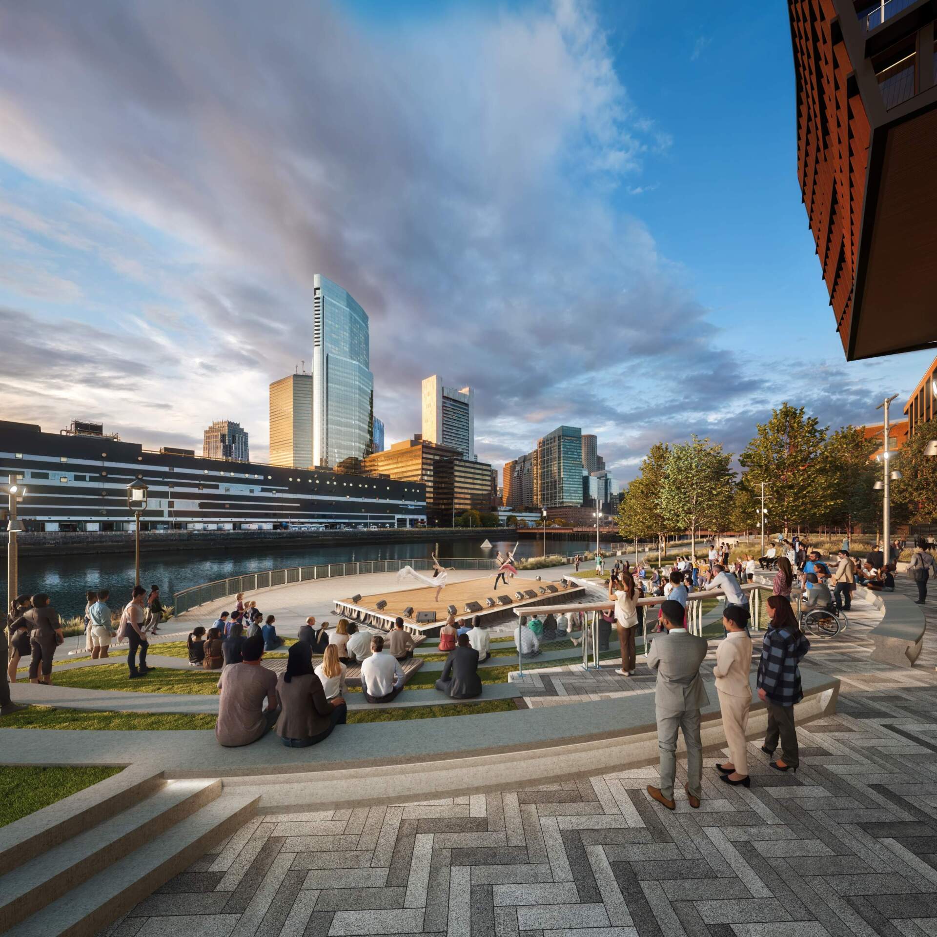
“The dream: a public amphitheater, right by the water. There, 1,000 people could enjoy free public performances by big and small cultural organizations from all over, including Boston Ballet, Boston Lyric Opera, Commonwealth Shakespeare Company, Urbanity Dance, and Circus Up, among many others.

It would be a place where anybody who wants to could put on a show. The amphitheater would include lighting and power on site, which would make performing cheaper and simpler.

The proposal comes after years of public discussions and planning between the city and Related Beal, the company developing the site, and a huge consortium of arts groups who have joined forces to push for something ambitious there.

“Everyone came together to say, ‘Hey, we can do something bigger and better together, to benefit not just us, but this region, for generations,’” said Bradley Vernatter, CEO of Boston Lyric Opera. “You can see how this creates ... an opportunity, and a hope and joy, that is much bigger than any of us can do on our own.”

The design also includes a proper dock, a place to launch canoes, dragon boats, and artwork into the water easily, part of a wider plan to bring the entire Fort Point Channel to life……”


Looks like updates are coming for a comprehensive flood resiliency plan in collaboration with the feds. Announcement and details will be available this afternoon:


Summary here, presumably will be updated once the full plan is out on Friday 7/24:

 
Last edited:
It basically sounds like theyre going with the same approach new orleans took pre katrina to build extensive levies/sea walls around the entire perimeter of the city

IMG_6085.jpeg


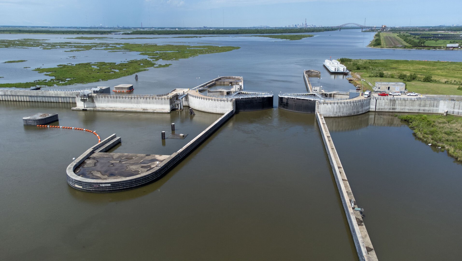
Vs what new orleans did post katrina where instead of dozens of miles of levies/sea walls they built one massive flood wall/gates at the entrance of the intracoastal waterway to new orleans to block storm surge before it ever even gets to the city.
IMG_6086.jpeg


One large concentrated megaproject in one spot vs dozens of much smaller projects spread around the city that can be phased in over time as funding is available. I understand why its tempting to go with the first option, but it creates so many more failure points and maintenance points over time vs the single concentrated megaproject.
 
Last edited:
It basically sounds like theyre going with the same approach new orleans took pre katrina to build extensive levies/sea walls around the entire perimeter of the city

View attachment 74229


Vs what new orleans did post katrina where instead of dozens of miles of levies/sea walls they built one massive flood wall/gates at the entrance of the intracoastal waterway to new orleans to block storm surge before it ever even gets to the city.
View attachment 74228

One large concentrated megaproject in one spot vs dozens of much smaller projects spread around the city that can be phased in over time as funding is available. I understand why its tempting to go with the first option, but it creates so many more failure points and maintenance points over time vs the single concentrated megaproject.
Your harbor barrier mega project only works if you also fortify the coast north and south of your mega dike. Otherwise you just get an end run flood situation that fills the harbor from either side of the barrier, and still floods all of the susceptible areas.
 
Your harbor barrier mega project only works if you also fortify the coast north and south of your mega dike. Otherwise you just get an end run flood situation that fills the harbor from either side of the barrier, and still floods all of the susceptible areas.
still makes more sense than trying to fortify the every inch of the city that meets the water. Doing that successfully seems impossible to me.
Boston/Cambridge/Somerville/Medford/Everett/Chelsea/Winthrop all have to build levies on every foot of coastline within the general harbor area, and there's Logan.
 
I guess this goes here:

View attachment 70171
View attachment 70173
View attachment 70170
View attachment 70172

“The dream: a public amphitheater, right by the water. There, 1,000 people could enjoy free public performances by big and small cultural organizations from all over, including Boston Ballet, Boston Lyric Opera, Commonwealth Shakespeare Company, Urbanity Dance, and Circus Up, among many others.

It would be a place where anybody who wants to could put on a show. The amphitheater would include lighting and power on site, which would make performing cheaper and simpler.

The proposal comes after years of public discussions and planning between the city and Related Beal, the company developing the site, and a huge consortium of arts groups who have joined forces to push for something ambitious there.

“Everyone came together to say, ‘Hey, we can do something bigger and better together, to benefit not just us, but this region, for generations,’” said Bradley Vernatter, CEO of Boston Lyric Opera. “You can see how this creates ... an opportunity, and a hope and joy, that is much bigger than any of us can do on our own.”

The design also includes a proper dock, a place to launch canoes, dragon boats, and artwork into the water easily, part of a wider plan to bring the entire Fort Point Channel to life……”


Good god, how did I miss this? (Probably because it should be in the Seaport infill thread. Can a mod move it?) Regardless, this is beautiful and could become an iconic space. Not quite the Bregenzer Fespiele, but a modest little tribute:

images

 
Your harbor barrier mega project only works if you also fortify the coast north and south of your mega dike. Otherwise you just get an end run flood situation that fills the harbor from either side of the barrier, and still floods all of the susceptible areas.
Isn't the primary concern about Boston flooding related to intense floodwater hitting right at the oldest, most developed parts of the city where there's lots of underground or at-grade legacy infrastructure right up against the water/flood zones and the highest density of residential housing as well as critical infrastructure like hospitals? If you block the downtown via this Hull/Deer Island Dike, but then have water start creeping in from the outer extremes beyond the dike (i.e. Rumney Marsh, Cohasset), doesn't that still allow those lower-density outlying areas (and natural marshlands) to more easily absorb (and recover from) water infiltration before it begins affecting the underground T and power lines going to MGH, etc?
 
Isn't the primary concern about Boston flooding related to intense floodwater hitting right at the oldest, most developed parts of the city where there's lots of underground or at-grade legacy infrastructure right up against the water/flood zones and the highest density of residential housing as well as critical infrastructure like hospitals? If you block the downtown via this Hull/Deer Island Dike, but then have water start creeping in from the outer extremes beyond the dike (i.e. Rumney Marsh, Cohasset), doesn't that still allow those lower-density outlying areas (and natural marshlands) to more easily absorb (and recover from) water infiltration before it begins affecting the underground T and power lines going to MGH, etc?
With the kinds of storm surges anticipated, the surge is not going to just go through Rumney Marsh or Hingham. Those surges will breach and likely wipe out low-lying parts of Winthrop and Hull -- creating clear paths into the harbor. Unless you seriously reinforce Winthrop and Hull you have a solid wall with big screen doors on either side.

If Winthrop and Hull are sufficiently protected, then your plan to use the marshes as buffers likely works.
 
With the kinds of storm surges anticipated, the surge is not going to just go through Rumney Marsh or Hingham. Those surges will breach and likely wipe out low-lying parts of Winthrop and Hull -- creating clear paths into the harbor. Unless you seriously reinforce Winthrop and Hull you have a solid wall with big screen doors on either side.

If Winthrop and Hull are sufficiently protected, then your plan to use the marshes as buffers likely works.
The "build extensive levies/sea walls around the entire perimeter of the city" plan would also require this sort of reinforcement, but on a much larger scale, everywhere, with more points of failure, right?
 
With the kinds of storm surges anticipated, the surge is not going to just go through Rumney Marsh or Hingham. Those surges will breach and likely wipe out low-lying parts of Winthrop and Hull -- creating clear paths into the harbor. Unless you seriously reinforce Winthrop and Hull you have a solid wall with big screen doors on either side.

If Winthrop and Hull are sufficiently protected, then your plan to use the marshes as buffers likely works.
Yes, @stick n move 's drawing for the megaproject is inaccurate. It should have also included lines along Hull, Winthrop, and probably Revere, at least on the Atlantic sides.

But I think their point is pretty clear. One ~3-mile megaproject dyke from Hull to Deer Island could be built instead of trying to fix up maybe 70 miles of shoreline inside that point.
 
Yea I wasnt going for complete accuracy, it was more a quick scribble just to drive the point home about putting seawalls around the entire city vs the biggest single point of failure new orleans style pre and post katrina. Either way yea itd be closer to something like this:

IMG_6092.jpeg
 
Last edited:
Yes, @stick n move 's drawing for the megaproject is inaccurate. It should have also included lines along Hull, Winthrop, and probably Revere, at least on the Atlantic sides.

But I think their point is pretty clear. One ~3-mile megaproject dyke from Hull to Deer Island could be built instead of trying to fix up maybe 70 miles of shoreline inside that point.
To do this right, it is more like a 20 mile mega project, but still seems more effective than trying to patchwork 70 miles of complex shoreline inside the harbor area.

The harbor portion of the dike is pretty complex to allow for tidal flushing of the harbor, and large ship traffic, but the Dutch have engineered similar systems, so it is definitely doable. The Maeslantkering (Maeslant Storm Surge Barrier) near Rotterdam is a good example.
 
This is the federal bureau that created the Katrina situation - right? And the one that is so intransient about the Cape Cod Canal crossings? Are we surprised that they came up with this monstruosity of an engineering project?
 

Back
Top