Boston Harbor Flood Protection Projects

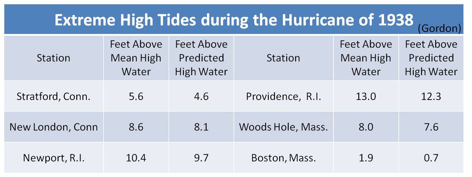
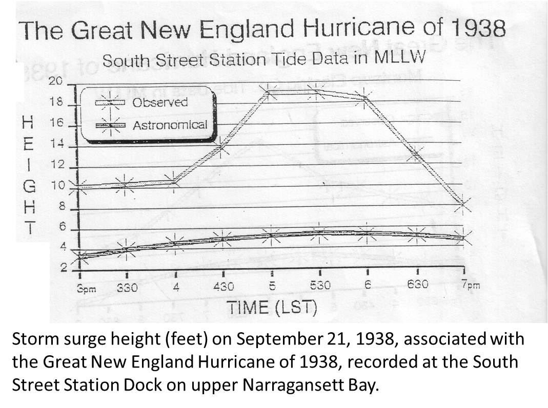
When measuring storm surge in a hurricane in the Northern hemisphere, the highest surge values are on the right-side quadrants of a hurricane .that is traveling poleward. The highest storm surges produced by the Great Hurricane of 1938 are shown in the images below.

1938_hurricane_storm_surge_gordon.JPG


1938_hurricane_tide_south_street_station.jpg


The referenced South Street Station dock is at 360 Eddy St. in Providence. What happened in Providence in 1938 is similar, from a phenomenon standpoint, to what happened t in Tampa Bay during Helene. There was no surge in Tampa Bay during Milton.

One would be hard-pressed to develop a scenario where a hurricane would generate a storm surge of 15 feet in Boston Harbor, or on any community facing Massachusetts Bay. Also a hurricane is not a Nor'easter, Sandy's storm surge along the east-facing shoreline of Massachusetts Bay was 2.5-4.5 feet. On the south coast of Massachusetts, Sandy's surge was 4-6 feet. While Sandy and historic nor'easters generated waves of 25 feet in Massachusetts Bay, Boston Harbor is not Scituate
Wouldn't that mean you want a hurricane to track immediately west of Boston to put Boston on the right-hand side of a hurricane? Such a track would put Boston in roughly the same location as Tampa Bay in Helene, or Port Charlotte in Milton. You'd also want a track where the hurricane is pointing due north or NNW.
 
Wouldn't that mean you want a hurricane to track immediately west of Boston to put Boston on the right-hand side of a hurricane? Such a track would put Boston in roughly the same location as Tampa Bay in Helene, or Port Charlotte in Milton. You'd also want a track where the hurricane is pointing due north or NNW.

I'm no meteorologist but while such a scenario is possible, it would still mean Boston wouldn't get the worst storm surge because the storm would be weakened by making landfall somewhere around Providence/FR/NB
 
Wouldn't that mean you want a hurricane to track immediately west of Boston to put Boston on the right-hand side of a hurricane? Such a track would put Boston in roughly the same location as Tampa Bay in Helene, or Port Charlotte in Milton. You'd also want a track where the hurricane is pointing due north or NNW.
Hurricane Helene tracked 100 miles to the west of Tampa in the Gulf of Mexico. The Great Hurricane of 1938 made a first landfall in Long Island, and a second landfall near Milford CT. The 1938 Hurricane then tracked to the west of Hartford and Springfield. For a storm surge, a hurricane's right-side quadrants need to be tracking over open water, not over forests and fields. Providence experienced a devastating storm surge because the right-side quadrants of the 1938 hurricane's eye pushed water up Narragansett Bay, about 100 miles east of the CT landfall, and when that surge reached Providence at the northern end of Narragansett Bay, it had no where to go but up.

Because Milton crossed Florida about 70 miles south of Tampa, water was sucked out of Tampa Bay.. The water level in Tampa Bay temporarily dropped by about five feet.
https://apnews.com/article/hurricane-milton-tampa-bay-reverse-surge-3ac00f9d341d6ec5fa024af253f5bdc1

In the Great Hurricane of 1938, the highest recorded wind gust was 186 mph at Blue Hill. The highest waves were 50 feet at Gloucester. Those measurements reflect another hurricane phenomenon. The forward speed of a hurricane tracking northward is added to a hurricane's peak sustained wind in the right quadrants of a hurricane and substracted from the left quadrants. The forward speed of the 1938 hurricane was calculated at 47 mph as it traveled over New England. If the sustained wind of the 1938 Hurricane was 100 mph at Milford CT., the sustained wind at New Haven might be 147 mph, while the sustained wind at Stamford, on the left side of the eye, might be 53 mph.
 
Communities along Buzzards Bay (further east away from the Long Island/CT landfall) also experienced a devastating storm surge during the 1938 hurricane, causing much damage in towns like Wareham and Bourne. As noted by others, the hurricane traveling over open water pushed water up into the bays and inlets east of landfall, with damage as far east as the Cape.
 

Back
Top