Back Bay Infill project - 1869 (request for help)

I

IMAngry

Guest
Hey.

I am reading a book on the infilling (w/e) of the Back Bay - the newer one by the guys from Northeastern, and found out something I didn't know before.

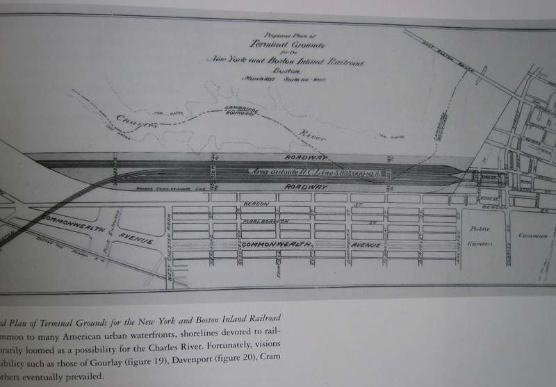
Apparently, there were plans to continue filling in the Back Bay, by expanding the land into the Charles River, covering the area to the right and left of the Longfellow Bridge. The plan was proposed in 1869, but, obviously, never attempted or completed.

Does anyone have any other information on this? There was a very small photo of the plan, courtesy of the Commonwealth's library, but I was hoping to find some of the maps and plans, online.

I am fascinated by this. There were at least four new roads, branching out from the Museum of Science area, past the Longfellow bridge, and a bit further toward the Hatch shell. It seems to have filled in a lot of the Charles River, in this area.

Any information would be greatly appreciated.

(Let's do this now! Haha.)
 
When Storrow Drive was built, some additional landfilling did occur, in an attempt to compensate for the lost parkland. I believe the islands were created at that time.
 
...

i also recall another proposal to put an island neighborhood in the middle of the charles around the mass. ave bridge.
 
That was by Ralph Adams Cram, proposed around the same time that MIT was building its initial campus. There's a birds-eye view of the proposal in the book Mapping Boston.
 
And what's now the MIT campus was originally intended to be a fancy residential neighborhood, similar to what was built across the river. A few alphabetical streets (Danforth, Endicott, Fowler) are reminders of this, as are the former hotels and apartment buildings now used as MIT dormitories -- Burton House, Ashdown House, and Bexley Hall.
 
Wow, that's great. I never knew about any of these proposals. An island community in the middle of the Charles?? That is ludicrous, but I kind of like the idea for some reason. It reminds me of playing Sim City. Adding islands and what not just to make a city cool and interesting looking.
 
If the idea was to emulate classical European cities (ie Paris) then an island makes a lot of sense.
 
Apparently, I'm lazy?

Inventing the Charles River, pp. 77-80

In the fall of 1869, for reasons that remain obscure, a bill was presented to the General court to approve substantial additional fill north of the new seawall on the water side of Beacon Street, in the main channel of the lower Charles. Hearings on the bill called forth vociferous protests from some of the city's most prominent citizens and established for the next thirty years the terms for public discourse on the river as a public space.

...

Led by Oliver Wendell Holmes, the witnesses at the Charles River hearings outlined all the arguments for developing the river as a water park - though it would be more than thirty years before the first steps were taken to that end.

...

The chairman announced at the first hearing that the committee would assume that the flats from the West Boston Bridge to the cross dam would be filled for a distance of fourteen hundred feet from the shore, reducing the channel of the river to between three and five hundred feet.

...

Following introductory presentations by counsel for the opponents, various experts testified against the scheme. The engineering authorities described how shoaling in the harbor would increase. Medical doctors described the spread of disease that would follow and presented statistics on mortality. Real estate brokers enumerated the precipitous decline in property values on the water side of Brimmer and Beacon Streets, because of the loss of fresh air and the view of the water and the country beyond. And, the community's loss of trust in the state's prior commitments would be shattered.

So, nothing was every done.

Years later, as most readers of this forum know, Storrow Drive and the Esplanade was created on the other side of the Mill Dam and the seawall (the seawall still in plain site along the edge of the outbound lanes).

I've got another, better question. How come the MDC (w/e) doesn't block off the lagoon on the Esplanade to allow for ice skating?
 
To the Question about the MDC not allowing skating, i have a simple/ yet unfortunate answer...

First, it's the DCR that's in control of that area now (Department of Conservation and Recreation) which is a combination of of the old DEM (Department of Environmental Management) and MDC. Not that it should be expected to know that because the name changes regularly.

I work for the DCR and the issue is simply, money, staffing (an issue w/ direct ties to money), and risk of lawsuit. They don't open that area to skating because the don't want to pay to staff another area, and run the risk of lawsuits because the DCR (whom i work for in region 3, South Shore) has a strict CYA (cover your ass) policy. if they can avoid any situation where they can lose money, they will. in the case of skating on the lagoon, they simply avoid it to save money.
 
Where do you work for the DCR? I used to be a DEM interpreter at a couple of state parks a few years back...
 
I'm at the Freetown State Forest right now. but i split time at Dighton Rock and Horseneck Beach sometimes too.
 
Here's a pic of the Cram island proposal, looking east


And another proposal that fortunately never went through

 
Wow.... that's fascinating. it would be interesting to see (had that ever been built) how it would look today.
 
Had it been built, I doubt it would've come out looking as downright Parisian as it does, for by the time the land would have been made and the lots put up for sale (teens/twenties), the market for townhomes in the city had died out (e.g. Bay State Rd). Perhaps something this grand could have bucked the trend of moving out to the first-ring suburbs, but I'm guessing if it were around today it would be mostly made up of decently ornamented walk-ups, not luxurious mansions.
 
^In other words, it would have been a terrific neighborhood in a great location
 
I've always thought that the wideness of the Charles where the Harvard Bridge crosses it is really beautiful. But....I'd be willing to give it up for that island proposal. It's a slice of Paris complete with a cathedral, palace, monumental plaza, wide parisian avenue, landscaped gardens....what more could you ask for?
 
lexicon506 said:
I've always thought that the wideness of the Charles where the Harvard Bridge crosses it is really beautiful. But....I'd be willing to give it up for that island proposal.
Agreed. Once in a great while a proposal comes along to make an already-beautiful place even better. This is one of those.

Boston needs to start thinking like this again.
 

Back
Top