Biking the Boston 'Burbs (Trails, MDC, & Towns beyond Hubway area)

Is this all contingent on MassHighway building the replacement river crossing and snaking a ped underpass at the riverbank?
I appears so. Happily that work is underway.

Do either of these pictures clarify? Seems like a big part (but not all) of the solution is how paths are routed above and under the new bridge now being built at Wellington. I believe the "under" portion does include two water-level bridge underpasses on either side of the river.

From a large metro-wide plan from 2012
NEW_map_bikes__1341717004_3915.jpg


From Everett's original Northern Strand Plan (this seems a decent map):
NorthernStrandMap.gif


^This seems to pre-date (or not assume) the Malden River Bridge replacement, but given the river bridge, it seems getting to Wellington is within reach.
 
Last edited:
Court ruling pertaining to the Newton Lower Falls right-of-way between Wellesley and Riverside.

I don't know what the prospects for turning this into a trail are, but this would seem to be not bad news, at least.

I'd call it officially good news. It means that the ROW that the MBTA bought is still continuous and its easements are still in force and that NIMBYs cannot extend their backyard to sever the ROW.

This will be a great trail project. Supporters have a nice site:
http://www.newtonconservators.org/railroadbridge.htm
railbridgetrailmap.jpg
(and PDF brochure)

It includes two important bike-only bridges, one across the Charles from Wellesley into Newton (though its technically Newton on both sides) and another across 128 on a span that's still there
P1100833_1.JPG


That span over 128 means that Newton Lower Falls will have an easy walk (.5 mi) to Riverside and Papa Razzi will have a 1mi bike ride, with the Northwest tip of Wellesley being easily bikable (if you can handle hills)
 
Would also connect Riverside to the Acqueduct path system. Although they've got a lot of path miles left to string together there. At minimum it's very little additional work on the Acqueduct side to get from this new trail head @ Route 16 to Wellesley Hills.
 
It includes two important bike-only bridges, one across the Charles from Wellesley into Newton (though its technically Newton on both sides) and another across 128 on a span that's still there.

That span over 128 means that Newton Lower Falls will have an easy walk (.5 mi) to Riverside and Papa Razzi will have a 1mi bike ride, with the Northwest tip of Wellesley being easily bikable (if you can handle hills)

Not sure if you meant this, but the bridge of the Charles has been rehabbed and open for years as the first phase of the project. I'd also hardly call the three bridges (there are actually two 128 spans - one over the mainline and one over the access road) "bike only". I've never seen a bike on the river bridge, and I suspect that about 95% of the traffic on this trail will be on foot, if not more, especially since it will be covered in soft gravel.

They call this the "bike path" around the neighborhood, too, but I don't think it's really going to act like one. However, the dumbbell of CVS and Wellesley LF on one end and the Riverside Development on the other (maybe, at some point) will be huge for Lower Falls.

Would also connect Riverside to the Acqueduct path system. Although they've got a lot of path miles left to string together there. At minimum it's very little additional work on the Acqueduct side to get from this new trail head @ Route 16 to Wellesley Hills.

I believe that the plan has been to street-run it up Route 16 with signage, but no dedicated bike lane. In the long run, it's the Quinobequin Rd. path that's the next big deal, to bring a disjointed connection to Hemlock Gorge.
 
^Yes to all that bridge & modal detail. I was simplifying. And the universal reality is that every "bike path" with any significant number of abutting residences & businesses ends up being dominated by people on foot (and often their dogs)--which is why we end up needing on-street bike lanes in addition to trail paths.
 
They were working on the Neponset trail extension east of Central Ave. T stop today. . .

14w907c.jpg


2z6dspl.jpg


The dude on the backhoe was back from lunch pushing dirt around a few minutes after I snapped these pics.
 
Other pics from my walk on the trail on a stinking, stinking hot noontime hour. . .

--------------------

Rail bridge for former Lower Mills freight spur, off main path. Heads to smaller path on other side, mills complex parking lot, mills courtyard. The other side has a small dog park with latching gate.
287qcdj.jpg


View of the mills from mid-bridge. Coolest (relatively speaking) refuge from the oppressive heat, with weak breeze off the water. Wasn't much relief, but felt heavenly.
10ih4lj.jpg


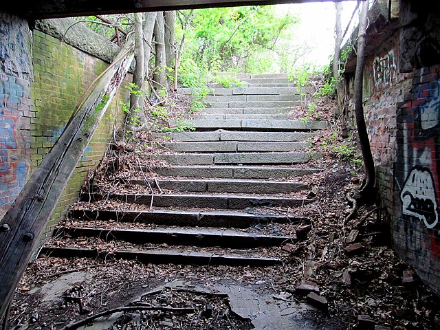
Trolley incline, where bridge path forks off of main path. There's a couple murals dotting it at its highest point.
wk4njr.jpg

The Lower Mills Branch (abandoned 1992) split off the Old Colony main @ the Planet Fitness parking lot right on the Dorchester shoreline, then followed the current path: under MA 3A + I-93, crossing Gallivan Ave. at-grade, slipping under the Mattapan Line in the middle of the cemetery, then running next to the trolleys on the path side of the fence out to Central Ave. Mill was accessed by backing up from end-of-track past Central Ave. over the river bridge. As you can see here, the freight track by the bridge spur was at much lower level than the trolleys, which were raised up between Milton station and Central Ave. onto this mini-incline for reasons unknown.


Looking towards Central Ave. from site of the mural.
1znq2vc.jpg


Up close and personal with an outbound at site of the mural. This is MUCH closer than it looks in the pic...maybe 4 feet.
30j2wqu.jpg


At Central Ave. The A/C was blasting on the trolleys today. Car 3087 I noticed is starting to develop some rust spots around the front doors, and another unit (didn't catch number) seen from street level above Milton station had some creeping roof corrosion. Time for a fresh paint job on the fleet???
j6lxz8.jpg
 
Last edited:
so the Neponset path phase II went with this as the final alignment?
Pages-from-Neponset_Trails_Public_8.30.2011v2.png
 
so the Neponset path phase II went with this as the final alignment?
Pages-from-Neponset_Trails_Public_8.30.2011v2.png

No clue what the final-final decision was since I haven't been paying much attention to this debate. They're definitely hauling ass towards Valley Rd. with the grading work: 500 ft. cleared as of today, 1500 ft. to go to reach the VR platforms.
 
That's the alignment, you can see construction progress on Google Satellite now! Both the canopy walk and the new bridge over the river are in, some of the pavement is already laid, and the path should open this fall.
 
Walked the Bruce Freeman through Acton today- no current work paving, but bridge repainting is all done, bar hopefully some cleanup on the oil slicks currently sitting on the water below.
http://imgur.com/a/ADhL5
 
Given that we were just talking about Riverside paths:

http://village14.com/2014/01/30/riverside-path-open-up-34-mile-of-newton-waterfront/#comment-69696

That's a pretty dickish thing for the MBTA to send a citizen. The commenter doesn't include what he sent them, but I assume (from his post) it mentioned that people in Auburndale and Lower Falls have been using that underpass with frequency for my whole life.

The MBTA is a public agency, and the logic here is notably self-serving. If the underpass is structurally sound (and I sure hope it is, given what's on top of it), simply refacing it shouldn't be a massive expense. Similarly, installing fencing along the tracks isn't a huge project. Between the MBTA, DCR, and the City of Newton, someone should be able to pay for that. It can't be close to as big as the nearby pedestrian bridges, for instance.

FWIW, those bridges (and the Lower Falls path) make this position from the MBTA and State Police incompatible with the position of DCR and MassDOT, which have invested in those bridges and maintain recreation facilities on both sides of the tracks that have been severed by the underpass closure.

This is an MBTA asset. It is important to public transportation in the neighborhood. That makes it the MBTA's problem to get it functional. It definitely shouldn't be sending dismissive emails to citizens that ask why it was closed without notice or explanation.
 
That doesn't seem particularly dickish given the actual situation. That underpass has had no trespassing signs for years. It is extremely low - no more than six feet high - so it would have to be undercut to make it anything less than outright dangerous to us tall folks. The roof of the underpass is the rail bridge - your head is about three feet from trains. I've been in that underpass while a train passed, and it was a terrifying experience. The south end is a set of warped stairs, and the access to the park is over a steep, narrow dirt path.

This isn't an issue of the MBTA needing to spend a few bucks on paint and grout and fencing. This is something where the work necessary to make it safe, comfortable, and ADA accessible, including grading a switchbacked path to the ped bridge, would easily cost half a million dollars or more.

There is an existing path that connects the recently renovated Recreation Road Footbridge to Recreation Road, running along the outside of the MWRA fence. It's not clear whether that path (constructed in 2012) is actually publicly open; it wasn't as of 2014. But if it's not, that should far and away be the preferred route rather than a pedestrian tunnel.

I'm also rather suspicious whether this is a route that anyone other than that one commenter uses. From most parts of Auburndale to most of Lower Falls, Grove Street is faster under any circumstance. From Recreation Road to Lower Falls takes you along the primary ramp from 128 to 90, with no sidewalk (though part of the way you can use an abandoned ramp).

The only reason to spend the money to refurbish the underpass for public use would be as part of a comprehensive trail program. That would include the Lower Falls Branch Trail not only going to the Riverside lot but also having a branch snake along the bank of the Charles behind the maintenance facility, with a connector up the hillside to Riverside Center.
 
Here's what the interior of the tunnel looks like, incidentally:

640px-Graffiti_in_pedestrian_tunnel_at_Riverside%2C_May_2012.JPG

640px-Tunnel_under_the_tracks_at_Charles_Street%2C_Newton_MA.jpg

640px-Steps_to_old_Riverside_station_from_tunnel%2C_May_2012.JPG


There really needs to be a comprehensive bike/ped plan for the Auburndale/Riverside/Lower Falls area. There's a lot of opportunity for them to be very bike/ped friendly areas, but right now there's so many missing links. Here's a map I've made. There's a lot of streets with decent sidewalks, but true paths, bikeways, and several critical connections are missing.
 
There really needs to be a comprehensive bike/ped plan for the Auburndale/Riverside/Lower Falls area. There's a lot of opportunity for them to be very bike/ped friendly areas, but right now there's so many missing links. Here's a map I've made. There's a lot of streets with decent sidewalks, but true paths, bikeways, and several critical connections are missing.

There was a comprehensive plan back in the 1970s, but it needs to be updated. As for the underpass itself, are you suggesting that people cross the river on one bridge, then cross back on the other?

No one is going to walk down Recreation Road (except for me when I want to go that way for nostalgia value). My point is that there IS a path along the river there, and there's plenty of people walking their dogs along it. As described earlier on this thread, it runs along the back of the Riverside Yard and currently pops out on to the MassDOT access drive.

In the present, that doesn't do much for you, but the Riverside Development (if it ever happens) is going to have an overlook and set of stairs to access that path from the station. At that point, the underpass and river path become a desirable station access point from the northern section of Auburndale. Woodland/Hancock/Grove is much less direct. Since the path is always going to be paved with dirt (and roots and rocks) and have a grade, I doubt ADA is going to be plausible here, so steps will do fine. No need for a ramp.

This isn't just a path the commenter takes today, and it definitely won't be one that no one uses in the future.
 
Nicole Freedman (former "Bike Czar" of Boston and currently working on Seattle's troubled bikeshare) is returning to the region to be Newton's Transportation Director:

The week ended with much better news, the hiring of Nicole Freedman as the new Transportation Director, a position that has been vacant since the departure of Bill Paille in January. Per DPW Commissioner Jim McGonagle's email to City Councilors yesterday "Nicole comes to us having most recently served as the Chief of Active Transportation and Partnerships for the City of Seattle, WA. Prior positions included Director of Bicycle Programs for the City of Boston and Executive Director for Hub On Wheels." Let's hope Nicole is able to help move Newton forward in creating safer streets for all. Bike Newton is prepared to partner with her to help get it done.

(via Bike Newton)
 

Back
Top