Biking the Boston 'Burbs (Trails, MDC, & Towns beyond Hubway area)

Took a walk along the Reformatory Branch this weekend. The signs are thick advocating rejection of the bike path enhancements, and using a cute cartoon turtle to tug at the heart strings. There is practically a billboard right at the Concord town line.

There are aspects of the project I'd like to see completed and other aspects of the projects that I would not like to see completed.

The most no-brainer improvements proposed are:
  • Extension of the bikeway along Railroad Avenue:
    • A raised shared-use path along the south side of Railroad Avenue that would maintain crossing access for abutting businesses and residents.
    • A new five foot sidewalk on the north side of the road.
    • Repaving with new striping.
    • A new closed drainage system to decrease flooding.
  • New 11-space permeable pavement parking lot where Railroad Avenue and the Reformatory Branch Trail meet:
    • New landscaping features, benches, bicycle racks, signage, etc.
  • Ramp from the path to the end of Evans Avenue for access to the trail.
  • A non-motorized crossing at the end of Turf Meadow Rd for access to and across the trail.
  • Seperate the bikeway from the Water Department's access driveway east of Hartwell Rd:
    • Driveway and path separated by a vegetated buffer with new tree plantings.
  • Improvements to the Hartwell Rd crossing:
    • Accessible crossing with flashing pedestrian signal to warn motorists of users crossing the road is proposed. This would be an improvement and I'm on board with that.
      • Personally, in a perfect world, I'd rather sever the automobile connection and have Hartwell Rd dead-end on either side of the path with a non-motorized crossing connecting across the path.
  • New 15-space permeable pavement parking lot at the end of Lavender Lane:
    • Landscaped to provide screening for the nearby homes.
    • Benches, signange, bicycle racks, etc.
    • Non-motorized crossing connection to the adjoining conservation land trail network.
  • New 15-space permeable pavement parking lot off of Concord Rd:
    • Landscaping, water fountain, picnic table, bicycle racks, signage, etc.
  • Underpass under Concord Rd:
    • 10 ft tall by 18ft wide underpass.
    • Accessible ramp connection.
    • New sidewalk to Bonnievale Drive.
These aspects of the project improve access to the trail and improve connections to the Minuteman without destroying the existing natural, dirt trail.
 
These aspects of the project improve access to the trail and improve connections to the Minuteman without destroying the existing natural, dirt trail.

Those trying to keep it as a "natural dirt trail" are just trying to restrict access to limit the user count so they can enjoy it for themselves. Selfish NIMBYism at its best.

We need more access for safe, comfortable non-motorized transportation in this state. If you're arguing against that you're on the wrong side of history.

I disagree with that simplistic view. I believe we need more safe, comfortable, non-motorized transportation in this state and I also believe we need to protect natural areas. This project does one at the expense of another.

I strictly bicycle and walk as my only two forms of transportation for context. I am the furthest thing from arguing against safe, comfortable, non-motorized transportation.

The reality is that those non-motorized transportation forms are constantly pitted against one another for a tiny slice of the pie, while car-supremecy continues to reign. Here we have one the few natural, dirt paths in the area that I enjoy very regularly.

The best thing about this project is that it would provide more safe, comfortable, non-motorized transportation infrastructure. The worst thing about it is that it is paving a more natural stretch. One of the reasons I love non-motorized transport is that it provides the opportunity to decrease our species’ footprint on the natural world.

In a perfect world, we (non-motorized users) wouldn’t be fighting each other for scraps, but rather some space could actually be taken from automobiles. Turning automobile space into micro-mobility space is a step in the right direction, but paving a forest isn’t quite as obviously positive.

EDITED TO ADD: I’m in favor of many aspects of this project, as outlined above.
 
Last edited:
The Reformatory Branch article at the Bedford special town meeting failed to get 2/3rds support. The final tally was 537 for and 537 against.
 
^^ That's really too bad. Why did it need a 2/3 majority?
 
Perfecting the title to the bike path might require eminent domain.

I wonder whether the state could step in and do all the work. It’s similar rationale to building a highway, but the intended vehicles are different.
 
Perfecting the title to the bike path might require eminent domain.

It was one of the possibilities, and because of that it needed the 2/3rds majority. (I'm not sure why that's a requirement when eminent domain is involved, but it is.)
 
I'd love to see them come back with a plan that includes only the "no-brainer" changes I outlined above, that improve access while also balancing conservation and preservation. I believe that would have much more widespread support. Quoted here for reference:

  • Extension of the bikeway along Railroad Avenue:
    • A raised shared-use path along the south side of Railroad Avenue that would maintain crossing access for abutting businesses and residents.
    • A new five foot sidewalk on the north side of the road.
    • Repaving with new striping.
    • A new closed drainage system to decrease flooding.
  • New 11-space permeable pavement parking lot where Railroad Avenue and the Reformatory Branch Trail meet:
    • New landscaping features, benches, bicycle racks, signage, etc.
  • Ramp from the path to the end of Evans Avenue for access to the trail.
  • A non-motorized crossing at the end of Turf Meadow Rd for access to and across the trail.
  • Seperate the bikeway from the Water Department's access driveway east of Hartwell Rd:
    • Driveway and path separated by a vegetated buffer with new tree plantings.
  • Improvements to the Hartwell Rd crossing:
    • Accessible crossing with flashing pedestrian signal to warn motorists of users crossing the road is proposed. This would be an improvement and I'm on board with that.
      • Personally, in a perfect world, I'd rather sever the automobile connection and have Hartwell Rd dead-end on either side of the path with a non-motorized crossing connecting across the path.
  • New 15-space permeable pavement parking lot at the end of Lavender Lane:
    • Landscaped to provide screening for the nearby homes.
    • Benches, signange, bicycle racks, etc.
    • Non-motorized crossing connection to the adjoining conservation land trail network.
  • New 15-space permeable pavement parking lot off of Concord Rd:
    • Landscaping, water fountain, picnic table, bicycle racks, signage, etc.
  • Underpass under Concord Rd:
    • 10 ft tall by 18ft wide underpass.
    • Accessible ramp connection.
    • New sidewalk to Bonnievale Drive
 
I know it's apples and oranges, but as a semi-regular rider of that trail on my hybrid bike, I'd much rather see effort put into connecting it to the Freeman trail. A big part of the "fun" of the Reformatory Branch trail is that it's both unpaved and not a technically or physically challenging ride.
 
I know it's apples and oranges, but as a semi-regular rider of that trail on my hybrid bike, I'd much rather see effort put into connecting it to the Freeman trail. A big part of the "fun" of the Reformatory Branch trail is that it's both unpaved and not a technically or physically challenging ride.

100% agreed! I've outlined all of the upgrades above that can be pursued while still leaving the Reformatory Branch unpaved.
 
There are two efforts underway to impact the use of the Central Mass corridor. Protect Sudbury made an attempt to force the STB to determine the status of the corridor as having discontinued service vs. being abandoned so that they could claim that using the corridor for a trail and/or underground utilities would prevent revival for rail service and therefore would be prohibited due to the non-abandoned status. The STB smacked them down hard in November: https://dcms-external.s3.amazonaws.com/DCMS_External_PROD/1643815805751/50926.pdf

Lots of quotes, but here are my faves:
Here, however, PSI has no interest in the integrity of the rail
system or the provision of rail service, which is what § 10501(b) is designed to protect. Because
PSI has no interest in rail service, or even a claimed property interest in the rail line, it is
unnecessary for the Board to determine the extent to which preemption might apply...

The Board also need not address the issue of whether the Line
was abandoned. Apparently, PSI seeks a determination that the Line was not abandoned only
because such a determination is necessary for the Board to reach the preemption question, which
is, in effect, the issue raised by PSI.


A related effort, via corridor abutters, (as best as I can tell) wants the STB to find the property to be abandoned, and therefore not subject to its jurisdiction so they can press the claim in MA land court: https://dcms-external.s3.amazonaws.com/DCMS_External_PROD/1655993838928/304818.pdf

One of the MBTA's replies indicates that they're not amused by this:
In fact, it appears that the Landowners have exhausted every state law option they can conceive of to block this project, which probably explains the present Petition and the one before that advanced by Protect Sudbury, Inc. (The Landowners lack of success in various state proceedings to block the Eversource project is not evidence of “steamrolling,” as they would have it. Rather, it is evidence that the Landowners’ opposition consistently has been without merit.)
 
A related effort, via corridor abutters, (as best as I can tell) wants the STB to find the property to be abandoned, and therefore not subject to its jurisdiction so they can press the claim in MA land court

Denied by STB: https://dcms-external.s3.amazonaws.com/DCMS_External_PROD/1670863978570/51395.pdf
Thus, a Board order is not needed for Landowners to file a state court action seeking to invalidate the MBTA taking and establish a reversionary interest in the right-of-way. Indeed, Landowners apparently agree with this conclusion as they have now filed an action in state court seeking to do exactly that. Given that Landowners admittedly have no current property interest in the right-of-way under state law and that a Board order regarding the status of the Line will have no effect on the parties’ property rights unless the state court invalidates MBTA’s taking, the Board will exercise its discretion not to issue a declaratory order at this time.


Also, an STB version of a smackdown regarding claims of interest in freight service.
Landowners claim that the businesses abutting the Line have expressed interest in rail service...In Exhibit A of the petition, Landowners have provided declarations signed by the owners of these businesses stating, “In the event that freight service is restored at some future time, [name of business], will consider receiving freight service depending upon the cost of service and availability of product.” (Landowners Pet., Ex. A.) Mr. Schineller only describes local changes that could possibly generate an interest in rail service at some point in the future. (Schineller Reply 6-8.) Such generalized (and highly qualified) assertions regarding the potential demand for rail service at some indeterminate time in the future are too indefinite and speculative to provide an adequate basis for the Board to devote resources to determining the status of the Line at this time.
 
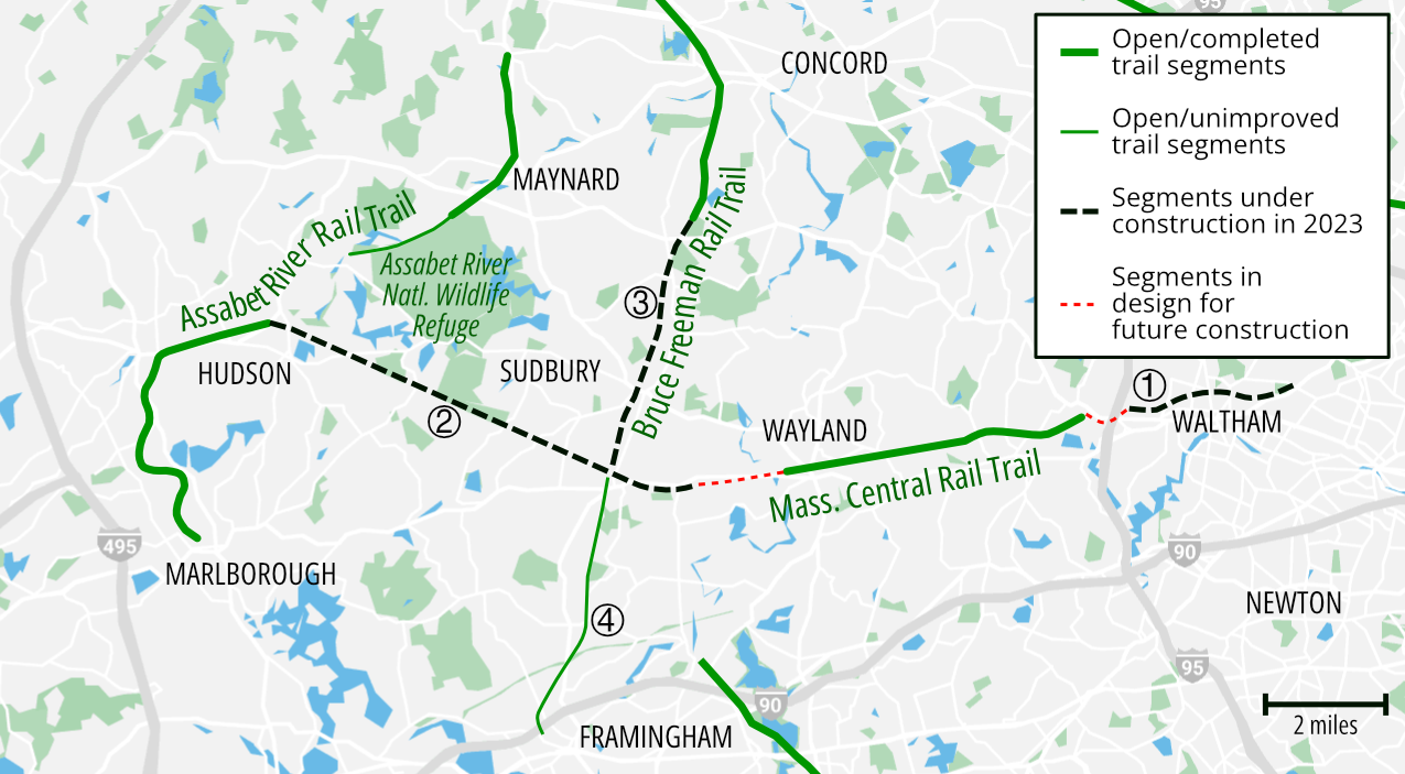
Work has begun on the Bruce Freeman trail for its 5.9 miles in Sudbury (from the Concord town line to South Sudbury near the Sudbury Diamond)

Details on the start of work:

Orientation Map, showing Sudbury's portion in relation to others:
bfrt-map-2008.jpg
 
I believe this Facebook photo is of the Sudbury Diamond (the "hashtag" / octothorpe shaped rail junction in the foreground) at the southern terminus of the Bruce Freeman segment being constructed
328781245_3385821458347389_359855571869140676_n.jpg
 
Last edited:
Yes, but the work being done here is on the MCRT.
 
Is there a plan for what the intersection of the two trails is going to look like? I really hope it's a rotary with the old diamond in its original location in the middle.
 
Is there a plan for what the intersection of the two trails is going to look like? I really hope it's a rotary with the old diamond in its original location in the middle.
From Sheet 16 in the https://sudbury.ma.us/pcd/wp-content/uploads/sites/326/2022/04/BFRT-Conformed-Plan-Set-220901.pdf
North is on the right in this view and at the left we see that it is up to Mass Central to build the rotary you propose at the side of the old diamond (at left),
with the Mass Central running East to West (down to up), and then Station Road at far left.
MCRT-BFRT.jpg

All I could find in the MCRT plans is this (from the landscaping section), but, yes, there it is! Eversource will be building the rotary at the old diamond:
1675725975026.png
 
Last edited:
The Bruce Freeman Trail is one of the few major trails in MA that I have not ever done. Will have to look at it again. One of the issues dissuading me from it in the past was that its one-time southern end in Carlisle had no parking. I have done most of the other MA trails - Cape Cod Canal, Shining Sea, Cape Cod Rail Trail, Blackstone River (Millville/Blackstone and Milbury/Worcester sections). Charles River, Minuteman, Assabet River, Nashua River, Milford Upper Charles, Norwottuck, Manhan, Southwick-Farmington Canal, and Ashuwillticook. I live in North Attleborough right by the RI border so I do the RI trails frequently - Blackstone River, East Bay, Washington Secondary, and O'Neill South County. Other paved New England Trails I have done include Island Rail Trail in VT and Franconia Notch Trail in NH. During the pandemic peak, I biked several non paved/less crowded trails in New England including the Airline and Hop River trails in CT and the Ashuelot River in NH. Many years ago I also did the non paved Delaware & Hudson in western Vermont.
 
Last edited:

Back
Top