Patrick Winn
Active Member
- Joined
- Aug 19, 2020
- Messages
- 256
- Reaction score
- 519
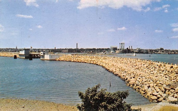
New Bedford's hurricane barrier is a beauty.Providence and New Bedford have both had such harbor barriers for many years.
New Bedford's hurricane barrier is a beauty.Providence and New Bedford have both had such harbor barriers for many years.
Yeah, it looks greatNew Bedford's hurricane barrier is a beauty.

I've spent a lot of time in New Bedford and I think it's a beautiful city in general, but the hurricane barrier gives it a really unique vibe. It was a massive project and there are walkways along the top of it near downtown. Not the most flattering photo you posted there. Here's one that gives you a sense of the scope.Yeah, it looks great

Yeah, it looks great

I've spent a lot of time in New Bedford and I think it's a beautiful city in general, but the hurricane barrier gives it a really unique vibe. It was a massive project and there are walkways along the top of it near downtown. Not the most flattering photo you posted there. Here's one that gives you a sense of the scope.
I lived there for 4 years and loved it. Not only New Bedford itself, but the surrounding countryside, beaches, and towns are great. And it's near Cape Cod.Absolutely. The walkway is great (also great place if you've got a dog/dogs), plus you can access Palmer's Island and the lighthouse. It's a cool city with tons of excellent (and, for now, affordable) architecture that's poised for big things. Don't be surprised if/when New Bedford becomes what Portland, Maine became in the mid-'90s. Unless something disastrous on a national/global level takes place (unfortunately all too possible...) this place will become a new hepster hot-spot.
So, armchair engineers, open up your drawing apps and show me where you would want this very necessary infrastructure piece to go.
Keep in mind that a straight line is not necessarily the right answer.
Are you reading my diary? Honestly, without raising the parkways and putting an overflow barrier on the Saugus River as well, everything else will flood by way of the Belle Isle Marsh to Chelsea Creek. No point to a Blue Line extension if it’s underwater. If it’s less than 3 feet above sea level, it’s going to spend 1/3 of the year flooded - including all planned or present development.The deepest water along this route is ~65 ft, between Deer Island Light and Long Island, but you'll encounter 40+ ft depth no matter where you build it (the inner harbor is 40 ft even between the North End and East Boston), and this protects much more than an inner harbor barrier would.
- Malden -> Revere, under parts of Route 1 (by Rumney Marsh).
- Revere St (Revere) -> Oak Island, by raising the Newburyport/Rockport Line tracks
- Oak Island -> Beachmont, raising Oak Island St and Revere Beach
- Beachmont -> Winthrop Highlands, by raising Winthrop Parkway
- Winthrop Beach -> Cottage Hill, by raising parts of Winthrop Shore Drive
- Cottage Hill -> Fort Dawes, raising parts of Yirrell Beach and Port Shirley Beach
- Deer Island -> Long Island, via Deer Island Light
- Long Island -> Moon Island, by raising and connecting parts of Moon Island Rd and Long Island Rd
- Squantum -> North Quincy, raising parts of East Squantum Street, and Huskins Ave
About a half-mile of 30+ ft depth, all between Deer Island Light and Long Island.
The rest of the route is either shallow water or land. It protects from storm surges, all of Boston, the Neponset River Valley (North Quincy, Milton), the Charles River Valley (Cambridge, Brookline, Watertown, Newton), the Mystic River Valley (Charlestown, Chelsea, Everett, Malden, Medford, Somerville, Arlington, Winchester), as well as Winthrop and most of Revere.
Are you reading my diary? Honestly, without raising the parkways and putting an overflow barrier on the Saugus River as well, everything else will flood by way of the Belle Isle Marsh to Chelsea Creek. No point to a Blue Line extension if it’s underwater. If it’s less than 3 feet above sea level, it’s going to spend 1/3 of the year flooded - including all planned or present development.
This strikes me as very similar to the argument that some birds are killed by windmills. Yes, some are. But such arguments ignore two key things: 1) there are viable mitigation strategies; 2) failing to adapt to climate change will be far more harmful than these chicken little concerns.
Yes, everything in life is a trade-off. To get something, you have to give up something. There will be environmental impacts no matter what we do in a modern society.This strikes me as very similar to the argument that some birds are killed by windmills. Yes, some are. But such arguments ignore two key things: 1) there are viable mitigation strategies; 2) failing to adapt to climate change will be far more harmful than these chicken little concerns.
Nantasket Roads: There's always a way, but I think I'd yield to a cost/benefit study on that portion.Do we need a second access point, on Nantasket Roads, for example?
Is there a logical way, benefit to moving tanker and particularly LNG, docking facilities out of Chelsea Creek, to outside the harbor barrier? (Deep water docking port.)
