You are using an out of date browser. It may not display this or other websites correctly.
You should upgrade or use an alternative browser.
You should upgrade or use an alternative browser.
Bulfinch Triangle Infill & Small Projects
- Thread starter KentXie
- Start date

Ron Newman
Senior Member
- Joined
- May 30, 2006
- Messages
- 8,395
- Reaction score
- 13
I'm glad the two-story will stay and get some love. Which parcel will have the supermarket?
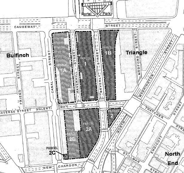
The three proposals are the ones chosen by the MTA (in most cases they were the only proposal so it wasn't a difficult choice). They're all listed as Under Review in the BRA website. When they'll get built probably depends on when the BRA approves them and what the market demand is. Given its current state the development may end up as office rather than residential. The supermarket is in this proposal (Parcel 2ABC) and both the North and West End commmunities want it so Menino will try to influence the developer to get it built sooner rather than later. I think the waterfall is a vertical map of the former Middlesex Canal, from which Canal St. gets its name.
shiz02130
Active Member
- Joined
- May 25, 2006
- Messages
- 140
- Reaction score
- 0
Could someone post an overhead photograph (from Google, maybe) with lines designating exactly where all these parcels are? I know the basic outline, but I'm not sure I understand exactly how this huge area was broken up into sub-parcels.
JimboJones
Active Member
- Joined
- Apr 4, 2007
- Messages
- 935
- Reaction score
- 1
Wishful thinking
Ha. In this design above, what's the high-rise in the back?
Wishful thinking on the part of the BRA?
Ha. In this design above, what's the high-rise in the back?
Wishful thinking on the part of the BRA?
- Joined
- May 25, 2006
- Messages
- 7,034
- Reaction score
- 1,874
Wow, that is actually pretty nice.
Also, there already was a thread for the Bulfinch Triangle area so I combined all these proposals into that just to keep things simple.
Also, there already was a thread for the Bulfinch Triangle area so I combined all these proposals into that just to keep things simple.
JimboJones
Active Member
- Joined
- Apr 4, 2007
- Messages
- 935
- Reaction score
- 1
Stumped
I can't figure this all out.
Here's my best guess.

The problem is, a lot of these roads don't exist on Google Maps, and/or Google Maps still show the Central Artery.
The BRA mentions Beverly St and Haverhill St, which both exist to a large part under the greenway, I think. Traverse St doesn't show up, at all.
One thing - Avenir Boston is supposed to be built on Parcel 1A - is this the same as Parcel 1? If so, there should only be two rectangles at the top, not three.
Is anything being built on-top-of the artery, or just to the side?
I can't figure this all out.
Here's my best guess.
The problem is, a lot of these roads don't exist on Google Maps, and/or Google Maps still show the Central Artery.
The BRA mentions Beverly St and Haverhill St, which both exist to a large part under the greenway, I think. Traverse St doesn't show up, at all.
One thing - Avenir Boston is supposed to be built on Parcel 1A - is this the same as Parcel 1? If so, there should only be two rectangles at the top, not three.
Is anything being built on-top-of the artery, or just to the side?
JimboJones
Active Member
- Joined
- Apr 4, 2007
- Messages
- 935
- Reaction score
- 1
Fun with maps
Okay, anyone have more knowledge of this?

I can't figure out what's where.
Okay, anyone have more knowledge of this?
I can't figure out what's where.
Ron Newman
Senior Member
- Joined
- May 30, 2006
- Messages
- 8,395
- Reaction score
- 13
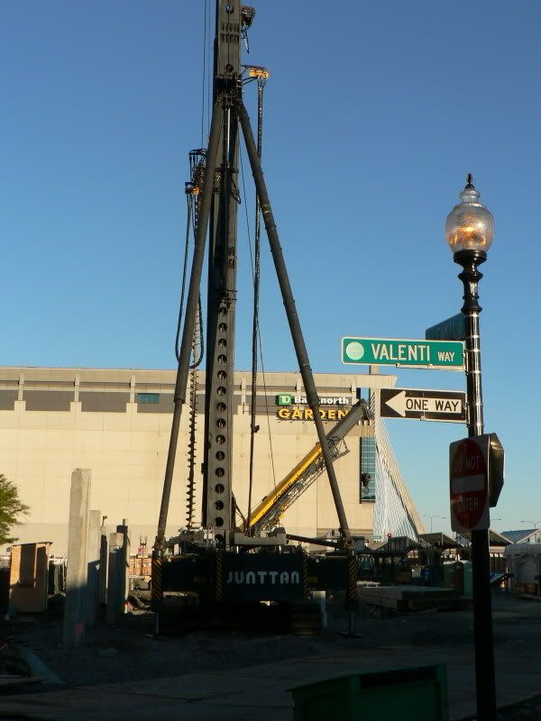
Traverse Street is now called Valenti Way.
KentXie
Senior Member
- Joined
- May 25, 2006
- Messages
- 4,195
- Reaction score
- 766
Re: Wishful thinking
That is the "probably never will be built" North Station Towers.JimboJones said:Ha. In this design above, what's the high-rise in the back?
Wishful thinking on the part of the BRA?
BostonObserver
Active Member
- Joined
- Dec 26, 2006
- Messages
- 573
- Reaction score
- 103
Re: Wishful thinking
There is too much money to be made here for the buildings not to be built. Same with North Point.
Did they always plan to save the low rise building?
DarkFenX said:[That is the "probably never will be built" North Station Towers.
There is too much money to be made here for the buildings not to be built. Same with North Point.
Did they always plan to save the low rise building?
KentXie
Senior Member
- Joined
- May 25, 2006
- Messages
- 4,195
- Reaction score
- 766
Re: Wishful thinking
The North Station Towers are not part of the Bullfinch project. It's entirely different. These towers has been a vision way before the central artery came down and there are nobody taking up the proposal.BostonObserver said:DarkFenX said:[That is the "probably never will be built" North Station Towers.
There is too much money to be made here for the buildings not to be built. Same with North Point.
Did they always plan to save the low rise building?
- Joined
- May 25, 2006
- Messages
- 7,034
- Reaction score
- 1,874
Because all these projects were already in this thread and since they are all right next to each other I don't see the need for an individual thread for each.
I'm missing something. Apart from a passing reference to parcel 1B most of this thread is about Avenir, for which I also created this project-specific thread that wasn't merged into this one. I don't really care whether it's one or multiple threads, but if a single thread is going to be the approach then to be consistent the Avenir thread should be moved here as well.
stellarfun
Senior Member
- Joined
- Dec 28, 2006
- Messages
- 5,711
- Reaction score
- 1,544
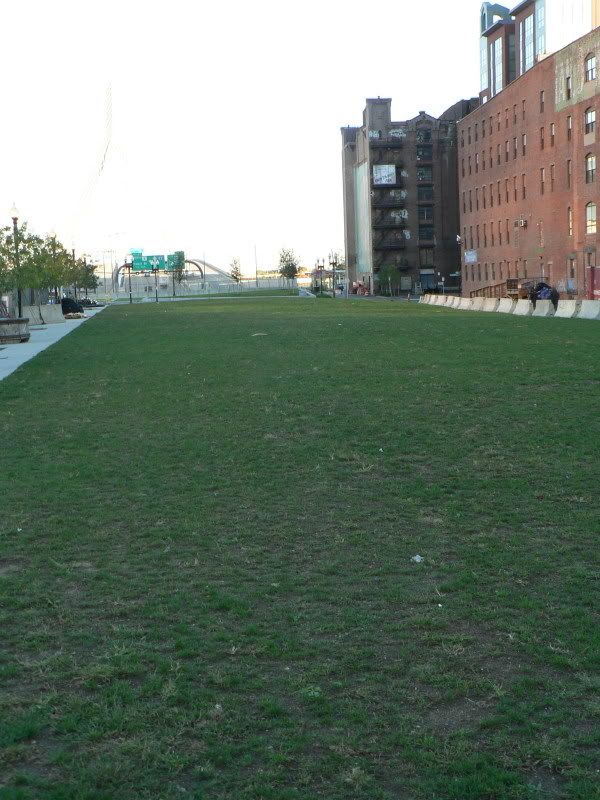
The following pictures were taken Oct 14:
Parcel 1B, looking toward the Zakim.
Avenir and Valenti Way.
Looking south from Valenti Way. The 2A parcel?
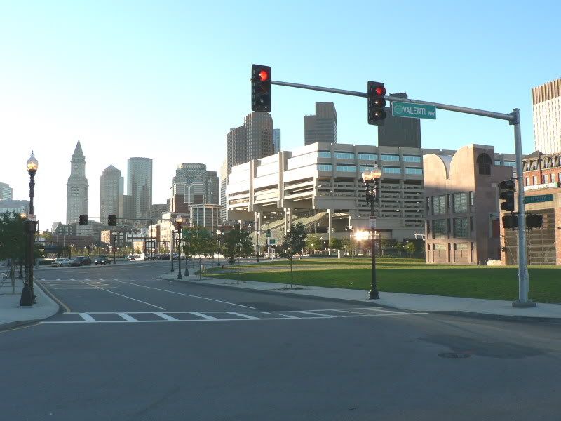
Parcel 1B, looking toward the Zakim.
Avenir and Valenti Way.
Looking south from Valenti Way. The 2A parcel?