Charles River Esplanade Given Landmark Status

briv

Senior Member
Joined
May 25, 2006
Messages
2,083
Reaction score
3
The BLC recently awarded the Esplanade Landmark status. This new designation has prompted a new discussion as to what the park's future will be, and what role Storrow Drive will play in that future.

From WBUR:
WBUR said:
The Parkway Known As Storrow Drive

esplanade_wbur.jpg


By DAVID BOERI

BOSTON ? Like fly paper that comes with its own buzzing, Storrow Drive sticks to the Esplanade. The Esplanade came first. But like Canada geese that multiply and never go away, Storrow Drive crowds the Esplanade?s present, just as it limits its future.

And when the highway needs big repairs, the park it?s stuck to seems fated to surgery as well.

Now comes a big idea for something completely different: ?We should not entertain for a minute building a ?quote? temporary road through the Esplanade to rebuild this mistake,? says MIT professor and former Secretary of Transportation Fred Salvucci.

Taking Storrow Drive down ?certainly should be considered, in a very serious way,? Salvucci says.

Downsizing Storrow Drive would be just fine with Linda Cox, a resident of Beacon Hill and an ardent advocate for the Esplanade. ?First thing you need to know about James Storrow is, he had nothing to do with Storrow Drive,? she says. ?And he would have hated it.?

As workers take down light towers at the Hatch Shell, Cox launches us on an admiring tour of the three-mile long river park where a half million people had gathered a few days earlier.

?The fourth of July concert has been going on since 1929 when Arthur Fieldler founded the Esplanade Pops concerts,? Cox tells me. ?The Esplanade has been here for over a hundred years, but this spectacular really brought it to worldwide attention.?

When TV cameras joined the cannons, the fireworks and the Pops playing the 1812 overture in the 1970s, Boston and the Esplanade became synonymous with the Fourth of July.

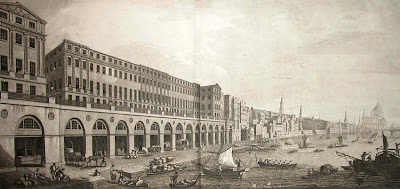
The true grandeur of the park, built atop dredgings from the riverbottom, flowed from the landscaping genius of architect Arthur Shurcliffe, ?who is probably the most important landscape architect you never heard of,? in Cox?s esimation.

Shurcliffe loved Venice, boats and water. He wanted to make the park as much like Venice as possible. So after he was commissioned in the 1930s, he designed semi-circular islands, lagoons and three great granite neoclassical landings that stepped into the river.

Cox stops us on the western end of the Storrow Lagoon. ?As you look east, you can see the lovely symmetry of the lagoon,? she says. ?Imagine no cars. Just grass and trees.?

The view is stunning. It would resemble the reflecting pool in Washington, if the reflecting pool got sideswiped by a highway. ?It would have been even grander,? Cox says. ?You could walk over from the Back Bay.?

It was the most beautiful river park in the world, says Linda Cox, until in 1949, the State Legislature narrowly decided to build a high-speed highway through the Esplanade, to alleviate what supporters called ?disgraceful? traffic conditions.

Not a pretty story

Bitter defeat was compounded when the road was named after James Storrow, the Brahmin champion of the park, whose widow donated much of the money to build the Esplanade, with the stipulation there be no road. ?It?s not a pretty story,? Cox says.

The car was king, and former Secretary of Transportation Fred Salvucci says the power of road building corrupted the Metropolitan District Commission, MDC, a forerunner of the Department of Conservation and Recreation.

?There was a lot of power in becoming, effectively, the metropolitan road system,? Salvucci says. ?The MDC basically destroyed a good part of its own park system. Rather than being stewards of the park, they ended up being a road agency in all too many cases.?

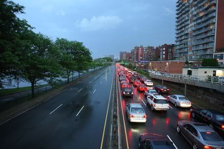
Today, the ?parkway? known as Storrow Drive has a daily crowd of 131,000 cars. It?s almost 60 years old, and its tunnel badly needs replacement. Road managers have just completed the first phase of interim repairs and are about to begin a second phase to buy time while planning the major work ? and how they will handle traffic.

Commissioner of Conservation and Recreation Rick Sullivan had been on the job for only a few weeks in 2007 when he revived an unpopular plan from the Romney years to expedite reconstruction of the tunnel by building a temporary bypass road through part of the Esplanade.

Linda Cox was part of the outraged reaction. ?You know I threatened to chain myself to a tree,? she says.

Commissioner Sullivan says he has the scars to show what he?s learned from the public in 2007, and don?t count on him to be back with that idea. ?I?m not prepared to take anything absolutely off the table,? he says, ?but we heard everybody loud and clear the last time, so I think you?ll see a very different process, I think you?ll see a very different plan.?

Managing a parkway, that?s also a highway

In recent weeks, the mayor and the Boston City Council have approved landmark status for the Esplanade. It would give the park an added measure of protection from schemes like the bypass road.

But Commissioner Sullivan has opposed that designation. ?I don?t believe that there needed to be landmark status for the Esplanade,? he says. ?It?s already constitutionally protected.?

Herein lies the continuing contradiction of being commissioner of the Department of Conservation and Recreation: Rick Sullivan has one responsibility to protect the park, but another responsibility to manage a parkway that has become a highway for 131,000 cars a day.

Here?s Fred Salvucci?s solution: ?The way to solve the problem is to relieve him of the conflict of trying to be both the park commissioner and the transportation commissioner.?

Salvucci says so much has changed since the mistake of building Storrow Drive 60 years ago that it would be an even bigger mistake to mindlessly continue on that road now that there are so many other ways of getting into the city.

?You have the Turnpike; you have the Big Dig central artery, expanded capacity; you?ve got the Ted Williams Tunnel; you?ve got an MBTA that?s expanded considerably, with the Red Line and the Orange Line,? Salvucci lists off.

I put that question to Commissioner Rick Sullivan: Can he foresee a time when this road disappears?

?Standing here today, I guess I don?t see that it disappears,? he answers. ?I mean it really has become an important part of the transportation system in Boston and Cambridge. In fact, it?s even part of the evacuation route.?
But, Sullivan adds, ?who knows what the future holds.?

The Esplanade itself and the great granite landings have fallen into disrepair and need at least $10 million in work that isn?t being funded. The commissioner says he hopes the public process involving the future of Storrow Drive will begin within the year ? after his engineers turn from their focus on repairing bridges.

LISTEN TO WBUR's REPORT HERE
 
No digging necessary. The goal should be to reduce the need for cars to even be driving through the parkland. A lot of excellent points were made during the radio show:

* Long term goal could be to remove Storrow altogether
* In the short term, we can pare it down (i.e. 2 slower moving lanes instead of 4 fast ones), make it a true at-grade boulevard; close it to traffic on Sundays when traffic volumes are light
* To reduce traffic demand on Storrow, we need to: improve transit, improve access to the Back Bay from the Turnpike in both directions, make it cheaper to use the Turnpike instead of Storrow (as opposed to now when it's cheaper to use Storrow)

Big changes don't always have to happen overnight, but with a goal in mind, we can work towards a riverfront that is quieter, cleaner, and healthier by weening ourselves off of Storrow as a major car commuting route.
 
Setting aside the toll issue, to what extent is it physically or politically possible to have the Pike Extension sub in for local Storrow Drive traffic? (If I am going over to Allston or Cambridge I trade off, depending on time of day or my mood.)
 
Storrow Drive needs to be submerged, widened and modernized. All that dead garage and alley space that faces the Esplanade is prime real estate ready for a big idea. It's so funny that what could be the City's most expensive real estate is a hodge-podge of garages, parking spaces and rear-facing building butts. In my mind I see grand, luxury housing directly facing the Esplanade and Charles River, with Storrow Drive buried somewhere within/beneath it.

Killing off Storrow Drive just means Beacon St., Comm Ave and Charles Street become clogged traffic-ridden arteries. You are talking about a major re-alignment of traffic patterns that will greatly impact Cambridge, all of Boston and into Watertown and Newton.

(Isn't Salvucci the genius that bankrupted our state for literally decades to come with his Big Dig scheme - specifically the 75%-dead-space requirement? Good to see he's relegated to the halls of academia where he can't do any more damage)
 
The day they start doing those takings is the beginning of the 3 year period in which I will make 30 to 70 million in legal fees! Bring it on!
 
Why is it that no one seems to be able to spell Arthur Asahel Shurtleff's name correctly?

It's was bad enough he got himself edited out of any credit, and infamously the final architects' portrait, for Colonial Williamsburg. Nowdays no one can even spell the poor bub's name correctly or credit him properly for work he did with Olmsted Jr's office.

Edit:
He anglicized his name in order to work for the Rockefeller family. Shurtleff was still viewed as a second class citizen, despite all the work he did locally, and was a big part of the architectural establishment in Boston at the time snubbing him.

The big push at Harvard and MIT in the 1930s-40s towards Modernism against the Beaux Arts, was in part a revolt towards an entrenched club of anglophiles.
 
Last edited:
Why is it that no one seems to be able to spell Arthur Asahel Shurtleff's name correctly?

It's was bad enough he got himself edited out of any credit, and infamously the final architects' portrait, for Colonial Williamsburg. Nowdays no one can even spell the poor bub's name correctly or credit him properly for work he did with Olmstead Jr's office.


Didn't he himself change his name to Shurcliff, favoring the more anglicized spelling?

And why is no one able to spell Olmsted's name correctly?
 
The problem with burying Storrow Drive is paying for it. At a time when we're trying to reduce our dependence on the automobile, does it really make sense to spend billions to bury one road? Traffic is not like water in the sense that closing a road results in 100% of the traffic going onto other rodes. People shift modes, times of travel, and may simply opt to not take those trips at all. We have a very robust street network which will absorb the traffic that does remain if Storrow were to be shut down. If we reduce Storrow's capacity and availability over time, this transition can be a graceful one, giving people time to re-route and re-plan their own trips and giving us time to make the alternatives more appealing.
 
I don't think it makes any sense to bury it - what is the compelling reason?

Yes, let's close it down. But, instead of making the few people happy who live on Beacon St waterside, let's add another row of townhouses instead.

That will screw with them!
 
I agree with John. When the Back Bay was constructed, the Esplanade was a fetid marsh, so the buildings that lined its edge were built with their backs to it. If the highway is ever removed, as I think it should be, there should be another layer of row houses built fronting the Esplanade, creating the dignified context it deserves.
 
If I could upload a picture of the demolished Adelphi Terrace in London you would see one way of doing it!
 
Proposal for maintaining vehicular use of Storrow Drive as a major thoroughfare while improving pedestrian access to the river:

1. Reconfigure the Soldiers Field Road/Western Ave/River Street/Cambridge Street/Pike exit mess to allow direct flow from inbound SFR onto the inbound pike, and similarly outbound to outbound. My feeling is that many drivers from Newton, Cambridge, Watertown, Arlington and beyond COULD switch to/off the pike here and would be willing to do so, except that waiting at the long intersections involved in switching make it not worthwhile. Storrow ends up the path of least resistance. (This was me while I lived in Cambridge.)

2. Maintain the currently existing exits and on-ramps as the only points of exit and entry for vehicles.

3. SFR/Storrow receives at-grade signalized pedestrian crossings after the BU Bridge (i.e. when the train and the pike no longer separate it from civilization). Crossings exist at the end of cross-streets, which are dead-ended to cars (as most of them are, currently). Including from west to east:

University Road
Granby Street
Deerfield Street
(Somewhere under the Charlesgate spaghetti?)
Every Back Bay cross street from Hereford to Berkeley
Mt Vernon Steet
Pinckney Street
Revere Street

4. Signals are synched and timed, and customized for times of day - maybe 7 minutes green, 1 minute red during rush hour, down to 3 minutes green in mid-day.

5. Pedestrian overpasses remain, to fill in some important gaps in the above list.
 
Thanks, Stat!

This complex was an Adam design (I think) that sat on the Thames until the 1930's. I guess I had the idea you would put the road behind the arcaded area clearly shown in the first and third renderings. But it is too complex for me to puzzle out!
 
Right you are.

Anyway, if you did a limited elimination, from the vicinity of the Cambridge St exit out to the Kenmore Square exit, could you lean on the Pike Extension to pick up the slack?
 
The main problem I see with this is the near-impossibility of adding any eastbound entrances or exits, due to the railroad directly adjoining the Pike.
 
I hadn't considered that. I was fixated on the difficulty of the difference in elevation, and trying to figure out if westbound the Newbury St extension had any role to play.
 
A limited elimination from Cambridge St to Kenmore doesn't make much sense, because the elevated pike and rail tracks continue until the BU bridge. If anything, then, elimination - as I proposed above, signalized pedestrian crossings at the ends of dead-ended cross-streets - should start at the BU bridge.

In any case, I also mentioned above that if we reworked the Cambridge/Allston pike exit to allow inbound SFR traffic to route directly (without lighted intersections) onto the inbound pike, and similarly outbound pike traffic to route directly onto outbound SFR, then we would increase pike utilization significantly. I don't see how this needs to take railroad land as these ramps are primarily elevated.
 

Back
Top