Crazy Highway Pitches

New tube from the gas tank to Logan. 2 full travel lanes in each direction, full breakdown shoulders on both sides in each direction.
Eliminate the Sumner and Callahan tunnels. Push all of the traffic onto the TWT. TWT gets widened to allow for full shoulders on each side, in both directions.
Eliminate the exits on the greenway
Highspeed rail to Logan - starts at Westwood/128 and follows 95/93 to the new tube by the gas tanks. Stops at the exiting Logan Express Braintree lot (eliminate the buses)
The Pike in South Boston is completely decked over
Reconfigure the roads around the exits in South Boston so it flows a bit better
 
Over in the BU master plan thread there was brief discussion of a deck over Storrow near the bridge. I like this idea so thought I'd drop it here for others to chime in
 
Over in the BU master plan thread there was brief discussion of a deck over Storrow near the bridge. I like this idea so thought I'd drop it here for others to chime in
HenryAlan had brought up the concern about taking of esplanade land to deck over Storrow Drive. I think in the stretch from BU Bridge on the west to the beginning of Back Street on the east there is enough room on the south side of Storrow Drive to shift the road south about 4 feet, or more. That would create room on the north side of Storrow for the piers needed to support the deck without infringing on the Esplanade land.

Another concern was that the decking would encourage preservation of Storrow Drive rather than eliminating it outright. I'm thinking that even with the decking, the space under it could be repurposed in the future for an Esplanade light rail line, or even a Blue Line extension, tying into Kenmore Sq and the proposed West Station, then extending west to Watertown or Harvard Sq. And there would be enough width under the deck (where Storrow Drive was) to accommodate a transit station at BU.
 
The stretch of Storrow/SFR behind BU is the most flood-prone portion of the entire parkway. I don't know how you're going to deck it over without massive floodproofing costs on the semi-enclosed roadway level. Plus the Esplanade is nearly flat with the Charles shoreline there the closer you get to BU Sailing Pavilion. It would be an awkward-as-hell spatial interface with the second story, particularly on the narrowest portions. If you're on the bike path, you'll still be sucking carbon emissions from the parkway, now belched from a deep dark hole 10 feet away.

And what kind of streetscape is Back Street going to have with another row of buildings? It's currently all rear parking spaces and dumpsters the full length of BU...typical Back Bay alley faire. It would be one hell of an ugly contrast to erect a new row of front-facing buildings on the other side staring out front-doors at those rat-infested dumpsters.
The deck as I envision it is shown in yellow on the Google aerial photo below, with SFR outlined in red. It would be confined to the main BU campus and end before Back Street. The elevation of SFR would remain as it is now. So, with a deck it wouldn't be any more subject to flooding than it is now,

52473433930_9e90fb99c6_b.jpg
It floods multiple times a year as-is. It's already bad. If you're building new infrastructure here, flood mitigation is going to be ironclad-required. That's going to drive the price skyward.
 
I recently came across this article (from October) about heavy traffic volume at Exit 41 on the Pike in Westfield, and the associated negative impact on the community. A potential solution being discussed is a reconfiguration of the existing Exit 41 trumpet interchange, which seems like a good start.

Although it might be a longshot, a new exit (possibly a diamond interchange) at Montgomery Road in Westfield would distribute traffic between 2 exits instead of relying on a single interchange for all of Westfield. This new interchange would also reduce the length of the large exit gap between Westfield and Lee (admittedly a very minor reduction to the exit gap... only by ~1.5 miles, but I'd argue that's better than nothing).
 
Last edited:
Maybe its time to think regionally and begin another North / South route as well as provide another bridge over the Westfield River to the South. What appears to be a lot of virgin land is already an industrialized strip mining facility (?) and a lot of farm land. It may be a really callous thought to just draw a line thru a green spot on the map but the area is choking regionally. Maybe DOT could grab the perimeter of some these properties and extend down to route 57.
Untitled - Copy.png
 
How much of that is demand for Westfield and not just "Last Exit for 30 Miles", though? I'd think adding ramps at the Blandford service plazas would be an easier and more cost effective way of trying to pull some demand away from there.
 
I'd think adding ramps at the Blandford service plazas would be an easier and more cost effective way of trying to pull some demand away from there.

Blandford residents voted down an exit at the service plaza in 2020, an exit in Otis was also considered but was dropped during planning. An interchange in Blandford is probably off the table for the time being unless local opinion changes in favor of a new exit.

An interchange in Russell with US 20 would be an ideal location to evenly distribute traffic to/from Westfield, but I'm not sure whether Russell locals would be in favor or not.

I agree that an interchange with US-20 in Russell is a better location for a new exit.

I'm happy to see Blandford residents voted down a new exit there. The focus in Blandford, first and foremost, needs to be on conservation and preservation. Does anyone have a resource that shows what land in Blandford is protected from development?

But where would it go? Where I-90 and Rte 20 intersect is pretty much the bridge over the river, and the elevation between the two highways is pretty high. Maybe where Rte 23 crosses the Pike?

Its not directly relevant to that, but for the north-south proposal, the best solution is to finish the connection of 391 back to 91 in Holyoke. It could help ease the issues with the Chicopee Curve.

If I'm embracing the spirit of the thread... To continue the north-south highway improvement around the area: run either 91 or 291 across the river near where 291 and 91 merge, and down rte 5, where its already basically a controlled access highway. Cross back where rte 5 crosses the river. Go diagonal across the river in both cases, so that you don't end up with two new curves just as bad as the Chicopee curve. If re-routing 91, then great, turn the Springfield waterfront back into a waterfront. If 'just' extending 291, then go whole hog, and run 91 underground. Make MGM pay for their section of waterfront they'll have access to.
 
But where would it go? Where I-90 and Rte 20 intersect is pretty much the bridge over the river, and the elevation between the two highways is pretty high. Maybe where Rte 23 crosses the Pike?

Great idea. The interchange would make sense at MA-23, rather than the Westfield River gorge.
 
The focus in Blandford, first and foremost, needs to be on conservation and preservation. Does anyone have a resource that shows what land in Blandford is protected from development?
Go to the Mass GIS map here, pan in on Blandford, and on the options menu on the right, dropdown the Conservation/Recreation line item and choose "Openspace Article 97", and all parcels that are protected by Article 97 of the Massachusetts Constitution (the Constitutional amendment that protects open space, recreational, conservation, and parkland basically into perpetuity) will appear as light green with black spots. It looks like Blandford has a lot of Article 97 land.
 
Go to the Mass GIS map here, pan in on Blandford, and on the options menu on the right, dropdown the Conservation/Recreation line item and choose "Openspace Article 97", and all parcels that are protected by Article 97 of the Massachusetts Constitution (the Constitutional amendment that protects open space, recreational, conservation, and parkland basically into perpetuity) will appear as light green with black spots. It looks like Blandford has a lot of Article 97 land.

Thanks. It's a good start. I'd like to see more, and certainly not less, protected land out that way.
 
Great idea. The interchange would make sense at MA-23, rather than the Westfield River gorge.

I'm a few months late posting this, but better late than never. These were the preliminary concepts for an interchange at MA 23 in Russell. This image is from the I-90 Interchange Study Final Report, page 4-10.

MA 23 Interchange.PNG

This potential interchange was dropped from consideration in the recent study because an interchange in the center of the "exit gap" was desired, i.e. in Becket, Otis, or Blandford. Being only 6.3 miles away from Exit 41 in Westfield, the MA 23 interchange was seen as too close to sufficiently address the large gap between exits.

I'm pretty doubtful that a new interchange between Westfield and Lee will come to fruition, at least in the foreseeable future. Residents of the towns usually being considered for an exit (especially residents in Becket) have been opposed to the idea since at least the 1980's and possibly even earlier. I don't know whether residents in Russell are for or against an interchange in their town; I haven't been able to find any info online detailing the community sentiment regarding the idea (unlike Becket, which had decades-old newspaper articles detailing the opposition to the idea). Either way, MassDOT doesn't seem very interested in pursuing an interchange in Russell, as it was removed from consideration at their behest, not due to community opposition.
 
I recently came across this article (from October) about heavy traffic volume at Exit 41 on the Pike in Westfield, and the associated negative impact on the community. A potential solution being discussed is a reconfiguration of the existing Exit 41 trumpet interchange, which seems like a good start.

Although it might be a longshot, a new exit (possibly a diamond interchange) at Montgomery Road in Westfield would distribute traffic between 2 exits instead of relying on a single interchange for all of Westfield. This new interchange would also reduce the length of the large exit gap between Westfield and Lee (admittedly a very minor reduction to the exit gap... only by ~1.5 miles, but I'd argue that's better than nothing).

I finally read the article. Looks like the mayor just wants to get truck traffic from the industrial parks off the main road thru town. Basically a direct ramp system like this. There are like 6 distribution centers right next to the airport. C&S Wholesale grocery, Lowes Dist,, Home Depot Distrib. Railroad Dist., FW Webb (plumbing warehouse, Old Dominion (trucking company). Who is the town planner that didn't see an issue with all the traffic from 6 distribution centers??
Untitled2.png
 
This might be a reasonable pitch - however I see little action behind it and maybe a little eminent domain land claiming.

As a reverse commuter who is constantly plagued by the Mass Pike Newton Corner eastbound exit backup during afternoon rush, I have seen that this is a silly problem that needs to be fixed. Mainly because there is minimal eastbound traffic, but the traffic backing up onto the exit ramp backs up the entire highway.

A proposal I would have would be adding an exit only lane for a certain amount of distance to mitigate this. This may mean taking some land off the hill, maybe rebuilding the bridge before the exit, and maybe clearing some space from a parking lot nearby.

The state knows this is a problem and a design flaw. Can there maybe also be another solution like changing the top of the exit ramp to a light? That doesn't seem helpful. There's a sign before the exit noting to expect stopped traffic, so this seems like something that's gotten worse and had a bandaid over it.
 
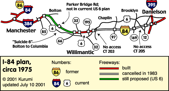
My Pitch: A combined dynamically-tolled road and high-speed rail alignment between Hartford and Providence on the alignment of the original I-84.
Road would be similar to MD-200, in that it would be purely e-tolled and otherwise just 2 lanes in each direction. Could even be HOT (and allow free carpool access to I-84's existing north-of-Hartford HOV lane.

The idea of tolls is both to limit induced demand and noise impact on neighbors, while at the same time paying for both the road and the rail construction. Should charge higher tolls for trucks to price in both wear and tear and again to limit impact on neighbors.

i84e-plan.gif


(road details at: https://www.kurumi.com/roads/ct/harttoprov.html)


And this for the rail:
 

Back
Top