Crazy Highway Pitches

I imagine that restricting lefts on the parts of Comm, Beacon, and Huntington with trolley reservations could speed up the B, C and E lines, respectively.
The challenge with restricting left turns in much of those corridors is the street "grid" (using the term very loosely) does not accommodate a right, right, right alternative for the left turn. It becomes a "you can't get there from here" exercise. Each left turn would have to be examined carefully for rational alternatives.
 
The challenge with restricting left turns in much of those corridors is the street "grid" (using the term very loosely) does not accommodate a right, right, right alternative for the left turn. It becomes a "you can't get there from here" exercise. Each left turn would have to be examined carefully for rational alternatives.
A rough list of intersections I think you could reasonably eliminate:

B Branch:
  • Granby St: If Silber is kept this one is redundant
  • Cummington Mall: Carlton is right there
  • St Marys St: Same as previous
  • Buick St: If Agganis is kept this one is redundant
  • Reedsdale St: Harvard Ave is right there
  • Summit Ave: Washington St is a suitable alternative route
  • Colbourne Rd: Between Wallingford and Washington this one should be covered
  • Strathmore Rd/: Chestnut Hill is right there
  • Chestnut Hill Driveway: Chestnut Hill Ave is right there
  • South St: Greycliff Rd is a suitable place to bang a quick uey
Total eliminated intersections: 24 -> 14 (-41%)
C Branch:
  • Carlton/Hawes St: Pick one
  • Kent/St Paul St: Pick one
  • Charles St: Covered by Harvard and Kent or St Paul
  • Pleasant St: Same as previous
  • Centre St: Covered by Harvard St
  • Winchester St: Same as previous
  • Winthrop Rd: Washington St is right there
  • Dead/Williston Rd: Pick one
  • Englewood Ave: Covered by Strathmore Rd
  • Ayr Rd: Covered by Cleveland Circle (Which should really be a rotary)
Total eliminated: 18 -> 8 (-55%)
E Branch (Just up to Brigham Circle):
  • Evans Way: Covered by Ruggles St
Total eliminated: 5 -> 4 (-20%)
 
Last edited:
This is more of a 'crazy arterial' pitch rather than a crazy highway pitch. Could we just ban left turns along most of Mass Ave? I was thinking about my last visit to Europe and I recalled seeing a lot of intersections where the signals are simple because they don't allow left turns and require you to make "semi direct" (right before, then left, and left) or "indirect" turns (multiple rights) to make the desired left turn. A lot of Mass Ave seems like a place to try this -- they already do a lot of this in Cambridge around Central Square and MIT. In Boston, at least Back Bay and South End seem like places that should be trying this and even between Porter and Arlington in Cambridge.
In commercial or business areas, or even in dense apartment building areas, it would work. However, in residential areas like North Cambridge there would be objections from residents to the increased traffic on their residential side streets.
 
In commercial or business areas, or even in dense apartment building areas, it would work. However, in residential areas like North Cambridge there would be objections from residents to the increased traffic on their residential side streets.
In the case of North Cambridge, or really Mass Ave from Harvard to Arlington center, I'd argue that the bigger obstacle is the fact that streets don't line up across Mass Ave. When they do it's usually not two streets you'd really want to make into a thru way. The exception to this is Cameron - that left off Mass Ave recently got turned into a jughandle via Cedar & Harvey during phase 1 of the Mass Ave bike lane project.
 
Last edited:
In the case of North Cambridge, or really Mass Ave from Harvard to Arlington center, I'd argue that the bigger obstacle is the fact that streets don't line up across Mass Ave. When they do it's usually not two streets you'd really want to make into a thru way. The exception to this is Cameron - that left off Mass Ave recently got turned into a jughandle via Cedar & Harvey during phase 1 of the Mass Ave bike lane project.
The jug handle turn off Mass Ave EB to Cedar/Harvey/Cameron is in a commercial block, so it works politically.
 
I imagine that restricting lefts on the parts of Comm, Beacon, and Huntington with trolley reservations could speed up the B, C and E lines, respectively.
A lot of left turns are already restricted - I'd be interested in finding ways of making more of the existing left turns to become indirect/semi-direct turns instead. Even if they are, as others rightly point out, put a bit more traffic on semi or residential streets.
 
In the case of North Cambridge, or really Mass Ave from Harvard to Arlington center, I'd argue that the bigger obstacle is the fact that streets don't line up across Mass Ave. When they do it's usually not two streets you'd really want to make into a thru way. The exception to this is Cameron - that left off Mass Ave recently got turned into a jughandle via Cedar & Harvey during phase 1 of the Mass Ave bike lane project.
A couple of more wild + crazy pitches would be at the intersections are the most annoying to drive thru and also really awkward when you walk or bike through them because of all the time spent waiting for the left turns on the higher priority through route.
  • Rindge Avenue - Push north-to-west lefts to Haskell, might even be able to make Rindge one-way between Haskell and Mass entering Mass. Also maybe make a longer left turn lane so that cars don't have to fight each other over which lane is really the "through" lane.
  • Cameron - Love the new jughandle for the south-to-east movement and I think they should go all in and make Harvey St a one-way out to Mass
  • Alewife Brook Parkway - no lefts from Mass by reconnecting Foch to Alewife Brook Parkway (right at Gladstone, left at Foch, left at the Parkway, and for the other direction Cameron down south connects up to Holland and Broadway if you're headed to Somerville or rerouting via Marathon, Winter, or Grafton up to Broadway to access the Parkway north, which is what you should've done anyway.
  • Lake St - for the north to west movement, displace the left using Orvis Rd to Brooks
  • Pleasant St - for the north to west movement, use a semi-direct route with Medford Chestnut and Mystic
  • Mystic St - for the south to east movement, and this is the pair with Pleasant - a indirect route with a right on Swan, right on Swan, and a right on Pleasant to cross over to Mystic. removing the left turn pockets and narrowing the lanes you would probably get a lot of width back from the intersection and you might be able to make it much smaller and reduce the length of time at the traffic signals
  • Park Ave in the Heights - people already use Paul Revere road for the south to east movement, the trickery would be to pair the north to west movement with Lowell Rd, but I wouldn't do anything like that unless the town fixes that 6-star intersection into a 4-leg one. but since we're in pretty crazy mode - it would probably just be part of the program.
 
IMG_8070.jpeg

Rush hour today on the Monsignor’s folly. Nobody cares to use this road. It’s as wide as sin. Used to be a trolley reservation if you can believe it or not. It’s time for it to go.
 
View attachment 51984
Rush hour today on the Monsignor’s folly. Nobody cares to use this road. It’s as wide as sin. Used to be a trolley reservation if you can believe it or not. It’s time for it to go.
The Lechmere Sq. re-streetscaping taking the third travel lane for a separated bike lane and widened sidewalk is a really good start, but they really need to extend that much further north to Twin City/Squires Bridge. At least knock out everything within the City of Cambridge so the whole drag is set up to interface with a torn-down McGrath on the Somerville side of the bridge whenever they get around to that. I can't find any MassDOT info about whether the ongoing Squires rehab project is actually going to touch the surface level to do something about trading a lane to widen the beyond-tiny sidewalks. If they were that would be good enough impetus to treat the rest of the East Cambridge blocks now.
 
The Lechmere Sq. re-streetscaping taking the third travel lane for a separated bike lane and widened sidewalk is a really good start, but they really need to extend that much further north to Twin City/Squires Bridge. At least knock out everything within the City of Cambridge so the whole drag is set up to interface with a torn-down McGrath on the Somerville side of the bridge whenever they get around to that. I can't find any MassDOT info about whether the ongoing Squires rehab project is actually going to touch the surface level to do something about trading a lane to widen the beyond-tiny sidewalks. If they were that would be good enough impetus to treat the rest of the East Cambridge blocks now.
This section is now two lanes headed toward the 'vull and two lanes splaying out into a third / right turn pocket headed toward the 'bridge.
 
The Lechmere Sq. re-streetscaping taking the third travel lane for a separated bike lane and widened sidewalk is a really good start, but they really need to extend that much further north to Twin City/Squires Bridge. At least knock out everything within the City of Cambridge so the whole drag is set up to interface with a torn-down McGrath on the Somerville side of the bridge whenever they get around to that. I can't find any MassDOT info about whether the ongoing Squires rehab project is actually going to touch the surface level to do something about trading a lane to widen the beyond-tiny sidewalks. If they were that would be good enough impetus to treat the rest of the East Cambridge blocks now.

As far as I know, the below is the site limits of Squires Bridge. Given that scoping wasn't complete as of February, there's every chance it extends further east from here.
1000034504.jpg

Additionally, I could be wrong, but wasn't the 1/15 McGrath Lab projects (old Sav Mor) supposed to build bike lanes here? Based on the below, it looks like they would have ended just past the Rufo intersection, so I would suggest it's still on the city to build the bits between here and Third St.
1000034505.png
 
As far as I know, the below is the site limits of Squires Bridge. Given that scoping wasn't complete as of February, there's every chance it extends further east from here.
View attachment 51987
Additionally, I could be wrong, but wasn't the 1/15 McGrath Lab projects (old Sav Mor) supposed to build bike lanes here? Based on the below, it looks like they would have ended just past the Rufo intersection, so I would suggest it's still on the city to build the bits between here and Third St.
View attachment 51988
oh! Where did these graphics come from?
 
oh! Where did these graphics come from?
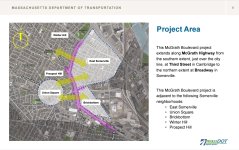
The first is from the McGrath Grounding presentation from February specifically relating to Squires Bridge scope, it was basically a filler slide. The second is from 1 McGrath's 2023 application to the city, it's listed under mobility plans.

That said, as shown that version may be relatively short lived. Keep in mind that MassDOT's McGrath scope is fully Broadway to Third St, so it may get bulldozed as part of MassDOT's unifying vision in ~2030. For now though, the project built ones will be done first.
1000034602.jpg

(MassDOT has been understandably focusing on the viaduct parts, so down around here MassDOT's concept plans are... Not spectacularly useful, especially since it needs to coordinate with the Squires Bridge replacement. They'll probably look better once they're into 25% design though.)
 

Attachments

  • Screenshot_20240629_232002_Adobe Acrobat.jpg
    Screenshot_20240629_232002_Adobe Acrobat.jpg
    429.3 KB · Views: 31
Crazy thought prompted by my crack about MassDOT lacking audacity: With the shift away from petroleum powered vehicles, there is going to be a reduction in gas tax revenue. Instead of raising tax rates or adding additional fees, what about starving the beast? Force MassDOT to think hard about the road network, including decommissioning roads that may be superfluous.
 
Crazy thought prompted by my crack about MassDOT lacking audacity: With the shift away from petroleum powered vehicles, there is going to be a reduction in gas tax revenue. Instead of raising tax rates or adding additional fees, what about starving the beast? Force MassDOT to think hard about the road network, including decommissioning roads that may be superfluous.
To an extent, MassDOT has been; in 2012 they owned 9572 lane miles of roadway in the state. In 2022 they controlled 9279 lane miles. That said, MA added over 800 lane miles of all roadway in that same time period, but almost all of that growth was in what FHWA considers urban local roads - something likely inevitable in any condition, and especially with new development areas building out roadways.
1000034621.jpg


www.fhwa.dot.gov/policyinformation/statistics/2012/hm81.cfm
 
Last edited:
How much, if any, is shifting roads from MassDOT to local control? It doesn’t feel like we have seen lane miles disappearing.
 
How much, if any, is shifting roads from MassDOT to local control? It doesn’t feel like we have seen lane miles disappearing.
I'd go ahead and say basically none; the chart I attached is all lane miles in the state by roadway type, regardless of owner (HM60). I'd pulled the MassDOT mileage using the data from a different chart only showing state agency owned mileage (M81).
 
storrow drive removal idea
demand wont un-induce itself
View attachment 52587View attachment 52588
That concept has been the holy grail of a bunch of us here on archBoston for seemingly decades. A 2015 study was done by MassDOT to add on/off ramps to the Mass Pike at Charlesgate and elsewhere to make it into a viable replacement for Storrow Drive. Here's one ramp addition concept out of that study which I especially like:
1720668110498.png


And this one:
1720668229612.png


Adding these ramps could make the Mass Pike accessible enough to justify eliminating Soldiers Field Road and Storrow Drive from Arlington Street to Allston..
 
Last edited:
290-90 rework.png

I've been driving the pike pretty often and this area where 290 merges into 90w backs up like crazy and then is usually fine pretty close after it goes from 4 lanes back down to 3. I think the major issue is when there is early merging after the cloverleaf section when cars/trucks have not gotten back up to highway speed, it slows everyone down. My solution would be to force some acceleration before merging into the highway is allowed with jersey barriers. Better yet this would be so easy and cheap to accomplish, just some paint and a couple hundred jersey barriers.
 

Back
Top