Here is my question: what is a better investment, the Blue Line along Storrow Dr to take over the Riverside branch or to build out the Huntington Ave subway and divert the D branch through the Huntington Ave subway. What I mean is would the Blue Line extension serve the city better by acting as a bypass around the Back Bay or would an expanded Green Line through the heart of the Back Bay be better? And what would end up being cheaper?
http://goo.gl/maps/ahFml
I think the Green Line would be a better investment and cheaper (with only my understanding of the engineering/politics involved to back me up).
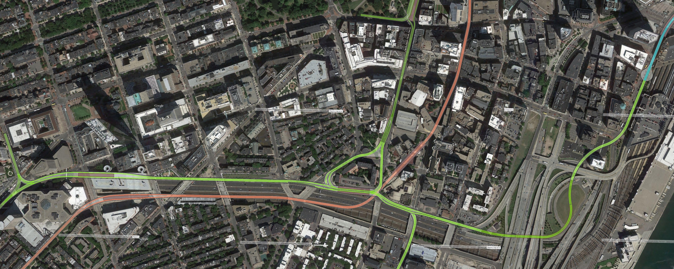
Green would be cheaper if you took the Tremont Street tunnel to Eliot Norton Park, transfer with OL at a Green Line "Tufts Med" (rename it South Cove or Bay Village whydontya) and then go to Back Bay via Marginal and along the Pike retaining wall. That all should be easy tunneling (except for the footings of the Back Bay garage), much easier than under Stuart. Only a short bit of Stuart would need to be tunneled this way to get the line joined up with the current Huntington subway.
I don't know that I would divert all D trains that way. Either add a branch that splits headways to Riverside with one taking the current Fenway route and the other taking Huntington, or add a branch that shares the new tunnel with the E and turns at Brookline Village or Reservoir. Extend this line to Needham whenever that happens.
Using Tremont Tunnel to TMC also allows you to split off there to both South Station/Transitway and a Washington Street surface-line, and have through service between SST and BBY.
Does this plan also eliminate the E Line, because the D Line would cover 95% of the E Line. If so, then a Green Line extension to Needham could be constructed without effecting current Green Line frequencies as the Needham branch would become the new E Line. (Although it would also mean giving up on the ~dream~ of a restored Arborway.)
You wouldn't necessarily have to end Heath Street service if you tunneled under Huntington to Brookline Village, but your options become either a) convoluted, or b) expensive.
First of all we have to consider
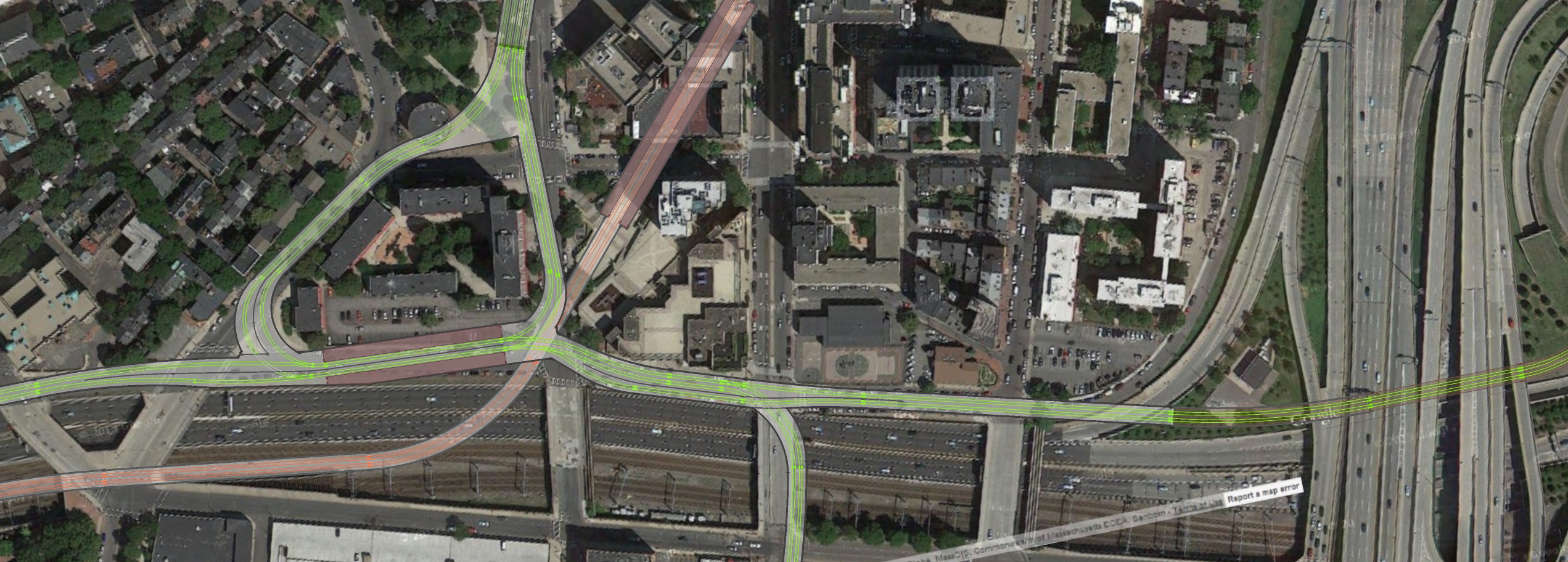
how to link up a buried Huntington Ave subway to the Riverside Line at Brookline Village.
My fantasy map - which, FTR, hasn't been EIS'd or studied for being remotely feasible - assumes that the Riverside Line would need to be depressed in a cut beginning around Aspinwall and coming back to the level ROW around White Place or Cameron Street. Brookline Village station would be in that cut, roughly between Pearl Street and Washington Street. The Huntington Ave subway (at this point Route 9) would need to turn north off of Route 9 to Pearl and junction with the Riverside. An at-grade junction like the Copley Junction would be cheaper. A flying junction would be much more complicated and expensive. (Note that my map also allows for a connection from the west-bound Riverside to Huntington east-bound, which requires a separate junction under Washington Street to rejoin the line. This could also be used to short-turn trains, but significantly adds to costs).
Back to Heath Street:
Option 1 would involve some sort of portal on Pearl and surface running along Pearl, to Route 9 to South Huntington. Basically involving a backtrack to get to Heath Street.
Option 2 would be building a junction under the Huntington/SHuntington intersection. Flying-junction would be better for service, but much harder to fund and engineer. The line would then follow under SHuntington to Heath Street where it could either a) turn around underground, b) portal to the surface and turn around, or c) surface at Heath, keep the short-turn and continue to Forest Hills as a street-car.
A Blue Line extension that takes over the Riverside branch would make a rapid transit expansion to Needham more expensive and more complicated due to the street crossings on the Commuter Rail right of way. This would also make extending the Orange Line out to West Roxbury more difficult as I assume that would never happen until Needham got a replacement for its Commuter Rail service.
Yup. Needham probably won't happen unless it's Green. Too many grade-crossings to deal with.
Orange needs to go to Roslindale Square yesterday, but yeah, it can't get further West to the other Needham Line stops in WRox without being paired with a GLX to Needham.
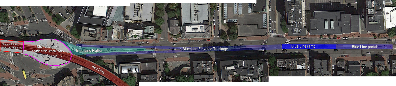
The stations along the Riverbank Blue Line look a lot more useful than the new Stuart Street stations though. Heavy Rail going to Fenway Park is extremely appealing and even though many have complained about the usefulness of a transit station adjacent to the Charles River, the Hatchshell station seems fine and even the second Riverbank station looks better than the two on Stuart Street as they are sandwiched in between the Boylston Subway and Orange Lines.
Kenmore is arguably the
only useful stop on BL riverbank subway, and it is
very useful for Fenway events. An Esplanade station near the Hatch Shell would also be nice for Beacon Hill and Esplanade events, and for tourists. Any intermediate stops in the Back Bay would be fought by wealthy denizens of Beacon Street and beyond, and wouldn't be as close to useful destinations as a parallel Green Line south of Boylston. Green Line at Back Bay station is more useful than Blue Line at Exeter Street on the Charles.
EDIT: This is also setting aside the political battle of downgrading/eliminating Storrow, which is what would be needed to make way for a riverbank BLX. Green adjacent the Pike is way easier politically.
An interesting possibility is continuing the Huntington/Stuart Green Line trolleys to the Seaport District, which would open up the Central Subway to a potential F Line to Dudley Square/Franklin Park. But that may be outside the scope of the question.
Totally. That's how my map does it. It would allow routings from Back Bay and points west to South Station and points east without a transfer.
The Blue Line could also be extended to Kenmore and either terminate there or go somewhere else (Beacon Park/West Station/Barry's Corner/Beyond???) so these two projects are not theoretically at odds.
I terminate BL at Kenmore too. Leaves more options open for potential service to Allston/Watertown/blah, particularly since my map uses the "BU->Kenmore->BV->Brigham" boomerang for the Urban Ring, precluding Riverside's conversion to HRT.