Crazy Transit Pitches

This is partially a proposal and partially an invitation for proposals from the board. These are similar proposals about Malden and Lynn. Both of these cities are becoming more attractive places to live, and both have good bones. I hope, with the assistance of good transit, these cities could become satellite commercial centers. These are places where I have not spent much time, and I am hoping to elicit responses from people familiar with transit and these areas.

Malden:

A city of 59,000 and growing. With a population density of 12,000/sq. mile, Malden is 70% more populous than Chelsea and more than twice as dense as Worcester. The point being that this is a dense, sizable city located within 5 miles of downtown Boston.

Proposal - Build an infill Orange Line stop between Malden Center and Wellington, located at Medford St, called "Edgeworth." This stop will give Malden full-build in terms of transportation to/from Boston, but leave it lacking in local transportation.

Question - How would you improve transit within Malden and the "Malden area?" Assume this is a semi-possible, crazy transit pitch. As in, you have $750 million, 15-years and political will on your side. What would you do?


Lynn:

A city of 90,000 and growing. With a population density of 8400/sq. mile, Lynn is more populous than Somerville and denser than Worcester. The point being that Lynn is also a dense, sizable city located within 10 miles of downtown Boston.

Proposal - Build a DMU line from North Station to the North Shore along the Newburyport/Rockport Line, with stops in Charlestown, Everett, Chelsea, Revere, Lynn, etc. Let's assume the stops in Lynn are "Riverworks" (with TOD), "West Lynn," "Central Square-Lynn Station" and "East Lynn." This will give Lynn full-build in terms of transportation to/from Boston, but leave it lacking in local transportation.

Question - How would you improve transit within Lynn and the "Lynn area?" Assume this is a semi-possible, crazy transit pitch. As in, you have $750 million, 15-years and political will on your side. What would you do?

I dont think Medford St is dense enough to really warrant a T station. However, it wouldn't hurt to add one and it's very close to the new rail trail so could become some sort of multimodal thing. As an aside, I think all of Malden Ctr needs to be redone, since the main roads all have a very 1950s urban renewal feel to them.. and when the time finally comes to redevelop the area along the river (next your "Edgeworth"), I hope they do it right and not more that bland, 128-ish River's Edge soullessness that they did around Wellington.

Transit-wise, the east/west Rt 60 corridor is where the need is for Malden. It would be tempting to take away the bike trail and put in light rail, but I think the real benefit might be connecting Malden Center to Medford Center. Its only a couple miles. Rt 60 in Malden Ctr itself is probably wide enough for LR for a half mile, but it would either require massive eminent domain east of there, or a subway - and it just isn't dense enough to justify either. Just like most of the Boston area - narrow, inadequate roads and medium, but consistent density, enough for horrible traffic but not enough to justify rail transit projects. You could also run a LR from Rt 1 along the bike path, into Malden Ctr and then have it cross the Malden River just below Medford St to run along the unused spur north of Wellington, and then use some eminent domain to run it right into Medford (between Washington and Magoun Ave). But to make it work you'd have to connect it to the GLX by tunneling under College Ave. I still think that would be really cool, though.

I definitely don't think Lynn needs anything more than a direct and rapid connection to Boston. DMU would suffice, I guess, but Blue Line would be ideal. Otherwise, it's a dense city in the core but really it's ringed with a lot of suburbia so I dont think it justifiably needs anything else (like an east west connection to Malden or Saugus).
 
The cities just north of Boston would benefit more from the North-South Rail Link than any rapid transit extension (except Lynn but even then it would suffice). With through running DMU trains and infill stations you'd be able to capture more commuters for the money. A Blue, Orange, or LR system expansion would be a one off thing while DMU commuter rail would be more flexible.
 
Of course, along with building the North/South Rail Link, we'd have to somehow conquer the barbaric railroad unions that will revolt at the idea of running modern, 21st century style service. With useful frequency and efficiency. Heck, they revolted at the idea of running 20th century style service.

I don't know which is harder: digging the tunnel, or dragging those idiots into the 21st century.

Can you elaborate? I honestly do not know what you are talking about. Haha.
 
Well, your typical MBTA Commuter Rail train has 3-4 employees on board. Punching tickets, yapping on the radio, dealing with the fact that we have both high and low platforms in the system, and just being massively redundant in general.

The Commuter Rail typically serves stations 3 times during rush hour (at least, according to Service Delivery Policy) and then infrequently off-peak (sometimes only once every 2 hours).

This is a far cry from 'frequent service' that you might expect on a rapid transit line, where at a minimum you expect trains every 10 minutes or so during the day. And much more frequently during peak.

MBTA Commuter Rail runs according to old-timey style FRA rules, so there is an engineer, plus one conductor for every 2 passenger cars. Whereas rapid transit these days tends to run with a single employee, as the conductor position has been largely eliminated because it is wasteful and redundant.

Labor is your biggest operational cost, so, I think that it is safe to say that the Commuter Rail is far more expensive to run because it uses so many staff members. And since resources are limited, that kind of waste means fewer trains possible per day.

Now there are also infrastructural constraints on running more trains currently (although some of that has to do with backwards American practices, but I'll leave that aside for now). One of the major points of the North South Rail Link is to free up more capacity and make it possible to run more trains per hour. But that will be all for naught if we have to still put 3-4 employees on board every train. That's simply unaffordable. And it's not modern practice, either, in places that are much more advanced than us.
 
Forget about digging a tunnel and have the blue line pop out of the ground after Bodoin and have a an elevated concrete structure (which can be pretty light and unobtrusive) carry it down Cambridge st and merge with the red line before charles/mgh. The blue line trains would pull up to the inbound platform, let passengers off and on, then pull out the opposite direction.

I don't know how big a problem the blue line trains being smaller than red line trains is and there would be people from from beacon hill wailing and throwing themselves off their roof decks over an elevated railway on cambridge st.


I don't think this one is too crazy, but some people would probably be upset about it..... The Tobin is back down to two lanes for the ongoing painting project. Instead of opening in back up to three after they are done, they should make it two lanes for cars and a lane for buses and emergency vehicles only. With the toll booths going away, i think traffic will flow well enough with two lanes (same amount of lanes the tunnels have) and you could help out the 111 during rush hour and grow express bus routes via the tobin.
 
^ Totally feel you on the last point. I was stuck on a 111 (OB - Woodlawn) in Tobin traffic for 20 minutes the other day during rush hour, just to descend into the City Square Tunnel.
 
Even more crazy:

bus lane all the way to Peabody, to a big park and ride atthe Logan Express site. Express service pattern would stop at Square One Mall and Haymarket. Local service pattern would stop at more strip malls between Peabody and Square One.
 
Damn, so this is far as I got on my future fantasy MBTA map.
Future_MBTA_System_Map_Olympics_Version.jpg


I am moving to El Paso (again) soon. Which is kind of a bummer but not so, because I can afford to live and go to school and live good, unlike here in Boston.. where sometimes I feel priced out.

SO for shits and giggles, I made this map of an El Paso Metro. (like it'll ever fuckin happen..) but would be pretty sweet, given all the attention to smart growth/development in that little town.

I thought I'd share with you guys, even though it's not done yet!

El_Paso_Metro.jpg
 
Starting to get bored with this, figured I'd post for some motivation.

14235052167_aaf0684b1d_o.png


And on Google Maps. The graphic and google map versions don't match up perfectly, since it's still a work in progress.
 
Hmmmm , no Central Rail Corridor? New London to Brattleboro or needs a Milford to Worcester... Might aswell through in all the CT Rail Proposals....
 
The craziest part of that is having all those routes but still no N/S link! ;)
 
The craziest part of that is having all those routes but still no N/S link! ;)

Its coming, I just wanted to get everything mapped out first. I'm not sure which routes I'll through-route or not.

Milford to Worcester is probably doable, but new London to brattleboro is loony, IMO. Same reason I pulled Worcester/Boston to keene, its better accomplished with a transfer than a direct train.


Edit:
Milford to Worcester isn't doable, because I'm coming in from the east off of a powerline ROW, and the tracks orient towards Woonsocket.
 
Last edited:
I can't help but think that the Riverside stop should be a transfer for more than just the Indigo line.
 
I can't help but think that the Riverside stop should be a transfer for more than just the Indigo line.

Unless the station were relocated to the other side of 128 in the future (in concert with a redesigned Weston interchange and development on the leftover land), this isn't ever happening. Riverside Station is down a side track from the B&A main. That's actually part of what makes the Indigo to Riverside so appealing - DMUs can wait/turn around on the stub ends without impeding longer-distance trains.

It also makes the cross-platform Indigo-Green transfer possible.
 
I can't help but think that the Riverside stop should be a transfer for more than just the Indigo line.

I would love to see, if possible, the Green Line extended to Auburndale, with a transfer there to a Commuter Rail Station. Then, have Auburndale be the key Commuter Rail station in Newton with the others being bypassed for all but the most local of runs.
 
I would love to see, if possible, the Green Line extended to Auburndale, with a transfer there to a Commuter Rail Station. Then, have Auburndale be the key Commuter Rail station in Newton with the others being bypassed for all but the most local of runs.

Not enough room at Auburndale. You would have to reopen the old Riverside station, which was on the B&A main line off Charles Street, and extend the Green Line a stop to there. You'd have to add a few stub tracks for the DMUs to turn on as well, so they wouldn't foul the main while laying over.

The issue is then the DMUs can't take advantage of the bus/park-n-ride facilities at Grove Street without riding the GL a stop outbound to the old-new Riverside station.

Not just park-and-ride but intercity bus, as well as the enormous retail and office complex beginning construction next year. The old Riverside Station was located in the middle of the split which still exists adjacent to the Turnpike. As you can see on satellite photos, that site is in the DCR reservation and wouldn't be accessible by car. Frankly, neither is Auburndale.

If the idea is that Newton or Allston-bound passengers from Worcester could transfer (as will quite realistically need to be accommodated once the Riverside DMU is operational), that's best handled at Auburndale. Honestly, though, I suspect that those folks will drive to Riverside rather than wait 15 minutes for a local train.

Long-term, it's definitely possible to build a set of platforms at Riverside for intercity trains, possibly linked to the GL/DMU platforms via pathways along the river. Google Maps had a "future" Riverside along Recreation Road in its database for a long time (for no good reason). The short distance to Wellesley Farms is an issue, but Dave's map solves that by having Wellesley local trains skip the stop.
 
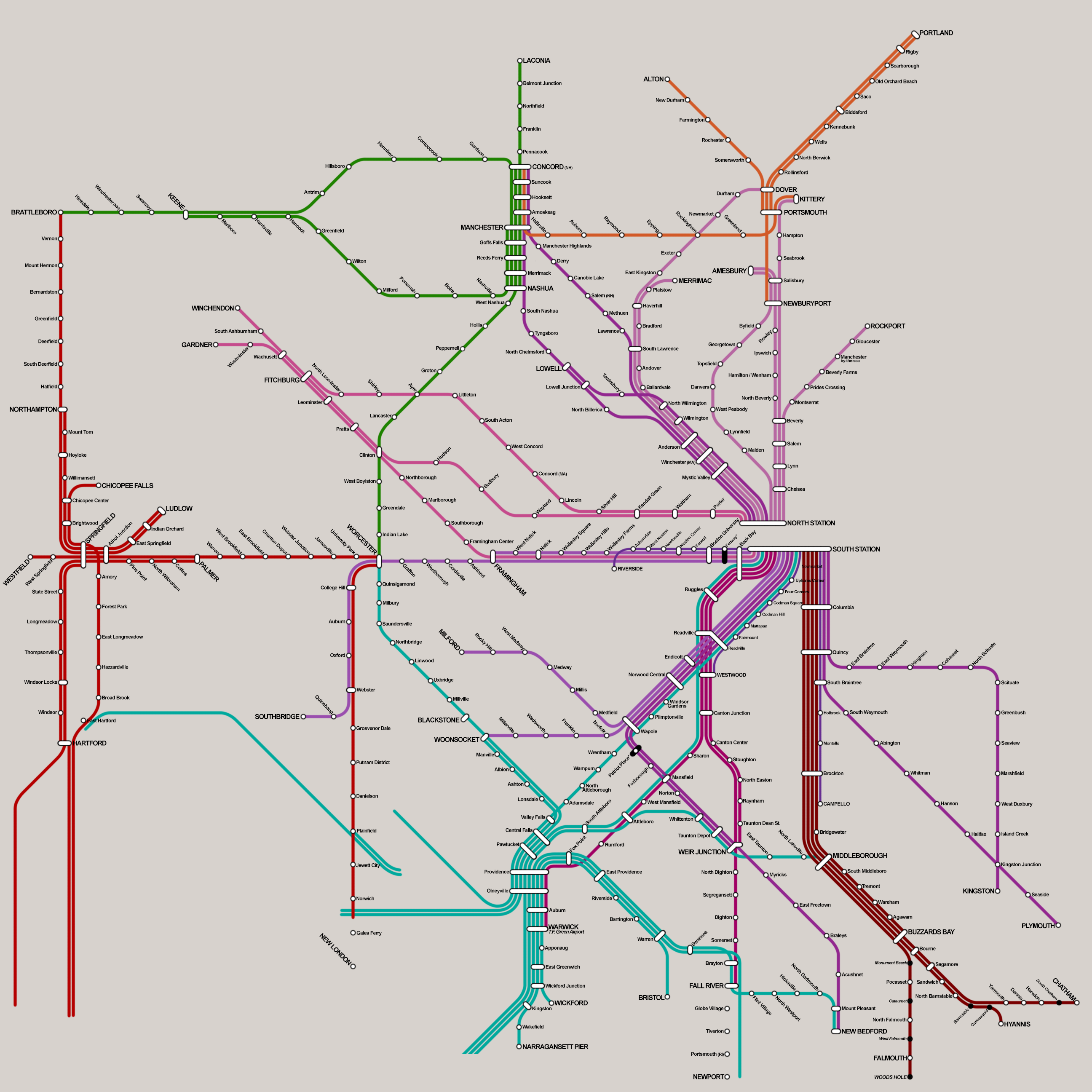
I'm going to play a quick devil's advocate with regards to this whole enterprise. I have no beef with systems centered around Providence, or Springfield, or Worcester, or Nashua/Manchester/Concord. I'm also not opposed to responsibly enlarging the commuter rail out of Boston. But I don't get the need for the density and interconnectedness among all these systems. Is anyone really commuting along these patterns? Headways are never going to be so frequent on a commuter system like this that the transfers will be worthwhile for anyone. It's a pretty fantasy map, but I'm not sure what kind of fantasy it is, exactly...
 

Back
Top