Crazy Transit Pitches

It's been discussed at length back-thread. Basically, Essex is a shitshow and maybe not worth the hassle if we can get around it using the Tremont St Tunnel to TMC, and wrap around to the Transitway via Marginal/Curve/Hudson/etc. That way you can also use TMC as a jumping off point for GL->BBY->Huntington Ave Subway, as well as GL->Washington St->Dudley.

Here's a sample of just a few of the many posts that have gone into detail (I single out F-Line's posts because they're lengthy, and easy to find):

http://www.archboston.org/community/showpost.php?p=196382&postcount=1874

http://www.archboston.org/community/showthread.php?p=183986&highlight=Green+Marginal#post183986

If Essex is studied and rejected, something like this would likely be the next best option. Should definitely be studied for feasibility.
hGZISdm.png
 
One correction. The Orange Line crosses further down the block, almost splitting the Shawmut/Marginal intersection. http://goo.gl/maps/xVJqs. See how the Washington/Marginal tall half of the Quincy School complex and the high-rise on corner of Oak/Washington--with low-slung building in the middle--give the distinct perception of something underground splitting that block diagonally. That's where the Orange tunnel is.

To clear it you'd need to do a little tidy-up:

-- Cut the Green Line diagonally across the courtyard on the Shawmut/Marginal corner so it slips under Orange at the least-impactful 90-degree angle.

-- Have the Washington St. branch tunnel fork off on a dead-straight Pike-crossing trajectory off that diagonal cut while the SS/Transitway branch curves the rest of the way onto Marginal.


I think there's a link somewhere on one of these threads from studied 1970's alignments that was pretty much spot-on this Marginal slip under the then-empty Orange cavern. The only portion unstudied by either way old proposals or SL III is the Curve St. to Essex/Chinatown Park portion.
 
Thanks - I know I've seen a lot of press on here about this from time to time, but have no idea where in the threads all this talk is buried... And looking at the links I have seen them before!

My thoughts, still, are that a Marginal St loses more in opportunity than it gains in cost savings. The biggest benefit out of the Essex Street way is it allows a direct Green Line AND Orange Line connection. The bulk of GL traffic comes from the west, and in F-Line's, your and davem's schemes it looks like someone coming from Kenmore would have to either transfer at Boylston to head south and then connect to the Seaport-bound line on another transfer. Also, I don't see the utility in having the extra connection to the E-Line, seems like extra michigas.

This is "crazy"... or is it? It just seems to me that the Essex tunnel is critical to make this work the best. Otherwise it ain't worth it. At any rate, it's my version of this pitch, for better or worse.

The problems with the SL III Essex alignment had more to do with Boylston station than Essex St. itself.

Because it intersects Boylston at a 90-degree angle and Boylston is already structurally 2 levels due to the abandoned incline it would've required burrowing way way down deep under the whole thing, hollowing out a station cavern and escalators to the upper level, then creating a very tight bus loop to mix traffic from the Washington St. portal and change the alignment for a sharp turn south on Charles St. Ext. That's where all the burial grounds on the Common ended up getting disturbed.
Essex was extremely hard. Boylston Under was lethal. The buses also would've been so slow that it was unclear this and the Transitway would ever be more than one continuous 5 MPH traffic clog limiting headways.

You can improve the situation under Essex by trolley tunnels being narrower-dimension, tighter turning radii, and steeper-grade. So physically getting to Boylston is easier.


Getting into Boylston...still a big problem on LRT. Because the hook-in on the outer tracks goes south of the Essex block to hook it into the station you have to deviate south 1-2 blocks anyway to find an insertion point. Simply blasting through the wall of the current Boylston station at an at-grade triple junction is going to completely hose the entire Central Subway every direction.


So...you can't just replicate all of the (bad) BRT plan with something that ends up equally bad. The point of failure is still what do you do when you're knocking on Boylston's door. The straight-on-a-map routing completely on Essex doesn't have a viable interface with Boylston without breaking something that can't be fixed.


You must turn south off Essex and go around the block to hook it in via trolley.

-- Washington St. is the Orange tunnel...can't be that block. Which means you're also not going to have an easy upstairs/downstairs Chinatown connection.

-- You could skip Essex and go for Beach/LaGrange then bang a right on Tremont in the middle of the old trolley tunnel. That's going to be pretty goddamn ugly street digging, too, and require destroying a part of the old tunnel. And you have to have a looooooong connecting walkway to tie to Chinatown. My guess is the costs are even worse here.

-- You could go up much wider Kneeland and Stuart Streets and hang a right onto Tremont. Also requires destroying a part of the old trolley tunnel...this time where all the multi-level flyovers are. And you have more building mitigation around Hudson St. to take care of. No Chinatown transfer here...have to have a long connecting walkway to Tufts instead. But it does lot less than Essex or Beach/LaGrange and doesn't destroy Boylston and the Common.


Or...you can just avoid destroying any part of the trolley tunnel, keep going straight down Hudson to Curve, then up Shawmut to pick up the old tunnel under Eliot Norton Park. With a Tufts Green station there and connecting walkway to the Orange walkway inside of fare control. It'd be a long walkway, but not as long as on the Stuart route or the Beach/Lagrange route's walkway to Chinatown.


Any which way there's an Orange transfer. It's either Chinatown or Tufts. You were never going to be able to get a one-seat from Kenmore under any proposal. The Tremont trolley tunnel points downtown-only, and you would've had to transfer deep in the cramped cavern under Boylston to ride the 5 MPH bus around the loop to get there on SL Phase III. Nothing's gained or lost here because it was never physically possible in the first place on any mode.

It is a reliable assumption that the former sealed underpass at Boylston between the two platforms (lasted until the mid-70's) would be re-dug and ADA'd like the Park St. underpass to permit cross-platform transfers from all the westbound branches. That was the purpose that Boylston underpass served when the South End branches were still operating. It'd be a whole lot less painful to dip under and cross platforms to reach Seaport from Kenmore than it would be to ride a Porter-esque escalator into the Silver Line cavern.
 
OK - so as per the older maps, you have the New Line running Dudley to Seaport via Tufts (Tufts being a sort of combo station). When I lived in London the Monument and Bank stations formed a giant double station, and even within Bank proper, transfers from the Central to the Northern required a lengthy walk but it was really no big deal and nobody ever thought twice. So I don't think this part would be a problem at all. If you make the T map show it as one station, psychologically people will not notice the walking as much.

My question is how you run the western Green lines. What line are people crossing under this newly reopened Boylston track underpass to get to? I assume we are saying that some trains coming from the west would continue past Boylston and down the Tremont subway? If so, would this line then turn back? Would it continue to Dudley? To Seaport? Both?

The West branches are same as they ever were. Like today when you have to switch platforms at Arlington to get from a B/C/D inbound to an E outbound...Boylston now becomes the station of choice for switching from a Kenmore-originating B/C/D train to a Seaport outbound. Not much you can do about that because 115-year-old tunnels point where 115-year-old tunnels point: towards downtown, not universal-direction. But the practice of platform-switching in that manner is old hat in Boston.

How Tufts would work is that there'd be an Arlington/Berkeley-style long concourse between fare Green and Orange lobbies because they aren't on the same block. But as noted if the Essex-only routing right underneath Chinatown doesn't give you a hook-in angle to Boylston there is no trajectory where a simple upstairs/downstairs is doable. So there was always going to be a long walkway. This particular long walkway is shorter than the other possible routings into Boylston. It would be entirely behind fare control, so the transfer is totally free. Think a 200 ft. shorter version of the Winter St. Concourse between Park/Green and DTX/Orange+Red. Not a difficult walk at all. Actually pretty convenient for getting from the Green Line to the hospital lobby fully climate-controlled.

And as you noted, on the spider map and signage the stations would appear unified and totally logical.
 
I'll just repost these. There were issues which were discussed at length, but it's the general idea.

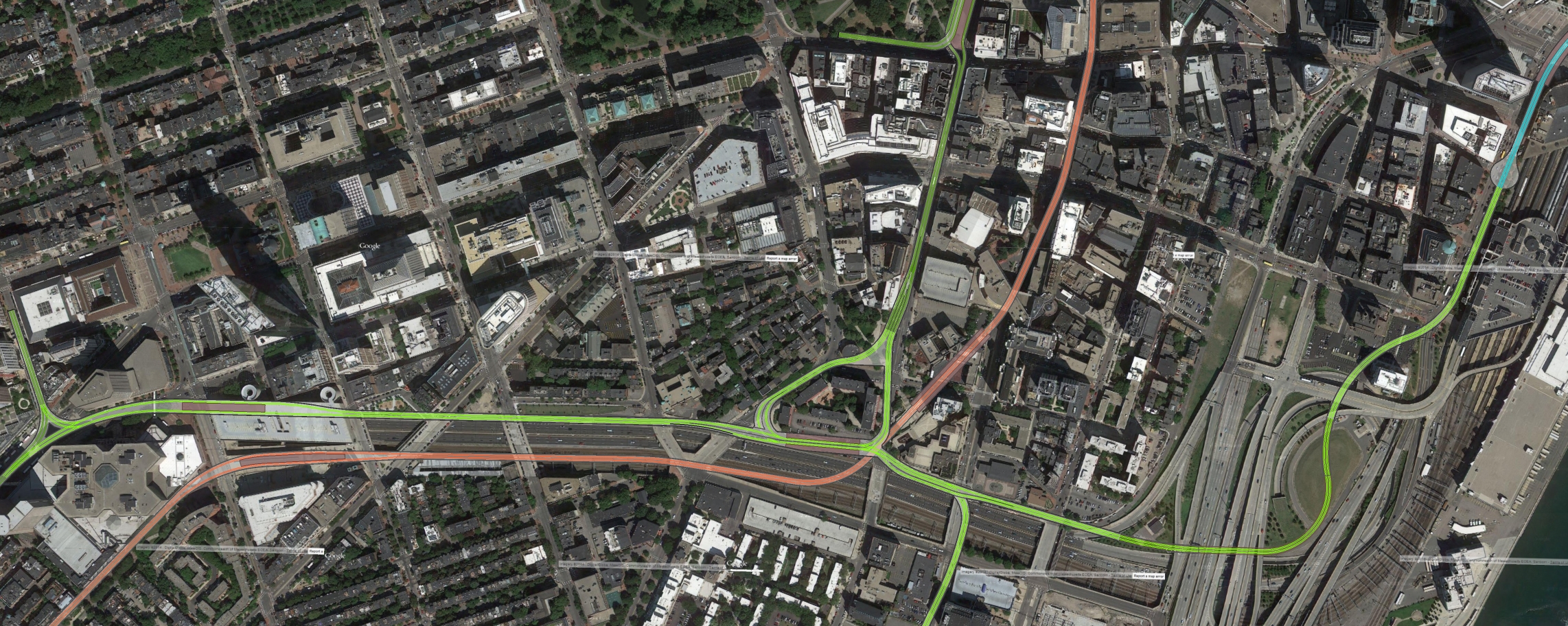
Overview, from Copley to South Station: (click for the big-ass version) Dark Green are the existing GL tracks, light green are new.
12297180024_326f2fd3da_o.jpg

Note that the existing Copley Junction could be made into a wye, allowing it to be used as a big back bay loop. I'm also not showing the existing Boylston St subway, the Red Line, or Chinatown station.

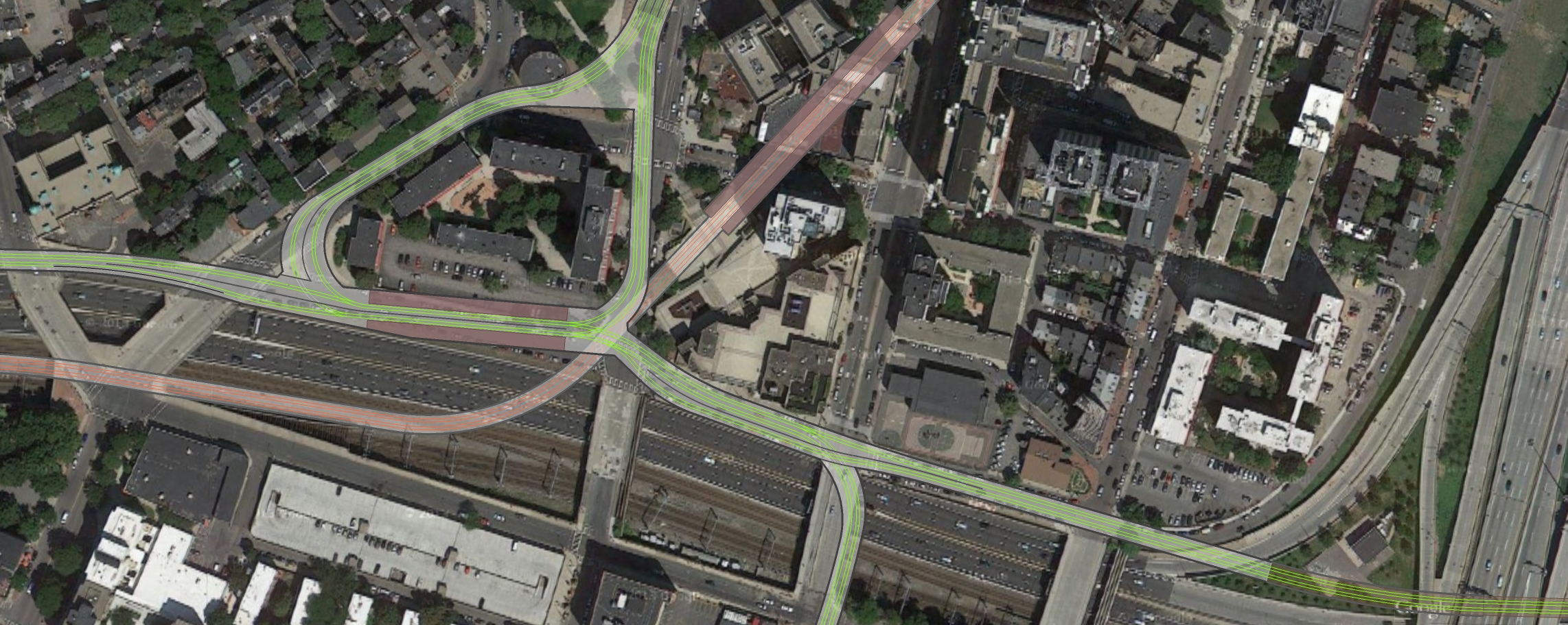
Close up of the new Bay Village Station, minus passages from Tufts and back.
12297177964_5320e44e82_o.jpg


Possible routing from Marginal St to the existing SL loop (the location of the SL loop is taken from construction documents, I'm 98% sure that's where it is). There may be issues with clearance with all the tunnels through here:
12308714873_27dc87fbfa_o.jpg


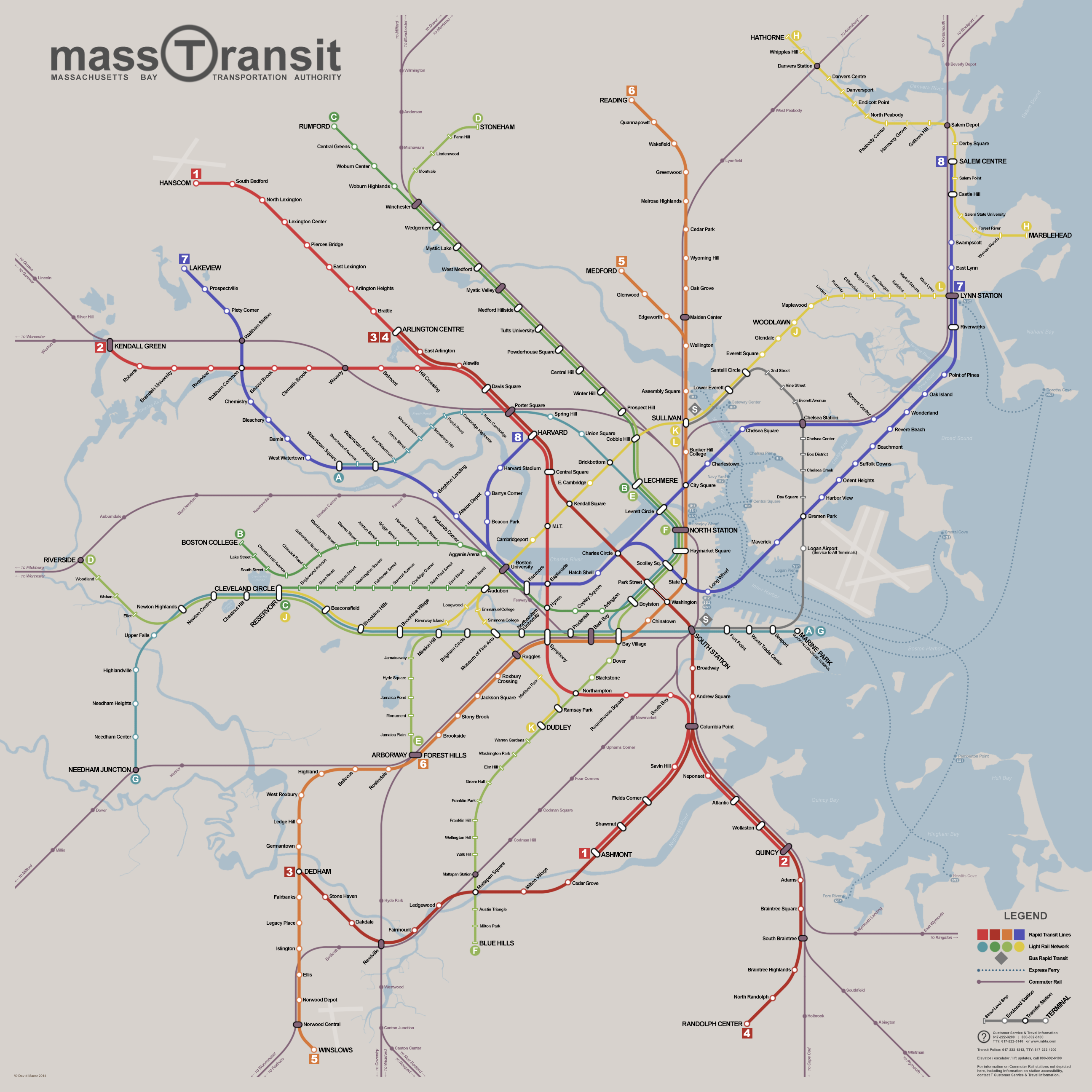
And a map I created that, among many other things, uses this new connection fully (This also assumes construction of the D-E connector in Brookline Village):

13549109643_ca7dc7bc32_o.png


Basically, trains from the west can now either run into the Tremont tunnel via the Huntington Ave subway, or keep going straight and terminate in the seaport. You actually get more connectivity this way than the essex street routing, since you now get two/three (I'm assuming Symphony is connected to Mass Ave) orange line connections, as well as the connection to the CR at Back Bay.


For the whole conversation, go back to page 94 and keep reading. We all go back and fourth there, F-Line and others found issues with what I was doing, lots of fun. I forget the conclusions we all came to, but these were the latest graphics I had on the idea.
 
Last edited:
This scheme makes a lot of sense with the second Back Bay subway. If you can have that then any advantage Essex would have over Marginal Rd. becomes irrelevant. However, there is a whole lot to cobble together here to make any one piece make sense. There is a lot of sacred ground covered here too. The legal and political hurdles of digging up the Back Bay and Bay Village might make the engineering challenges on Essex look as easy as duck soup.
 
This scheme makes a lot of sense with the second Back Bay subway. If you can have that then any advantage Essex would have over Marginal Rd. becomes irrelevant. However, there is a whole lot to cobble together here to make any one piece make sense. There is a lot of sacred ground covered here too. The legal and political hurdles of digging up the Back Bay and Bay Village might make the engineering challenges on Essex look as easy as duck soup.

Well, this is several different separate projects spread apart by decades. For Seaport you only build Tufts station and the route to the Transitway. None of the rest applies. Maybe put a notch in the wall for splitting off the Washington St. portal tunnel so the Silver Line Washington replacement is provisioned, but completing the actual Pike crossing and incline to surface for that is a separate and unrelated project.

BBY subway hooked to Huntington is a whole different thing. Out-of-sight/out-of-mind until you're ready. The Tremont tunnel is a 4-tracker at the flyover ramps so it has the capacity to sort traffic for multiple diverging branches. That's the only reason why the 'parallel flank' is in-play for the deep future. And you would be able to thru-route to the Seaport on the parallel flank. But, likewise, separate project. Separate funding. Decades later after you've digested the really critical downtown stuff.


Those fantasy maps are just an amalgamation of all these independent builds strung together. Don't want to give any false impressions that it's a part of the Transitway link, because that project only involves Eliot Norton Park + the station then Marginal and around the horn...nothing more.
 
Possible routing from Marginal St to the existing SL loop (the location of the SL loop is taken from construction documents, I'm 98% sure that's where it is). There may be issues with clearance with all the tunnels through here:

For the whole conversation, go back to page 94 and keep reading. We all go back and fourth there, F-Line and others found issues with what I was doing, lots of fun. I forget the conclusions we all came to, but these were the latest graphics I had on the idea.

So the thread peters out around where the portal is feasible for connecting with South Station/emerging from under I-93. I'm curious if there's been any further thought on exactly how this might be done?

Boylston now becomes the station of choice for switching from a Kenmore-originating B/C/D train to a Seaport outbound.

Let me understand the logistics of the davem and F-Line proposals (and omitting the Huntington connection, for now and assuming only a transitway extension). From what I see from the images:
- trains coming from Dudley would join the rest of the Green Line at Boylston and keep going north
- trains coming from the west stay the same, as stated, so you transfer to get to the Seaport, but
- some trains coming from Lechmere would split off at Boylston and head either south to Dudley or east to Seaport?
- it does not look like there would be a Dudley-Seaport direct line, sans transfer

Second question - the BRT in the Seaport transitway needs to be kept so as to allow for airport and Chelsea trips, so we can't just get rid of the bus loop at South Station for a portal - if we can't through-route Dudley buses straight to South Station without a transfer, AND use the bus loop in SS for a portal, the bus loop needs to be moved somwhere else. But if we can make a Dudley-Seaport, can the Tremont tunnel be reworked to accommodate both buses and rail?
 
So the thread peters out around where the portal is feasible for connecting with South Station/emerging from under I-93. I'm curious if there's been any further thought on exactly how this might be done?

It tends to peter out because there's disagreement over exactly where the transitway turnaround is. Some documents put it under Atlantic by the Bus terminal, while others put it under the intersection of Surface, Essex and Lincoln.
 
So the thread peters out around where the portal is feasible for connecting with South Station/emerging from under I-93. I'm curious if there's been any further thought on exactly how this might be done?

A very embryonic sketch of the Marginal St. around-the-horn routing was studied in the 1970's. Although back then they were thinking Washington St. light rail with a portal on Marginal. No intermediate station, but that is feasible with the room available and the streets from Eliot Norton Park to the Pike cleanroomed underneath by the Pike urban renewal nuking and rebuilding all the blocks south of there. So everything from Boylston to where it crosses under the Orange Line on the corner of Marginal is grounded in real study and real feasibility.

The Transitway stuff...they studied a zillion different routings. And it changed the more obstructions they found. Because BRT was decided early they didn't bother with a lot of those around-the-block routings for reaching Boylston via the old tunnel and committed themselves hell or high water to the deep cavern. Which is of course ruled impossible now.

So...a re-study is in full order. Based on what is known about the Transitway being able to safely reach the other side of 93 at Chinatown Park and the LRT tunnel safely being able to make the turn under Marginal (per the 70's study)...simple path of least resistance points all eyes to the Marginal + Curve + Hudson St. routing between the two proven-studied endpoints of the alignment. Hudson around Kneeland might be a little tricky for building impacts, but everything else under those streets was either cleanroomed in the 60's by Pike-led urban renewal wiping or Big Dig wiping.

You do have to do the full study to know for sure if this will work, but logic dictates it is the most plausible, least impactful, and least-costly of any of the available options.

Notching the Washington St. portal and crossing under the Pike and NEC is also no biggie. The 70's proposal didn't do that, but there is space now vacated on the Herald St. wall of the NEC pit on the Shawmut-Washington block where the Boston Herald's old freight siding started. Just a couple electrical boxes that would have to be relocated. The Orange tunnel is under the NEC on the Shawmut-Tremont block and the North-South Link portal would be on the Washington-Harrison block, so you're all clear to burrow diagonally under the Pike and NEC on the Shawmut-Washington block.


Let me understand the logistics of the davem and F-Line proposals (and omitting the Huntington connection, for now and assuming only a transitway extension). From what I see from the images:
- trains coming from Dudley would join the rest of the Green Line at Boylston and keep going north
- trains coming from the west stay the same, as stated, so you transfer to get to the Seaport, but
- some trains coming from Lechmere would split off at Boylston and head either south to Dudley or east to Seaport?
- it does not look like there would be a Dudley-Seaport direct line, sans transfer
Correct.

-- Union or Medford would feed the Seaport and Washington instead of the D and E. Probably Medford-Seaport having the highest overall demand and Union-Dudley being the easiest to dispatch. And of course if any portion of the Urban Ring north gets built as LRT interacting with Lechmere you get a whole blender of potential routes. You want this because the GLX carhouse is your primary vehicle supply for these 2 potential South End branches, so logistically that's the only plausible way to feed it.

-- Tufts station would be the branch split station between Washington and Seaport. That way Orange patrons have access to either one.

-- West branches stay the same. The Boylston platform underpass gets restored for branch transfers from a B/C/D/E inbound to a Seaport or Washington outbound. But B/C/D passengers already do a similar move at Arlington for reaching the E outbound so that's not a new inconvenience. By having a one-seat covering all of North Station-Park to Tufts, SS, and the Seaport you sharply reduce the hordes of who have to transfer at Park and GC, reduce the dwell times, and improve the flow. So this helps the West branches through the worst traffic clog on their routes where all the delays come home to roost. They're not excluded from the party; they get beneficial relief of their own by cleaning out Park and GC a lot.

-- Washington-Seaport doesn't get a one-seat. But they never asked for one in the first place. That was some shotgun marriage baloney the T forced on them to meet its "equal of better replacement" for the Orange Line El teardown while just giving them a city bus. There is no high-demand ridership pattern. And actually, that contributed to SL Phase III's failure in the form of that turning loop under the Common. They ended up having to loop a lot of buses on the halves of the service because the tunnel was too slow and that was the only way to keep adequate headways on each half. So in reality...only a small minority of the buses would actually run thru complete from Dudley to the Seaport/Airport. Most would loop in the middle so the flawed tunnel speeds didn't murder everyone's headways. So...yeah, no loss there. Nobody asked for it, and what they were actually promised was a very hollow promise.

Second question - the BRT in the Seaport transitway needs to be kept so as to allow for airport and Chelsea trips, so we can't just get rid of the bus loop at South Station for a portal - if we can't through-route Dudley buses straight to South Station without a transfer, AND use the bus loop in SS for a portal, the bus loop needs to be moved somwhere else. But if we can make a Dudley-Seaport, can the Tremont tunnel be reworked to accommodate both buses and rail?
No place to portal-up near SS. Too much of a mess underground, too constrained on the routing west. That was also conclusively proved in the SL III engineering. The portal could only be by the Mass Pike in the South End because of lack of opportunity to pop up any sooner, and that also necessitated the Boylston Loop carving up the Common...which was the project's ultimate undoing.

So no...you can't fit both modes past the existing SS loop because of the portal issue. Nor would you really want to the way that drove up construction costs on Essex and the way it killed speeds all the way to Boylston. A trolley tunnel can be narrower, faster, with tighter curves. Between Shawmut and Essex you could easily hit 40 MPH in the tunnel, and the abandoned tunnel was the fastest segment of the original subway at the flyovers. The roundabout routing would be way faster than the 5 MPH bus under Essex. The trip from Boylston and Tufts would be akin to the Huntington tunnel between Prudential and Symphony where they really kick on the afterburners in that way under-capacity tunnel stretch.
 
Crossing from the northbound platform to the southbound/westbound platform at Boylston is not feasible. If I remember correctly, the stairs are narrow and will permit only one person at a time and the passageways are narrow and smelly. You'd have to go to Park Street to cross under; there's even enough room for escalators. (Sort of like having to go an extra top because you can't cross at Copley)>
 
Crossing from the northbound platform to the southbound/westbound platform at Boylston is not feasible. If I remember correctly, the stairs are narrow and will permit only one person at a time and the passageways are narrow and smelly. You'd have to go to Park Street to cross under; there's even enough room for escalators. (Sort of like having to go an extra top because you can't cross at Copley)>

These wouldn't be the old passageways. Those were filled in to support the weight of the heavier LRV's passing above, so they don't exist anymore. They'd have to re-dig a new, wider underpass.

It can be done. There's adequate room for it.
 
So the thread peters out around where the portal is feasible for connecting with South Station/emerging from under I-93. I'm curious if there's been any further thought on exactly how this might be done?

As Busses said, we can't pin down exactly where all the underground infrastructure is there without an official survey. I'm pretty sure my location is accurate as I based it off an official MBTA report I found, but it could have been outdated. I also have no idea where all the tunnels for I-93 and the associated ramps are, but I'm sure there is some way to shoehorn a ~30' wide tunnel through there. IIRC, the allston interchange project got announced right around then too.

Let me understand the logistics of the davem and F-Line proposals (and omitting the Huntington connection, for now and assuming only a transitway extension). From what I see from the images:
- trains coming from Dudley would join the rest of the Green Line at Boylston and keep going north
- trains coming from the west stay the same, as stated, so you transfer to get to the Seaport, but
- some trains coming from Lechmere would split off at Boylston and head either south to Dudley or east to Seaport?
- it does not look like there would be a Dudley-Seaport direct line, sans transfer

Yes, yes, yes and yes. Additionally, trains could loop at Bay Village and head back north. Really, all this is doing is reopening Boylston and the Tremont Tunnel to it's originally designed capacity.

Obviously an official survey would have to be done, but "seat of pants" I just don't think there is/will be much of a demand for Dudley-Seaport. It's part of the reason I always thought the whole SL phase III thing was really stupid, Dudley has always been connected towards Haymarket, that's where the demand is, not to the seaport. I think a fast connection to the OL at Bay Village, combined with continuing service towards Medford & Somerville will be far more useful.

Really, all the new Dudley branch is doing in recreating the brief period when the old Main Line Elevated (today's orange line) ran through the Tremont tunnel while the Washington Street tunnel was under construction. 100 years and we're just getting back to what was.

Additionally, even without building the Huntington Subway, you could technically run Seaport - the back bay, just in a convoluted manner. If you ran trains from the Seaport to Park St and around the loop, they could head back down the Boylston subway. Perhaps not a regular service routing, but if there are massive events at the BCEC its doable, and still makes more sense than the stupid Widett Circle DMU debacle.

Second question - the BRT in the Seaport transitway needs to be kept so as to allow for airport and Chelsea trips, so we can't just get rid of the bus loop at South Station for a portal - if we can't through-route Dudley buses straight to South Station without a transfer, AND use the bus loop in SS for a portal, the bus loop needs to be moved somwhere else. But if we can make a Dudley-Seaport, can the Tremont tunnel be reworked to accommodate both buses and rail?

Dudley would have to be light rail, with the BRT looping at south station. The portal would have to be after the loop, or the rail would have to split off before it. Again, we don't know exactly where the loop is, so it's hard to nail down exactly what has to happen.

As I said above, I do not believe there is much/any demand for Dudley-Seaport. For 300 years Roxbury's demand lines have been oriented to Haymarket. The Dudley-Seaport routing was just a convoluted way to tie two unrelated projects together, which is why SL PIII is such a debacle.

Even if there is a demand for Dudley-Seaport/South Station, that trip has required a transfer since the Atlantic Ave elevated came down in the 1930s (for insufficient ridership, so there wasn't even much demand then, at the peak of rail ridership, when South Station was the busiest terminal in the country). So it's not like a transfer would be anything new. And this transfer would be underground, in a fare controlled area, unlike the current crapshoot.

There is also the possibility that they could reconnect the portion of the summer St concourse above the red line that runs from Park - South Station that was severed when the Dewey Square tunnel was constructed. The T currently uses that area beyond the DTX concourse as a money counting room, but I'm sure a passageway could be shoehorned through there if there was really that much demand.
 
Thanks, guys.
Very cool, indeed. If only our great Commonwealth (in concert and with some fed contributions) could just cough up 15 or so billion for a few excellent projects. Thinking about it, I totally agree that there's no need for a one-seat from Dudley to the Seaport - as long as Dudley gets a strong access to the core. The plans above retain the BRT cross-harbor, but would really expand access to the Seaport AND relieve so much pressure on multiple stations. And, as I mentioned in my own post, getting light rail to Dudley ought to relieve the Orange Line somewhat, especially at Ruggles, as well as take a LOT of pressure off all the buses that feed in from Dudley -> Ruggles.

At this point, if I seized power in a military junta, I would:
- do this
- Blue-Red connector
- Blue Line to Lynn (I believe it's been discussed how this would relieve a lot of bus traffic; I would do it because Lynn is hard up and way too close to Boston to not have decent transit access)
- the goddamned NSRL

Then,
- another big project: some kind of second Green Line trunk, ?under Stuart although I suppose the Huntington connector outlined above would also work
- Green Line extensions via GJ to Union Sq, and
- to Hvd Sq via Beacon Yds, under the river and all the way


... in all seriousness, I really would like to see them restudy this. The Seaport is only half built but already a total disaster. I dont think the miraculous discovery of that ramp nobody takes (for whatever reason) is going to solve it in a meaningful way.
 
Would Silverline busses and greenline trolleys both running in the Transitway cause any issues? As has been noted, the Silverline busses move a lot slower than a trolley would, would it cause service disruptions to the greenline?
 
In other places, even in the USA, such as Seattle and Pittsburgh, they successfully mix light rail and trolleybuses in the same tunnels.

So it is possible.
 

Back
Top