Crazy Transit Pitches

A question: Is it possible and/or desirable to enlarge the red line level of the Park Street Station to increase the number of tracks within the station to four, extend the station closer to Beacon Street and put a Red only headhouse adjacent to Beacon Street?

Enlarging laterally isn't possible because of the delicate underpin of the older Green Line level. Extra tracks aren't possible (even as turnouts for one station only) because Winter St. isn't wide enough to widen either the Red or Concourse level with the adjacent building foundations. Extension past 6 cars is possible, as they'd just notch the Charles-facing tunnel like they did in 1987 to extend the far end of the platform. However, other stations like DTX are way structurally harder than Park to lengthen so 8-car trains aren't a very realistic target.

There CAN be a Red-only egress from the far end of the platform by converting the current emergency exit to the Common into a narrowish but full-service egress. That is very much worth an engineering study, as it would be meaningful dwell-taming for reasonable price...with no structural blockers upstairs for widening the emergency stairs and shafting an elevator. You'd also be easily able to notch the walls on the 2 side platforms for stairs/elevators to join to the upgraded center-platform stairs at a small mezzanine right above the ceiling. Headhouse would be on the Common midway to Beacon nearish the Park St. side. Google Maps marks the spot with the emergency exit grate right by where couple of the paths cross. Headhouse would be small...maybe slightly smaller than the far-end secondary Green entrance with just a couple fairgates. But it would legit be more convienient by a lot for the State House side of the block.

It puzzles me that State-DTX ped tunnel future studies get talked up more than this. Simple engineering report would be pretty easy to rip out on this, and then the costs and impacts are self-contained enough that it's a simple up/down decision on whether to proceed. As low-hanging fruit it's a good one.
Thanks!
 
And here is where that secondary Red headhouse would go, atop the current emergency exit grate with enough widening for twinned single-file up/down escalators or stairs and an adjacent elevator shaft. It's 225 ft. WNW from the Green outbound-side headhouse, and upslope quite a bit on the Common (Street View sorta conveys the grade, but the hill is more pronounced walking it in-person). Placement by the two paths--including the one carrying the Freedom Trail--going to the State House gate plus the northwesterly path to the Joy St. gate makes it considerably more convenient wayfinding from Beacon than the main Tremont St. headhouse, as well as saving a little bit of sweat from walking up the complete hill. It would get a lot of usage due to those advantages, and that significantly tames the platform dwells by spreading the crowds out with better utilization of the far end. Right now because the Green IB/OB and Winter St. egresses skew so heavily to the first 3 cars on the DTX-facing platform ends the crowds bunch to that end to such exaggerated extreme that all flow gets hosed. Trains can't close doors and people are stuck like stranded cattle by the stairs despite the fact that the platform by the 1-2 cars on the Charles-facing platform ends might be simultaneously deserted. Give them an egress at that end so they have a reason to jockey for position at that end and the crowd re-spreads to sanely utilize the whole platform, de-bunches itself to a huge degree by the existing unexpandable egresses, and the dwell time drops dramatically from the rebalance by MORE total people being able to coexist on the same platform without getting stuck and trains being able to close doors sooner with those alleviated backups no longer backing up straight onto the train.

If an engineering scoping report gives the all-clear on feasibility of digging up to widen those emergency stairs and shaft the elevator through Common soil (and I don't see why it wouldn't...there isn't so much as a single tree that would need to be cut down), for the price it's one of the no-brainest of no-brainers to go for it. You can't structurally do anything else to Park that's going to physically enlarge it, so redistribution of platform crowding 'is' the only big pivot left to reach for. Given just how specific the conditions are that encourage Red-level crowd bunching by the current egresses this emergency exit upgrade punches far, far above its weight for what it accomplishes in direct service to that one last meaningful pivot. I really hope it dawns on them ASAP that they need to task a study team to issuing that engineering feasibility report. It wouldn't take all that long in real time to go from scoping-->design-->build, and the construction area affects such an extremely small/inconsequential tip of the existing station that they can probably take their sweet time working away without fouling more than 1 door (if that) on the rear-most underutilized car berth of the station at any point during construction.
 
Last edited:
Maybe the underpinnings for the Green Line would prevent this, but I have always thought a head house there, and also a switch back to the green at the far end of the platform would do wonders for crowding.
 
A note about Park Street: the 1970-closed Temple Place entrance (to the GL side platform) is supposedly getting reopened as part of the station improvements, though the MBTA hasn't released any more information than that. That should help a bit with crowding at the NB Green Line headhouse
 
A note about Park Street: the 1970-closed Temple Place entrance (to the GL side platform) is supposedly getting reopened as part of the station improvements, though the MBTA hasn't released any more information than that. That should help a bit with crowding at the NB Green Line headhouse

Temple St. entrance, 1936-70. . .
CiLIeuDUUAARiOW.jpg


Very similar in appearance to the Arlington stairs. When it closed they just sawed off the tops of the staircases and left them as a pair of raised grates on the corner.

Interface with the platforms, 1948. . .
Park_Street_station_plan%2C_1934.png


Speaking of old stuff possibly remade new @ Park...they did have the outer loop track in-service until 1964 when it was "temporarily" disconnected to install the thru-service outbound crossover to the fence track. It was considerably wider than the tight inner loop, and they used both loops when Watertown and South End service also turned at Park in addition to Arborway (plus many other service patterns in the early days). They had plans on the books for a couple decades after to reconnect it, presumably in anticipation for modern LRV's being deployed to Arborway where the faster turnaround time would've been advantageous and also because Watertown restoration was being fought in the courts. But they kept punting because there was cost involved at relocating a support beam or two for the reconnection, plus the intentional malingering at not installing pantograph-compatible wire to Arborway made the labor somewhat wasted when the inner loop was just fine for a PCC-only service pattern (even dithering into the early-90's on bringing the line back with PCC's).

Now that they are committed to doing a little bit of structural reworking for the matching inbound-side thru crossover, would there be enough structural allowance to kill two birds with one stone by reconnecting the outer loop so they can retire that inner loop? It would still be a tightish radius, but a healthy improvement over the ruling curve of that inner loop. I just wonder how many additional support beams they'd have to touch to throw down a new inbound crossover switch and a reanimated outer-loop switch since the interlocking for both would be *hella* tight. It hasn't appeared on any of the GLT slides, all of which retain the 47 ft. radius inner loop and make no attempt at reaching for the outer one. Which probably means it isn't a super favorable engineering assessment. Although the miss on spacing for that interlocking is close enough that it may be well worth the extra cost incurred of moving a couple more support beams and trying for it again if that opens up more off-shelf leeway for the next cars. We're talking near enough that it isn't physically impossible at all...just probably overshooting a cost target by a modest if annoying amount. It wouldn't be operationally as flexible as the total traffic separation on the inner loop as trains off both tracks would have to cross the same switch whether proceeding thru (i.e. vast majority of service) or cutting short. But if B's are planned all along to return to GC after the inbound crossover goes live then the actual conflicts would be minimal because nothing regular would be turning here. It would just be the "operational flexibility" safety valve they state for-the-record that they crave for cutting late runs short. They'd have to maintain that new crossover+loop inbound interlocking like their lives depended on it because the loss of loop vs. thru track separation means things are really going to get hosed bad in a signal fault or the inevitable once-every-few-years slow-speed derailment on that new switch. But I still think that it could end up being well worth it to try in the end if the outer-loop alignment nets a more advantageous ruling curve that increases aggregate reliability more than one vulnerable single-point switch risks it. Tight as that switch is, it's not going to be thrown in the loop direction anywhere close to enough times per day to accumulate the wear from turning cars that'll make it any sort of fault-prone concern.

The GLT team should at least show the engineering assessment about whether trading back to the outer-loop alignment can or can't be done in tandem with the inbound crossover work. Because until at least as late as the RFP for the Type 7's 37+ years ago they still had those extant mothballed plans to reconnect it even while they were also toying way back then with the inbound crossover idea. If something has changed since then that physically blocks the idea at any level more final than a medium budget concern, it had to have been something more recent like not wanting to risk sending newfangled low-floor trolley trucks through an interlocking that tight. Because dimensionally it was still possible well into the LRV era to do that outer-loop reconnect project.
 
Here's a couple of questions:
-Could they further build out Park further southwest as they did in 1914 and remove the current loop area for rebuilding to make a bigger loop/streamlining?
-Could Tremont handle quad track to Government Center to Park?

All in all, does Park need to be the short turn or can/should Govenment Center play that role? Does Park need a loop at all?
 
Here's a couple of questions:

-Could they further build out Park further southwest as they did in 1914 and remove the current loop area for rebuilding to make a bigger loop/streamlining?


Theoretically they can keep extending Park so far west it outright eats Boylston and becomes its own superblock-spanning combo station. There's nothing atop it except Common sidewalk so they can widen the tunnel for 4 tracks/2 endless islands all the way to the top of the abandoned outer outbound track incline...then move the Boylston inner/outer crossovers over a small cut-up rump of abandoned Boylston platform to match current 2-station switch layout to the replacement "super-Park". Now, there'd be even less compelling a customer reason to do that than this Park-DTX superstation idea being officially floated (and spat on like a lead balloon), so while engineering feasibility is no problem with "Poylstark Station" overall value proposition most definitely is problematic and over-chasing a need that doesn't really exist. Park's platform lengths are already set for the GLT fleet, and all GL-level crowding trends to the extreme east end where the Red + Concourse interfaces are and where the main headhouse is order-of-magnitude bigger driver of foot traffic than any other current/former/future egress. The existing west-end headhouse gets very sparse as-is utilization in spite of all the east-end overcrowding, so that says all there really is to say about upside or lackthereof of the superstation idea.


Unfortunately it's all the egress-stacking on the east end that prevents any eastward expansion of the platforms and constrains the runup space for widening the inner loop and/or reactivating the outer loop. Red's 3 platforms are where they are bisecting underneath, so those stairs can't move anywhere. The entirety of the fudge factor for modding the loops lies in relocating the support beams and electrical boxes just east of the outbound RL stairs in the loop cavern. The beams aren't a major blocker at all because that end likewise is just supporting sidewalk up above, but touches to 1 beam for relocation requires corresponding touches/reinforcements to 2-3 others that aren't being moved as the loading characteristics change with the beam layout. So costs start to sail a bit the more touches you make...not to any major absolute budget blowout since it's a small/self-contained project to begin with, but definitely an unfaborable ballooning relative to the size of the project. Now, the fact that there used to be 2 loops is extremely fortunate for serving up the space to do that all-important inbound crossover that will markedly increase capacity and routing flex. There is a lot of room back there now that there's only 1 loop in-service. The remaining question is more about how much further can push it with the support beam touches to either outright swap back to the wider outer-loop alignment or just widen the inner loop into more favorable geometry on the 'tweener slack space between loops.


Absolute feasibility shouldn't be affected...but they'd have to establish pain threshold for costs sailing because that is going to require more support beam touches. The biggest concern with doing that is that the new converging switch from the inner inbound track and the diverging switch for the reanimated outer-loop track are going to be in hella-tight quarters any way you slice it. Definitely a slow zone (though at mere feet from starting spot that's a non-factor on the stopwatch to GC), definitely an elevated signal fault and derailment risk with the switches packed that close together (though flex is still way better than before having that inbound crossover at all), and *some* loss of traffic separation vs. the inner loop because all inbound traffic has to pass through the same packed switches (though not a factor with few-to-none regular service patterns ever turning at Park). But if it makes tangible difference to their vehicle purchase options to have the bigger outer loop, those tradeoffs (that aren't really real-world significant) + the modest cost bloat of touching more beams looks well worth it. It is still an open question how much if any the trade-up to outer loop alignment expands the vehicle purchase options, because Brattle Loop @ GC from the northbound side--definitely NOT an eliminable loop as it may be needed sooner as a rush-hour short-turn supplement for exploding Somerville ridership--is barely any wider. So Park Loop mods would have to be studied in-tandem with Brattle Loop mods. Brattle arguably does have some flex on its tightest spots because the segment of 'old Scollay' platform normally off-limits behind the cinderblock wall (except for Garden event short-turns) is superfluous extra length never needed for GLT and thus is fair game for eating in the name some curve-easing back there. Depends on what their Brattle options are. If they're favorable, then I think there's more pressure to bear down at Park and take a closer look at the outer-loop alignment. If the options @ Brattle are too negligible, then the extra expense @ Park isn't going to buy you an 'off-shelvier' ruling curve for new cars and starts becoming more aesthetic OCD than real-world consequential.


The fact that the GLT team is saying the inner loop is stet probably is a significant tell that all this Brattle v. Park loopage mod options don't wash out into consequentially wider ruling curve that would impact buying options, and does start teetering on waste of money. First, the inbound thru crossover is WAY more important to service levels than any other infrastructure touch so if the confines are too tight for an effective loop-or-thru interlocking priorities need to draw a line in the sand on how much is too much. Second, even though the 1964-retired outer loop has supposedly been an on-the-books reinstatement option well into the high-floor LRV era it is quite possible that low-floor LRV's (including existing half-and-half fleet) are a different story and that the loop-reinstatement ship has already sailed as a result.


Since the station layout did include the outer loop for 7 decades and reinstatement option for at least +2 decades after that, it is a natural question to ask re: what's possible in response to those FCMB slides about Park inner loop being the ruling curve guiding their vehicle purchase options. While it's quite likely they already have a well-reasoned explanation for why the outer loop isn't an option, I'd just like to see someone in a future GLT presentation to the board quickly explain it for the public record so that natural question can be put to rest. Either why it outright isn't feasible or why the support beam touches bloat a budget too much for too little gained flex on ruling curves (i.e. the Brattle Loop assessment). Right now it's a wide-open area for inquiry, so it would be good if they backfilled some detail to settle the question once and for all.
 
PART 2. . .

All in all, does Park need to be the short turn or can/should Govenment Center play that role? Does Park need a loop at all?
No regular service pattern will be using Park as a permanent turnback once the thru-service eastbound crossover is installed, because that will increase capacity enough for B's to permanently return to GC Loop. However, Park Loop is still operationally needed as a bail-out for late branch schedules so the slotting doesn't get messed up en route to GC where North Station/Lechmere trains need to slot ahead to the far-end platform berth and looping trains need to slot behind to the near-end platform berth. Though the thru-service crossover greatly increases slotting flexibility, the Park bailout is still valuable when Kenmore-Park is already hosed with cascading delays. Being able to yank stuff at Park that's already hopelessly off-schedule is a time-saver for delay recovery. While GLT's massive restructuring does an enormous amount of taming of the Kenmore-end "garbage in, garbage out" malady of mis-timed branch schedules such that law and order will more or less be restored to the Central Subway, there's still enough latent chaos remaining in the procession of surface branch schedules (simply because of the fact that they are sharing traffic signals with cars at all) that having multiple safety valves downtown for recovering from a flow disruption is necessary.

They could retire Park Loop outright if they did the quad-tracking of GC's platforms I describe in this post a page ago and have the whole works robust for regular service, but on a real 'disaster'-commute day you'll still notice a difference in longer delay recovery if the Park bailout isn't available.


Now, in terms of regular service utilizing the loop...caveat that B's soon vacating back to GC does not make Park Loop instantly expendable. Park Loop has always been a moving target of on-again/off-again service and changing makeup of services for 113 years. And the reason its utilization has been so oft-changing for a century has been because of the always elastic nature of rush-hour short-turning augmentation vs. regular run-thru service, an art that BERy and the MTA used to the hilt but the MBTA since taking over in '64 has largely run away from. The last such example was pre-1985 E service, where Arborway trains turned all-day at Park while 6:00-10:00am and 3:00-7:00pm Heath supplemental service ran to Lechmere. The great GLT cleanup and changeover to computer-assisted dispatching increases the Central Subway's elasticity for absorbing targeted short-turning service to augment the peak period. Indeed, because GLT places such heavy emphasis on taming platform dwells for keeping schedule you're very likely to see multiple new short-turn patterns TBD start evolving on the rush-hour shifts on patterns that direct-target a clean sweep of the most crowded platforms. The most obvious such example we're likely to see is D's that normally run Riverside-Medford being cut to GC at peak to stiffen service reliability while Medford-Brattle Loop comes online for the rush. But it can run the gamut, and--from the west end--isn't predictable today in 2020 where it'll ultimately be needed because crowding isn't static. When you look at all the new redevelopment happening in the city, the augmentation needs are probably going to shift around mid-2020's vs. 2030 vs. mid-2030's vs. 2040. So, like it's been for 113 years, the daily lineup of looping vs. thru-service patterns and where peak-period augmentations get targeted are going to constantly shape-shift at the half-decade to decade level.

For that reason, you absolutely DO NOT make a decision today on retiring Park Loop based on a snapshot of 2025 service. A century-plus of Central Subway service history will instantly tell you how shortsighted that is. You have to make that decision based on what offsets are available for 50-year shifts in daily demand. Like whether that ↑GC quad-track↑ scheme feasibly covers the needs through 50 years of potential service elasticity. If there's any doubt left to chance, any unknowables unaccounted for...stop immediately and hedge on keeping Park Loop. That's basically the line in the sand the GLT team is drawing. I think it's the correct stance for them to be taking.

There's one very major service pattern I could instantly see taking up residence @ Park Loop during our commute lifetimes: Urban Ring 'circuit' service through Cambridge. Run it Brattle Loop<-->Lechmere<-->Kendall<-->BU Bridge<-->Kenmore<-->Park 9:00am-7:00pm in a constant churn giving 100% Central Subway station coverage on the circuit, and don't attempt to overlap the ends with further thru-running until the furthest off-peak and weekends. And I'd make sure that it's a Park-GC circuit and not a GC-GC circuit so the ends of the line don't have to worry about staying out of each other's way on turns around GC. The way the state is struggling to refine the value proposition of West Station with its crippled RUR dinky on the Grand Junction we could well see a big Captain Obvious pivot to the Cambridge UR leg + West starter stub of the would-be Harvard branch come this 2020's decade as an LRT study. I mean, the way they're grasping at straws over what's actually capable of running to West they might have to reboot it before shovels hit ground with a whole new Service Investment Study to pin its purpose with better than dartboard-throw accuracy, so even at a pushing-paper level we might be talking about the UR way sooner than expected. Right then and there is very big add that could for all practicality's sake be taking up major residence @ Park Loop within number of years you can count on two hands and/or two feet. That up/down decision on keeping vs. retiring the loop is already fraught with bigtime future considerations fodder. Be careful...and cover thy ass for 50 years of somethings & anythings service-wise before making any decision to delete infrastructure that's been in continuous service for 113 years. Caution is extremely well-warranted, and you only have to gaze at the moment of reckoning that might be soon coming over West Station's 'vision thing' essence to see why.
 
Last edited:
Here's my idea for a Blue Line to Watertown via Charles, Kenmore and West Station. The dark blue line would be tunnel (mostly deep bore but some cut-and-cover under Cambridge Street). The light blue would be elevated on a single-pier aesthetically pleasing structure. Red markers are stations. It would greatly reduce traffic on the Green Line "Central Subway" and provide the long dreamed of heavy rail transit along an east-west corridor through Boston, restore rail transit to Watertown and allow for TOD along portions of the route. It could also eliminate the need for Storrow Drive west of Arlington Street, or at least downsize it to a narrower surface boulevard.

Conventional thinking is that we want to connect the blue line to the red line at MGH but if we're going with this plan wouldn't it make more sense to realign the blue line southward and have it meet at Park and then tunnel under the Common and Public Garden? That feels potentially cheaper than tunneling from MGH to Back Bay.
 
RBX requires tunneling under nothing but a very wide street. Getting Blue to Park Street (an idea considered several times over the 20th century) would require a large amount of tunneling under buildings, and add the BL to an already overcrowded station. Plus, the primary Red-Blue demand is Cambridge-Eastie, for which Charles/MGH makes more sense as the transfer point anyway.
 
RBX requires tunneling under nothing but a very wide street. Getting Blue to Park Street (an idea considered several times over the 20th century) would require a large amount of tunneling under buildings, and add the BL to an already overcrowded station. Plus, the primary Red-Blue demand is Cambridge-Eastie, for which Charles/MGH makes more sense as the transfer point anyway.

His proposal has the BLX being tunneled under the western side of Charles Street... I just don't see Beacon Hill going for that to get it into the Back Bay.
 

Downeaster smashed its all-time ridership record in 2019, serving 574,404 riders. Up 7.8% over 2018, and 4.9% over the previous all-time high in 2017.

Saw this in a different thread. My reply belongs here as it is a crazy transit pitch:

Part 1: Upgrade/extend the existing freight track that lies south of West Commercial Street. Build a new Portland Amtrak station on the peninsula, possibly near the Casco Bay Bridge. By relocating Portland's Amtrak station onto the peninsula, it would make train travel to/from Portland even more desirable. Especially, now that the Downeaster has proven to be such a success.

Part 2: Develop a Portland-based Commuter Rail system, starting with the "Westbrook Line" which would run:
  • Westbrook (in the vicinity of Main St), a suburban terminus station that would serve the city of Westbrook.
  • Rock Row/I-95 (just west of I-95, near the border of Portland and Westbrook), would be both a large park-and-ride, and serve a new transit-oriented development. It would serve a TOD as well as drivers from I-95.
  • Rosemont (near Frost St), a suburban neighborhood station that would serve the Rosemont neighborhood of Portland.
  • Libbytown/I-295 (the existing Portland Transportation Center), which would serve as a transfer station and park and ride, given its large parking capacity and easy access to I-295.
  • Portland Station, a true downtown station near West Commercial St.
 
Saw this in a different thread. My reply belongs here as it is a crazy transit pitch:


Part 1: Upgrade/extend the existing freight track that lies south of West Commercial Street. Build a new Portland Amtrak station on the peninsula, possibly near the Casco Bay Bridge. By relocating Portland's Amtrak station onto the peninsula, it would make train travel to/from Portland even more desirable. Especially, now that the Downeaster has proven to be such a success.


Part 2: Develop a Portland-based Commuter Rail system. . .


What you're proposing is what existed track-wise from the 1970's prior, when the Yard 8 trackage on the Boston & Maine + Maine Central side (now Pan Am) connected via 12 blocks of street-running track on Commercial St. to the rump-end of the Canadian National track, with the Narrow Gauge Museum now taking up all track south of the burnt-out Back Cove swing bridge. Street-running started a block north of the Casco Bay Bridge and ended at the Franklin St. intersection. CN got into Portland using the Grand Trunk track that crosses the Downeaster at Yarmouth Jct. diamond and runs to the Back Cove swing (all MEDOT-owned and still nominally active, although freight rights expired 3 years ago after the final St. Lawrence & Atlantic rail delivery of raw baked beans to the B&M beans factory abutting the north side of the swing bridge). The Big Three Portland-terminating RR's then pooled resources to joint-fund a terminal-switching carrier, Portland Terminal Company (which the MEC technically owned) tasked with doing all the unified switching between the RRs' area freight yards. Basically a much larger-scale version of Boston's Union Freight RR up Atlantic Ave. (owned by NYNH&H but likewise with monetary support from the other two biggies B&M and Boston & Albany). And longer-lasting since PTC didn't shutter ops until B&M and MEC came under joint ownership of today's Pan Am in '83 and CN had deserted Portland for the suburbs. The Commercial St. street-running track went derelict and was paved over by about 1990. Yard 8 has been very recently rehabbed by Pan Am for intermodal loads, with the new container truck parking lot and loading queue now by the Casco Bay Bridge underpass.


For obvious reasons it's not terribly practical to make use of the peninsula track because there's no room inside Yard 8 now that it's being regularly used for lucrative intermodal freight. And re-laying street-running track on Commercial is a nonstarter. However, as Portland Terminal Co.'s old system map shows below you do have the 1990's-landbanked Union Branch running alongside present-day I-295 as a different re-use option.
379px-PortlandTerminalCompanyMap.png


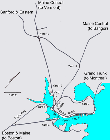
Union Branch split off from the MEC mainline at Park Ave. just past the old Portland Union Station site, where its bridge overpass is still intact and the first 3/4 mile of track to the Forest Ave. exit off 295 is still intact (not even any vegetation overgrowth to belie its 25 years of disuse). After Forest Ave. it slipped onto a side reservation for a few blocks along Kennebec St. (Google shows the northerly sidewalk as being distortedly over-buffered) then passed between buildings onto the alignment of the current Bayside Trail where it fed into "Yard 7", the old CN yard spanning Loring Memorial Park and the sewage treatment plant that also had a track connection to the Grand Trunk main right before the swing bridge. PTC would basically spend all its days making big circles between Commercial St. and the Union Branch shuffling loads between all these yards plus the ones out in the suburbs.


Now...MEDOT has long desired to widen 11 miles of 295 to 6 lanes between Scarborough split with I-95 and Falmouth Spur in Falmouth. It's been *close* but no cigar on funding for 2 decades now, such that it's going to take a leap-of-faith overpay risk to start the ball rolling. But the extra lane capacity is legit needed the way Portland is growing, and would largely be done on the same land footprint by eating the center median. So as add-a-lanes go it's not an induced demand trap and is a sensible greenlight if budgets weren't so statewide tight. Now, the fact that the tracked fragment of Union Branch and active-but-disused Grand Trunk main are in near-eyeshot of the highway through the whole of the add-a-lane project area presents a potentially juicy multimodal opportunity to goose the project's top-line value proposition and make the funding push more palatable. If you reconnected the stet Union Branch west of Forest Ave. the highway rebuild between Forest Ave. and the 1.3 miles to Back Cove presents an opportunity to lay virgin track by the side of the highway, send it across the cove on a widened 295 bridge (bypassing the burned Grand Trunk swing bridge), then hook into the Grand Trunk main @ Kensington St. a few track feet past the baked beans factory. Downeaster + freight main relocate off the MEC alignment onto this new 295 + Grand Trunk alignment out to Yarmouth Jct. Downeaster bangs a right @ Yarmouth towards Freeport on the existing out-of-service east wye, while PAR freights go straight and rejoin their main to Waterville @ Danville Jct. in Auburn. A new Portland Union Station gets sited somewhere within a few blocks of the old Union Station's Congress St. site. Downeaster's reverse move at Thompson's Point goes away forever at tangible schedule gains, and future Portland-area commuter rail can wye its way onto most any alignment from New Union Station.


This isn't even a "Crazy" pitch because so much of the ROW is already available via existing on-the-ground Grand Trunk + Union Branch track or the existing grass median bordering 295's southerly side to the cove. The remaining touches that would tie the corridor together are all taken care of with the highway widening: (1) widened cove bridge with rail berth, (2) compacting of Forest Ave. cloverleaf ramps into a diamond interchange so tracks have straightened shot, (3) new rail overpasses of Forest Ave., Preble St., and Franklin St. adjacent to the rebuilt 295 overpasses. Not much cost increase at all over the solo highway widening project, but would seriously increase its overall upside. Consider the current MEC main has 14 grade crossings inside City of Portland, with 11 coming on 1.9 miles of very dense residential between ME 25 and ME 100. Relocation via 295 to the Grand Trunk alignment whacks 13 out of 14 city crossings. A perfect 14-for-14 if elevating tracks over Congress St. is done in package with this job. Lots of schedule gains to be had there, and huge quality-of-life gains for all that residential. Where, BTW, PAR does transport daily HAZMAT freights through that cluster of 11 crossings. Relocate the passenger & freight mains and the MEC track gets busted down to being used once or twice a week for freight locals to the Bishop St. vicinity, plus once-in-blue-moon alt routings home from Yarmouth Jct. Maybe someday high-frequency circumferential Portland CR can make new use of that alignment with stop spacing dense enough to give something back to the residents around the crossings. 17 miles of redundant PAR main between Royal Jct. and Danville Jct. out in the forest can then be abandoned now that they've switched over to the parallel Grand Trunk alignment between Yarmouth-Danville; Portland will get its closest-proximity 'good' rail trail hike in that exchange.

Additionally, relocating the whole works to the GT main opens up great potential for a Falmouth infill stop on the Downeaster. And you can possibly lay down a wye by the sewage treatment plant to take back the Narrow Gauge Museum track for a 1.5 mile Ferry Terminal stub station that can be served via reverse move on certain Portland-terminating DE slots and/or seasonal high-demand slots where the reverse-move digression (which the DE is certainly no stranger to) is high-leverage enough to go for. Space is there through the park for that connection. If/when Portland CR happens the Ferry Terminal stop can have its service levels further buffed out by being a secondary inner-city terminal to New Union Station.


If 295 add-a-lane is the main megabucks linchpin driving MEDOT decision-making, these rail extras do not add very much above-and-beyond absolute cost at all. But they enormously enrich the transpo capacity and flexibility for all of Greater Portland to do in a package deal, given all the thru-routing benefits to both passengers & freight alike and all the grade separation gains. Not to mention the big, big upside the re-route gifts to future CR in the form of that New Union Station<-->Grand Trunk<-->Yarmouth Junction<-->MEC<-->New Union Station circumferential route lined head-to-foot with multi-directional wye junctions that can be plugged-and-played from all directions.

Total max-leverage build that will pay back its investment in spades, and pay back the 295 widening orders of magnitude faster. I know NNEPRA has kind of been nipping at the fringes of considering re-routes or finding a way to glom rail onto the 295 project, so mental wavelengths are thinking alike amongst planners. But it would be a game-changer if they just up and presented this as 'THE' vision-thing transpo reboot for the city and bulleted out all the above advantages for the public. Momentum would be self-cresting if it had a concerted public sell job applied to it.
 
Last edited:
FWIW, here's the Portland Terminal Company system map MS Paint-annotated with current trackage status. Landbanked or out-of-service MEDOT tracks in lime green, highways in blue, and the new Downeaster + freight main alignment along 295 overlaid with red stripe. Everything that's outright gone is...gone.

Portland rail.jpg


Direction to Yarmouth Jct. indicated, as that's the converging point of current vs. new alignments. I stuck in the optional track connection to the Ferry Terminal across the park + sewage plant property, re-claiming the Narrow Gauge Museum tracks. The stretch of MEC mainline between the split with the Union Branch and the Bishop St. Industrial Track is where that messy briar patch of 11 bypassed grade crossings all are. New Union Station would go somewhere by old Union Station right before the MEC/Union Branch split. Note that the whole map is slightly askew with due north at upper-right, so rotate the orientation counter-clockwise 45 degrees to match up with Google Maps.

For future Portland CR, Yarmouth Jct. is significant at being the point where a circumferential routing can circuit the MEC main + Grand Trunk main. And there's very good fodder for a Falmouth or downtown Yarmouth infill on the Downeaster via the Grand Trunk routing, where there's virtually nothing worth having on the more sparsely-populated MEC routing for Amtrak purposes between city limits and Yarmouth Jct..

Note that NNEPRA will soon be installing a new northbound wye leg at Mountain Jct. for the Portland Transportation Center spur to make the Downeaster's backup move a little easier. That addition, not depicted on this map, will make Westbrook CR accessible from New Union Station and the Yarmouth 'circuit'. Note also that the Bishop St. Industrial Track used to direct-connect to Westbrook until I-95 construction severed it in the middle. Tracks are overgrown near 95 from the east side, but intact up to the highway. On the west side they're way, way overgrown and intact to Chabot St., removed the last 3000 ft. to 95 but with ROW completely intact to the highway because there used to be freight customers as far as Riverside St. Building a single-track rail overpass of 95 to reconnect the ends is easy, and then you can incorporate Westbrook in the 'circuit' pattern with lots of routing flex. Westbrook alone as currently proposed is a crappy proposition for CR because the bus routes straight out of Thompson Point are simply faster. But it's a very different value proposition altogether if you can cast Westbrook as a 'circuit' flavor that is instead accessible from a variety of routings in and around Portland blended in with a larger array of 'circuiting' patterns. So duly note the mostly-active status of that Bishop St. spur, because you probably need to grab that in order to fashion a more compelling sales pitch for Westbrook service.
 
Last edited:
W
A pitch courtesy of Everett officials: https://www.bostonglobe.com/2020/02...l-gondolas-city-hall-casino-assembly-station/

"We're gonna build a huge gondola line and Wynn's going to pay for it!"

We're in crazy pitches, so let's treat it as such.

I don't hate the idea of a fast-track to the T, but it's not getting built without a bike bridge too. The connection of the rail trails has been a focus for awhile, and this almost connects the Northern strand to downtown.

Wynn wants a T connection, and Everett wants a T connection, and NOBODY is spending Billion$ on an orange line extension. Millennium estimated $100M for the 1.5 mile seaport line, so let's use that as a baseline. Would a Wynn gondola from Everett Center (maybe ending behind the library?) generate enough ridership to Assembly pay itself (and likely the cost of the $25M footbridge) off?

Would shifting a gondola south a gondola to Sullivan along Broadway generate more ridership?

PS while we're on gondolas- it got buried, but I really liked the proposal somewhere above of a gondola from Back Bay to the convention center. It serves a much different purpose than South station, and would latch much better onto the tourist market.
 
That's going to be a puke-tacular ride midwinter when the Angry Atlantic is blowing a gale through the inner Harbor.

I mean, if we're going to play this "I ain't paying for it anyway so let's make it whimsical" game could we at least constrain the semi-reality to be region-appropriate as a baseline.
 
I mean, if we're going to play this "I ain't paying for it anyway so let's make it whimsical" game could we at least constrain the semi-reality to be region-appropriate as a baseline.

First off, we don't need an engineering study in this thread- that's why it exists. Plus - this is not only a primary transportation mode but a tourist attraction, and has different values on top of baseline economics. A new bus lane might be far more effective, isn't going to generate any excitement. Don't forget that Wynn paid more for the Popeye statue ($28 Million!!!) than the cost of the proposed bike bridge.

This application is not that far out of the box, and Everett is looking to capitalize on some serious new revenue opportunities generated by the casino's existence. I hate to look to the Roosevelt Island tram for a positive... but "the Tram can operate in all weather conditions except for lightning and winds over 50 miles per hour."
 

Back
Top