Crazy Transit Pitches

Last edited:
As always, thank you for the insight and in depth analysis. Do you have any idea what the types signify in the MassDOT arcGIS Rail Inventory? IE, Northampton is Type 7, Highland(Redstone Trail/armory branch) is type 3, Type 3 being the same as the Watertown Branch and Type 7 the Minuteman.

No idea. I'm mousing over and back-tracing to what these used to correspond to on the old PDF maps, and YIKES! is this in rough shape. The PDF maps were similarly sourced with GIS data dumps...and were so completist they were a goddamn mess for parsing accuracy beyond the map colors that were active or MassDOT/T-landbanked. Many outright errors, and a lot of un-cleaned up old topo maps of things that no longer existed in non-encroached form. But at least it was human-parseable. This appears to be the same source GIS dump-a-thon...but with far less organization than the PDF map.

Best guesses. . .

  • Type 1 = active lines. Doesn't differentiate by owner like the old PDF map used to (which also distinguished between T ownership, MassDOT mothership ownership, and municipal ownership)
  • Type 2 = ???. (Yet to find one example of it on map)
  • Type 3 = Abandoned/extinguished??? These strongly correspond to the old topo line dumps on the PDF map, ancient-abandonments that may or may not still exist in unencroached pieces but definitely have lapsed property lines. They were neat to look at on the PDF map...but even when trailed were kind of useless to Crazy Pitch around because the charter was definitely gone and properties reverted (even when ultimately repackaged or re-stitched by easement for trails).
    • No idea why the very much active freight siding of state-owned Adams Branch to massive Zylonite Quarry shows as Type 3. That's served multiple days a week by PAS, and Google shows the siding loaded full of cars. Makes no sense...map error???
    • No idea why MBTA-owned Manchester & Lawrence is a 3. T-owned since '76, freight rights extinguished '08...went through a proper STB filing in '08 to settle the paper abandonment and do the trail lease.
  • Type 4 = ??? No clue.
    • See it appear both on active/state-owned portion of Adams Branch, but also on most recent state acquisition/landbank of Pittsfield portion that was processed open-shut by the STB in 2016. Active should be Type 1, formal landbank a 7...so ???.
    • Appears on Westover Branch that PAR sold direct to City of Chicopee for the trail as blocking move from MassDOT buy + rights to Pioneer Valley. That was a messy one; could be placeholder???
    • Appears on Quabbin Reservoir-submerged portion of B&A Athol Branch. PDF map correctly ID'd ownership as Mass Water Resources Authority, but the ROW has literally been underwater for 85 years.
    • Appears on Cheshire Branch ('84 abandonment in MA, post-'86 processed in NH) to Ashburnham cluster and over NH border to Keene. PDF map showed that as municipal-owned. NHDOT portion is definitely proper-landbanked. Doesn't appear they know true status one way or the other.
    • Appears on MBTA-owned Greenville Branch on '82-abandoned Townsend portion. This should be a landbank because it was '76 B&M-to-state dispersal and the only thing extinguished was the freight trackage right, but since the '76 deal indemnified B&M with "perpetual" squatter's rights maybe it's not a Type 7 because if (unlikely) reactivated PAR or successors would have first-refusal rights and it wouldn't be open-bid? I'm confused here.
    • Salem & Lowell ROW is a mishmash of 3's & 4's in North Reading and Wilmington, while Google Maps doesn't segment the property lines that wildly. No clue what's going on there.
    • Eastern Route from NH border...but the Amesbury Branch is a Type 7? Huh??? State doesn't own Amesbury, has owned mainline since '76...abandonment from Seabrook-poke was post '76. Really, really makes no sense. That's a proper "proto-landbank" unless PAR perpetual rights are in-play (in which case it's still a landbank), and doesn't explain the Amesbury Branch at all.
    • East Boston Branch trailed portion was a 90's proper-landbank.
  • Type 5 = Abandoned/extinguished?
    • See it on a siding cluster in Cheshire that's not part of the "Type 7" P&NA landbank, and never used to appear on the old PDF map with the topo dumps. Not sure what's different here vs. Type 3.
    • Also on an ancient siding cluster around Chicopee that's never been seen before. Maybe these are "new-find" Type 3's that weren't part of the old PDF's topo-dump dataset???
  • Type 6 = Out-of-service???
    • Seen on Lowell Industrial Track abandoned by PAR 2008, open-docket for 12 yrs. for stalled sale negotiations (Bruce Freeman Lowell extension). In the feds' eyes this is still an "out-of-service" active RR because the docket never closed.
    • See it on active/state-owned portion of Adams Branch. (WTF???)
    • Portion of Westover Branch closest to the base. (Military-owned and not part of PAR abandonment...poss. still a disconnected "out-of-service"???)
    • Out-of-service Pioneer Valley portion of Easthampton Branch that's abandoned but held open for ~20 years for the towns to fundraise to buy for trail conversion (poss. still-open STB docket???).
    • Woburn Loop Industrial Track. (Has only been OOS by service bulletin for 1 year and has new customer permitting to move in...I'd call that "active" if they're calling the 11-years unused Medford Branch "active".)
  • Type 7 = formal landbank. Seems to corresponds (mostly...with some oddities like Amesbury and some weird omissions) with old PDF map color for post-'86 fed-blessed landbanks and court-blessed "proto-landbanks" from the '73 Penn Central/'76 B&M asset dumps and pre-'86 Conrail dispersals.
    • Chatham Branch on Cape was def not a landbank like the "proto-" banking of the Cape Main to Wellfleet. Branchline gone by 1937, preserved by power lines, stitch job for trail.
  • Type 8 = unclassified???
    • Appears on old 1920's-abandon "Huckleberry Line" trolley interurban that the Pike's Berkshire County grading partially ate. Map error on the old PDF maps because that was never on the RR network. I guess they still aren't scrubbing errors from the dataset.
    • Appears on diverted portion of Central Mass flooded by Quabbin Reservoir.
  • Type 9 = ???
    • Only appears on the Lowell Canal ex- industrial trackage now owned by city and partially used by streetcar.

I dunno...it's a goddamn mess. More of a mess than the old PDF map datasets...and those were a pretty thorough mess.

What the PDF map did a lot better was color-coding who owned what, and also shape-coding what was active vs. out-of-service/non-abandoned vs. landbanked/unused vs. active-trailed vs. power line ROW vs. unknown. Which made parsing down way easier than this map.


Amongst lines we've talked about last few posts:
  • Armory Branch -- Type 3. Makes sense for the notoriously ownership-lapsed MA portion, but the CT potion is active. Wouldn't expect accuracy for border-crossers, but CT's a def Type 1.
  • Easthampton/Mt. Tom -- Type 7. Northerly part of the Easthampton Br. fell in the hands of a power company. Mt. Tom was definitely a pre-'86 hatchet job. These are inconsistencies from the usual Type 7 designation and are definitely different from what the PDF map showed in color- and shape-coding.
  • Wheelwright Br. -- Shows as Type 7. This was a confirmed pre-'86 hatchet job. The old PDF color-marked it as lapsed (so...Type 3?) but shape-marked as trail...which would be the closest actual match to lapsed charter + DCR stitch job. I wouldn't trust this one at all.
  • Conn River (MA border to Brattleboro severed by 70's bridge collapse) -- Shows as Type 6, but NHDOT properly landbanked it as part of Ashuelot Branch and depicts as such on their State Rail Map. (Wouldn't expect 100% accuracy from MassDOT for border-crossers.)
 
Last edited:
No idea. I'm mousing over and back-tracing to what these used to correspond to on the old PDF maps, and YIKES! is this in rough shape. The PDF maps were similarly sourced with GIS data dumps...and were so completist they were a goddamn mess for parsing accuracy beyond the map colors that were active or MassDOT/T-landbanked. Many outright errors, and a lot of un-cleaned up old topo maps of things that no longer existed in non-encroached form. But at least it was human-parseable. This appears to be the same source GIS dump-a-thon...but with far less organization than the PDF map.

I edited in another available, color coded version, albeit also without a key. Also, the first one, if you tab over to data, shows the ownership, operator (pax, freight, historical), and other unparsable detail.
 
I edited in another available, color coded version, albeit also without a key. Also, the first one, if you tab over to data, shows the ownership, operator (pax, freight, historical), and other unparsable detail.

Yeah...I'm scrolling through that. Whoo-boy is this a mess. So many field blanks and "??" placeholders. This needs a flashing-yellow caution sign for unvetted accuracy.

I mean...comprehensiveness-wise this is the broadest data dump I've ever seen a state maintain in their GIS files. So the starting point is good. But there's been absolutely no parsing for errors and gappage whatsoever, just a raw data firehose. You can't make a human-comprehensible map of this except in the broadest, softest-focus sense because it's not edited at all. Not even to the degree the published GIS-dump PDF maps affixed accurate color codes for MBTA & MassDOT ownership so you at least knew if you saw a trail or abandonment in those colors it was a vetted-accurate landbank and not the anything-goes of an unknown-status generic color from a topo dump or a residual-B&M/PAR color line that had un-updated current status (e.g. the post-'76es/pre-'86es where a RR.net thread Q&A inquiry would usually backfill the story). For finding definitive answers you at least knew your starting points that way. This is just staring straight into the abyss.

I'd feel great about the enormity of the data if MassDOT were making any effort to manicure it. But they're not. As they've stripped away all the presentation aids that used to go in the PDF map, it's a large step backwards from before on navigability.


FWIW...you'd have to go into the Wayback Machine to find the most recent PDF maps, because they've destroyed all of them except for the dumbed-down one showing just active lines. The last couple years' versions ('16-18) turned off the data layers for the unvetted topo dumps IIRC, so you had to have a full version of Acrobat and pull up the data-layer pane and re-check the layers to "on"(oh, everything you see on the GIS data columns was in there alright...if you knew how to extract the PDF data layer you could auto-build your own Google Earth file straight from the CSV export). The maps from 2012-15 thereabouts were more detailed and rendered in nicer-to-read map skinning...only difference being some of the big CSX-to-state line sales from '08-12 like the outer Worcester Line hadn't changed ownership colors yet.
 
Anyway...if you want to rank the worst "bad behavior" Guilford abandonments that still sting to this day, the list probably goes:
  • Armory Branch -- #1 with a bullet because of how it fucks with all manner of Springfield Line strategery and overtly fucks over ConnDOT who screamed at their MA counterparts for 30 years to preserve at all cost only to get a shrug and an "Our bad" in return. This one may never be totally closed because rail-with-trail is easily accomodated and if future freight industry shifts prioritize locating a big intermodal yard in Hartford/East Hartford or New Haven this is the route that gets bullseyed and a lot of very rich players will be greasing enough pols' skids to buy off Springfield and Longmeadow. But that's a lot of if's. In the meantime....fuuuuuuuuuuck, what a rinky-dink one to let slip. 😩
  • Westover Industrial Track -- pulled the rug out from a half-dozen active (if not necessarily all active car-receiving) signees over "track conditions" bullshit in early-2000's, then played Chicopee and NIMBY-trojan trail lobby to scare the state away from getting dinged with paper cuts in a buy attempt. Pioneer Valley was screaming "TAKE MY MONEY!" at the chance to self-operate the branch, and the state wanted to help them before the alliance they were up against made it too much of a chore. Should've stuck to their guns, as this was an open-docket post-'86 STB case. Oh, and the trail...THE FUCKIN' NIMBY's NEVER BUILT IT! 🤬

  • Pittsfield & North Adams -- Newly profitable B&M bought its way from Conrail dispersals into CT with much fanfare in '82...the company's first 20th century territorial expansion. Armory Branch, Griffins Branch (Hartford-Bloomfield), Highland Line + Waterbury-Derby on Metro North, Torrington, Canal Line Avon-Cheshire, and North Adams-North Caanan via the P&NA + northern Berkshire Line (Conrail retained New Milford-south and the midsection was out-of-service). Sank a shitload of renewed track into their acquisitions. Then Guilford comes in a year later and starts bludgeoning things immediately...Armory chop '85, withdrawal from Hartford a year later (followed by 10+ years of the HFD-Bradley light rail conversion study on the OOS Griffins). Same "track conditions" bullshit customer contract cancellation move on the Canal and Torrington early-90's. ConnDOT saved Torrington by installing the rail museum as freight operator (Naugatuck RR) and shortline-recruiting for Hartford.
But the most sudden drop was the '92 decision to ASAP pull out of North Caanan, where there was big quarry business and barely enough time for the states to react. Housatonic RR, then an all-volunteer excursion carrier that had reactivated the New Milford-North Caanan midsection...showed up with a bunch of suspiciously recent-former Guilford execs newly hired as their V.P.'s and got a sweetheart deal to take over Pittsfield-North Caanan ownership in Guilford's fed filings. That's the same Housy that today is New England's most perenially safety-negligent shortline...but they have such a permissive deal right now they're almost impossible to get rid of (and indeed MassDOT had to pay way more than the Berkshire Line is worth to even get the top-level ownership protection). P&NA midsection had nowhere to go, and was immediately abandoned with MassDOT grabbing the landbank. Had the state been able to participate in a full vetting for Housy's would-recruitment they could've made a claim to the feds for whole-corridor preservation to North Adams: either resource-poor Housy had to pony up for the whole thing, or Guilford had to cut much richer Vermont Rail System trackage rights to come 20 miles down from Hoosick Jct., NY so they could take it over (and get a mucho-lucrative Conrail interchange in the process that Guilford wanted no part of). Didn't work. Guilford gamed the system by striking too fast and having the sock-puppet replacement too quickly. We've been paying for Housatonic's sins ever since while the P&NA is the annoying missing link at making that Albany-poke Pittsfield passenger train *really* cook by throwing North Adams in the deal and having thru-routing capability on PAS to the the joint NY/VT Amtrak Study Corridor from Bennington-Rutland.​
  • Mt. Tom/Easthampton -- Because Pioneer Valley would've had a way higher-capacity interchange that way, instead of the claustrophobic street-running shove moves they have to do for PAS in downtown Holyoke. Also would've made Westfield-Mt. Tom a complete circuit for semi-intriguing passenger Crazy Transit Pitching (thru-run to Northampton? Springfield Loop?). One of the "Fuck you" moves the '86 ICC reauth was designed to prevent...so a victim of bad timing.

  • Keene & Winchendon clusters (Cheshire Branch, Ashuelot Branch, etc.) -- Keene, NH used to be one of the largest rail hubs in all of New England with diverging routes in FOUR directions. Cheshire Branch: Conn River Line @ Bellows Falls, VT to Fitchburg Line twin forks @ Winchendon, MA for Ashburnham/Fitchburg or Gardner/Worcester directions. Ashuelot Branch: from Conn River @ MA state line (later...backup move from Brattleboro after the bridge washed out and mainline traffic was moved to the Central Vermont side). East to NH Main in Nashua via Pererborough and the active Hillsborough Branch @ Lyndonborough, with branch to Ayer. Now Keene is 25 miles from the nearest rail line and is thoroughly sentenced to "forgotten New Hampshire" economic stagnation.
For few years before the Guilford sale B&M had sublet some territory to Green Mountain RR (Rutland-Bellows Falls). GMRR is now part of the big Vermont Rail System and a big cross-state cog in the "Canadian Gateway" lane for delivering goods from Canadian Pacific on the upstate NY Adirondack Corridor to Worcester via alliancing @ Bellows Falls. Their main yard is still on the Walpole, NH side of the river from Bellows Falls on a short active stub of Cheshire Branch. They picked up the yard from B&M in the 70's, and picked up outsource rights to the mills in Keene on the Ashuelot Branch. Their goal was to save up to buy the out-of-service portions of Cheshire Branch Walpole-Keene and Keene-MA state line that were held in suspended animation by the B&M bankruptcy court, reactivate them and trade off the more distant Ashuelot Branch, and get their mainline extended on a total thru route to the Fitchburg Line in MA. That would've been killer today...because if they had cobbled together rights into Gardner via Winchendon VRS today would have a mucho lucrative lane straight into Worcester, and if they had cobbled together rights into East Fitchburg Yard via Ashburnham Conrail probably would've never mothballed the last 5 miles of the Fitchburg Secondary from downtown Leominster because of that net-gain interchange.​
When Guilford came in they were having none of this rent-to-own stuff with a potential competitor, immediately canceling the outsource deal and taking back Ashuelot Branch ops themselves. Self-ops lasted exactly 1 year before they pulled the rug out and mass-abandoned everything to salt the earth...including the active Winchendon cluster so GMRR had a shredded map in MA even if they prevailed in NH. Town of Winchendon bought all ROW's, though being pre-'86 it's "Thar be dragons" whether they remembered to scoop up the charter or just bagged the land. The mess in NH was fought long enough to stretch post-'86, so NHDOT sewed everything up under full landbank. But GMRR never had a chance to plead its case, so something big was lost. Today the Cheshire Branch Ashburnham-Bellows Falls is semi-intriguing as a far less-shitty North Station-Montreal route than the (inexplicably) VTrans-studied and fed-eyeballed Northern out of Concord. One where you could still throw a couple peanuts the Capitol Corridor's way by running it via Lowell for an RUR transfer, then down the Stony Brook Branch for Fitchburg and on-alignment to Bellows Falls. And VRS would absolutely sign on for freight co-rights today to get into MA, something no one would ever do on the much shittier Northern. Of course, that's still a Crazy Pitch because the Springfield Hub/NNEIRI proposal is barely any different on schedule and blows all cross-NH routes out of the water on ridership and cost-effectiveness thanks to South Station + Worcester + Springfield/CT and cross-tix chaining opps @ SPG Hub. But at least as Crazy Pitches go Cheshire Branch >>> Northern Route and *almost* as well-landbanked (insofar as Winchendon's way too small to be an interference concern if statewide build priorities ever favor it).​


I wouldn't rate the Wheelwright Branch as a consequential loss, because the Conn River and Central VT are already connected a scant few miles upstream @ Deerfield by the huge yard connector and that branch truly was D-U-N done when the last business on the Northampton-Amherst section closed so nobody (not CN from the Central VT, not Pioneer Valley coming way out of range from Holyoke/Easthampton) was ever going to touch it. Guilford did non-assholishly sell the other Bondsville-Ware segment to Mass Central RR (who run Palmer-Barre on the MassDOT Ware Secondary) as a branch to Downtown Bondsville until that biz dried up by 2000. There's still tracks on most of that segment. CN (now NECR) took the Central VT-side junction of that segment for an industrial park siding. The 1.1 mi. Bondsville NECR siding is unbelievably the very last active remnant of the once- 99 mile Central Mass mainline.
 
Last edited:
Shouldnt all this be in a Guilford or NE rail thread?
 
Shouldnt all this be in a Guilford or NE rail thread?
My bad! In our defense, it all started with a pitch, on the previous page, which I put here to avoid derailing the NE rail thread. It snowballed after research into extant (or not, or just plain unclear) RoW and associated legal proceedings and charter rights to effectuate said pitch, whereby I got F-Line's estimable attention and volubility.

It may be worth moving/copying the constituent parts to the appropriate sub threads, but I leave that decision in your good hands.
 
Ruling this as "Crazy" and not "God" pitch on these grounds:
Acquire right-of-way to Bradley Field, Windsor and Windsor Locks

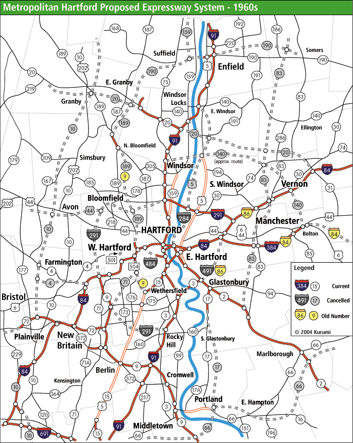
OK...so as I remember vividly from my youth in CT, ConnDOT once studied (into the ground) making a light rail circulator between Hartford Union Station and Bradley Airport using the ROW of the Griffins Secondary freight line to Bloomfield and some TBD acquisitions of power line company ROW to the Bradley Airport terminals. Stops would've served Hartford's dense north end, University of Hartford campus, Route 218 Bloomfield, Downtown Bloomfield, and the Day Hill business park by CT 187 before crossing the Farmington River and going to the Airport. Two-time incarcerated federal inmate Gov. Rowland turfed the LRT study immediately upon taking office just as the torturous debate was hitting the Legislature about funding, replacing it with a tankapalooza busway study (Rowly did lots of busway studies...his underpants were also ripe with the smell of payola from private bus companies and BRT astroturfers, so there wasn't a ROW he didn't blow money paper-studying buses on).

In the years since 1995 the Griffins Secondary went from an out-of-service Guilford/Pan Am dispersal back to a quite busy freight branch again under the tutelage of homeless-man's shortline Central New England RR (basically the one-man brainchild of owner A.J. Beliveau, who squeezed blood from stone to revive both the west-of-river Griffins and east-of-river Armory Branch from the dead on shoestring budget). LRT not really an option anymore because of the revived freight activity. The Hartford Line was born into a more modern era, now New England's most bullish growth prospect as it slow-cooks to more RUR-like featuring. And Rowland went to prison not once but twice. Because majority of the ROW from end-of-track on the Griffins to East Granby is under sole-owner lock and key of Connecticut Light & Power (with a FAT median and nicely-graded access road through the middle ripe for reappropriation), ConnDOT keeps a toehold on acquisition of that property by earmarking it in the tertiary/miscellany priorities of every State Rail Plan revision (as you can see from PDF page linky above). Current valuation is $3M for the buy-to-landbank from CL&P.

They're still--haplessly--studying Bradley Airport rail options. And as you can see from the linked study (reading optional)...not really getting too far with that. Various floated proposals for a Bradley Branch dinky have gone nowhere, mainly because as a shuttle routing it doesn't beat a straight bus from the upcoming relocated Windsor Locks Depot to be worth spending any money on. They're not keen on reviving the Griffins plan out of trauma for how bitterly that ended in the mid-90's and because it's "big" thinking. The rest of the study schemes are just throwing shit at the wall in desperation that they want something rail-branded™ to the airport Terminal but don't want to pay a lot for it, and have read too many warning posts in the online Transpo Intelligencia that mainline rail airport connectors are heinously overrated.


In short...ConnDOT needs a swift kick in the pants to get its head around this. Presenting: Griffins Urban Rail.

Griffins.jpg


Basically the routing repeat of the Major Investment Study, but done as mainline RR mode because of the active freight. This is a dense-stop EMU service primarily drawing from Bloomfield-in and cast in contrast to the paralleling Hartford Line for the short-haul density hugging the North End neighborhood alignment vs. the sparser/faster river alignment. Run 15 mins. frequent with *short* consists. And work the bus connections to the hilt, because the density mix is perfect for that with all the thick residential, UHart, and the business parks. The Griffins unfortunately has a shitload of grade crossings, but by keeping to the short-sets/dense-spacing motif it makes appropriate use of the infrastructure without overtaxing itself.

The CL&P ROW conversion is pretty cut-and-dried...just a new bridge passing over CT 189 + Farmington River, then straight-up regrade CL&P's gravel access road. Bonus by giving freight service to the very large East Granby trap rock quarry as a kingmaker sign-on for Central New England. That quarry pumps a lot of big truck traffic onto the local roads reaching back to CT 20/I-91. ROW between Hatchet Hill Rd. and Bradley is speculative, mostly splitting property lines. There are not enough total abutters here to cause any NIMBY problems, and the Griffins LRT MIS investigated that to death. All state land once you hit CT 20 (and actually some of the warehouses on International Drive immediately prior are on state-managed land catering to the airport). The actual Bradley Terminal station would front Schoepester Rd. in front of the long-term parking garage on semi-elevated structure for grade separation of the various lot driveways. There'd have to be a freight passing track here solely for managing freights' slowness around the adjacent sharp curves without fouling pax trains at the station stop. Service can either terminate at Windsor Locks on the Springfield Line or 'circuit' back to Hartford.

That's the base build. The most recent Bradley study's pooh-poohing of lack of Springfield-facing access made no sense when the grading is right there for adding a wye leg to the Springfield Line straight off the CT River Bridge onto the Bradley Branch. Depicted on the map accordingly. The Bradley Branch makes its distended 'hump' into Suffield nothingness because it was originally built as a fork off the Suffield Branch, which was abandoned in 2008 from the top of the 'hump' to Suffield Depot. There's straightening potential by cutting across the woods and a bunch of tobacco field property lines straight from the National Guard camp to the industrial park on CT 159 bypassing an empty 2.5 miles' worth of the 'hump'. It's about 1.2 miles worth of savings and a lot more straightness. I don't think that shortcut's anywhere near a high-leverage 'get', however, unless you run into an unusually smooth negotiation with the abutting landowners. The existing alignment looks fugly on a map, but does the job.


Accomplishments: traces a whole useful-unto-itself transit corridor with rich routing options. Fixes main flaw of back-and-forth 90's Griffins LRT terminating at the Airport with no 'circuit' ability or Springfield routing utility. Fixes the haplessness of the Windsor Locks-side Airport dinky offers no above-and-beyonds over the shuttle bus. Griffins corridor at-large is a pitch perfect case study for Urban Rail :15 utilization at dense stop spacing to dense environs. But the marriage with the airport is the critical-mass kick in the pants, differentiating it from the overrated "airport dinky" dreck. Despite the new-ROW mileage involved, half of the virgin routing being $3M cut-rate land buy from an amenable CL&P starts things off on very good footing and using the incumbent RR mode with its freight biz underwriting will take away a lot of the price shock the state struggled with when it was over-debating the original LRT option. Electrification doable on the whole length for 1 substation's cost, short sets and no Amtrak keeping the juice requirements on the low side. Obviously can also use this as a rainy-day Springfield Line pax bypass in the event of something catastrophic like an overtopped Connecticut River flooding the tracks (it happens).

Furthermore, the Springfield Line's in a little bit of a pickle for thru freight because of MassDOT's brain fart at attempting any preservation of the lapsed Armory Branch ROW in Longmeadow and Springfield. That's the high-and-wide route if you ever need to get intermodal down to Hartford/New Haven after the Springfield Line is electrified...so the (not totally fait-accompli, but mostly) loss hurts. A completely connected Griffins to Windsor Locks can recover *most* of MA's Armory brainfart by permitting high-and-wide alt routings from Hartford to Enfield, where points north the Springfield Line only has 3 overhead bridges the rest of the way to Springfield to treat with undercuts or unpowered passing tracks. The Griffins, owing to its status as somewhat of a grade crossing minefield, only has 4 overhead structures its entire active length, all of which can be very easily undercut for wires-over-freights. Bradley Branch has zero. CL&P ROW has zero. East Granby-Airport TBD connecting leg most likely has zero. Yep...ConnDOT will still rightly hold a grudge at MassDOT for pissing away the Armory connection, but there's an ace fumble recovery for you right there.


Throw this in the mix with HFD-Naugatuck Valley CR, some poke to Manchester that hopefully has shotgunning opportunities for reanimated Willimantic (then New London) connection with NEC FUTURE's help, and ever-diversifying Hartford Line layer cake and the Hartford Union network is really cooking with gas.
 
Last edited:
Okay, BLX-Lynn on the Point-of-Pines alignment...but instead of building a new bridge across the western channel we beef up the supports of the North Shore Road bridge...and run an elevated over it.

Blue would run at-grade until just after Point-of-Pines luxury rentals. Then, it would climb up on an incline that would take it over the Lynway/North Shore Road access ramps. The structure would keep climbing until fully over the North Shore Road, and follow it across the Western Channel.

From there, the structure would s-curve to join the Eastern Route at River Works, then descend to grade level for the remainder of the trip to Lynn station.

Any criticism?
 
Last edited:
Yeah, PoP ROW has been built over. It doesn't exist. And even if it did it runs so close to homes that it would be opposed.
 
Yeah, PoP ROW has been built over. It doesn't exist. And even if it did it runs so close to homes that it would be opposed.

No...it's pretty firmly verified that the ROW hasn't been built over. It's been built around to within an inch of its clearance envelope by the apartments near Carey Circle--and that is annoying--but not encroached because the ROW-proper is still hosting power lines even through there. State still confirms it as a viable Alt., though YMMV on degree-of-difficulty.

Okay, BLX-Lynn on the Point-of-Pines alignment...but instead of building a new bridge across the western channel we beef up the supports of the North Shore Road bridge...and run an elevated over it.

Blue would run at-grade until just after Point-of-Pines luxury rentals. Then, it would climb up on an incline that would take it over the Lynway/North Shore Road access ramps. The structure would keep climbing until fully over the North Shore Road, and follow it across the Western Channel.

From there, the structure would s-curve to join the Eastern Route at River Works, then descend to grade level for the remainder of the trip to Lynn station.

Any criticism?

Can't do it on 1A because that's a drawbridge...and an older one at that so retrofitting is out of the question.

Crossing the river isn't a big challenge because you won't be duplicating efforts with a wholly separate bridge across the main channel in remake of the old BRB&L Bridge (remnants of it repurposed into the pipeline crossing next to 1A). There was another former rail line here, the very short-lived Boston & Maine Revere Beach Branch that tried unsuccessfully to direct-compete with the BRB&L. The B&M (before it acquired the Eastern RR) used to come in via Saugus Branch and short-hop trackage rights on the Eastern over Saugus Draw, then fork off on its own short 500 ft. crossing of the Pines River channel before running on top of the literal Revere Beach boardwalk. Bent back onto the Eastern around Wonderland (still sorta traceable by the border of the Logan lot). It lasted less than 20 years before being ripped out. Hardly anything remains of it except for the very readily visible junction and rock causeway abutting the Revere side of Saugus Draw, where it currently acts as a service dirt road for 2 power line towers. B&M alignment continues on the PoP side as the property border between the marina and Gibson Park.

The B&M alignment is what you recycle to do the crossing. Some light rework of the 1A ramp spaghetti (which could use it anyway) for coming across, then slip onto the B&M alignment with a rising incline towards a fixed bridge. 500 ft. crossing then follow straight into the visible junction alignment onto a quad-track fixed replacement for Saugus Draw. The Saugus Draw fixed replacement is thus a big deal for saving the duplication of efforts doing the crossing.
 
Last edited:
[Crazy ConnDOT stuff. . .]

Now let's crank this fever up to 11!

CT State Rail Plan, p. 201, re: Armory Branch
Design And Construct Freight Rail Connection – Former Rockville Branch From Broad Brook To East Windsor. $5.8M
You know...I never knew what the hell they were talking about here because the NYNH&H Rockville Branch is the rail trail that starts in Vernon and doesn't go within 6 miles of East Windsor. So the name-check and the price tag made anti- tactical sense for the longest time. Then it dawned on me earlier today while I was doing that Griffins MS Paint job...OH! THE TROLLEY LINE! Connecticut Trolley Museum on CT 140 just a few blocks from I-91 in East Windsor runs on a couple miles of former interurban ROW known as the Hartford & Springfield Railway Rockville Branch. About three-quarters of it is in active, the rest owned but not in use because of a missing Scantic River bridge. Property line just so happens to end at CT 191 a mere 2200 ft. crow-flies from the active Armory Branch by Broad Brook Elementary School.

On the East Windsor end the streetcar yard at CT 140 is 1 mile from the Springfield Line's touchdown on the east side of the river. Ample open land to fashion connections at both ends (albeit tight squeeze on the Broad Brook side). $6M seems appropriate for acquisition of all the grading. As for the trolley museum...well, that's not going anywhere since it's been an institution since 1940. Maybe double-tracking of the currently singled ROW so RR and interurban go side-by-side.


So now...presenting the Crazy Hartford Circuiting Map.

Armory_circuit.jpg


Another one I'd call a "God" move except...there but for the grace of Him/Her it is sitting on p.201 of the State Rail Plan for a crazy-but-mortal verdict.

Depicted above: Griffins/Bradley circuit, southern Armory Branch with trolley ROW pingback to Springfield Line, and first leg of the Manchester Secondary to points Manchesterish shown. Stations are supposed to be numbered/lettered for captioning, but came out way too small. Here's how they list.

0 - HARTFORD UNION STATION
1 - Windsor (Springfield Line)
2 - Windsor Locks (Springfield Line)

3 - Albany St. (Griffins)
4 - University of Hartford (Griffins)
5 - Blue Hills/CT 218 (Griffins)
6 - Bloomfield (Griffins)
7 - Day Hill Business Park (Griffins)
8 - East Granby (Griffins)
9 - Bradley Airport (Griffins)

A - East Hartford Center (Armory/Manchester Sec.)
B - Buckland Hills (Manchester Sec.)
C - Burnham/I-291 (Armory)
D - South Windsor (Armory)
E - Scantic (Armory)
F - Bound Brook (Armory)
G - East Windsor (Armory/trolley)


Both the Griffins and Armory are set up to circuit back to Hartford via the Springfield Line...or, make a grand circuit from each other like a giant I-291'ish radial. Similar to the Griffins, the Armory is a grade crossing minefield (esp. on the long paralleling of US 5) so minimalistically short sets run at Urban Rail frequency are the key for keeping gate timings tolerable.

Yeah, it's crazy...but much like with the Griffins-Bradley buy the appraisal for buying the land to bank ain't pricey in the slightest for the 100-year considerations of reserving the path. Either somebody inside ConnDOT is supremely good at spotting usable tinker toys on a property valuation map. Or Central New England RR owner A.J. Beliveau was a magnificent bastard for getting that footnote buried in the official State Rail Plan on-record with the feds, because now it's unlikely to get scrubbed from any subsequent plans and will probably be footnoted for eternity.
 
Last edited:
I don't know that area very well -- do you think there is demand for 15-minute headways?
 
I don't know that area very well -- do you think there is demand for 15-minute headways?

Griffins Corridor...sure, absolutely. It's a way denser corridor than the Springfield Line along the riverbank cavity. But Griffins was also immaculately studied-out to those service levels in the 1990's LRT plan, so it's got decades of sourcing to show the solidness of the numbers.

Armory got one of two-time encarcerated Gov. Rowland's fake busway studies, but basically all of those except for the serious proposal that begat CTFasTrak were thinly-sourced garbage and aren't archived anywhere by the state. It would obviously need a fresh look. That side of the river is considerably less dense...but it's not un-dense by any means.

If you look at this infamous map of canceled Greater Hartford highways, the Armory and its Springfield Line pingback basically trace out the I-284 corridor...so it's not nothing. (Griffins basically would've ended up on the shoulder of CT 189 to Bradley.)

art-hfd-fwy-60s.png


Honestly don't know why the trolley ROW connection made it into the State Rail Plan as a freight wishlist. Probably covering their asses on linking the Armory to Springfield since MassDOT never listened to them on preserving the Longmeadow-Springfield ROW. It's pretty crazy for a State Rail Plan bullet because it's such a big far-reaching grab for such a small podunk shortline...but not ginormously over-the-moon crazy in absolute terms or the cause of 100-year future-proofing given that the trolley ROW covers the bulk of the pingback and they just have to seek short strips of land protection on both sides of it to reserve all future considerations. But def a bit crazier than the Griffins/CL&P land grab, which is downright sensible and very well-vetted by the 90's LRT plans.
 
Carrying the Griffins extension even further..
If MassDOT continues to be lax in reassembling the Armory line on the Mass. side, what are the prospects of extending the Griffins line another 2 miles along the CLP ROW to the Farmington line, and reactivating that into Westfield to use as the secondary freight bypass of the Springfield line?

*edit*
Derp, that would still require Mass cooperation on the Westfield end.

I doubt there's an intact RR charter even though the land is under Southwick + Westfield municipal ownership the whole way, because that abandonment landed in the squishy 80's era. Conrail pulled out of the Canal Line all points north of Avon, CT in '79 and gave ConnDOT the same right-of-first-refusal "proto"-landbanking deal that Conrail was giving MassDOT for its feds-owned era early abandonments. So ConnDOT has everything properly landbanked to the state line. In MA, however, abandonment was delayed to allow shortline investors to buy up the lines...which begat Pioneer Valley RR in '82 (still very much around in the Westfield-Holyoke cluster). PV retained a short active stump south of the B&A diamond to serve some industrial park customers into the early-90's, but the Southwick portion and southernmost Westfield portion to Southwick town line spanning end of PV ownership and start of ConnDOT ownership lapsed into town hands with a definite charter break. Westfield purchased up to the B&A diamond from PV with a formal landbank, but that's only like 1.5 miles chartered vs. 8 miles of breakage.

Canal's not what you'd call an ace reactivation candidate to begin with since it avoids all density like the plague in Simsbury and Granby on the CT portion, with its only density pockets in Southwick Center and Westfield being well-served by PVTA buses straight to Springfield Union and Hartford Line transfer. Up in the "jigsaw cut" of the CT/MA border they're going to get better transit in the end by MassDOT making a major reinvestment in the RTA's so PVTA can pulse its inner-'burb frequencies to meet densifying Hartford Line service. It's a SPG Hub world being built out there on a foundation of max mobility being achieved via highest-frequency two-seaters.

In fact, the only reason the relatively barren density cavity in East Granby is tolerable for the Griffins-Bradley link-up is because the CL&P land is so bargain-basement cheap and pre-graded for a fast rail jaunt between Day Hill and Bradley. You can see from the Bradley LRT study link a couple posts up of the whole spaghetti map of alignments that they tried...including several other zigzaggy power line ROW's to the east to try to hit a little more density. But "density" is all relative here when it's a few residential cul de sacs + airport-cluster warehouses + still-active tobacco farms; that's simply all there is between the Granby side of the Farmington River and Airportsville. Easiest/fastest build by far still ends up the straight shoot through the woods on that really fat power reservation with the full-graded access road.
 
It's been awhile, so I guess I should throw in another crazy transit pitch: we're bringing the Blue Line to Mattapan!

Screenshot 2020-09-04 at 3.01.08 PM.png


Here's the rationale:
  1. Blue Hill Ave really needs some sort of Rapid Transit, as evidenced by another BRT proposal being floated only a few years after the demise of 28X.
  2. The Red/Blue connector is on the docket, but once you've made that connection it's pretty unclear what to do with the Blue Line from there.
  3. Roxbury was screwed over by the Orange Line relocation, and we should try to restore some real rapid transit service through Nubian Square.
  4. Since the Blue Line cars are shorter and can tolerate more LRT-like geometry, this line is a better fit for the wiggly alignment necessary to get through the city.
Here's the route:

Screenshot 2020-09-04 at 3.02.00 PM.png

  1. Beyond MGH, go under Storrow for an Esplanade stop.
  2. Hook south and break out the TBM under Dartmouth St. This is the (first) expensive bit, since we need to get underneath Copley and Back Bay (if we want to get really crazy, you could try to link Copley and Back Bay with a new Blue Line station under Dartmouth, making a Green/Blue/Orange/CR megastation).
  3. The TBM starts to surface at the Tremont station, and then we have a fun curve southwest to get on Washington St. at the Reynolds Playground.
  4. Now the second expensive bit, cut-and-covering under Washington St. Lots of utility pasta to be relocated and who knows what we'll find in there, but it's the cost of getting to Blue Hill Ave!
  5. Straight shot to Nubian, and then we continue down Warren St. It's pretty wiggly but should be okay for Blue Line cars.
  6. Warren St. empties out into Blue Hill Ave, and from there it's a (relatively) clear shot to Mattpan.
Screenshot 2020-09-04 at 3.02.30 PM.png


Stations:
  • Charles/MGH - Red
  • Esplanade
  • Copley/Back Bay (proposed name: Trinity) - Green/Orange/NEC
  • Tremont
  • Blackstone
  • Mass Ave
  • Melnea Cass
  • Nubian
  • Warren Gardens
  • MLK Jr
  • Grove Hall
  • Franklin Park
  • Harambee Park
  • Morton St
  • Blue Hill Ave - Fairmount Line
  • Mattapan - HSL/Red
Total distance from Bowdoin: 7.6 miles (~1 mile TBM, 6.6 miles C&C)

Downtown map in context with other lines: a side effect is that it creates quasi-loop service downtown with Green and Orange (and CR post-NSRL).
Screenshot 2020-09-04 at 3.44.12 PM.png
 
Last edited:
I gotta hand it to you -- I've seen many Blue Line West proposals over the years, but I don't think I've ever seen one to Nubian/Mattapan via Back Bay!

There is stuff I like here (or at least find thought-provoking).
  • Creates more of a centralized hub at Back Bay, which reinforces it as a "satellite" downtown, both in terms of the city itself, but also in terms of the subway network (relocates transfers, etc)
  • I don't know if there currently is quite demand along Blue Hill for out-and-out HRT, but you have to think this would help boost it
  • The direct heavy-rail link to MGH is a nice bonus, and the Trinity superstation (nice throwback name) would help link Orange and Green, and make for an easier Blue-Green 2-seat journey from Mattapan to Longwood than the more conventional LRT proposals do. (Although I'd note that the current BRT proposals do still basically land you a one-seat ride, albeit with a bit of a walk from Ruggles)
The theoretical downsides, though...:
  • There is such a logical Mattapan-Blue Hill-Nubian-Washington-Downtown corridor with such an obvious path for rail that doing anything else seems, well, crazy (no pun intended). If we want to bring HRT to Nubian, Grove Hall and Mattapan, the more elegant route would be an extension of the Green Line and then convert that to HRT (which isn't as crazy as it first sounds, but I'll save that for another time)
  • That jog over to Back Bay and Charles adds almost a mile to the journey between Nubian and State Street. Yes, it gives you the direct connection to Back Bay Station, but then you wander in the wilderness of the Back Bay and Beacon Hill neighborhoods for a mile until you hit Charles/MGH. (Yes, obviously those neighborhoods are not literal wilderness, but any intermediate station either is in the catchment of an existing station, or has half of its catchment eaten by the river.)
But still! I like the thinking, particularly as it floats the idea of another HRT "trunk" between the Orange and Red Lines.
 
Assuming a RLX to Mattapan would happen before something this ambitious could come about, this seems like a solution looking for a problem. I'm skeptical the capacity demand couldn't be met by just improving bus service and a glx to nubian
 
I think the question to ask is "What's the demand for this routing?"

Mattapan is covered by rapid transit...easily convertible to HRT for the full-on Red Line one-seat. Nubian needs rapid transit, but the easiest reach is LRT'ing Silver Line-Washington with an attachment to the Green Line @ Boylston and then diversifying the link-up options around that spine by implementing Urban Ring south-half BRT. Blue Hill Ave. has the reservation, and its access is strengthened by implementing the LRT spine + Urban Ring BRT radial to Nubian to facilitate easier linked-trips. The extra rapid transit transfer @ BBY is accomplished by relocating the E off Copley Jct. to thru route to the South End/Boylston hookup (which also means you can augment the BRT south Urban Ring with Kenmore-Nubian via Huntington/South End alt patterning on LRT).

So where's the above-and-beyonds for:
1) Extending Blue *partially* under Storrow Drive in a presumed trade-in but bailing out well before Kenmore, which more acutely needs some augmentation, is the easier shot from the Storrow trajectory, and leaves copious TBD future extension options from Kenmore via Brookline Ave. and the B&A ROW.
2) Doubling up Copley/BBY when the E can eventually do that. But as in #1 explicitly passing up Kenmore to multi-stack transfers here instead. Assuming the E is still a candidate for relocation does BBY really need the luxury of a three-line mashup?
3) Engaging the tunneling expense under Washington without quantifying whether LRT conversion + diversification of Nubian transfer options via Urban Ring adequately addresses demand. Yes...this is a more perfect El-replacement build. But if LRT is roped in with the BRT Ring the transfers will be realigned in useful ways that didn't exist when the El was there...so does that extra linked-trip diversity satisfy the "equal or better" answer the neighborhood's been seeking for 3-1/2 decades? A "more perfect" dig has to quantify its top-line above-and-beyonds vs. its extremely steeper bottom-line costs. Starting with whether the one-seat utility crosstown truly matters when for 120 years Dudley/Nubian has been a transfer & linked-trip nerve center.
4) Ditto...why the width of Blue Hill Ave. mandates a tunnel dig vs. all of the above considerations. Is this a one-seat-to-downtown audience for the money when the Blue Hill corridor has never ever one-seated anywhere (not even in streetcar days when Dudley & Egleston had streetcar-subway thru routes) and has always worked the linked-trip transfers at its Nubian or Mattapan ends. What's different now on the demand side that's screaming for a one-seat, or is this an answer seeking a demand question?


It's not an unworkable build. Expensive, sure, but still moored to Planet Earth. It's just that the demand questions for each of the treated areas already have a well-studied potpurri of transit expansion options that do the job, so this one's got to stake itself to a toothier answer of what's the thru-and-thru demand giving this above-and-beyond bona fides for the extremeness of the expense and duplication of quite a few better-studied plugin options. Especially as it addresses Nubian linked trips, add'l Back Bay coverage when the perma-fix for the E junction checks off that box, and the Storrow-teardown routing at exclusion of Kenmore vs. excess @ BBY. Is there a burning-demand thru corridor here or a collection of coincidences that only line up if this Blue extension is built to the exclusion of a bunch of that other studied potpurri?
 

Back
Top