East Boston Infill and Small Developments

It's definitely a negative, and I admittedly didn't start riding a bike again until after I had moved here 10 years ago (maybe bike access to downtown would've factored into my decision if I had already been biking).

I do think that sometimes too much can be made of the lack of a bike/ped connection though. If you live near Maverick you can be in downtown in one subway stop. And for all but two hours a day you can bring your bike on the T. My guess is that people living in Watertown or Malden (both places I like a lot) are much less likely to find themselves on a bike or on foot in downtown within 15 minutes of leaving their house than I am. Certainly downtown isn't the center of gravity for every activity (Cambridge, Fenway, etc), but other than the late night cab issue (soon to be mitigated by later subway service) Eastie is more convenient to places like the North End, Faneuil Hall, DTX, Financial District, the Common than any other neighborhood that's not in downtown.

This is where I think the barrier is more psychological than physical (as another poster mentioned). Most people in watertown and non-core neighborhoods drive or take the T to work. Biking and walking are still a rarity (especially for the watertown/malden group- I'm not saying its not a plus, but only committed cyclists do that to the point where its a deal breaker).

I think people do focus on the exceptions rather than the rule and that this will change in Eastie. It's the same reason people buy houses with giant extra spaces "for visitors" which may be 2 times a year, when it would be cheaper to just buy people a hotel room.

Eastie is very isolated in the Boston mentality. It's a walking city. When I lived in the North end, I would get up and meander and end up in Fenway. I never went to Eastie. Now I am in Somerville (connectivity to a job in cambridge was primary for me- looking at you red-blue connector!), but if I were downtown it would be close. Rents along the red and orange corridors (to say nothing of the corroding trains) are beginning to push people to consider eastie. In ten years, we will have posts talking about how yuppie coffee shops and fake pizza places are pushing out established institutions and immigrant and workforce housing.
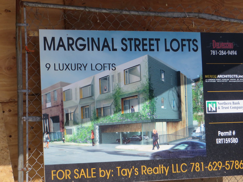
 
That's great that so many people would move to Eastie if there were a bridge. But let's be honest about what that means. Except for some five story luxury condos along the water, Eastie isn't getting a major buildup. You'd be moving into the existing neighborhoods whose current residents will be priced out. The great ethnic restaurants that are there will fast become banks or Paneras.
 
That's great that so many people would move to Eastie if there were a bridge. But let's be honest about what that means. Except for some five story luxury condos along the water, Eastie isn't getting a major buildup. You'd be moving into the existing neighborhoods whose current residents will be priced out. The great ethnic restaurants that are there will fast become banks or Paneras.

Very right. I think a bridge would end up shifting growth and development in roxbury and to eastie. Eastie is limited in how much it will grow, and I could really only see a bridge being worth it if some real high rise density could be added. Adding 10-20k units of real TOD with a 1-3 stop heavy rail trip would make it worth it. Without limitations, it would definitely be Boston's Brooklyn.
 
Is there a dedicated pedestrian/bike bridge across a shipping corridor as long as this supposed NE-EB connector anywhere in the world? If a bridge for cars between downtown and Eastie doesn't cut it (hence the tunnels) what data or study could possibly lead to a pedestrian bridge crossing? It just seems like a non-starter.
 
Is there a dedicated pedestrian/bike bridge across a shipping corridor as long as this supposed NE-EB connector anywhere in the world? If a bridge for cars between downtown and Eastie doesn't cut it (hence the tunnels) what data or study could possibly lead to a pedestrian bridge crossing? It just seems like a non-starter.

Busses -- Exactly

The only way there would be a bridge is if the harbor was declared a non-navigable body of water

This is not happening unless there is another Ice Age and Sea Level drops 30 to 50 m

Then:

you can walk along the bottom of the harbor

Of course before that happens the Boston Harbor will be frozen most of the time and you can walk across the ice

Put this one under Crazy Pedestrian Pitches

The game changer is the relatively easy to do and relatively low-cost pedestrian link between the State and DTX Stations enabling you to walk to Maverick get on the Blue Line and then get off at Aquarium or State directly and from State to walk to DTX for the Red Line and then to Park for the Green Line even before Gov't Center re-opens
 
Its great that some of you guys are living over there and dealing with the situation as it exists now, but I don't think you have any idea how many more people want to live in eastie, but don't because of the lack of a direct pedestrian connection to downtown. I'm one of them. I know so many people who are living in watertown, malden, etc who said they strongly considered eastie, but didn't because of the accessability. The housing stock is great, so is the food, view, and distance from downtown. But not being able to walk or bike makes it a non-starter

Dave -- have you read your own cohorts comments -- If you would walk then walk to Maverick go under the harbor for the price of cup of coffee and get off at Aquarium [take the stairs for extra credit] and then do some additional walking

Aside from the extreme unlikeness of building a bridge -- if you are going to walk over the bridge why can't you walk and take the T

If your argument is that you need to be able to cross back and forth across the harbor between midnight and 5 Am -- you are going to be in a very small minority of all of the people living in East Boston or even potentially living in East Boston
 
Being able to walk anywhere is one of my favorite things about Boston. I frequently walk from Brighton to the north end or chinatown, etc such on a nice day. Not to mention the ability to walk home if stranded somewhere (which I have done more than once). Not being able to do that is a huge disadvantage, too large of one to consider living there.

Now I do think a bridge from maverick to the north end might be excessive, however a bridge from central to chelsea, and from chelsea to charlestown (restored broadway draw bridge) would mitigate it well.
 
I think people are looking at convenience over practicality here. You can walk to East Boston from Boston Proper. You just take Main Street in Charlestown to Broadway in Everett, then walk down RBP to Second Street and take it into Chelsea, walk under the Tobin, and make your way across to Marginal Street.

I would love a tunnel that started at Revere Beach and surfaced just under the Hingham Rotary so I can avoid 90 minutes of traffic when I am coming back from Maine at rush hour. However, like my tunnel idea is a fool's errand, so is a marine traffic blocking bridge.

A pedestrian bridge so people can go to the cheaper rent of East Boston will mean one thing, higher rent. Once everyone goes "It so nice there, and there are all these cute ethnic places, and great housing stock", the place is done. Hence you get JP II or Davis Square, all over again. Then all that "grit" that people salivate for on these posts gets relocated to Lynn, because people could not afford the East Boston rent and the downside of its isolation got pushed out.
 
BRA Say’s Boston’s Part of Greenway Connector Project May See a Delay

At a Friends of the East Boston Greenway meeting last Thursday night, Boston Natural Areas Network Valerie Burns told members that they received word from the Boston Redevelopment Authority that there have been some delays on the Boston end of the project that will run from the end of the Massport section from Short Street to Constitution Beach. The Massport section of the connector will run from the Bremen Street Park to Short Street.

The BRA’s Melina Schuler explained that the Boston section of connector is complicated because it is a multi-agency project that involves the city to get easements from both the MBTA and DCR.

Allison Richard of Richardson & Roe Architects’ preliminary plans for the extension shows a 12ft.-wide multiuse path for walking, bike riding and rollerblading as well as a 10ft. vinyl-clad fence that will separate the path from the abutting MBTA Blue Line.

The path will extend from the Bremen Street Park and end at Constitution Beach.

http://www.eastietimes.com/2014/03/...f-greenway-connector-project-may-see-a-delay/
 
I think people are looking at convenience over practicality here. You can walk to East Boston from Boston Proper. You just take Main Street in Charlestown to Broadway in Everett, then walk down RBP to Second Street and take it into Chelsea, walk under the Tobin, and make your way across to Marginal Street.

I would love a tunnel that started at Revere Beach and surfaced just under the Hingham Rotary so I can avoid 90 minutes of traffic when I am coming back from Maine at rush hour. However, like my tunnel idea is a fool's errand, so is a marine traffic blocking bridge.

A pedestrian bridge so people can go to the cheaper rent of East Boston will mean one thing, higher rent. Once everyone goes "It so nice there, and there are all these cute ethnic places, and great housing stock", the place is done. Hence you get JP II or Davis Square, all over again. Then all that "grit" that people salivate for on these posts gets relocated to Lynn, because people could not afford the East Boston rent and the downside of its isolation got pushed out.
I want to go back in the past and slap the jerk offs who didn't think to at least put a sidewalk on the Tobin. It should've been a mutli-modal bridge with rail and walkways. I guess at that time the thought was everyone would have a car and be cruising around what was left of the city on 12 lane super highways and there would be no need for anyone to walk/bike/take a train again?
 
Orient Heights Public Housing Development to Be Overhauled

Orient Heights is a 330-unit development and this project is the first of an anticipated 3-phase project to modernize the entire development over time.

“This is going to be a major, major project,” said Bennett. “Over the next six months the BHA and state will begin looking at the site, defining the paths we will take for a comprehensive remodeling, explore different models of construction and cost.”

Bennett said like the Maverick Housing development before it was rehabbed under a HOPE VI federal grant the Orient Heights development is isolated and has an odd layout.

“This will take several years from start to finish but we are excited at the opportunity to reconnect the development with the surrounding neighborhood,” she said. “Similar to what was accomplished at Maverick.”

http://www.eastietimes.com/2014/03/18/orient-heights-public-housing-development-to-be-overhauled/
 
Unfortunate name for the project :) "Hi, I'm Bob--I live in a marginal street loft...oh, but they're luxurious." Sure they are.

Nice photos (of the Novartis project in the other thread as well). Thanks!
 
Love the lofts. Elegant, simple, beautiful.

Nice job on the library too. Great place to be on a cold, sunny afternoon.
 
USS Salem’s New Home Is East Boston

Built in the Quincy shipyard in the 1940s, the USS Salem has been docked at an MBTA owned Quincy pier since the mid-1990s. However, the pier has long fallen into disrepair and was in need of major upgrades.

In September the MBTA notified Michael Condon, executive director of the nonprofit that owns the USS Salem museum, that they needed to close the pier where the historic ship and museum is berthed due to emergency pier repairs. Since that time the USS Salem has been closed to the public.

Recently, the MBTA decided to sell the pier that the Salem leases to local developer Jay Cashman, leaving the fate of the Salem up in the air.

Last week, Condon worked out a deal with the Boston Harbor Shipyard and Marina on Marginal Street in East Boston to bring the Salem and its museum to Eastie.

Condon told local papers that he feels, given the neighborhood’s rich maritime history and current waterfront development, the Salem and its museum will blossom here.

Condon said Cashman, who has donated more than $100,000 to the Salem and museum, would help fund the ship’s move. The ship should be moving out of Quincy in the next 6-12 months.

http://www.eastietimes.com/2014/05/13/uss-salems-new-home-is-east-boston/
 

Back
Top