You are using an out of date browser. It may not display this or other websites correctly.
You should upgrade or use an alternative browser.
You should upgrade or use an alternative browser.
Fantasy T maps
- Thread starter cats10000
- Start date
Shepard
Senior Member
- Joined
- Mar 20, 2009
- Messages
- 3,518
- Reaction score
- 68
First of all, it's great to have new members here, finally - welcome! Cool idea for a thread, much of these pics are sadly buried in obscurity in Crazy Transit Pitches and Green Line Reconfig threads... BUT, I don't think the creators of the maps there will have much incentive to go back to their files and pull them out again. And, some of the best maps were done by members who are no longer active at the moment.
So... a nifty contribution would be if someone could manually go through those threads over a bunch of hours and pull out all the pics, maybe saving them locally and rehosting them all in one place. Just a thought - wish I myself had the time and patience to do that...
So... a nifty contribution would be if someone could manually go through those threads over a bunch of hours and pull out all the pics, maybe saving them locally and rehosting them all in one place. Just a thought - wish I myself had the time and patience to do that...
- Joined
- Jan 22, 2012
- Messages
- 5,078
- Reaction score
- 1,661
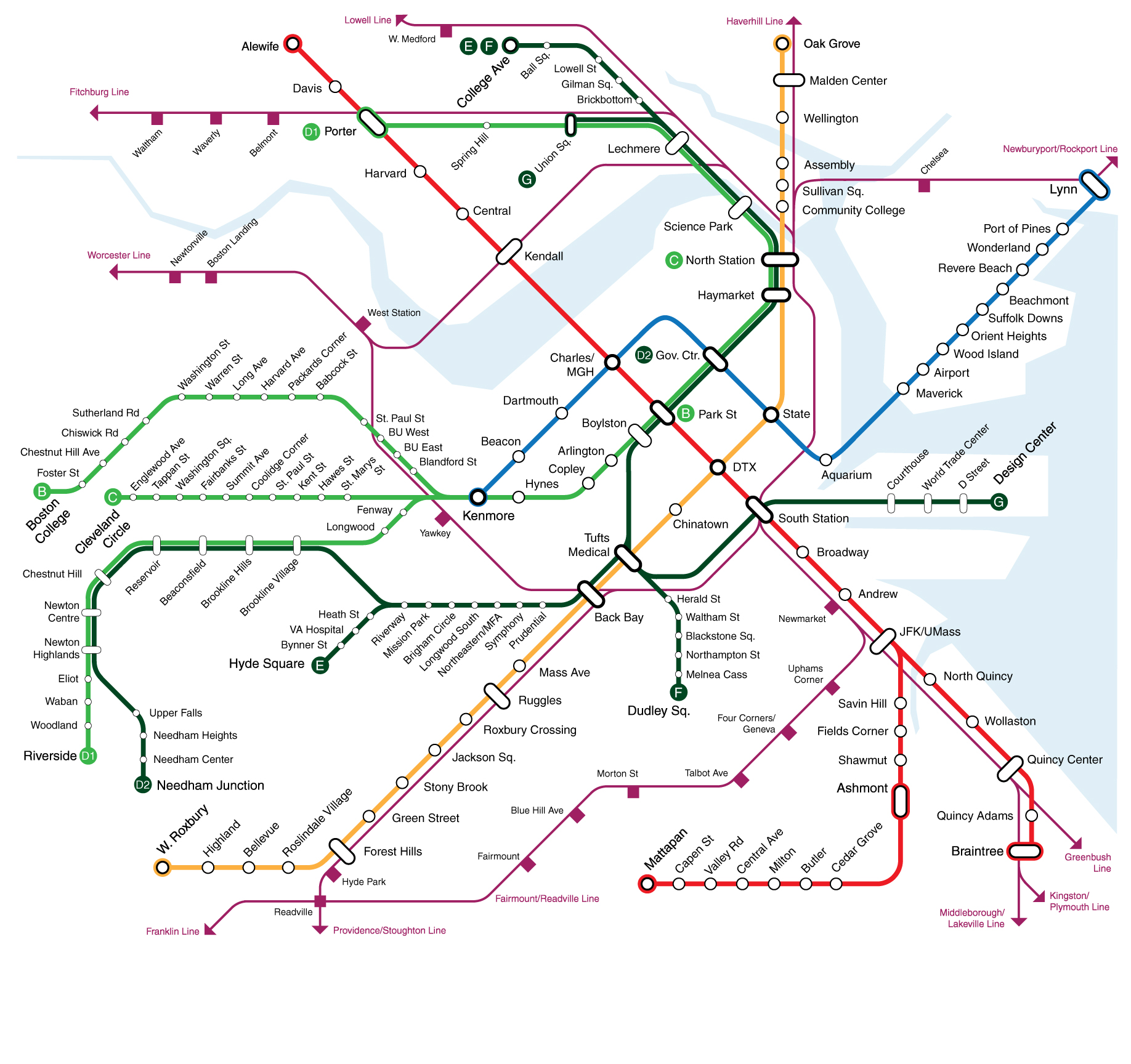
Here's my "reasonable" map that's been bouncing around threads.
stick n move
Superstar
- Joined
- Oct 14, 2009
- Messages
- 12,076
- Reaction score
- 18,829
So even without nsrl I wonder if theyll use west station for transfers to north station on the framingham worcester line.
F-Line to Dudley
Senior Member
- Joined
- Nov 2, 2010
- Messages
- 9,549
- Reaction score
- 10,411
So even without nsrl I wonder if theyll use west station for transfers to north station on the framingham worcester line.
Absolutely, if the Grand Junction gets converted to light rail. West would be the first stop on the Harvard Branch. As covered extensively here, you do NOT need NSRL to take the line off the RR network.
As a RER shuttle, though, the Grand Junction's severe capacity limitations make Urban Rail frequencies very unlikely. A well-functioning Orange Line out of BBY also sustains near-even travel times on the transfer. So while some people may opt for the West shuttle, it'll be very limited until you do that Urban Ring rapid transit conversion. De-gunking Orange congestion has much higher upside right now for hitting NS off a supersized Worcester/Riverside schedule.
Absolutely, if the Grand Junction gets converted to light rail. West would be the first stop on the Harvard Branch. As covered extensively here, you do NOT need NSRL to take the line off the RR network.
True but you would lose the ability to train moves easily, no?
stevebikes
Active Member
- Joined
- May 14, 2013
- Messages
- 277
- Reaction score
- 103
I'm sad that even on fantasy maps I can't get a Silver Line route from Andrew up D St to the Seaport.
Equilibria
Senior Member
- Joined
- May 6, 2007
- Messages
- 7,083
- Reaction score
- 8,310
I'm sad that even on fantasy maps I can't get a Silver Line route from Andrew up D St to the Seaport.
It was in the 2015 SBW Transportation Plan...
F-Line to Dudley
Senior Member
- Joined
- Nov 2, 2010
- Messages
- 9,549
- Reaction score
- 10,411
No. Southside vs. Northside equipment independence limits the rate of swap moves such that 1-2x per week (chained onto normal Downeaster swaps) via the Worcester County detour uses about as much resources as 1-2x daily moves through Cambridge. Electrify 2/3 of the southside equipment pool under RER and you basically achieve this operating ratio. So this can be a much nearer-term target than it seems, thanks to the RER initiative.True but you would lose the ability to train moves easily, no?
Downburst
Senior Member
- Joined
- Jul 20, 2012
- Messages
- 1,452
- Reaction score
- 347
Here's one originally posted by Downburst:
Thanks for sharing, Hubman! I've let this map and other projects languish for a while now- I have a lot less free time than I used to- but I'm inspired by this thread and working on a new version. Look for it soon!
This map by Omaja, btw what happened to him.
http://i.imgur.com/mcF62.png
http://i.imgur.com/mcF62.png
Last edited:
Here's one originally posted by Downburst:

I'm a big fan of this one.
Biggest thing it's missing is a Central Station for the commuter rail, although I'd suggest moving North Station closer to Haymarket instead of building a Central Station.
There are only 4 lines on the North Side Commuter Rail, so you could have all of those lines use the NSRL and go south. I'd say that Fairmount, Worcester, Franklin, and Providence would be the 3 lines to connect to.
South Station could still be used as a terminal station for the Old Colony lines and Acela/Amtrak.
This map by Omaja
Ah yes, the good ole days of really crazy transit pitches. (Subway between Boylston and Charles/MGH, I'm looking at you.)
Gorgeous map, though.
WormtownNative
Active Member
- Joined
- Dec 7, 2014
- Messages
- 501
- Reaction score
- 264
A couple more, believe they're both from DaveM (is he still floating around on here? Haven't seen him in awhile.)
Mass(T)ransit:
https://www.google.com/maps/d/viewer?mid=1CNfTAloGvWW1gxBi__YfbemKx9M&ll=42.01469094124801%2C-71.36135905981064&z=10

Green Line Reconfiguration, resurrected from the Green Line Reconfiguration thread:
https://www.google.com/maps/d/viewer?mid=1OW7jWqcH40kDQ5StaPeVEkwZm7s&ll=42.34916836471699%2C-71.0864085&z=11

Mass(T)ransit:
https://www.google.com/maps/d/viewer?mid=1CNfTAloGvWW1gxBi__YfbemKx9M&ll=42.01469094124801%2C-71.36135905981064&z=10

Green Line Reconfiguration, resurrected from the Green Line Reconfiguration thread:
https://www.google.com/maps/d/viewer?mid=1OW7jWqcH40kDQ5StaPeVEkwZm7s&ll=42.34916836471699%2C-71.0864085&z=11

Charlie_mta
Senior Member
- Joined
- Jul 15, 2006
- Messages
- 4,555
- Reaction score
- 6,473
I like the Blue Line to Watertown Square on the above map ^.
Extend the proposed Red-Blue Connector along along the south side of a narrowed Storrow DR., then through Kenmore and Comm Ave by BU in a tunnel, then on a viaduct on the south side of the Mass Pike to the proposed West Station, then on a viaduct along the north side of the Pike through Allston, then cross the Charles on a bridge west of Home Depot near Arsenal Street, then elevated on Arsenal Street to Watertown Square. All elevated route west of the BU Bridge, but something Boston metro will need to get used to for cost effective rapid transit extensions. Elevated structures now are pretty decent looking, nothing like the ones 100 years ago.
Extend the proposed Red-Blue Connector along along the south side of a narrowed Storrow DR., then through Kenmore and Comm Ave by BU in a tunnel, then on a viaduct on the south side of the Mass Pike to the proposed West Station, then on a viaduct along the north side of the Pike through Allston, then cross the Charles on a bridge west of Home Depot near Arsenal Street, then elevated on Arsenal Street to Watertown Square. All elevated route west of the BU Bridge, but something Boston metro will need to get used to for cost effective rapid transit extensions. Elevated structures now are pretty decent looking, nothing like the ones 100 years ago.
I like the Blue Line to Watertown Square on the above map ^.
Extend the proposed Red-Blue Connector along along the south side of a narrowed Storrow DR., then through Kenmore and Comm Ave by BU in a tunnel, then on a viaduct on the south side of the Mass Pike to the proposed West Station, then on a viaduct along the north side of the Pike through Allston, then cross the Charles on a bridge west of Home Depot near Arsenal Street, then elevated on Arsenal Street to Watertown Square. All elevated route west of the BU Bridge, but something Boston metro will need to get used to for cost effective rapid transit extensions. Elevated structures now are pretty decent looking, nothing like the ones 100 years ago.
I've been searching for the discussion on it for the past week. What is the alignment of the BL between Storrow and Kenmore? Isn't the Muddy River almost certainly an engineering money-pit waiting to happen? Also, is Kenmore getting underpinned by the blue? Or will it run tangent to the Green Line platforms? This small section seems like mission critical for the blue line extension past Charles MGH.
I've been searching for the discussion on it for the past week. What is the alignment of the BL between Storrow and Kenmore? Isn't the Muddy River almost certainly an engineering money-pit waiting to happen? Also, is Kenmore getting underpinned by the blue? Or will it run tangent to the Green Line platforms? This small section seems like mission critical for the blue line extension past Charles MGH.
In that map B line is rerouted to GJR. So I assume would the Blue Line goes under Beacon St to Kenmore where it gets a station around the existing Westbound Green Line platforms before continuing into a tunnel under the Comm Ave median. Then C&D use the current Eastbound platforms in both direction.
F-Line to Dudley
Senior Member
- Joined
- Nov 2, 2010
- Messages
- 9,549
- Reaction score
- 10,411
I've been searching for the discussion on it for the past week. What is the alignment of the BL between Storrow and Kenmore? Isn't the Muddy River almost certainly an engineering money-pit waiting to happen? Also, is Kenmore getting underpinned by the blue? Or will it run tangent to the Green Line platforms? This small section seems like mission critical for the blue line extension past Charles MGH.
The tunnel (remember: Storrow teardown an ironclad requirement) would cross diagonally between the Back St./Charlesgate East intersection to the Beacon/Charlesgate West intersection. The Muddy is doing its Bowker-era 'noodle'-shape channel here so the angle of intersection with the tunnel is pretty favorable. Hell, if the tunneling re-channeled the river once more to have a natural/non-concrete channel above and daylighted it to the Charles it would be a thousandfold improvement since the 1950's MDC channeling work on this block is an ecological disaster. As for how it slips under...probably a shield on the roof, but it's not that deep or wide a river so probably negligible added expense.
Station @ Kenmore, since it approaches from the Beacon side, can be structurally offset from underpinning the GL platform. Start at/around Raleigh St., end the platform as close to the busway as steers clear of the Green level. Tail tracks would point to Brookline Ave. (note: banging a right under Pike/B&A is the only way you can on-alignment for further extension...anywhere: swallowing D, going under B&A to Allston, etc.). So the only thing that would cross-cut under Green is the actual mainline, not the Blue-level station.

