Green Line Reconfiguration

That would create a route with a few strange zig-zag parts both to get to and from the Pleasant Street Portal and then to get back over to Washington. Washington Street has plenty of room for a trolley reservation and lanes even at its narrowest point so there is no need for this jump over to Harrison Ave.

Parking would be replaced by a left hand platform at stations and a floating bump out at intersections.
 
Last edited by a moderator:
The Pleasant St Incline is a substantial distance away from where I'm proposing to have the train go over to Harrison, and Washington St has no dedicated bus lanes south of Melnea Cass Blvd so I don't know why you think a train would have plenty of space there.
 
It has plenty of space to add them it is a political will issue there not a space issue. Washington Street has space for lanes at that point as well as long as the parking is removed for a stretch of about 900 feet and there is no need for stops along that stretch so there is plenty of room for two travel lanes, two trolley lanes and sidewalks and after that it is a one-way pair with plenty of space trolley lanes. My assumption was that if light rail vehicles are replacing the SL5 that they will need to meet the Green Line at some point to access the maintenance areas so they should not totally replicate it and should instead go into the Tremont Street Subway at the Pleasant Street portal or in a tunnel that leads from washington street just before the pike to the portal.
 
Last edited by a moderator:
The Pleasant St Incline is a substantial distance away from where I'm proposing to have the train go over to Harrison, and Washington St has no dedicated bus lanes south of Melnea Cass Blvd so I don't know why you think a train would have plenty of space there.

It was already heavily studied and the route on Washington St has enough row for a dedicated ROW for pretty much the entire length. If I recall, the only land taking needed was around the Cathedral, which I think they even had a deal in principal for a swap to take a bit of the sidewalk. There might have been one other with a corner store, but it was the same pretty minor thing. Washington St is pretty much the defacto routing and is very well understood/studied from back when the El came down.
 
My assumption was that if light rail vehicles are replacing the SL5 that they will need to meet the Green Line at some point to access the maintenance areas so they should not totally replicate it and should instead go into the Tremont Street Subway at the Pleasant Street portal or in a tunnel that leads from washington street just before the pike to the portal.

Yes, my assumption was that somewhere near I-90 the train would continue into the Pleasant St Incline, but I was assuming that we don't need to go into those details or the details of where the train continues to the north of Park St to discuss options for routing through the greater Dudley Sq area.
 
Would it be possible to fit a line down warren st to blue hill/seaver or down washington again to eggleston? If a line went all the way there and the fairmont line really becomes the indigo line this would put pretty much the entirety of roxbury within walking distance of the T.
 
Yeah why stop at Dale Street when you can continue to Franklin Park?

In fact you could turn onto American Legion Highway and terminate at the shopping center there for some TOD opportunities.
 
Yes, my assumption was that somewhere near I-90 the train would continue into the Pleasant St Incline, but I was assuming that we don't need to go into those details or the details of where the train continues to the north of Park St to discuss options for routing through the greater Dudley Sq area.

My only point there was that you have a much longer route whether tunneled or done with bus lanes to get from Harrison Ave to the portal than from Washington Street to the portal.
 
In a MassDOT study of the needs in roxbury, dorchester, and mattapan they discuss the potential for light rail through warren and all the way to mattapan down blue hill ave. It's on page 52-53.
 
In a MassDOT study of the needs in roxbury, dorchester, and mattapan they discuss the potential for light rail through warren and all the way to mattapan down blue hill ave. It's on page 52-53.

Interesting. It explicitly says ``concerns about [...] the narrowness of Washington St on the approach to Dudley Station--remain''. I think that probably supports the argument that if we're going to do a future study of the options for a Green Line branch replacing SL5, the study ought to look at both the option of following Washington St all the way to the traditional Dudley Station location, as well as the Eustis / Renfrew / Harrison alternative. (And the latter should be willing to put the tracks through unutilized / underutilized land adjacent to Renfrew, too, if that will lead to smoother operations for the trains.)

At the end of page 53 and beginning of 54, they explicitly acknowledge that the south end of Warren St is narrow and then says that they decided to just ignore that and assume that they could take dedicated space and estimate what the market demand is. Page 54 also has illustrations of taking the center of the road for light rail and having travel lanes for private automobiles on the outside.

(And then after that they go on to pretend that Tesla, Proterra, etc don't exist and analyze air quality; perhaps that was appropriate at the time of the study, but it's going to become less and less relevant as time goes on in the future.)

Protected cycle tracks are also something to consider. The south end of Warren St appears to be too narrow to accommodate a bidirectional transit reservation plus bidirectional lanes for private automobiles plus bidirectional cycle lanes. Maybe cycle tracks plus southbound transit reservation plus southbound private automobile travel lane plus northbound shared transit and private automobile lane would work.

If a Dale St terminal is built, the design of the terminal itself would not have any characteristics that would make a further southward extension difficult. Contrast that with Dudley Station, where if the plan were to never extend beyond Dudley Station, you might get a design like where SL4/SL5 turn around now that doesn't directly work with a southward extension.
 
My only point there was that you have a much longer route whether tunneled or done with bus lanes to get from Harrison Ave to the portal than from Washington Street to the portal.

The distance from the portal to the Washington / Eustis intersection is the same regardless of whether you take Washington or Harrison from the Washington / Eustis intersection to the Warren / Harrison intersection.

The Measure Distance tool in Google Maps tells me that Washington / Eustis to Warren / Harrison via Eustis, Renfrew, and Harrison is about 1650'. Via Washington St and diagonally across Dudley Station it might be more like 1850', so it looks like the Harrison route will probably turn out a bit shorter and faster for the folks boarding at Walnut Ave / Dale St.
 
Yeah why stop at Dale Street when you can continue to Franklin Park?

I want to focus on defining a reasonable phase 1 project at this point, something that balances providing some real utility vs minimizing the number of segments that neighbors might be so concerned about that they might want to kill the project. Dudley Station as the southern terminus is something I don't like because I think that might create opportunities to design Dudley Station in a way that wouldn't work well with a further extension southward. Eustis / Renfrew / Harrison is best done with at least one stop to the south of Dudley St since Harrison at Dudley St doesn't connect well with Warren St buses that continue to the Orange Line. I think providing adequate service and connectivity therefore probably is best done with phase 1 going at least as far south as about Walnut Ave, and the Dale St extension provides more space for the terminal.

I want to save the discussion about the narrow southern end of Warren St for phase 2.

In fact you could turn onto American Legion Highway and terminate at the shopping center there for some TOD opportunities.

Maybe. It does have over a mile of travel through a relatively unpopulated area (but I guess Arlington Heights to Lexington is probably even worse), but the ROW would be easily available with a road diet. But Walk Hill St bus service to Forest Hills might be a lot more cost effective.
 
(And then after that they go on to pretend that Tesla, Proterra, etc don't exist and analyze air quality; perhaps that was appropriate at the time of the study, but it's going to become less and less relevant as time goes on in the future.)

I also think taking that all the bus routes would end as a given and that they could not be rerouted to better connect to the train expansion is faulty analysis and underestimates the potential ridership.
 
I want to focus on defining a reasonable phase 1 project at this point, something that balances providing some real utility vs minimizing the number of segments that neighbors might be so concerned about that they might want to kill the project. Dudley Station as the southern terminus is something I don't like because I think that might create opportunities to design Dudley Station in a way that wouldn't work well with a further extension southward. Eustis / Renfrew / Harrison is best done with at least one stop to the south of Dudley St since Harrison at Dudley St doesn't connect well with Warren St buses that continue to the Orange Line. I think providing adequate service and connectivity therefore probably is best done with phase 1 going at least as far south as about Walnut Ave, and the Dale St extension provides more space for the terminal.

I want to save the discussion about the narrow southern end of Warren St for phase 2.


Maybe. It does have over a mile of travel through a relatively unpopulated area (but I guess Arlington Heights to Lexington is probably even worse), but the ROW would be easily available with a road diet. But Walk Hill St bus service to Forest Hills might be a lot more cost effective.

I agree walnut, Dale, or MLK would make a lot of sense for a phase 1 orpotentially a phase 2 is dudley is explicitly planned to allow it (I am also worried that bringing a line there would be seen as adequate even though it would still leave the vast majority of roxbury under served).

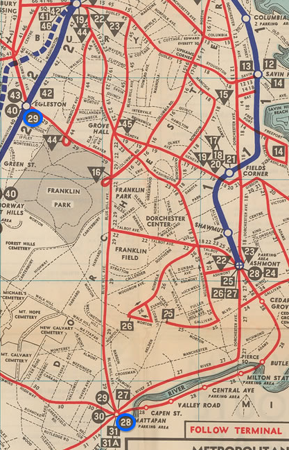
I think returning streetcars to blue hill ave (which used to have a line, so did warren actually) makes much more sense than going through the parks/cemeteries, there is a lot more density along that corridor.

Pic of the lines that were there in the 40s:
5461324_orig.png
 
I also think taking that all the bus routes would end as a given and that they could not be rerouted to better connect to the train expansion is faulty analysis and underestimates the potential ridership.

I agree that they were probably assuming too much in the way of bus route cancellation. My assumption is that if we get a train that goes from somewhere north of Lechmere to Park St and then continues along Washington St (and maybe Harrison south of Renfrew) and ends on Warren St just south of Dale St, that train would be the replacement for SL5, and if we figure out how to also use the track from Dale St to roughly the intersection of Washington and I-90 for another train to South Station / Court House / WTC / Silver Line Way, that train would replace SL4. However, a lot of the major bus routes run through Dudley, often to provide connections between residential areas and the Orange Line, and I think keeping those Orange Line connections probably has value. If the Green Line terminus ends up at Dale St, my assumption is that the only bus service that should be canceled is SL5 (and SL4 if there's also a train to replace SL4).

I also want to see 23 continued to Central Sq in Cambridge (in part so that 1 from Harvard Sq in Cambridge can be rerouted to serve UMass Boston after Boston Medical Center instead of backtracking to serve Dudley after Boston Medical Center) and 28 to Kendall and Lechmere and Sullivan and the casino.

42 and 66 and perhaps some others would need to be extended a bit if the Harrison routing ends up being used so that they would meet the Green Line in the greater Dudley area. That might involve creating bus stops on Harrison on the southbound side of the avenue just north of Dudley St where those buses could lay over.

If we get the Green Line all the way to Mattapan, then maybe 28 can be canceled, but having some route continue to Kendall / Lechmere / Sullivan / casino would still be useful.
 
I agree walnut, Dale, or MLK would make a lot of sense for a phase 1 orpotentially a phase 2 is dudley is explicitly planned to allow it (I am also worried that bringing a line there would be seen as adequate even though it would still leave the vast majority of roxbury under served).

Google Maps seems to think that, aside from a bit of Franklin Park, the southernmost part of Roxbury is Talbot Ave. Maybe Blue Hill Ave at Talbot Ave would be a good phase 2 terminus, with the possibility of phase 3 to Mattapan; getting to Talbot does require dealing with the difficult width at the southern end of Warren, but the rumors I've seen suggest that 28X opposition was well south of Talbot.

But I'm also wondering whether some sort of bus service enhancement in conjunction with Green Line to Dale St could make progress towards improving transit in Roxbury. What, if anything, does Green Line to the Talbot / Blue Hill Ave intersection accomplish that we couldn't accomplish with Green Line to Dale St plus better buses?

I think returning streetcars to blue hill ave (which used to have a line, so did warren actually) makes much more sense than going through the parks/cemeteries, there is a lot more density along that corridor.

I'd looked at that comment and assumed that we might send the SL4 replacement train from South Station to American Legion Highway and send the SL5 replacement train from Park St down Blue Hill Ave to Mattapan.
 
https://streetmix.net/JoelNWeberII/8/warren-st-south-of-dale-st-in-boston has some thoughts on what a Dale St terminus might look like.

There are some nuances that are hard to express well in Streetmix: the Green Line tracks need to get directions in Streetmix, but if this acts as a terminus both tracks would be used for trains to arrive and to depart; I used a back to back pair of transit shelters in the center since that seems to be the best way to express an island platform.

How much parking is best to include is an open question.
 
Here is a basic doodle of some Ideas I have had. The main part is replacing and expanding the silverline through Roxbury, chelsea, and Everett, which are all dense urban areas close to downtown but completely (in the case of everett) or almost completely unserved by rail. This could fit into part of an urban ring in a few ways.

Another idea would be to extend the green line E down heath through jackson square then up columbus to blue hill/seaver. The bus routes and car travel from bluehill to seaver to columbus and the former route of the 29 in the map above are incredibly busy and this could help free some of that up and establish connections between lines that could maybe serve as part of an urban ring.

Map descriptions: Red is potential new line replacing and extending silverline
The blue in east boston is a potential sprur up meridian street to eagle hill.
The blue in Roxbury/ mission hill is a an option for an extension of the E line to blue hill/seaver.
The pink is how this could fit into an urban ring. The purple is an inside option for the ring through Mission hill, Dudley and Uphams. The ring could also rely on the washington line but it would leave out north dorchester and the historically populated parts of southie.
Green is a streetcar line down broadway in southie.
 
What, if anything, does Green Line to the Talbot / Blue Hill Ave intersection accomplish that we couldn't accomplish with Green Line to Dale St plus better buses?

I don't think anything really if both are seen as an end goal but the latter would make future expansion easier.

I think you are right about the bus lines and connections, I think with a real urban ring you could cut down on more busses but without that they serve an important role in being able to move across subway lines rather than having to go in and back out.

I like the plan for warren even though I doubt it would be approved dedicated bus lane and dedicated row for light rail? that would be a huge improvement for transit.
 
Google Maps makes it looks like Harrison south of Dudley St might be about 45' wide from curb to curb (excluding the sidewalk width). https://streetmix.net/JoelNWeberII/9/harrison-ave-s-of-dudley-st has a proposal to put a bidirectional bike path on the east side, tracks in the middle, and a southbound travel lane on the west side (since Warren St becomes one way north of Dudley St, it seems that preserving southbound automobile travel on this segment of [Edit: Harrison] is more valuable than northbound travel would be).

https://streetmix.net/JoelNWeberII/10/harrison-ave-n-of-dudley-st-remix and https://streetmix.net/JoelNWeberII/11/harrison-ave-n-of-ziegler-st propose bike lanes and platforms that are continuous past Ziegler St, but a different street layout to the west of the tracks north of vs south of Ziegler. There's probably only enough space to make this work if the Chinese restaurant on the northwest corner of the Dudley St / Harrison intersection can be relocated within the Dudley Sq neighborhood and if the equipment on the northwest corner of the Ziegler / Harrison intersection can be relocated. Immediately north of Dudley St, the goal on the east side of this is to pretty much have everything line up with the stuff on the south side of Dudley St, with Harrison on the north side of Dudley St having to spread out a bit to accommodate the shelters / platforms. The northbound drive lane would probably both be used for buses to pass other buses that are stopped to lay over, as well as for traffic that turns right from Dudley St westbound to Harrison. Ziegler St would be reversed to be westbound only to accommodate buses like 66 and 42 heading over to Washington St. The Ziegler St / Harrison intersection would probably end up signalized.
 
Last edited:

Back
Top