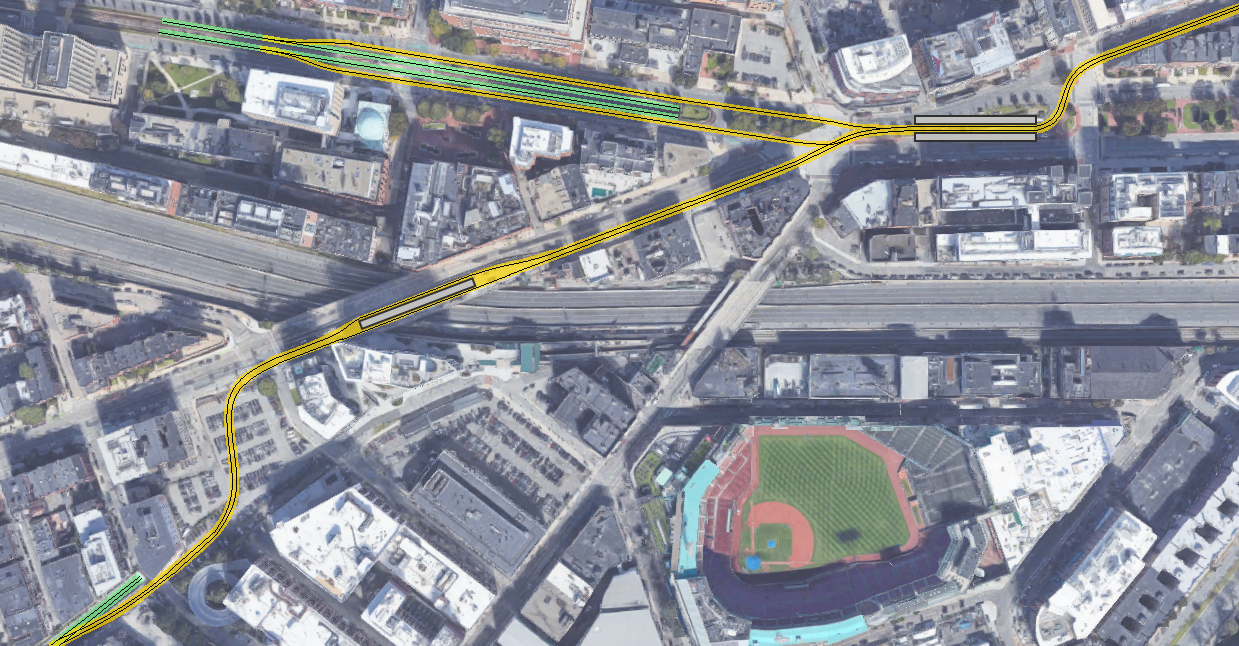
(but man would I not want to live in those buildings around that intersection, that curve would be loud...though hopefully not as loud as the actual Brattle Loop...and with fewer sparks...)
Oof. Yeah. That was an aspect I hadn't fully considered, and I think it renders the whole topic moot if indeed there is no way to minimize/eliminate squeal. That issue kills this entire proposal dead --
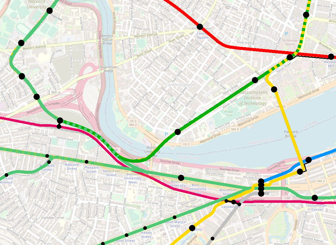
that intersection is extremely residential. The
Track Design Handbook for Light Rail Transit, Second Edition has a section on curving noise, including various remedies. Perhaps an automated lubrication system could keep the noise to a manageable level? But I'm not optimistic.
One potential alternative crossed my mind, although it is highly contingent... In a world where Storrow has been put on a diet, it's possible that the spaghetti of interchanges at Charlesgate will be simplified. If that does come to pass, then there might be opportunity to insert a new LRT ROW somewhere in there. Vague sketch:
Here I've drawn it on the western edge of the (former) interchange's footprint, although it may be preferable to utilize an alignment that is closer to the center of the footprint and further away from homes (e.g. the Beacon-to-Storrow-westbound onramp). But this would be completely dependent on whatever the heck is done with Storrow and Charlesgate. If it's all gonna get blown up, then perhaps there is opportunity.
And the only other wild-ass idea I can think of would be to somehow interface with a Blue Line tunnel as it crosses Charlesgate... relocating the curve underground at least?
[EDIT: perhaps that lot between EB and WB Storrow just west of Mass Ave could be useful? On the satellite it look like park, but I believe it doesn't actually have any pedestrian access. Could be for a portal that connects to an expanded Blue Line tunnel? Or maybe could thread an LRT ROW through the existing spaghetti to Beacon?]
Alas.
I'll reply to the other points for completeness, even if the noise issue renders them moot.
I'm not wild, personally, about the lack of a Kenmore-BU-Cambridgeport leg, given that it would effectively preclude the option of running from the Central Subway out onto the GJ and vice-versa. I'm not sure how common a service pattern that would necessarily be, though I could envision it being desirable at least in certain circumstances. Would also be a mildly more 'elegant' way of getting north-bound Sox fans out of Kenmore without needing to flood the downtown core, without engaging the street running. (To be honest, I'm very curious how that much street running would fare with post-Sox crowds.
The point about the interactions between Fenway crowds and street-running rail service is well-taken, and would be another challenge, though I suspect more surmountable with good station design at Kenmore.
Regarding Kenmore-BU-Cambridgeport: so there's a larger discussion here, actually somewhat related to the system-level analysis I gave you regarding the Park Loops. I should be clear that, absent an eastern approach, I'm completely in favor of a physical Kenmore-BU-GJ connection. It'll be a gamechanger, enabling generations of operational flexibility.
However, I have become increasingly skeptical of running Central Subway (specifically Boylston St Subway) service out on the Grand Junction. Kenmore short-turns? Absolutely. BU-Kenmore-Longwood boomerangs? I can get onboard. But running a service that goes Park-Copley-Kenmore-BU-Cambridgeport-Kendall... that does not make sense to me.
F-Line and I had a big back and forth about this a couple years ago (maybe 10 pages upthread? possibly before you opened your account, Brattle?). I think it's instructive to think of the core tunnels as "faucets" that supply trains out to the branches. The more branches you have, the bigger "faucet" you need to supply trains at adequate frequencies. If your faucet has a maximum capacity of 40 tph, and your service standard calls for 10 tph per branch, then you can have four branches. If you want to have six branches, you'll need a second faucet to supply the extra trains to keep your branch frequencies at 10 tph.
One advantage of the designs we've come up with here for a Back Bay-Boylston-Nubian-Seaport interchange is that it allows Back Bay and Seaport to each be fed by
two faucets: Seaport gets trains from Park
and Back Bay, and Back Bay gets trains from Park
and Seaport. That means, for example, you could get 20 tph between South Station and Seaport without needing to drain 20 tph directly from the Park faucet.
Short-turns have some utility as "faucets", if they are serving segments where many riders will be transferring at the short-turn segment anyway. In this respect, Kenmore
could be a useful short-turn faucet, depending on how transfer behaviors evolve in the coming decades;
maybe you could lower frequencies on the branches below 10 tph if they were supplemented by Kenmore short-turns.
But there are two problems here. First, as you realize by now, the Kenmore Loop doesn't help us with any of the new branches we talk about here: Watertown/Oak Sq, Harvard/Allston, and Grand Junction would
all need to access via Commonwealth, and wouldn't have access to the Loop without reconstruction. (From what I recall, connecting the B to the Loop would be challenging because of the vertical grade changes on either end of the station.)
Second: Beacon and Commonwealth have 130 years of uninterrupted one-seat riders to downtown, and I think almost always at 10 tph peak headways. Making two out of those ten trains per hour short-turn at Kenmore with a forced transfer would pretty unambiguously be a degredation of service and would face enormous generational inertia. (This was one benefit of an eastern approach from Kendall: providing a one-seat ride to MIT, Kendall, and Sullivan -- avoiding the need for transfers to Red and Orange -- could offer a reasonable "consolation" for mild reductions in frequency to downtown.)
My point is that slots in the Boylston St Subway will
always be at a premium, even after D and E are rerouted over to Huntington and Pleasant (and Seaport). Depending how you figure the capacity, you can probably fit 2 other branches in alongside the B/C (although possibly only 1, depending on how things go at Park St). If you could somehow squeeze 40 tph through (plus add another 20-30 tph from Pleasant), then perhaps you could swing a total of 5 branches... but at reduced headways from current capacity. A more realistic ceiling for Boylston St Subway trains would be 30 tph -- which would drop five branches down to 10-minute headways, which I think is too low.
There will always be competition for slots to through-run to downtown. I would prioritize both a Harvard/Allston branch and an Oak Sq branch for such slots over a Grand Junction slot. Once you get past Cambridgeport, it's more direct to go downtown via the Red Line or via Lechmere than via Kenmore. (Which, btw, is what I was trying to show on the map in the post above -- Emerald services run from Park to Harvard, Oak, Boston College, and Cleveland Circle, while Green services through-run from Highland, Nubian, and Seaport to the northern branches, which include a Grand Junction branch that terminates in Allston.)
For sure there is good utility for a Kenmore-Grand Junction service -- but I think its usefulness drops off once it heads east of Kenmore, and therefore should be a short-turn service if at all possible. Save the slots in the Central Subway for services that aren't doubling back on themselves.
It's definitely more straightforward than F-Line's "boomerang" idea on a map, though I don't know if that much street work and street running would wind up being much cheaper or easier than modding the Kenmore loop for the boomerang, which has the advantage of considerably more grade separation at the cost of taking more existing capacity.
Yes, I think this is a valid assessment. I'm more pessimistic on modding the Loop for B access, and an unfortunate downside of the Loop is that it essentially introduces a single revenue track for any route that uses the boomerang. But it's a fair point -- the cost of the streetwork would be non-trivial.
Have to solve the problem of their pathological hatred of street running, wires, transit-lane enforcement, spending money, and building out transit, all at the same time. There's a reason this thread is basically Green Line-specific Crazy Transit Pitches; I think we can assume that the only way anything like this could ever get done is if there's a sea change in management at the state and MBTA level when it comes to LRT.
Alas, yes.
[second reply below due to char limits]