I-695, Soutwst X-Way, Mystic Valley Prkway, S. End Bypass

The last plan around 1969 for the Inner Belt through Cambridge would have crossed the Charles River in a tunnel next to the BU Bridge, and been a depressed roadway through Cambridge, allowing air rights development over the highway.

Given that design, it may have been a good thing for the area. the Inner Belt would have provided a close-in bypass to the downtown Central Artery. I'm thinking that had the Inner Belt been built, the Central Artery between the Callahan Tunnel and the Ted Williams Tunnel/Mass Pike interchange could have been downgraded to a surface boulevard, as the Inner Belt would have served as the primary north-south expressway through Boston.

Thus, the Inner Belt could have avoided the need for the Big Dig through downtown Boston.
 
Charlie_mta said:
I'm thinking that had the Inner Belt been built, the Central Artery between the Callahan Tunnel and the Ted Williams Tunnel/Mass Pike interchange could have been downgraded to a surface boulevard, as the Inner Belt would have served as the primary north-south expressway through Boston.

Thus, the Inner Belt could have avoided the need for the Big Dig through downtown Boston.
Provocative thought; never considered that. It would have damaged both Cambridge and Boston, however.
 
It would have ruined Central Square, Inman Square, and Union Square, either by plowing through them, or by placing a wall of traffic at their edge. No thanks.
 
iven that design, it may have been a good thing for the area. the Inner Belt would have provided a close-in bypass to the downtown Central Artery. I'm thinking that had the Inner Belt been built, the Central Artery between the Callahan Tunnel and the Ted Williams Tunnel/Mass Pike interchange could have been downgraded to a surface boulevard, as the Inner Belt would have served as the primary north-south expressway through Boston.

So basically you're saying that we would have a highway partially covered with ugly development through some of the livliest places in the area and we would still have a hulking, ugly highway through downtown Boston. It would have made the city overrun by cars (why use transit when you can have a nice smooth commute) and increased sprawl. Sure it probably would've helped the economy, but I'd rather have today's Boston over some super economy, highway choked Atlantaesque city anyday. Your points are true, but no matter how you put it I will always see this project as something that could've destroyed Boston as we know it.
 
Unbuilt Boston: The Ghost Cloverleaf of Canton
Wade Roush

In the spirit of ?Little Lanes,? I thought I?d tell you about another strange and mostly-forgotten piece of Boston?s past: the half-abandoned cloverleaf where I-95 meets I-93, on the western edge of the Blue Hills reservation between Canton, MA, and Milton, MA. I stumbled across this forlorn, fascinating place last fall at the end of a hike around the reservation. And while highway construction may sound like an odd subject for a column that?s supposed to be about technology and the Web, I see the Canton cloverleaf as an important technological artifact in its own right. It?s a telling symbol of our own occasional indecision about what we value more: technological conveniences (automobiles, in this case) or coherent, livable communities.

The ghost cloverleaf, which connects to the reservation?s trail system, is an odd sight indeed: a network of curving ramps and a disused six-lane expressway that suddenly dead-ends in a dense, marshy forest. It?s fully outfitted with curbs, drains, and lane markings, but is used today mainly as a refuse dump and long-term parking lot for construction equipment owned by the Massachusetts Highway Department. As you walk along the empty pavement, the main sounds are the chirping of crickets and the distant roar of cars on I-93. (The photo here conveys a bit of the spot?s strange, lonely atmosphere.)

Continues ...The Ghost Cloverleaf of Canton
 
I guess I never paid much attention to the talk about I-695 because I thought it was just an idea, not something actually planned. A lot of you are already familiar with it.

After hearing Governor Dukakis mention it the other night, I had to know more.

He talked about how the new highway would branch off the Southeast Expressway where the Albany off-ramp is today, head up (approximately) where Melnea Cass Boulevard is today (although I think originally more to the left/west of where they ended up building it), across the railroad tracks, to the left of the Museum of Fine Arts (within three feet of it, he said, and he was only slightly exaggerating), across the Fens (next to the Gardner Museum), in front of the Landmark Center, across Beacon, across the Mass Turnpike, over the Charles (or under) where the BU Bridge is now, across Memorial Drive, up Brookline Street through Cambridgeport to Central Square, across, up through Inman Square, into Union Square and then meet with I-93.

The idea had its concept in 1948 and was still seen as a viable plan in 1965, when this book was published:

Preliminary relocation survey: Roxbury district of the city of Boston

...a study of the relocation efforts that will be needed when land taking begins for the proposed innerbelt (Southwest Expressway) in Boston's Roxbury and Fenway neighborhoods; includes a socioeconomic study of the area, welfare statistics, public school data, crime statistics, photos of "typical" buildings and discusses the availability of affordable housing; also includes name and occupation of residents that will be affected for Columbuus Avenue, Sterling Street, Vernon Place-Court, Bills Court, Albany, Weston, Carlow, Hunneman, and Newbern Streets, Harrison Avenue, Washington, Ruggles, Tremont and Field Streets, Tavern Road and Shawmut Avenue; owners of the buildings to be taken are also given together with description and use of the structure and it's assessment; aerial photos showing the path of the highway are included; copies of this item were in the BRA collection...

I found it by way of this guy's site:

http://billwarner.posterous.com/bostons-inner-belt-the-highway-that-was-stopp

The plan was far enough along that estimates of how much they would have to pay property owners were figured.

As everyone knows, the project was canceled in 1970-1971.

Here are some renderings from that book showing where the new highway would go.

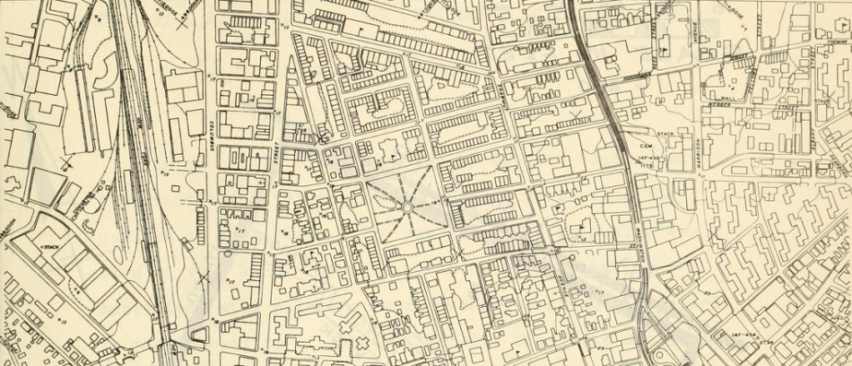
A map showing the neighborhood prior to construction. That's Madison Park in the middle, and the highway would have gone right over it, according to the other images. This is to the west of where Melnea Cass Blvd is, today.

map.png


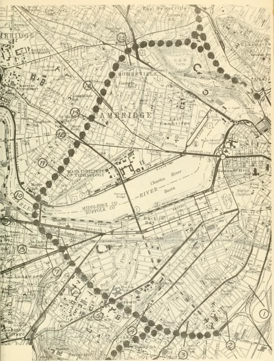
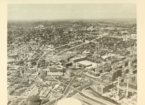
The path of the highway from the Southeast Expressway up to I-93.

i-695.jpg


Lower left on this is Annunciation Road and the Greek Orthodox Cathedral at the corners of Parker and Ruggles Streets heading up across Huntington Ave to the left of the MFA at Museum Road, across the Fens past the Gardner Museum.

695-4.jpg


This part of the Fens actually has a name but I don't remember what the Governor called it. He walks this every day going to work at NeU.

695-5.jpg


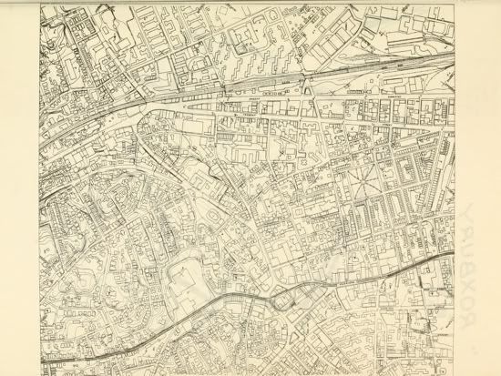
A map of the neighborhood. That's Washington Street at the bottom, Tremont Street at the top - notice the density!

695-6.jpg


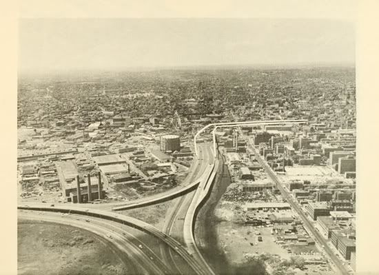
The off-ramp at Albany Street. Notice the Fort Point Channel to the right of the off-ramp. Buried, today!

695-1.jpg


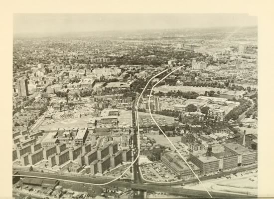
The off-ramp at Albany Street up toward Melnea Cass Blvd. Notice the round building at the bottom - this is now a hotel. Again, the Channel still exists.

695-2.jpg


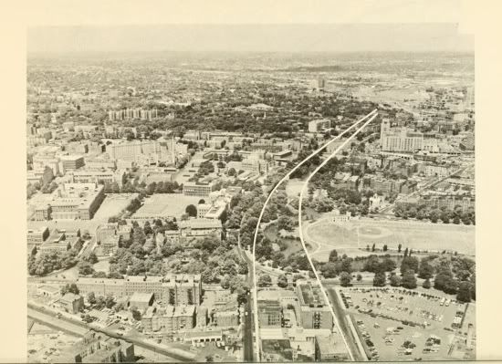
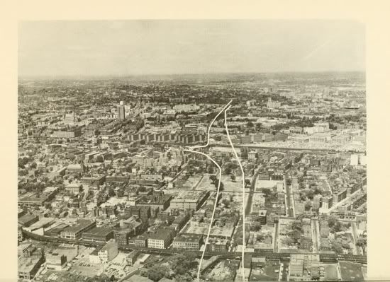
The elevated on Washington Street at the bottom of the photo, right through Madison Park, and northwest.

695-3.jpg
 
Last edited:
Holy crap that's a great find. Somewhere else on the Mapjunction site there is a BRA planning map of Lower Roxbury showing the completed Southwest Expressway/I-695 interchange along with the relocated Orange Line and other urban renewal projects.
 
There was also to be an 8-lane Northwest Expressway (Route 2), which would have paralleled the Fitchburg Division railroad line from the Alewife area to a junction with the Inner Belt east of Union Square.

A part of me wishes these highways had been built. As a kid in the 50's and a teenager in the 60's I watched with excitement the heroic plans for massive freeways and interchanges sweeping across the congested byways of Boston, Cambridge and Somerville. It was to be a new age, a new time of mobility and prosperity, of prying the medieval towns away from their moribund past, of launching the Boston metro area into the future. That seemed to be the same thinking behind the large scale clearing of Boston for urban renewal development.

But somehow in the mid-sixties, people saw the incredible upheaval all of this was creating, and began to call for a stop. The freeways, all but I-93, were cancelled in 1970, and a few subway extensions/relocations took their place. Additional transit line expansions were discussed but never came to pass.
 
Hard to imagine Porter, Union, Inman, or Central squares being desirable neighborhoods today if these freeways had been built.
 
It would be see easy to drive there. And then you could park. And then wonder why you were there, it's just empty lots, and go to Burlington Mall.
 
Thank God that never got built. Yeah, the traffic would flow nicely with the Artery not so overloaded but the Boston renaissance would've never happened with so much of the city and Cambridge getting bombed to smithereens like a giant linear West End. Some of the revised tunnel plans might've worked, but there's still the matter of what ugliness would get built on top of them after everything got leveled for construction. There would've still needed to be the third harbor tunnel for it to work, and the Big Dig would've had to happen regardless because the Artery still was still far substandard interstate design that wouldn't last 50 years.

We'd never have high-speed rail north of New York if any of this got built. The NEC was going to be completely bulldozed from Readville inbound and re-routed over the 2-track Fairmount Line, Back Bay would become a dinky little Worcester Line only station and probably bulldozed into some Yawkey-like platform, and there'd be nothing but 2 tracks of Orange Line next to the highway with shitty Newton Worcester Line-like stations hitting bombed-out Roxbury and taking over the Needham Line to 128. It'd be a functional transit system, but we'd have thrown away all the future capacity for real intercity service even up to today's levels.


Only highway they feasibly could've completed without destroying the city was Route 1 to the 128/95 interchange. That would've made 93 through Somerville and Medford much nicer and less invasive of the surrounding areas. But 1 was only achievable if they made an exception on the moratorium for it and got it done before 1980...never today. Maybe also an east belt from South Bay interchange, third harbor tunnel, 1A, to 1 in Chelsea that bypassed the worst of the Artery at expense of clobbering the SE Expressway (they probably still could grade separate 1A to 16 as expressway today with little opposition through the industrial wasteland, but then there's nowhere to put that traffic when it hits residential/commercial density past 16). I don't think they could've even got 2 built to 93 with it destroying the Mystic River reservation and Medford Sq. and decaying adjoining West Cambridge, East Arlington, and West Somerville to very not-nice places. All the other plans were worse than death.
 
Does anyone know if they are going to redesign the 95-93 split interchange in Canton?
 
It would be see easy to drive there. And then you could park. And then wonder why you were there, it's just empty lots, and go to Burlington Mall.

Ah and Tip could have died a Billionaire not just a mere Millionare -- not bad for someone who grew up in projects, lived in a rental when he was elected and never held a real job except for politician
 
It's slightly difficult for suburbanites driving into the city to navigate, so it must be fixed immediately.
 
Why bother? What's wrong with the interchange as it is?

Awful traffic flow. Full-cloverleaf turning radii aren't designed for mainline thru traffic, they're designed for exits where only a minority of vehicles passing through the interchange are exiting. Every vehicle on 95N has to mash to one lane and go on a sharp curve meriting one of those truck rollover warning signs. Meaning you have trucks slowing every car to 25 MPH, then trying to fully accelerate onto 128N in time for the weaving at the next half-cloverleaf to University Ave. An accident on a ramp like that being pressed into mainline duty means all 95N traffic stops dead with no detour, and traffic heading around the curve to 128N backs up and hoses traffic heading for the 93N exit (3 lanes, center lane divides at the split). It's an interchange design that only could've worked on those volumes had 95 continued straight into Boston.

95S isn't that bad because the 93S-to-95S curve acts as it was originally intended...an exit for a minority of traffic. While 128S-to-95S is the wide-angle side and has less disruptive lane drops. The new flyover ramps in the design are at the same wide high-speed angle and have no lane drops. And it's combined at the same spot with the University Ave. exit to eliminate the mainline weaving and that partial cloverleaf. Can see on Google overhead that they already left a widened shoulder on reconstructed 128 so there'll be no lane drops whatsoever off the new flyover for close to a mile, in time for max acceleration and traffic sorting before the Dedham Corporate Ctr. exit.


Cloverleafs are rare builds today because so many 1960's traffic planners blew it on the traffic count estimates. It's all T interchanges like these designs when one highway ends at another, and stacks or turbines when one major highway crosses another. Higher margin for error on those designs when projecting loads.


MA had a cloverleaf fetish back in the day. Look at all the 128 exits being redone now and every exit down 24 to Taunton. They've got a couple other dysfunctional half-built ones like this to eliminate, such as 295/95 in Attleboro. And others built as intended that need modification because they're far exceeding design load (93/128 Woburn).
 

Back
Top