I-695, Soutwst X-Way, Mystic Valley Prkway, S. End Bypass

F-Line -- now you are posting stuff which is not only feasible -- its nearly imperative

These kinds of "out of the box" ideas need to percolate through to the people who ae atually planning for stuff for the Mass DOT

Try it -- if if works then figure out how to do it better
Ii it doesn't work --- you'll know soon enough and wont have a huge investment
 
Argh. How did I miss this symposia?

If you would like to learn more about the Inner Belt, you can attend one or more of our programs on the history and Legacy of the Inner Belt (April 4, 19, and 25, 2012). These programs have been made possible by the support of Irving House and other contributors. For more information: Inner Belt Symposia

Image below from an Atlantic Cities blog entry by Anthony Flint talking about the symposia.

highway.jpg


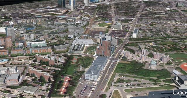
The approximate location, today:
i695.png
 
Last edited:
Looking at those two images I have to wonder if there's any damage the SW Expressway didn't do that it would have had it actually been built (of course the Inner Belt would have done a lot).

Also, interesting how the rendering makes central Boston look hyperdense. All the more reason it needed to be "relieved" with new expressways, of course.
 
Looking at those two images I have to wonder if there's any damage the SW Expressway didn't do that it would have had it actually been built (of course the Inner Belt would have done a lot).

Near as I can tell the Expressway still would have had to plow through/by Curry College and wreak havoc on the Fairmount and Readville lines - and possibly Mattapan too.

And then you figure, the expressway had to end somewhere, and none of the options for where it ends look good to me - merge it into the Mass Pike? Slam the Central Artery even more with two highways worth of traffic? Send it over Storrow and the Tobin to the NE Expressway?

None of those options sound thrilling to me, except possibly the Tobin one.
 
The problem with the Southwest Expressway and Inner Belt wasn't that they weren't good transportation policy.The problem was that there was no room for such a system. The Southeast Expressway did cut through Savin Hill, but much of its route had the harbor on one side, or cut through old South Bay, so not a lot of damage was done. The Southwest version cut right through neighborhoods that had been built out for decades. Sometimes we ask people to suffer for the common good, but in this case there was just too much suffering to justify the costs.
 
Again, at least w/r/t the Southwest Expwy., the cutting was already done and was the cost. I don't get why we act like this was such a great victory. The death swath has been there for years and decades of heavy rail transit being laid down there have not brought new development to stitch these areas back together.
 
Again, at least w/r/t the Southwest Expwy., the cutting was already done and was the cost. I don't get why we act like this was such a great victory. The death swath has been there for years and decades of heavy rail transit being laid down there have not brought new development to stitch these areas back together.

I think it's coming along actually. I've been riding my bike through there for years, and there is definitely a noticeable increase in density through both infill and conversion of decaying industrial buildings.
 
I'm glad that's the case, but there's still a long way to go, and a legacy of decades of highway result boosterism that's pretty unwarranted given the result would have been the same had the highway been built and torn down in, say, 2008.
 
I'm glad that's the case, but there's still a long way to go, and a legacy of decades of highway result boosterism that's pretty unwarranted given the result would have been the same had the highway been built and torn down in, say, 2008.

There is a long way to go, but no, the result would not be the same. The Southwest Corridor park is a tremendous recreational resource for people in Roxbury, JP, and Roslindale. My son's little league baseball team plays games on a beautiful field around the corner from Green Street. It was a real pleasure and convenience for me last night to take the Orange Line to the game after work. The bike path would not be there with the highway, nor would all the basketball courts, tennis courts, joggers and walkers. The neighborhoods on both sides of the park are still dense and well populated, and there is more and more reason for people to cross from one side to the other.

If the highway were there, the neighborhoods would be separated, and the recreational facilities would never have been built.
 
If you want to go with the argument that they had already cleared the land so why not?, then just look at Medford and Somerville with I93. That was the only highway to still be finished after the moratorium. You can't argue that it is harmless.

I also think development would have taken off sooner had they covered the rail with a boulevard. You'd still have the space for parks and the road would fulfill at least part of the function of the highway. A boulevard, Comm Ave style, would have anchored the development and knitted the area together better than just the parks and subway.
 
If you want to go with the argument that they had already cleared the land so why not?, then just look at Medford and Somerville with I93. That was the only highway to still be finished after the moratorium. You can't argue that it is harmless.

I'm not arguing a highway would have been harmless. It would have sucked massively to live next to the thing. But in terms of urban development, has this corridor taken advantage of the fact that it lacked the highway sitting on top of it until fairly recently? No. It's been a mostly wasted opportunity. If the highway had been built and come down a few years ago, would you have noticed the difference, unless you lived adjacent to the corridor and/or would have used its baseball diamonds?

I also think development would have taken off sooner had they covered the rail with a boulevard. You'd still have the space for parks and the road would fulfill at least part of the function of the highway. A boulevard, Comm Ave style, would have anchored the development and knitted the area together better than just the parks and subway.

I hear you on this but I find it ironic that we're often arguing the opposite with regard to the Greenway (that the road detracts significantly from the corridor). I guess it's a matter of attracting development vs. providing an inviting public space, but if we admit the public space requires less traffic, it's problematic to plop a boulevard there in the first place.
 
The parts of the Southwest Corridor that are dominated by a 'boulevard' (from Ruggles down to Jackson Square) are the least inviting parts, and the parts that are still most damaged. From Jackson down to Forest Hills, it's lovely on both sides of the park, and the park is a great asset to that part of JP.
 
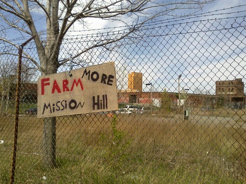
I'm with Ron. Roxbury is already criss-crossed by so many ridiculously large and dangerous roads. Especially Roxbury Crossing. There's enormous empty lots just sitting there next to the station, why aren't they getting developed?

7078115133_ec40de42ca.jpg
 
Does that sign mean the lot is being used as a farm? Sure doesn't look very well cultivated.
 
I'm not arguing a highway would have been harmless. It would have sucked massively to live next to the thing. But in terms of urban development, has this corridor taken advantage of the fact that it lacked the highway sitting on top of it until fairly recently? No. It's been a mostly wasted opportunity. If the highway had been built and come down a few years ago, would you have noticed the difference, unless you lived adjacent to the corridor and/or would have used its baseball diamonds?

I think your thesis is flawed, because it assumes that the park could arrive at it's current state within only a few years time. Thinking about the section Ron refers to as "lovely" (and I agree), it was not always so. 15 years ago, it was probably not too different from the section between Ruggles and Jackson Square. If the highway had been there all along, and come down five years ago, we wouldn't have 25 years of organic development around these parcels. And I suspect that the intervening presence of a highway would have so damaged the surrounding neighborhoods, that 25 years would not even be adequate to get to what is there now.

That is to say, if a highway had been built and later torn down, we might very well be looking at a still damaged neighborhood in the year 2030. That would be 50+ years of harm, compared to the 15 or so that the area actually suffered.
 
The parts of the Southwest Corridor that are dominated by a 'boulevard' (from Ruggles down to Jackson Square) are the least inviting parts, and the parts that are still most damaged. From Jackson down to Forest Hills, it's lovely on both sides of the park, and the park is a great asset to that part of JP.

Yes but Columbus Ave was never designed as a boulevard. It was always an artery with no redeeming qualities. I'm saying if the corridor had been designed more like the Riverway or Comm Ave it would have filled both functions.
 
Nothing is stopping Columbus Avenue from being downsized and reconfigured into a Commonwealth Avenue style roadway or roadway other than a lack of imaginative public officials. It's as overbuilt as the roads bordering the Greenway and cutting through the Seaport District and could easily be slimmed down at the edges or have the median widened and planted.
 

Back
Top