- Joined
- May 25, 2006
- Messages
- 7,034
- Reaction score
- 1,875
Nothing is starting it either.
Near as I can tell the Expressway still would have had to plow through/by Curry College and wreak havoc on the Fairmount and Readville lines - and possibly Mattapan too.
And then you figure, the expressway had to end somewhere, and none of the options for where it ends look good to me - merge it into the Mass Pike? Slam the Central Artery even more with two highways worth of traffic? Send it over Storrow and the Tobin to the NE Expressway?
None of those options sound thrilling to me, except possibly the Tobin one.
I think your thesis is flawed, because it assumes that the park could arrive at it's current state within only a few years time. Thinking about the section Ron refers to as "lovely" (and I agree), it was not always so. 15 years ago, it was probably not too different from the section between Ruggles and Jackson Square. If the highway had been there all along, and come down five years ago, we wouldn't have 25 years of organic development around these parcels. And I suspect that the intervening presence of a highway would have so damaged the surrounding neighborhoods, that 25 years would not even be adequate to get to what is there now.
That is to say, if a highway had been built and later torn down, we might very well be looking at a still damaged neighborhood in the year 2030. That would be 50+ years of harm, compared to the 15 or so that the area actually suffered.
They're still among the more socioeconomically deprived and underdeveloped parts of Boston.
I'm not quite sure what organic development you're talking about. And I'm not sure how terribly the highway would have left these neighborhoods. They're still among the more socioeconomically deprived and underdeveloped parts of Boston. The scar already left by the pre-highway demolition has to account for some of this, and I'm not sure a highway being there would have made it much worse.
Provocative thought; never considered that. It would have damaged both Cambridge and Boston, however.
I assume you never get beyond Melnea Cass blvd. Go down to Lamartine st and think about an eight lane highway within spitting distance. Not much worse? And interstate cloverleaf at Forest Hills? As to socioeconomically disadvantaged - try buying a house between Stony Brook station and Forest Hills. Let's see... here's a two condo 1870s-era house on Lamartine st - assessed value $1 million. You think an interstate wouldnt matter?

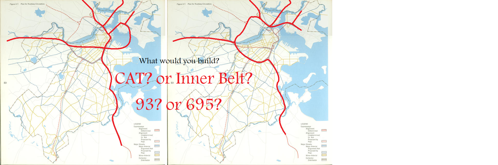
Neither.