I-90 Interchange Improvement Project & West Station | Allston

Thanks for posting this.

I was snooping around google and came across an older slide show from 2018 that has some more detailed renders of west station from angles I havent seen before. Helps visualize it a bit better.

https://www.mass.gov/files/documents/2018/11/20/dot-board-2018Nov19mtg-14-Allston-i90-Board-Mtg.pdf
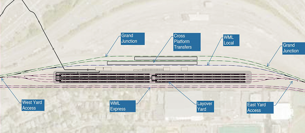
That's way out-of-date. The most recent renders had a 2-platform/3-track station that swapped berths with the layover yard (i.e. layover yard to the south, station north...not station south, layover north like the '18 render). And of course it's all going back into redesign now that the layover yard is being deleted.

weststationflip2.png
 
I'm excited for the wider paths! Anything is better than what's out there now.
 
That's way out-of-date. The most recent renders had a 2-platform/3-track station that swapped berths with the layover yard (i.e. layover yard to the south, station north...not station south, layover north like the '18 render). And of course it's all going back into redesign now that the layover yard is being deleted.

weststationflip2.png
I guess I wasnt clear enough but I was saying its old and out dated but it has some 3d angles that havent been shown before that can help you squint and imagine better what itll look like without the layover yard compared to the top down views.
 
I guess I wasnt clear enough but I was saying its old and out dated but it has some 3d angles that havent been shown before that can help you squint and imagine better what itll look like without the layover yard compared to the top down views.
All of it's obsolete. There's 1 fewer platform, 1 fewer station track, a completely different expressing pattern, the roadway platform over the layover yard doesn't exist anymore, the shared-use path platform over the station doesn't exist anymore, and the 2 Alts. for the busway designs are completely different. Virtually nothing in the 3D renders represents the most recent concepts.
 
Last edited:
In a future with a Greenline UR stop at West Station, will they at least be preprovisioning for a scenario like that?
 
In a future with a Greenline UR stop at West Station, will they at least be preprovisioning for a scenario like that?
Who knows? The previous designs really didn't do any provisioning. As it stands the design needs a lot of work, because the current iteration's split between the express tracks and the local/station tracks is going to create traffic conflicts galore for Worcester express + Amtrak meets/overtakes of the locals. They're looking to start VE'ing it, so I bet the shuttle island platform gets deleted entirely as the Grand Junction dinky is not in a study state where it would be anywhere close to being ready by the time the station starts. That could leave a blank space for later infilling. The top level needs some VE'ing too as the only buses slated to use the station busways are 3 private shuttle jitneys (one to Harvard, one to Kendall, one to the LMA), while the current design is an overbuilt mess that berths a much-excessive 6 simultaneous buses they can't explain where will come from.
 
Interesting post I came across on facebook by the charles river watershed assoc:

“The top image is what the MassDOT Allston Multimodal ("I-90 Project") is projected to look like. The next images are renderings that we commissioned in order to show what the project *could* look like, if we don't expand highway capacity. (The Pike in this area has been coned down to 6 lanes rather than 8 for several years, and would be all during construction; keep in mind the area is going to get a new commuter rail stop too).

What do you think? More asphalt (noise, pollution, heat), building *into* the Charles? Or more parks + trees, more natural riverbank, biodiversity, flood storage, climate resilience?”

1719334247188.png

1719334281231.png

1719334266701.png

1719334303354.png


https://www.facebook.com/share/p/zzbEPKLZ1SmbCVHq/?mibextid=WC7FNe
 
Interesting post I came across on facebook by the charles river watershed assoc:

“The top image is what the MassDOT Allston Multimodal ("I-90 Project") is projected to look like. The next images are renderings that we commissioned in order to show what the project *could* look like, if we don't expand highway capacity. (The Pike in this area has been coned down to 6 lanes rather than 8 for several years, and would be all during construction; keep in mind the area is going to get a new commuter rail stop too).

What do you think? More asphalt (noise, pollution, heat), building *into* the Charles? Or more parks + trees, more natural riverbank, biodiversity, flood storage, climate resilience?”

View attachment 51950
View attachment 51952
View attachment 51951
View attachment 51953

https://www.facebook.com/share/p/zzbEPKLZ1SmbCVHq/?mibextid=WC7FNe
Option 5: 8 lane Mass Pike and no Soldiers Field Rd
 
We're spending $85M to band-aid the current to-be-ripped-down structure in large part because absolutely nobody associated with this project has ever been able to conceptually agree for 5 minutes on what it should look like. Some things never change. Seriously...the lane-reduction ship has sailed. MassDOT has never given an inch on that, and it's been reaffirmed multiple times over that breaching that subject is crossing a red line in the sand. It's past time to pivot to "Now what do we do to make the parkland the best it can get given that the lane capacity is frozen?" But no...the Watershed Assoc. wants to waste more time re-debating settled issues from a minority position. I get it...some stakeholders are really sore that lane reduction isn't on the table. That's a natural reaction. But they're going to get even less of what they want in the end if they simply refuse to ever contour to reality. It's past time to shift focus to the details that go within the set parameters of the lane capacity. Re-debating the lane capacity only serves to drag the process even further out, and make us waste more money in temp band-aids.
 
Interesting post I came across on facebook by the charles river watershed assoc:

“The top image is what the MassDOT Allston Multimodal ("I-90 Project") is projected to look like. The next images are renderings that we commissioned in order to show what the project *could* look like, if we don't expand highway capacity. (The Pike in this area has been coned down to 6 lanes rather than 8 for several years, and would be all during construction; keep in mind the area is going to get a new commuter rail stop too).

What do you think? More asphalt (noise, pollution, heat), building *into* the Charles? Or more parks + trees, more natural riverbank, biodiversity, flood storage, climate resilience?”

View attachment 51950
View attachment 51952
View attachment 51951
View attachment 51953

https://www.facebook.com/share/p/zzbEPKLZ1SmbCVHq/?mibextid=WC7FNe

Any of those three would be amazing.
We're spending $85M to band-aid the current to-be-ripped-down structure in large part because absolutely nobody associated with this project has ever been able to conceptually agree for 5 minutes on what it should look like. Some things never change. Seriously...the lane-reduction ship has sailed. MassDOT has never given an inch on that, and it's been reaffirmed multiple times over that breaching that subject is crossing a red line in the sand. It's past time to pivot to "Now what do we do to make the parkland the best it can get given that the lane capacity is frozen?" But no...the Watershed Assoc. wants to waste more time re-debating settled issues from a minority position. I get it...some stakeholders are really sore that lane reduction isn't on the table. That's a natural reaction. But they're going to get even less of what they want in the end if they simply refuse to ever contour to reality. It's past time to shift focus to the details that go within the set parameters of the lane capacity. Re-debating the lane capacity only serves to drag the process even further out, and make us waste more money in temp band-aids.

A lane reduction here is important enough that I personally am glad somebody is continuing to beat that drum until shovels are in the ground. It ain’t over ‘til the fat lady sings.
 
A lane reduction here is important enough that I personally am glad somebody is continuing to beat that drum until shovels are in the ground. It ain’t over ‘til the fat lady sings.
Yes it is over. MassDOT has said that many, many times already, the money is now flowing to design/construct to the basic designs...and the advocate groups continuing to attempt to drag this out are in an ever-shrinking minority. The fat lady has sung. These groups are now doing themselves a great disservice by ignoring smaller details and debates therein on the configuration of the parklands by continuing to tilt at windmills on settled business. The more they focus on the lanes and not the configuration of the interface with the Charles, the less they are going to get their way on the interface with the Charles. It's not a productive fight in the slightest.
 
Yes it is over. MassDOT has said that many, many times already, the money is now flowing to design/construct to the basic designs...and the advocate groups continuing to attempt to drag this out are in an ever-shrinking minority. The fat lady has sung. These groups are now doing themselves a great disservice by ignoring smaller details and debates therein on the configuration of the parklands by continuing to tilt at windmills on settled business. The more they focus on the lanes and not the configuration of the interface with the Charles, the less they are going to get their way on the interface with the Charles. It's not a productive fight in the slightest.

Have any projects ever been redesigned after initial designs had begun?

If that has never happened once in recorded history, then I 100% agree that “it is over.”

Otherwise, I don’t hear the fat lady singing.

Lost causes are the only ones worth fighting for.
 
Have any projects ever been redesigned after initial designs had begun?

If that has never happened once in recorded history, then I 100% agree that “it is over.”

Otherwise, I don’t hear the fat lady singing.

Lost causes are the only ones worth fighting for.
As F-Line said, if you fight for lost causes, you divert your attention from the ones you can win.

The Federal money is now there and this is moving forward. We fought for over a decade about how to do the throat (to the project's benefit, since it got us an all-at-grade solution). It's f-ing over. Let it go.

Also, CRWA does itself no favors by rendering not just the "don't expand back to the eight lanes it had before" option, but also all the other "options" that have already been discussed and rejected. Ultimately, what this is about is that CRWA doesn't want the bike path in the river, lost that fight, and is trying to hoodwink the public into thinking they're about lane reductions. They were just fine with eight-lane options that kept the roads on viaducts and the path onshore.
 
I'm not a big fan of analysis paralysis and studying a project to death. Get it done. Maybe in the future, in 20 or 30 years, Storrow Drive can be converted to park land.
 
I suppose people have trouble letting it go because it's so obviously just a few obstinate/cruel people in the way. So while it may be true that it's bad to fight for it now, it's just so exceedingly stupid and obvious to someone with a normal perspective on things that it just seems genuinely strange I think. You just have to remember these people live in a parallel universe (and if not that, definitely not in a city!)
 
I'm not a big fan of analysis paralysis and studying a project to death. Get it done. Maybe in the future, in 20 or 30 years, Storrow Drive can be converted to park land.
The longer we're in analysis paralysis over the 'throat', the more design inattention there is to that horrible car-centric Beacon Park street grid and dumpster-fire of a West Station design. Virtually nothing has been done in 10 years to correct those problems, because all the energy and attention has been sucked up by the 'throat' controversies. We're going to be very dissatisfied with the overall end results here if we don't learn to let go of lost battles and get going on the other project dependencies. As it stands, re-litigating the old sucks all the oxygen out of the room for pinning down exactly what the path/parkland configuration vis-a-vis the waterfront is going to be. And we really need to pin that down or else 'shovel-ready' is going to keep slip-sliding away.
 

Back
Top