I-90 Interchange Improvement Project & West Station | Allston

Exhibit 27:
The Alaskan Way Viaduct carried 90,000 cars a day before it was shut down. Where did they all go?

Since the closure of Highway 99 through Seattle on Jan. 11, commute times have been slightly above average — but have fallen far short of the most dire predictions. And fewer cars and trucks than normal have been traveling on the region’s other major highways.

There have been some bad commutes, and we’ll forgive you for knocking on wood before reading too much further. But about halfway through the longest highway closure in local history, Viadoom hasn’t been that doomy.

Public transit seems to have picked up some of the slack, although the two principal transit agencies — King County Metro and Sound Transit — say they can’t yet provide ridership data.

More people are biking to work and more people are taking the water taxi from West Seattle to downtown. But those numbers, while representing significant increases, are negligible compared to the 90,000 cars that used the now-shuttered viaduct each weekday.

https://www.seattletimes.com/seattl...s-a-day-the-viaduct-carried-before-it-closed/
 
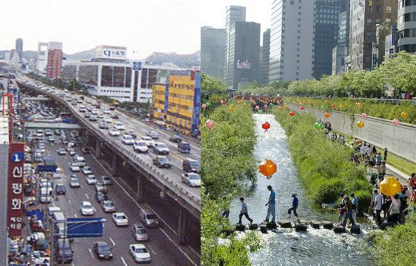
A better example might be the highway that Seoul South Korea tore down and in the process daylighted a river and built a linear park next to the river. If I remember correctly that was a major highway and removing it didn't make traffic any worse.

seoul-before-and-after2.jpg


Wikipedia article about the river
 
But doesn't Seoul have an excellent mass transit system? I'm not sure many cities in the US could so easily reduce car reliance. The closest example we have to this was the Embarcadero, which was a freeway to nowhere. Had it been a useful road, I don't think San Francisco could have handled that loss very well, despite having one of the better mass transit systems in this country. Short term, sure, people can modify utilization (see Los Angeles and the 405), but can you really envision downtown Boston working without the Artery?
 
Yes and part of the removal of several of their highways has been in conjunction with expansions of the mass transit system which is important because that obviously helps. Boston is however in a good position to achieve RER-lite service in the near future even without the rail link if I have understood other posters here and that seems to me like adding 20 or even 30 minute all day frequencies to the rail network would alleviate a lot of the demand for road capacity in the central areas of the city.
 
Agreed. If we implemented something resembling the Transit Matters Regional Rail plan, we could probably dramatically reduce car commuting to the core. And it wouldn't cost that much to do it, either. The challenge is to get political momentum for the idea, so that it starts to have a must be done type of urgency in public discussions.
 
A couple interesting Allston landing renders were there too when I was looking at the ones above.
112716_PLA-AERIAL-copy.jpg

unnamed-1.jpg

Under_Consideration_Allston-BPY-1.jpg


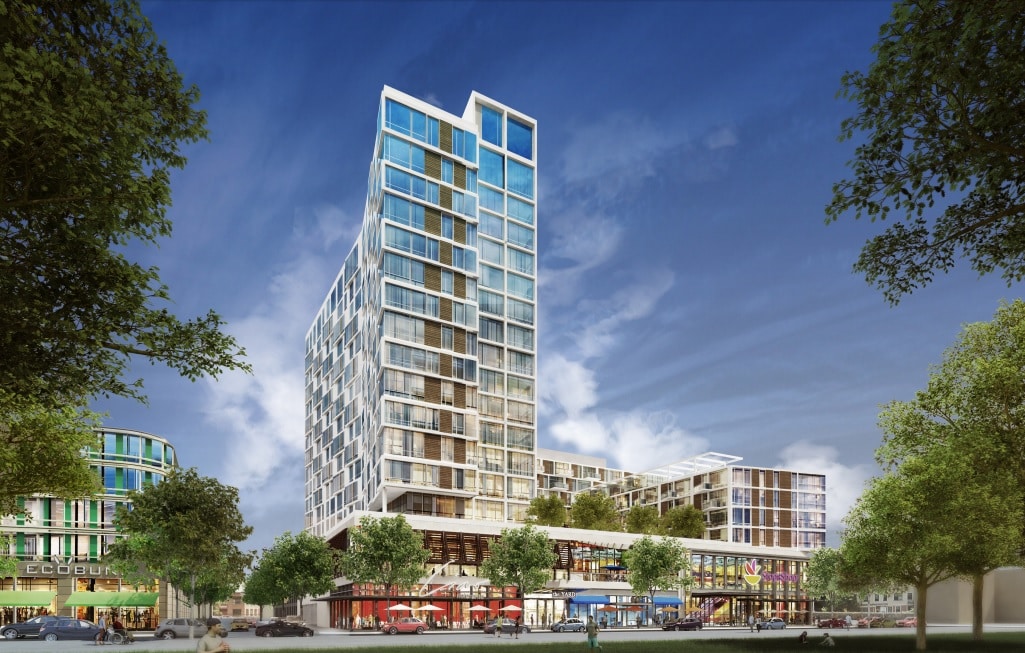
From Banker and Tradesman dated Oct 2018 this shows a pretty shnazzy render labelled Allston Yards with a stop n shop. I wonder if this is the most recent design.
Allston-Yards.jpg
 
Heres a render of all at ground level.
fit


Elevated pike
fit

All the alternatives suck from an aesthetic perspective. A very narrow strip of green doesn't justify the expense of building a new elevated highway.
 
I really wanted to see the bike path be the viaduct, just because it would seem cool to ride up above everything else.
 
Why can'y they just go with this one, but instead of the paved path on land, make a much wider trail bridge a bit out on the river and parallel to SFR? It would be cheaper. I'm pretty sure, than an SFR viaduct. It would also allow landscaping of the shoreline.

33202650178_08f7f0fbcd_z.jpg
 
Why can'y they just go with this one, but instead of the paved path on land, make a much wider trail bridge a bit out on the river and parallel to SFR? It would be cheaper. I'm pretty sure, than an SFR viaduct. It would also allow landscaping of the shoreline.

33202650178_08f7f0fbcd_z.jpg

Or just build a big deck over the whole thing and plant a park on it. Bring it all the way into Comm Ave @ the bridge. You wouldn't be much higher above the water at the edge of it than you are at the end of long wharf at low tide....
 
OK...*ultra*-petty nitpick alert:

For weeks I couldn't put my finger on why every single one of these official renders looked so much uglier than intended. And then it hit me. . .

Can we airbrush out the endless string of CSX intermodal cubes already?!

Beacon Park is years closed, and the final scheduled freight train ever roared through Allston over 2 months ago. Put some sleek new Purple Line EMU set cruising under wire in place or something.
 
Allston Yards is next to Boston Landing, quite distant from the Beacon Park Yard.
 
Why can'y they just go with this one, but instead of the paved path on land, make a much wider trail bridge a bit out on the river and parallel to SFR? It would be cheaper. I'm pretty sure, than an SFR viaduct. It would also allow landscaping of the shoreline.

Because they can't touch the river. It's protected by a hellish permitting process and is a national historical site into the bargain.
 
Why can'y they just go with this one, but instead of the paved path on land, make a much wider trail bridge a bit out on the river and parallel to SFR? It would be cheaper. I'm pretty sure, than an SFR viaduct. It would also allow landscaping of the shoreline.

33202650178_08f7f0fbcd_z.jpg

Or just suck it up and deal with the fact you don't need to spend hundreds of millions extra to pretty up a few hundred feet of sidewalk. There are literally hundreds of places around Boston that have stretches that look ten times worse than that render because people couldn't be bothered to spend $1 million more, let alone tens of millions or hundreds of millions more.
 
^Agreed its literally just a couple hundred feet of concrete that allows you to not have to build a massive, expensive, wasteful viaduct, that will just have to be torn down and replaced again.

Why can'y they just go with this one, but instead of the paved path on land, make a much wider trail bridge a bit out on the river and parallel to SFR? It would be cheaper. I'm pretty sure, than an SFR viaduct. It would also allow landscaping of the shoreline.

33202650178_08f7f0fbcd_z.jpg

I wish this were possible. By far the most reasonable option presented yet. Everybody wins with this and their pretty little shoreline even stays in tact. The bridge would be out in the water... just like you have at the end of memorial in Cambridge. Instead we have to get the shittiest option... because.
 
...and a few well-known stretches that look much, much better precisely because "people" decided to spend literally *billions* more...
 

Back
Top