I-90 Interchange Improvement Project & West Station | Allston

...and a few well-known stretches that look much, much better precisely because "people" decided to spend literally *billions* more...

To the detriment of a lot of other transit and road infrastructure. Yes the greenway is better than the central artery was before... Was it worth the money? Not when there is no money left for other vital projects.
 
To the detriment of a lot of other transit and road infrastructure. Yes the greenway is better than the central artery was before... Was it worth the money? Not when there is no money left for other vital projects.

Ok, I can get behind that POV...
 
masspikecgrfx1.jpg


One thing I dont get is how does the grand junction track cross over from one side of the pike to the other with the pike being at ground level now? Nobody has described how that works. My guess is that the pike stays elevated at the eastern end of the elevated section, where the tracks pass under now, long enough for the grand junction tracks to pass under, then it goes down to ground level with Storrow above it and stays at ground level for the remainder of its length. So off to the left of both of these pictures its elevated for the tracks to pass under, then moves down to ground level. Is this the plan?
https://www.bostonglobe.com/metro/2019/01/10/mass-pike-rebuilt-gorund-level-soldiers-field-road-elevated-giant-allston-project/vV3UpnbIRkgstimTdYNLqM/story.html
 
Last edited:
One thing I dont get is how does the grand junction track cross over from one side of the pike to the other with the pike being at ground level now? Nobody has described how that works. My guess is that the pike stays elevated at the eastern end of the elevated section, where the tracks pass under now, long enough for the grand junction tracks to pass under, then it goes down to ground level with Storrow above it and stays at ground level for the remainder of its length. So off to the left of both of these pictures its elevated for the tracks to pass under, then moves down to ground level. Is this the plan?
https://www.bostonglobe.com/metro/2...ton-project/vV3UpnbIRkgstimTdYNLqM/story.html

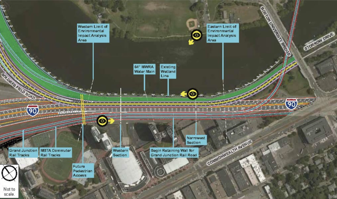
It splits off the Worcester Line at Agganis Way, same place it does today. Inclines up while traveling along the Worcester Line, until it's ~16 ft. above the Worcester tracks atop a retaining wall. Then makes a slight NE bend and crosses the Pike diagonally on a bridge behind the BU CFA building on Comm Ave. to get on alignment with the current Soldiers Field Rd. rail overpass. SFR is back down to grade by this point.

It's in the MassDOT technical renders, clear as day...but it doesn't appear in those 3D drawings for PR purposes of people happily walking next to speeding traffic. And the diagrams of the easternmost project limits just aren't shared as much as the more superficially interesting western limits, so we rarely see that GJ overpass overviewed when the Globe talks about this.

It's there, it fits together and works, it's all logical...blah blah blah.
 
Here are some drawings showing what MassDOT is considering in the throat, including where the GJ crosses over SFR & I90 - https://drive.google.com/open?id=16J_CAoH7AB8_061bBtA5y6Jg8yuqlj62

Also, the Boston Society of Architects Urban Design Committee invites you an
Allston Esplanade Design Workshop

April 18, 2019
4:30-9:00 pm (informal discussion 4:30-5:00)
BSA Space, 290 Congress Street, Boston
Free and Open to the Public
Email rsvp@architects.org to register. Include "Allston Design Workshop" in the subject field

The BSA Urban Design Committee will host a participatory design workshop to generate potential design solutions for key moments of the future “Allston Esplanade,” a large swath of open space that will be created as a result of the planned Allston Viaduct Replacement Project. Beyond rebuilding an interstate toll plaza and repairing a viaduct, this is an opportunity to create new opportunities for city building, as well as creating open space, community connections and safe pedestrian and bike pathways. The charrette builds on over a decade of efforts by design and community advocates, the City of Boston and MassDOT, as well as a BSA Urban Design Workshop.

The evening will begin with an overview of the site and project’s history as well as key opportunities and constraints of MassDOT’s current direction for the Allston Viaduct replacement project. The larger group will break into three smaller groups to more thoroughly address design opportunities at three particular areas through a facilitated charrette. The evening will conclude with each group presenting their work. A summary of the evening’s discussions and design outcomes will be made available to MassDOT and the public.

4:30-5:00 Registration, Networking & Project Background
5:00-6:00 Project History, Opportunity, & Charrette Overview
6:00-8:00 Design Charrette on 3 Sub-Areas
1. The BU/Grand Junction Bridges/Soldiers Field Road/Commonwealth Avenue Nexus;
2. The “Throat” Cross-Section, from river’s edge to highway; and
3. The Agganis Way Crossover
8:00-9:00 Regroup, Presentations by Charrette Teams, & Discussion
 
So, is widening the Grand Junction bridge to accommodate a multi-use trail not part of this project?
 
Here are some drawings showing what MassDOT is considering in the throat, including where the GJ crosses over SFR & I90 - https://drive.google.com/open?id=16J_CAoH7AB8_061bBtA5y6Jg8yuqlj62

Thank you, thats all I needed. Good to see theyre keeping the double tracking option in the plans with this project.

On another note I hope the Krafts and Harvard can work something out for a shared use stadium on the land near the double tree. With West Station there will be transit, plus the Red isnt tooo far, and the bus routes as well, but its looking like this may be one of the last spots left with open land near transit after bayside/suffolk downs etc is built out.

-edit: also those documents show platforms at west station for the grand junction tracks and the commuter rail, then all 4 CR and GJ tracks keep going towards Boston Landing. Is there going to be an additional platform at Boston Landing too for the GJ? Theres 3 tracks there now would the 2 combine into that single track at the station then reverse direction back towards Boston/Cambridge?
 
Last edited:
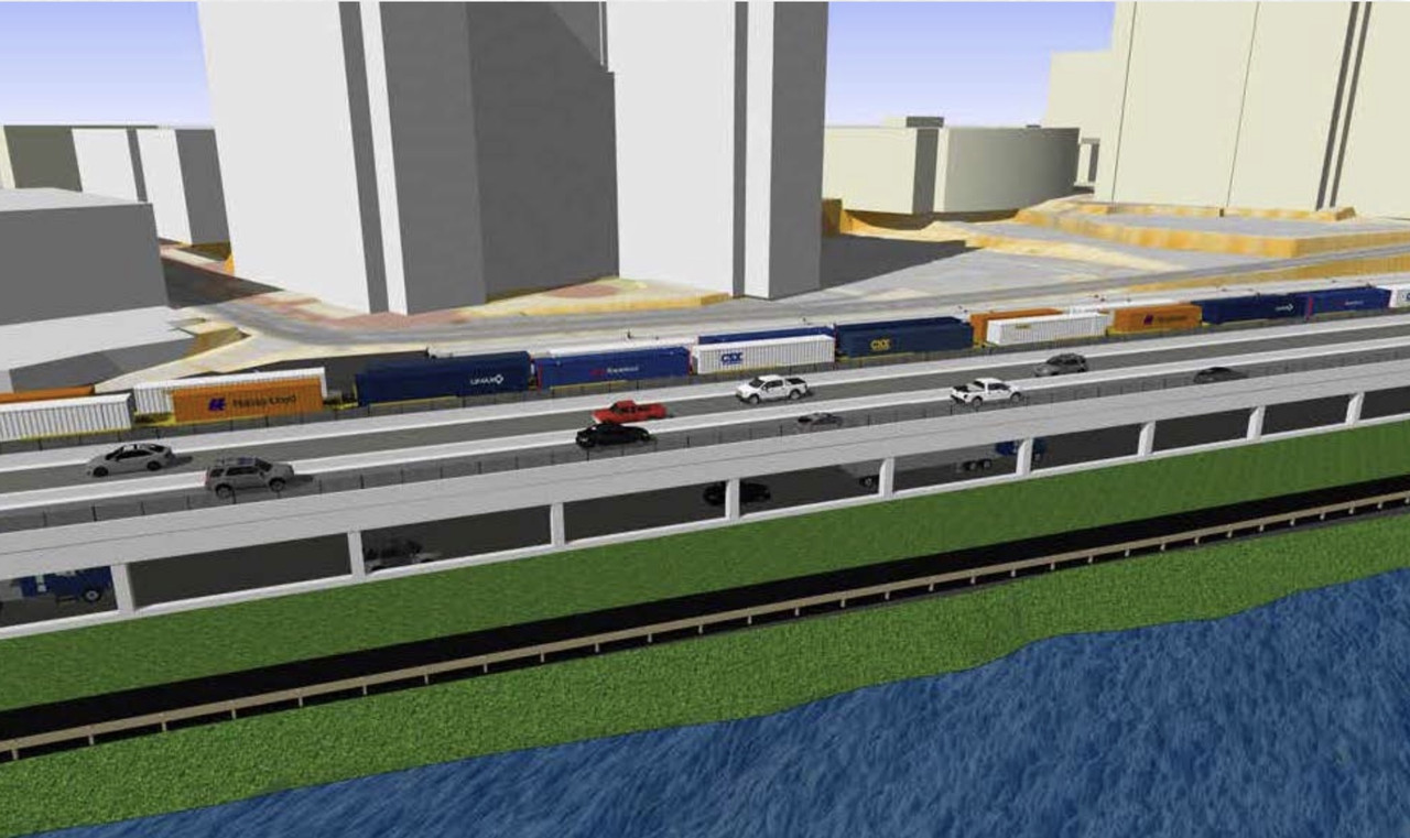
I prefer the "Modified hybrid" option which placed the elevated SFR over the eastbound Mass Pike, rather than over the westbound lanes. It would cost a bit more but would set back the elevated structure further away from the path and the river.

I tend to agree, but looking at the render I think maybe they should put up a sound deadening wall against the side of the pillars to box in the highway noise that is also high enough to block some SFR noise too. They could plant trees and bushes up against it too to hide it. Then youd have no cars flying by at ground level which is going to suck. It would be much better than nothing. I doubt they would do it, but who knows and with the westbound elevation it could be an option. It could even be installed later. Maybe if its brought up theyd consider. Basically all you would see is a wall thats behind a bunch of trees and bushes. I think this would make the path much more pleasant to walk. Im sure they could block it pretty well with enough vegetation and you could always throw some art on it too.

I mean seriously... look at this. Who the hell would want to walk here like this? I think with the cards were dealt a wall would be the best thing to do.
allston.png
 
Last edited:
So, is widening the Grand Junction bridge to accommodate a multi-use trail not part of this project?

Outside of project limits, since any river crossing of the multi-use path would dump onto the Esplanade at BU Bridge/BU Sailing Pavilion first and net all its path connectivity that way.

Frankly, I don't even see a river crossing path happening any time soon because security on the rail bridge is a thorny issue that has to be hashed out. Most likely if they get any sort of starter path done through MIT it's going to end at Cambridgeport or Memorial Drive for the interim, and then they figure bridges out later.
 
Is this still happening? I still can't believe they are proposing the absolute worst alternative for the throat. God I hope this doesn't get built in the next 50 years
 
News!

“FRAMINGHAM – A storm’s brewing for MetroWest and Worcester commuters, the intensity of which we have never seen.”

“The project is estimated to begin sometime after the summer of 2021 and complete in eight to ten years, but we know what can happen to estimates given our not-too-distant experience with the Big Dig.”

“During a large portion of the construction, the Pike will go from four lanes to three, both eastbound and westbound. ”

“In fact, the current staging plan does not offset the negative construction impact on MetroWest and Worcester commuters at all. It actually deepens our pain by:

**reducing the Worcester rail line from two tracks to one track in the project area for what could be five or more years. That means an inbound train will have to wait for an outbound train to pass and vice versa.

The current plan for the Worcester line is simply unacceptable.”

https://framinghamsource.com/index.php/2019/04/27/op-ed-mass-pike-construction-will-impact-framingham-commuters-and-trains-for-years/


- - I wish this coincided with electrification of the Framingham Worcester line and NSRL. Get it all done in one swoop, then leave it for 100 years. If they have to roll right into that from this its gonna be rough. LUCKILY the Rail Vision Study will conclude at the end of 2019, and this isnt planned to start until 2021. That means (WHEN) they are approved *theres no choice..., they will end up being done at the same time, overlapping. Not entirely but the beginning of electrification or NSRL should overlap the final third of the pike realignment.

If not were Pretty much screwed as well sit at 850,000 people going into the 2040s into 2050. The metro area is projected to go over 6 million by 2050.... the CR just so happens to serve this larger population. We have no choice and I fully expect them to act when the Rail Vision study wraps up at the end of 2019. If not.... I cant even imagine.
 
Last edited:
The Pike only has 3 thru lanes in the area now, the 4th lane is not continuous through the Allston tolls. So I'm not very clear from this (and I'm not sure the author is either) on if there's even a reduction in thru capacity at all.

I'm also skeptical (but will certainly defer to whoever has better knowledge of the situation than me) that a single-track in the area for a few years is a particularly insurmountable hurdle, given that it operated with single track for decades up through what, a year ago?
 
Its 4 lanes, drops to 3 during the curve, then goes back to 4. Im sure it wont be that big a deal. Way less than if it had to go from 3 to 2.

Regarding the rail, that should be fine too. They did it in the past, do it on other lines today... wont be a big deal. Theyll just stagger the trains, which they are anyways, and should be minimal disruption (imo).

We do know that large scale projects do tend to be shit show/y. So Im 100% certain its not going to go off without a hitch. But again this is an enormous project. Im hoping that there is the least disruption necessary though.

Well see how far weve come. If they pull this off smooth, if NSRL is not started within 2021-2031 that this takes place, hopefully this will give the public/city/contractors/govt... whoever, confidence that we would be able to pull off another massive downtown tunnel project. I expect it to be started sometime in there, but if not they need to get this right. If you mention a massive tunnel project through downtown it gives people vietnam flashbacks and they break out into a sweat. Look at it now though the greenway is PHENOMENAL, the tunnel is effective, its a smash hit project that made the city better in 100 ways. So would NSRL and electrification. NSRL and the CAT are fundamentally different, but I feel this project can be a confidence builder for the city and the future.
 
Last edited:
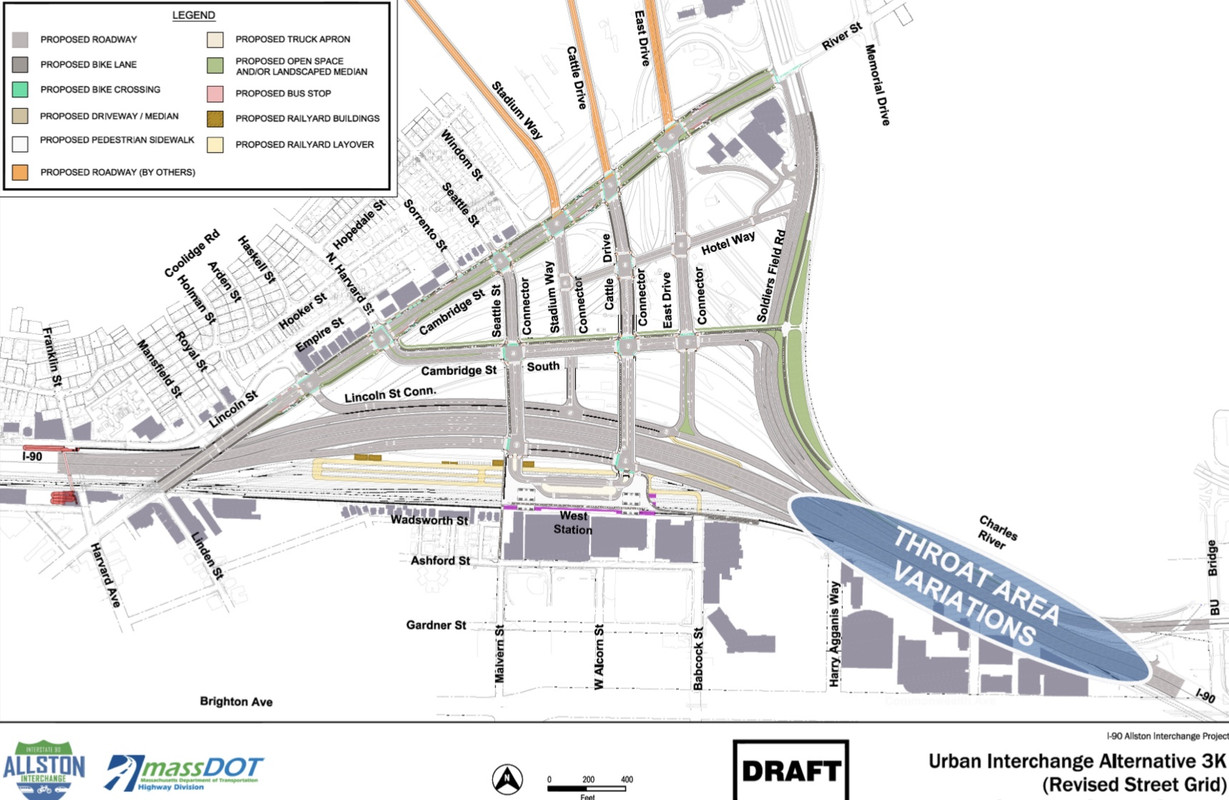
Imo all 3 of these should be connnected. At the least Babcock st, wouldnt be hard at all. For the grand scheme of how big this is, I think they could make it work. With the way they line up now Malvern and Babcock would be great. Looking on maps even as a pedestrian corridor theyre probably going to want to fix the streets up.


One thing I dont get is why Stadium and Cattle arent laid down yet. At least get it finished up to Cambridge st and above for now.

Between Connector and SFR I think is where the Revs stadium should go. Looking on maps it could be built now. Theres going to be west station right there and one day maybe grand junction to Cambridge/North Station. One day theres supposed to be fast intercity EMU’s with 15 min headways running on the CR tracks too. It will be plenty connected, plus the pike is right there and you dont have to go through the city or city streets to get to it, which means no added (city) congestion. Plus like Fenway a new neighborhood is going to fill in around it. Maybe they could even share it with Harvard so they could have a new stadium to use too. Theres not many spots left, I think they should consider.
 
Last edited:
Uhh....the Worcester Line was single-track for the full mile's span of Beacon Park from 1965-2018, causing inbounds to have to pause to wait for outbounds every single day for a half-century. This is not exactly a new thing for MetroWest'ers, but I guess hysteria still nets page clicks for the local-yokel news rags.

There is a brand new set of crossovers that have been installed at Milepost 6, designed to help the Newton bottleneck by allowing train meets much closer to the single-platform stops than the old days when switching tracks could only be done at the west end of Beacon Park. They're hooked up but inactive at the moment, waiting for signal replacement to start for at long last converting the inner half of the line to cab signals (required for the PTC deadline). Depending on whether they're working Boston-out or Framingham-in these switches could go live anywhere from this summer to next. It'll be those new crossovers that will allow for retention of present-day schedule margins when Beacon Park goes under the knife for Pike construction and the temp single-tracking returns.

Not only is this news rag claiming a catastrophe that's functionally no worse than what they were already used to dealing with for 50 years...but the new crossovers will ensure that the temp constriction, while sucky, will still be a good deal BETTER than the permanent restriction they used to have. The Worcester Line's not going to stop dragging the rear on systemwide OTP without a perma-fix for the 3 Newton stops, but it probably isn't going to get any worse than today due to Pike construction because of the presence of that new traffic sorting valve installed at the City line.
 
Last edited:
Does 8-10 years sound a bit long? I understand it's a big project, but they realy can't get it done quicker?
 
Yea it definitely is, maybe theyre just getting out in front of the inevitable delays now, so when it takes that long its expected. Instead of saying 5 and it takes 8 and everyone freaks out. Then on top of it if it takes 6 and they said 8-10 they can say they finished ahead of schedule.
 
In the final build 3 lanes inbound with a dedicated 4th bus lane from exit 17 that leaves the turnpike for city streets before the throat would cut one lane in the throat (7 lanes instead of 8) and potentially help traffic

3 outbound lanes from DT to exit 17 for cars and one dedicated bus lane ending at exit 17 would make buses more attractive for the evening commute, and might help traffic.

Cutting the speed limit to 45mph at rush hours would probably help traffic and safety and not change travel times much.

Connecting most if not all cross streets is a no brainer.
 

Back
Top