If You Were God/Goddess | Transit & Infrastructure Sandbox

George_Apley

Not a Brahmin
Staff member
Joined
Jan 22, 2012
Messages
5,078
Reaction score
1,655
This is your "perfect world", "wipe the slate clean", "perfect lines on the map" infrastructure sandbox thread. Got an idea for something that has no good reason other than "it would be cool"? Or an idea that is so outlandish in terms of the financial, political, ethical, and/or engineering challenges that it would never happen in a million years? This thread is your playspace. Discuss concepts but don't bring in feasibility questions here. It's just for fun.

If you want your concept critiqued for feasibility, post it over in Crazy Transit Pitches and someone will probably dig into it.
 
DaveM had some great maps for proposals over the years, and this is what he envisioned for Greater New England as a whole. I thought it was a bit much for some of the extended commuter rail lines, but it was everything we've talked about and more.

I would also add a few of my own crazy maps - Worcester Rapid Transit & Worcester Regional Rail. Both made when I had entirely too much time on my hands and was drinking too much kool aid of optimism. Probably just haven't hit the Google Drive trash bin yet just due to them not being counted towards my storage limit.

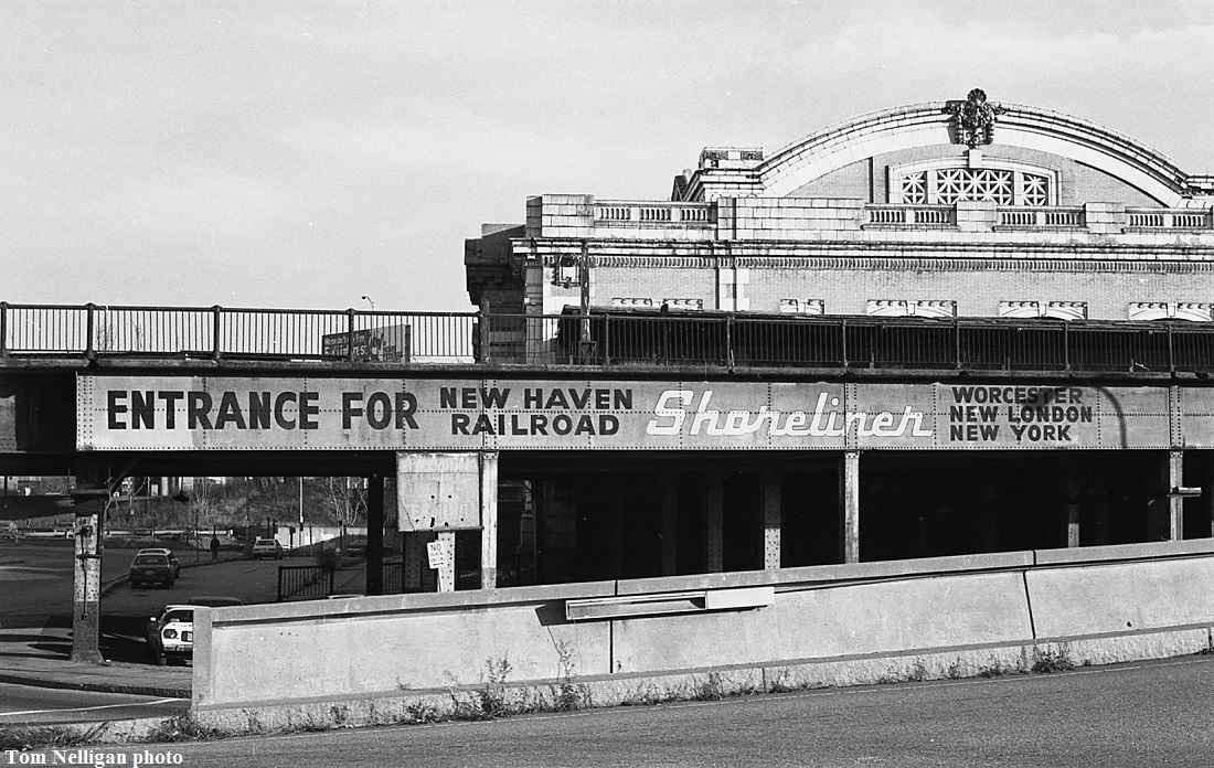
Hey...New London-Worcester commuter shuttle ran until Amtrak A-Day in 1971...way later than anything else north or south out of Worcester (all others ending by '55, and MBTA commuter rail ending just 3 years later in '74). Was called the Shoreliner in the NYNH&H days...nameless the last couple years under Penn Central. It was only discontinued because there was too much of a mess to sort out on short-haul traffic in the New London area stuck in that 'tweener "not long enough for AMTK, not short enough for commuter rail" category. They opted to keep the on-NEC New Haven-New London Clamdigger (basically, Shore Line East by any other name) as an AMTK service and extend it to Providence, much like Springfield Line commuter rail got rebadged as the Shuttles. Service there lasted from A-Day till the 1981 recession, then took the rest of the 80's off until SLE debuted to Old Saybrook in '90. RIDOT started shoveling money at Conrail to mercenary-run Providence-Westerly as a nameless extracurricular commuter train, since the original T district didn't have a subsidy mechanism for keeping that one attached as quasi-continuation of the Penn Central-era Boston-New London super-runs. That lasted till 1979.

The WOR-NLN shuttle apparently had pretty good utilization despite being almost entirely in CT's Quiet Corner and almost entirely duplicated by I-395, so the transit shares of that corridor were always robust. But it simply was the odd man out for attaching to future subsidy. Too far from Conrail Metro Region (pre- Metro North New Haven Line + branches) in New Haven to attach to that subsidy, so ConnDOT was out. Amtrak could handle the interstate subsidy pooling, but it already had the incumbent Inland Route off SPG Hub covering New Haven-Boston so didn't want any other corridors that weren't capable of on-NEC/on-Springfield double-up. And the Worcester, Norwich, & Groton Line's ownership situation was up in the air as dissatisfied P&W shareholders had made their proxy move in 1970 to 'liberate' themselves from Penn Central with termination of the final 21 years of NYNH&H's operating lease on their territory (which consisted of the PRV-WOR mainline, East Providence Branch, and others). Once PC hit bankruptcy they proposed lumping in the Groton Line and the Midland Route from Willimantic to Providence to P&W to dump more unwanted branchline ballast, which is how the 1844-chartered P&W ended up being 'reborn' as the new P&W that exists to this day. Amtrak wanted nothing to do with the Groton Line so long as they'd be dealing with complete unknowns like how a company that hadn't operated its own trains in 80 years was logistically going to restart itself from scratch, so the ex-Shoreliner shuttle quietly expired on A-Day.

1 round-trip per day. Stops at: WORCESTER UNION STATION, Auburn, Webster, Putnam, Danielson, Plainfield, Jewett City, Norwich, NEW LONDON UNION STATION. Distance: 72 miles. Schedule (1955 timetable): 1 NLN-WOR northbound (7:21am dep.-9:12am arr.), 1 WOR-NLN southbound (4:50pm dep.-6:41pm arr.). 6-minute layovers at NLN for cross-ticketed NY/New Haven trains.


advert @ Worcester Union Station, 1981. . .
2018042710112815236.jpg


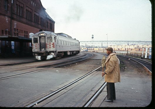
Penn Central Train #579 (southbound from Worcester), arriving New London 4/1970 (note crossing guard)
2019032908013831630.jpg


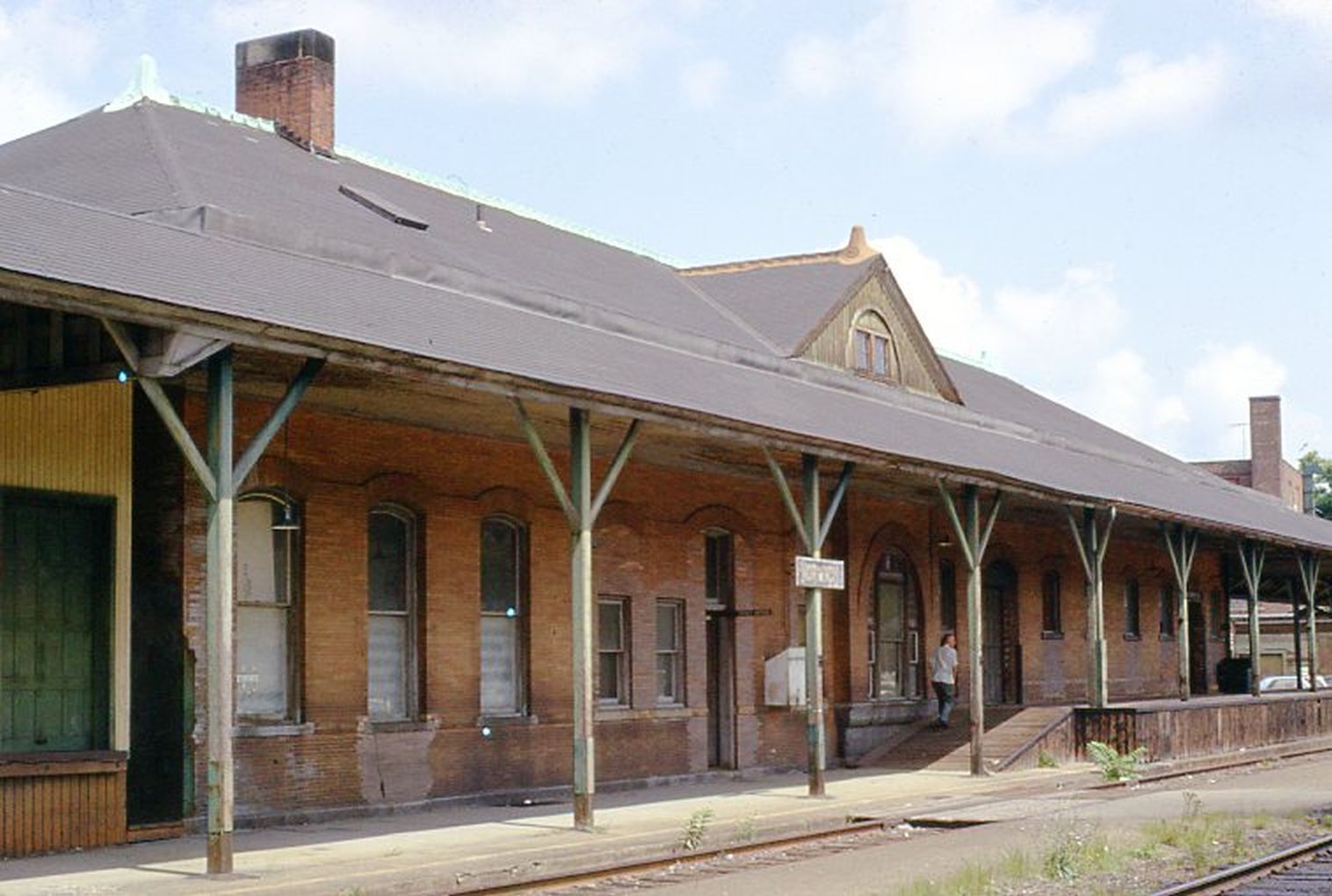
Norwich Depot (w/ high-level platform), 1971 before end-of-service
2019120717430729396.jpg


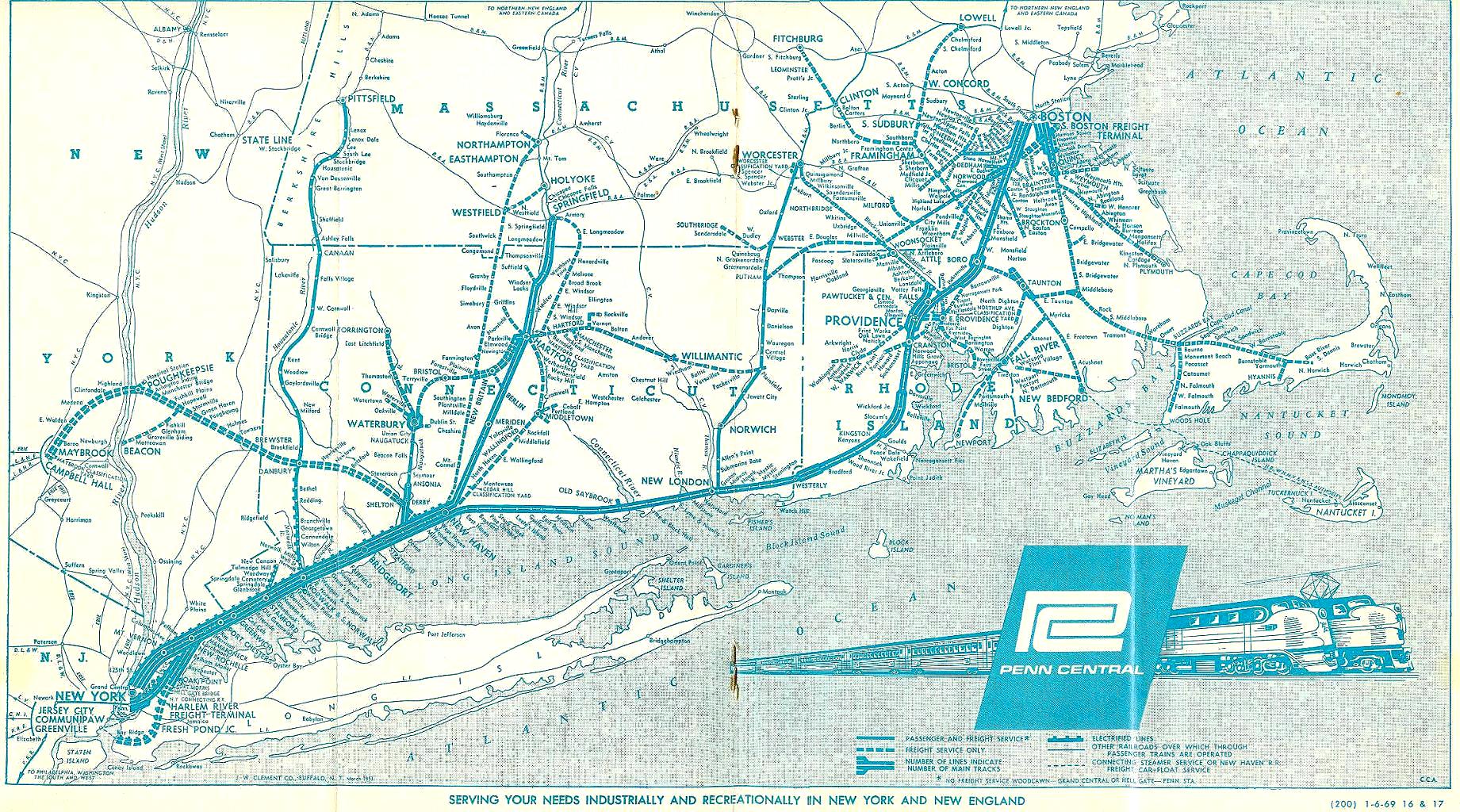
2/2/1969 Penn Central regional map (solid lines are passenger service). . .
pc-ptt-newhaven-map-2-2-69.jpg
 
The only real lines I thought far fetched were the ones that went to Keene & Lake Winnepesauke. The rest were definitely plausible. The Quinebaug Valley and Eastern CT isn't as sleepy as it may appear.
 
Anything Urban Ring. Hub + Spoke is a transit disaster.
That Red Line branch going down Mass Ave on the Boston side is beautiful. It solves the N-S travel issue in such an obvious way.

The Yellow Line ring has been explored by others here too.
 
Having spent so many years as a kid stuck in traffic between Providence and the Cape, I'd love to see part of the I-195 ROW converted into rails in Fall River, and between New Bedford & Wareham. Then eminent domain the properties in Ocean Grove, and convert the bike trail into rail-with-trail, and you could have a real Providence-Hyannis local line. Basically what's in that excellent map above, but with an extra leg to connect to the Cape.

I think if you upzoned the 15 blocks or so of central Hyannis up to the hospital, moved the community college onto part of the Mall parking lot, and built an interurban to Falmouth and... Dennis? Harwich? Chatham? you'd have a neat little network which could possibly function year-round. Especially if you rebuilt the rail to central Falmouth and upzoned accordingly.

But this is an insane eminent-domain budget disaster fantasy.

EDIT: one other point, since I mentioned "upzoning" - it's been several years since I followed these issues closely, but I remember a long time ago that, two major Cape issues have been: 1)increasing traffic, and 2)a housing crisis for the (largely Brazilian) service workers in the Cape's tourism industry. My idea assumes zero NIMBY issues (lol) with adding a decent amount of public housing around whatever rails and stations get built.
 
Last edited:
Big plus-one for this thread idea. I like the division between this, Crazy and Reasonable Transit Pitches. You know what they say... "write drunk, edit sober." So, nice to have a space to "write drunk," as it were.
 
I would do a combined tollway & HSR from Hartford to Providence on the reserved I-384 (nee 84) alignment.
 
I would do a combined tollway & HSR from Hartford to Providence on the reserved I-384 (nee 84) alignment.

That's actually several orders of magnitude less 'divinely' bugfark than the actual NEC FUTURE Midland study alignment, which just attempted to MOAR TUNNEL its way in crayon through the Earth's mantle undereath UConn instead of even looking at all that thousands of acres of I-84 alignment land still owned by ConnDOT 40 years later.

If Biden wins and Dannel Malloy leaves his placeholder job as UMaine chancellor to becomes Transpo Secretary, watch this very alignment become an actual study subject. Because there's going to have to be a pivot away from the I-95 'bunny hop' Preferred Alt., which is as D.O.A. on physical geology as it is on violent community opposition. 384 to Willimantic was conditionally approved in the early-00's on the north-of-Hop River 'greenway' alignment with widely-spaced carriageways in a bid for some FHA fast-tracking funds in GW Bush's 1st term (that mostly ended up going to southern Interstate extensions) before the Army Corps, which was at its politics-playing worst in that era, tanked it by upchucking a singular Preferred Alt. for the much more invasive south-of-Hop River alignment that required close to 10x as many property takings. The fast-tracking window closed, and ConnDOT simply stopped trying from there with implicit commitment to stop wasting everyone's time if the feds were going to keep being dishonest. The state-preferred northern alignment was solid on all fundamentals including real-world environmental, and the Corps was significantly defanged during the Obama Admin. from its overreach at playing God so a second stab at the FEIR would probably net approvals. Malloy always had a preference for the Midland alignment targeting Hartford and, like most rational state pols, wanted nothing to do with the destructive and inane I-95 bunny-hop. I would not put it past him to put his finger on the scale for a new Midland look-see if he gets his dream job as head of the FTA.

And yes, you probably could feasibly shotgun 384 & HSR in one package. The 'greenway' alignment separated the Interstate carriageways by >1000 ft. from each other to minimize the environmental impact. You've got plenty of room in the middle to do a 2-track w/ passing siding electrified rail line if somebody is feeling lucky for trying to fast-track it in a big wad, selling it as an "Eastern CT Intermodalway" with parallel trucking and P&W/NECR/Vermont Rail System max-clearance freight to Hartford (Willimantic already being a major autorack interchange point between those allianced RR's) and Phase I CTrail passenger service initiating immediately Hartford-New London via Manchester, Willimantic, Norwich, and Mohegan Sun alleviating traffic on congested CT 2. That all gives the first build much ASAP utility while the far less controversial Phase II "Intermodalway" alignment to I-395/P&W and rail-only Phase III mostly on a reactivated Washington Secondary ROW each grind along in planning. Highway grading is not 1:1 match-compatible with HSR grading on-spec, but Bolton-Willimantic is in a fairly straight valley with no pronounced hills conforming to fully-modern Interstate geometry so the speeds would immediately be a lot better than NEC FUTURE's incomprehensible I-95 bunny-hop. The only concession they'd have to make is that they probably are not going to be able to MOAR TUNNEL through Bolton Notch to string together the highway-alignment rail line with the nearly arrow-straight Manchester Secondary, as that's too environmentally and geologically fraught to bore straight underneath as NEC FUTURE assumed. Probably would be looking at one single-point sharp S-curve breaking up 150 MPH territory on either side, albeit with lots of curve-straightening opportunity on both ends to take the edge off (moreso on the north/Vernon side of the Notch if the Manchester Sec. ROW took a 1.5 mile detour alongside I-84 between Exits 65-66 and then slotted into the Notch on a wide/gradual 1-mile superelevated curve that kept speeds >70). If that's the only major speed kink on the alignment between Hartford and West Warwick, RI (which is going to be a real pickle because MOAR TUNNEL under dense population may be necessary to span the sharp curves that break up the 150 MPH-capable Moosup-Coventry and Warwick-Providence straightaways)...then you're already doing a thousandfold better than the Shoreline, and making mincemeat out of the NEC FUTURE I-95 bunny-hop's severely hills-compromised schedulemaking.
 
Last edited:
Loading dock hubs - commercial truck traffic is banned in the downtown core, and instead diverted to centralized loading docks/receiving sites, one at Nashua St. to the North and one at Lincoln St. and Kneeland St. to the South. All trucks make deliveries to those locations, then the city contracts with a logistics company to distribute items within the core via smaller electric delivery vehicles.

Likewise, parking hubs - all traffic, commercial and non-commercial (the T and emergency vehicles excepted), is banned from the downtown core, all cars of those entering the city are directed to 3 parking hubs, one north, one west, and one south. From there, electric mini-buses run with 5 minute headways on 4 loops - one from each hub through the main downtown stops (roughly up Congress to Causeway, then back down Cambridge and Tremont), and one that hits all 3 hubs and the main loop. T buses and trains still run from the neighborhoods on their usual routes. Eventually, this gets rolled out to other parts of the city (and even spots of Cambridge_, and you eventually end up with a large swath from Longwood and Kenmore up through Copley and downtown that have almost no vehicular traffic at all beyond public transport and logistics.
 
The only real lines I thought far fetched were the ones that went to Keene & Lake Winnepesauke. The rest were definitely plausible. The Quinebaug Valley and Eastern CT isn't as sleepy as it may appear.

Yeah, but the Southbridge Secondary isn't going to be a viable option for Worcester RUR because it avoids the density pocket around Dudley, MA like the plague and sticks to the lake shores and middle of the forest. Plus the 3-mile dip into Windham County, CT is jurisdictionally problematic. Even if that ROW weren't already transferred to DCR control for the coming rail trail you'd still do more ridership on a faster schedule with bus linkage via MA 197 Webster, diversion to Airport Rd. to hit Dudley/Nichols College, then Dudley Southbridge Rd. and MA 131 for the Southbridge link-up. Maybe consider that express bus as an appendage to the "Shoreliner redux" Worcester-New London revival across the full Groton Main.

The whole middle third of the Southbridge Sec. is an unfortunate buzzkill for how it runs screaming from anything resembling halfway-direct density linkage. Chalk it up to the Southern New England RR never being built (its primary financier being killed on the Titanic), as that would've made Southbridge Depot a major junction point for the cross-cutting mainline from Palmer to Blackstone that was to give the Central Vermont/Canadian National (present-day NECR) a direct shot into Providence from Montreal. The NYNH&H Southbridge branch with its quick shot out of Worcester would've made enormously more sense in that context, but it just ended up being a quirky stump of an industrial track (if unusually long-lived, since Southbridge Depot freight didn't dry up until about '99-00).


Gardner Branch is also so very extremely forested there's almost literally nothing between the first mile in Holden past the Worcester city line and the last 1.5 miles inside of Gardner. The Holden density pocket should be added post haste into the WRTA district as a fork of the #2 bus running up MA 122A as far as Holden Town Hall + Wachusett Regional High School. The Gardner Branch is already flanked inside of Gardner by MRTA buses #1 & #2 for as far as density allows, and simply needs upped frequencies on the local routes scaled to upped frequencies on the Gardner-Wachusett Shuttle scaled to upped Fitchburg Line RUR frequencies. All ~28 miles in between those endpoint densities...*literally nothing*. P&W's 6-day-a-week "WOGR" (Worcester-Gardner) autorack freight is without a doubt one of the most scenic rail rides in New England with its spectacular reservoir views, and it's well worth it to try to get tix when they do a Gardner Branch passenger excursion one-off every couple of years with their nicely-kept special event coaches. But it's literally a 3:1 deer-to-humans ratio on the entirety of that run. You will never ever get passenger service running that way. Stick to the Worcester Main via Clinton/Ayer if you actually want to move a few bodies per day. That at least conforms pretty faithfully to the I-190 corridor, has multi-routing potential at Clinton Jct. and Ayer, and has hosted actual passenger service in the last 6 decades (being the routing for the former State of Maine Express NY-Portland sleeper train until 10/29/1960...run via NEC to New London + Groton Main to Worcester + Worcester Main + hop/skip/jump from Ayer to Lowell, Andover and the Western Route).

Besides, there's a nonzero chance that P&W could eventually be switching "WOGR" routings from Gardner to Ayer after MassDOT buys the Worcester Main (worst-kept secret in the land, expected within the next year or so). Leading to possible abandonment of the Gardner Branch outside of Worcester. Gardner interchange is a royal P.I.T.A. for Pan Am/Norfolk Southern, who have to run a daily 30-mile each direction autorack fetch train to bring the P&W dropoffs from Gardner Yard to Ayer Autoport...over the hella steep grades of Westminster and Ashburnham where they need an overpowered loco lashup to keep the fully-loaded auto train from stalling. It would be way easier if P&W had overhead trackage rights on the Worcester Main mirroring CSX's to drop off right at Ayer Hill Yard so the fetch train only had to shuttle a short (and flat) 3 miles to the Autoport. Right now that's too big an ask because PAR and CSX butt heads constantly over PAR's negligent maintenance of the Worcester Main, and Pan Am Southern territory doesn't extend down the Worcester Main so Autoport partner Norfolk Southern can't whip PAR into toeing its business line. But when MassDOT takes charge it's better able to control the riff-raff, so they may be brokering deals (mostly at Norfolk Southern's insistence since they most-hate the Gardner fetch job) to square lifetime indemnities with P&W. In which case the Worcester Main gets generous state-funded upgrades, P&W immediately abandons the Gardner Branch all points outbound of the I-190 overpass in Worcester, and P&W (since the branch is very well-kept) runs a season's worth of final salvage trains over the branch to strip it of all reusable rail/tie/crossing hardware to plug other spots on their system before turning the ROW over to the state. It'll either suddenly go 30-mile rail trail at the drop of a hat (and hands-down one of the best because of the views and accessibility within Worcester)...or stay status-quo with the daily "WOGR" train forever if P&W sniffs one thing about potential deal-making that's not to its protectionism liking. Literally one polar extreme or the other, no in-between. With next 5 years being the decider.


Note also that Clinton Jct. is one-way only: Worcester-Clinton southbound linked to Framingham-Clinton westbound. The adjacent cemetery and steep hillside prevents a wye installation for including Leominster in any direct service patterns. You'll have to use the Worcester Main into Ayer and run thru onto the Fitchburg Line to achieve that. "God" has a bit of a problem on his hands trying to move the resting places of a few hundred dead souls, as that imaginary westbound wye would have one hell of a hex placed on it. Movements out that way used to be accomplished in ancient times via 2 flanking branchlines tied into the Central Mass. One of them was east of downtown Clinton on the Fitchburg Sec. (still partially extant as a long freight siding to a recently closed scrap yard) that followed the Nashua River to the Central Mass, then the Central Mass to where it briefly co-ran with the Worcester Main near Wachusett Reservoir. The other one was well west in the namesake "Pratts Junction" village of Sterling. Both branches were gone by the Depression since greater Clinton was never a major B&M/NYNH&H interchange spot. As for what's lost by not being able to thru-route to Leominster...not very much. Downtown Leominster by the old NYNH&H depot already has direct MRTA buses to North Leominster CR, where frequency increases meeting RUR service levels satisfies all needs. Sterling needs to join MRTA much like Holden needs to join WRTA, as extension of bus #9 past the town line and maybe a forked "9A" route to North Leo RUR would satisfy all catchments down to Pratts Junction/190. Since Fitchburg Sec. CR can only linearly serve out of Framingham, and its twistiness makes the trip PAINFULLY long for all the miles past Clinton...optimized buses to N. Leo RUR are literally going to be faster. I honestly can't see much upside in continuing past Clinton on the Fitchburg Sec. because of that. The freight line will pretty much always be there so you can study to your heart's content, but it's a forever marginal-at-best prospect because of the way feeder bus vs. thru rail schedules start diverging opposite directions on overall efficiency.

On the other hand, north-sweep Framingham-Worcester via Clinton Jct. is a GREAT long-term prospect. Framingham-Northboro is a murderer's row of TOD-licious industrial parks and Pike/MA 9/495/290 Pn'R lots well-supporting of :30 RUR service to Boston if the TOD is accentuated. Bending at Clinton for the Worcester-north sweep then becomes bona fide once Worcester achieves critical-enough reverse commute mass. That's probably the highest-leverage corridor of all to bullseye for Worcester Rail. The only dilemma is schedule balancing. Northborough short-turning is max-leverage for Boston commutes with acceptable travel times, but the extra miles to Clinton are a density cavity and the schedule starts getting unwieldy to make it an always- run-thru. Perhaps the solution is to terminate Boston directs at Northborough or Clinton Union, and run the Worcester-north sweeps as a Framingham-Worcester shuttle train interlain hourly amongst the Boston turns. Probably a more acceptable target. Clinton/Northborough can then be targeted for some bus tendrils to cement their place as the major inflection point on the corridor.
 
Last edited:
Clearly road-rail HFD-PVD was not God-Like enough. Partly because any plan to connect New England's biggest cities to their nearest neighbor ends up being fairly "normal" and not a "remaking"
  • POR-BON (Downeaster)
  • SPG-WOR-BOS (East West rail)
  • HFD-SPG-(VT) Knowledge Corridor
  • WOR-PVD or
  • WOR-NLC (as discussed above)

So if I were God I'd "open up" / Genesis Device - Mass' Northern Tier as the 100-year alternative for growth & living, essentially as an old-school Westward Expansion / Frontier land speculation that only a State can afford to do.

Upgrading Route 2 / 202 would constitute a whole new "Northern Pike" road-rail (Albany) Stockbridge-Pittsfield-Amherst-Athol-Gardner-Fitchburg-Leominster-Littleton-Waltham-Boston
 
Upgrading Route 2 / 202 would constitute a whole new "Northern Pike" road-rail (Albany) Stockbridge-Pittsfield-Amherst-Athol-Gardner-Fitchburg-Leominster-Littleton-Waltham-Boston
Back to the future: the original 1960's State plan was to have an interstate-standard expressway from Greenfield to the Inner Belt Expressway in Cambridge. If it were extended west to Albany NY, it could be designated I-92.
 
I still think it would be trivial enough to zap most of the grade-crossings on Route 2 between 128 and 495.
 
Back to the future: the original 1960's State plan was to have an interstate-standard expressway from Greenfield to the Inner Belt Expressway in Cambridge. If it were extended west to Albany NY, it could be designated I-92.

The mythology between various "I-92's" is fascinating reading. That's also why NH 101 is a mostly grade-separaded Super-Two west of Manchester, and why US 4 from Rutland to the NY border is Vermont's only non-interstate divided expressway. I know there was very briefly in the 'proto'-Interstate era a proposal to extend CT/MA 15 Wilbur Cross Highway (future I-84/I-86) from Sturbridge to Westminster on the carriageway of curiously grade-separated MA 49 with new construction paralleling MA 31 the rest of the way up. And that would've later tied into some of the plans (alternately proposed for 15 or I-190) to continue to Manchester hitting NH 101 on the Super-Two's north-south bent around Milford. I guess in that case "I-86 East - Boston" either would've bent along 2 inbound of Fitchburg to keep its control city accuracy, or the FHA would've had to go fishing for another odd-numbered 2-digit designation if it went to Manchester.


I know the MA 2 Super-Two west of US 202 in Phillipston was always provisioned to be doubled up into 4 lanes/2 carriageways someday. I don't know what the hell is up with the 12-mile expressway gap between Orange and Greenfield, however. There aren't enough people out there for that to have been a highway revolt, as Millers Falls is the only pocket of density that would've had to be accommodated. Probable path from where it would've dipped/dived around the current at-grade 2A concurrency around population pockets looks easily traceable as utility ROW's. I know that's absolutely no one's idea of a priority today, but that seems like it should've been properly finished and badged I-491 the whole way in to Alewife as the signature Boston-Vermont expressway. I definitely don't think the western leg through the Berkshires would've ever worked as an expressway. The grades east of North Adams are way too severe, the population even thinner, and unlike the Boston-Vermont connectivity there's not a whole lot of corridor juice way out west that isn't ultimately duplicating of the Pike to Albany. Pretty much all of the "I-92's" of legend were flimsy on-spec and driven by a lot of hot air from pork-hungry VT/NH/ME Congressional delegations. 2-begat-92 would've definitely been one of the flimsiest of all.

Definitely the grade separation of the remaining three substandard segments--128 to Bedford Rd., Lincoln (2 mi.), MA 126 to MA 111, Concord-Acton (6 mi.), and MA 12 to MA 31 (4 mi.), Leominster--are reasonable finishes. Lincoln badly wants the 128 separation, the Leominster curb cuts are barely any more numerous than the Lincoln's, and the long-underfunded Concord Rotary project stalled in prelim design does the lion's share of heavy-lifting for Concord by knocking out the most-complex 1.2 mile midsection of rotary approach to MA 62 (leaving just mop-up on either side). Get the big Concord Rotary project over the finish line and it can be a 55 MPH modern-design expressway from Lake St. to Phillipston without much additional effort. As for the western Super-Two, start first with doubling up the US 202 concurrency between Phillipston and eastern Orange, then finish the rest when the western Orange-Greenfield expressway gap is filled. Always seemed like a dumb idea to drop lanes just as the highway was picking up a major route concurrency, though obviously the traffic levels don't suffer much from it out there.


I'm against the idea of making this an "Intermodalway" corridor with the Fitchburg Main, however. Service past Fitchburg to Greenfield ran until '58, Athol till '60. Pre-'58 there was also thru-routing north of Greenfield to White River Jct., VT and Albany-Rennsalear via B&M's Troy Branch. Per the 1954 schedule they threw a bunch of expressing darts at the wall and netted incomprehensibly broad travel times to/from North Station-Greenfield as low as 2:15 to as high as 3:40 depending on how severe the skip-stopping was. And that was at historical bests for Fitchburg Div. speeds, as the ROW west of the steep Westminster-Ashburnham grade is hard-bolted to the banks of the ultra-twisty Millers River and simply can't sustain speeds from one S-curve to another to another the whole way cross-state. The NNEIRI Study's Preferred Alt. for the Boston-Montreal direct train makes South Station-Greenfield on the L-shaped routing through Worcester & Springfield in 3:15...shorter on the built alts. that did 90 MPH track Palmer-Springfield and on the Conn River Line's Northampton-Greenfield straightaway. Catchment is no contest going South Station, Framingham, Worcester, Palmer, Springfield, Holyoke, Northampton, Greenfield vs. a Fitchburg Line super-express that's got to be trimmed back with some degree of brutality (Porter, Waltham, 128, Concord, South Acton, Ayer, North Leominster, Fitchburg, Wachusett, Gardner, Athol, Orange, Millers Falls, Greenfield???) to make a schedule time anyone will bother to ride. And let's face it...Athol (pop. 11.5K) and Orange (pop. 7.8K) are nobody's idea of sweetest catches worth setting stop spacing limits for on a super-express that's going to have to pass up lots of intermediate stops.

There's not a whole lot of upside there even in God Mode. But in Practical Mode where the state's own Admin. isn't trying to poison NNEIRI with the East-West tankapalooza, we'd be proceeding with the BOS-MTL base buildout that achieves this very one-seat at least once per day (2x de facto with SPG transfers). Then doing follow-on upgrades to the L-shaped route after it gets its ridership legs to bring the 90 MPH stretches online, add VTrans' desired third frequency (likewise hot-linkable to BOS from a SPG transfer) from NNEIRI, and eventually go fishing for an additional BOS direct when demand is cresting. 3 hours in Amtrak livery beating the snot out of losing all feeling in your ass trying to do the same with T livery on the Fitchburg Line, with all that Worcester/Springfield patronage goosing the farebox recovery FAR above what the northern route would. I'm not even sure the once-preferred B&M North Station-Montreal routing up the the Cheshire Branch (tip of Ashburnham horseshoe to Bellows Falls via Keene) would be enough of an improvement today with an NHDOT de-landbanking and quid pro quo's with Vermont Rail System for a revenue-underwriting freight lane into MA. Repeat passes at tightening the performance bolts on the L-shaped SPG Hub route simply rates good enough on schedule while hauling massively larger urban & transfer catchments.
 
In Concord? Ha Ha Ha Ha Ha!

Not necessarily. The Concord Rotary project takes care of the worst of it smack downtown. Your only closeout after that is the MA 126 to MA 62 stretch between Rotary project limits and completed Crosby's Corner project limits, then the MA 117 concurrency to Acton. If MassDOT actually gets off its ass and finishes the as-designed Rotary separation this end result will actually have finishing momentum at its backside. All the controversial curb cuts are clustered around the Rotary between the prison and 62...and have already been hashed out by eleventy-thousand years of debate. They just need to fund the fucker now. 126 to 62 separation is two interchanges at the limits (staggered one @ Nine Acre Rd./62) + farm access driveway + buying out one lucky-bastard Dunkies franchisee. 117 concurrency is a single reworked interchange + 1 road overpass + 1 outright cut intersection, and that's about it west of Rotary project limits.

I bet both get taken care of before 2035, and only that long because MassDOT is in such anti-hurry to even fund the Rotary project before middle of this decade. Sooner they get on that the sooner the carry-over momentum takes care of the remainders.
 
High Speed rail similar to HS2 in the UK between Boston and Montreal. Not the crazy, round-about existing trackage, but a real high-speed "as direct as possible" alignment. (I know this doesn't make as much sense as the same type of rail alignment to New York City: but hey, it's God talking.) I just think we don't capitalize on our proximity to major cities in Canada like we should. On a good day, I can drive 5 hours to Montreal. The train should be 3 hours or less.
 

Back
Top