Logan Airport Capital Projects

Out of curiosity, would that be the first operation like this in the US? I know of a few foreign locations where it's done but I've never heard of it here.
Per the article, no, but it would be the first that isn't airline-specific and is run by the airport itself, rather than by a private contractor for an airline.
 

I'm surprised that they are not staring with the Convention Center as I would think they have plenty of indoor space to accommodate it there without the need for a trailer and it could serve both visitors and potentially Bostonians looking to save some time. Seems to be a logical next step if the pilot is successful.
 
I suspe
I'm surprised that they are not staring with the Convention Center as I would think they have plenty of indoor space to accommodate it there without the need for a trailer and it could serve both visitors and potentially Bostonians looking to save some time. Seems to be a logical next step if the pilot is successful.
I suspect the Convention Center present challenges in providing a secure boarding location -- you need the bus isolated so only cleared passengers can board. The area around the Convention center is quite busy with people.
 
Are security lines at Logan really a problem? It's been many years since I waited more a few minutes for TSA screening at Logan (even before PreCheck).

The wait to drop my bag off is pretty much always longer than security, so I suppose the ability to also drop your bag off at the Logan Express location is a plus. But I'd imagine that could be done with less TSA complication than security screenings.
I had a 30+ minute wait in E in the last week of August, but that is definitely an exception and not the norm.
 
Are security lines at Logan really a problem? It's been many years since I waited more a few minutes for TSA screening at Logan (even before PreCheck).

The wait to drop my bag off is pretty much always longer than security, so I suppose the ability to also drop your bag off at the Logan Express location is a plus. But I'd imagine that could be done with less TSA complication than security screenings.
Not like some other airports, no. But I can still see how this appeals to a lot of travelers. Especially infrequent travelers who are often intimidated by the whole experience and unsure of what to expect at the airport. Arriving airside having already cleared security and checked bags takes away a lot of that anxiety.
 
I'd be skeptical of their ability to keep security integrity... but the location of the overflow lot is sufficiently desolate.
 
Not like some other airports, no. But I can still see how this appeals to a lot of travelers. Especially infrequent travelers who are often intimidated by the whole experience and unsure of what to expect at the airport. Arriving airside having already cleared security and checked bags takes away a lot of that anxiety.
For some people, yes. Also depends on whether or not it makes the bus slower as it goes around Logan.
I also suspect for some people this would be a deterrent to taking the service, like those with Precheck or complicated visa situations (eg PRC 144 hour).
 
Terminal E Parking garage construction underway 10-19-2025. This works was being done around midnight. The first photo is directly adjacent to Terminal E (leading to Terminal C), so not sure if that is related to the garage or other capital improvements —

IMG_5131.jpeg
IMG_5136.jpeg
 
Massport board meeting slides for September and October are out.

September had a ground transportation strategic plan update which had a few extra tidbits about the remote LEX security screening. Notably no mention of the APM though :(

LEX.png


October had a big long polished presentation from BCG that didn't say very much. It was interesting to see how much Beverly has grown with Hanscom getting so crowded.

flights.png
 
Massport board meeting slides for September and October are out.

September had a ground transportation strategic plan update which had a few extra tidbits about the remote LEX security screening. Notably no mention of the APM though :(
Slides 76-78 of Sept are are a little humorous. We're rebuilding the whole North Service Area, but we're going to keep that totally useless stub end of Neptune Rd forever. Is it really that impossible to get whatever land transfers need to happen to make it go away and stop complicating efficient land use?
 
In 78 it looks like theyre going to use it to get to that new parking lot. Though there still is a small section past the turn in to the parking lot that is completely useless.
 
Slides 76-78 of Sept are are a little humorous. We're rebuilding the whole North Service Area, but we're going to keep that totally useless stub end of Neptune Rd forever. Is it really that impossible to get whatever land transfers need to happen to make it go away and stop complicating efficient land use?
You are referring to the useless boulevard stretch of Neptune? What is the point of that??
1762193926811.png

That whole are is pretty gnarly when it comes to roadway organization standpoint.
1762193760010.png
 
You are referring to the useless boulevard stretch of Neptune? What is the point of that??
View attachment 68255
That whole are is pretty gnarly when it comes to roadway organization standpoint.
View attachment 68254
The gnarlyness is a product of roads being chopped up by the airport and expressway. Here it is in 1955 - the airport has already claimed most of the houses, but the outline of the roads is still there. The few houses left on Neptune Road lasted all the way into the 1980s. You can also see clearly why the encroachment was gradual - the end of Runway 15 is in the lower-right. That runway ultimately extended on fill basically to the shoreline where the baseball field is in this image (it is now 15R).

The stub end of Neptune is the last remnant of what was once being developed as East Boston's answer to the Back Bay... https://en.wikipedia.org/wiki/Neptune_Road

1762196636407.png
 
You are referring to the useless boulevard stretch of Neptune? What is the point of that??
That whole are is pretty gnarly when it comes to roadway organization standpoint.
Correct, yes. Especially after the one curb cut that is planned to continue to exist.

Equilibria's right on the history - I know why it existed, I just can't fathom why we're keeping it in place for decades into the future and letting it influence the design/layout going forward.

(The stub of Frankfort St north of the Blue Line is also pointless since the demolition of the last building on it - really should just tear it out, make the pocket park bigger, and actually let you get into Wood Island station from over there - but that's a separate conversation).
Oh, you're totally right on both points.
 
(The stub of Frankfort St north of the Blue Line is also pointless since the demolition of the last building on it - really should just tear it out, make the pocket park bigger, and actually let you get into Wood Island station from over there - but that's a separate conversation).
This is what I thought you were initially talking about haha. Then I took another look at the map and saw the remnants of the Neptune Road boulevard. The only way I see Frankfort Street being useful would be if it was converted into a bus only road and the Wood Island bus sequence was rearranged and the station as a whole was better integrated with the park space.
Thanks for sharing the history Equlibria!
 
What I think might be the most interesting part of the history is that it's a much more... uncomfortable case of urban renewal/land repurposing than the more well known examples. I think most people at this point would be in agreement that the destruction of Scollay Sq, the West End, and the South End were not really warranted and generally made the city worse. City Hall Plaza, the MGH expansion, Ink Block, and the high-rise offices/condos didn't really need to happen. They could have been placed in Cambridge, Back Bay, Longwood, Fort Point, etc and their function wouldn't really have been compromised. Painting these as 'historical crimes' is not hard.

But is the destruction of (parts of) Eastie and Wood Island different? Does the fact that the land was used for an airport, a much more unique purpose with a much more limited selection of possible sites make these mass evictions and urban destruction more warranted? It certainly seems like history remembers it that way.
The biggest difference here historically is really that the construction of logan didn't result in mass evictions or urban destruction in quite the same way, largely because it never was fully built out. As a result, displacements were much more limited. I've posted about it before in a now defunct thread, but up until ww2, Olmsteads grid just never materialized or filled in.
1000042019.jpg

The above may have been the 1860 vision, but it just never fully built out. In the 1922 Bromley Atlas, when Logan was mostly a dream, most of those parcels are shown as white, unfilled, unbought, and the same applies to Eastie proper. Its worth remembering that everything north of Maverick and East of Bremen (including the old B&A yard that is now the Bremen St buffer park) used to be salt marsh that was only filled in the 1920s - much of it was never developed as anything other than Logan. While the segment around Neptune is terra firma, it too remained largely vacant / unsold through 1940 and the outbreak of WW2.
1000042038.jpg

1000042041.jpg

1000042029.jpg

1000042021.jpg

The inital 1920s construction of Logan required next to no land takings, as takings were of future fill parcels and new fill, so the street grid of Eastie today is basically as it stood in 1922 - by 1950, the modern shape of Logan is already evident, as are the modern contours of eastie. The Neptune blocks at this time still hadn't built out, and The ~1947-1952 construction of the Revere Extension's RoW and Wood Island Station hollowed out what little had been built on the grid somewhat, and severed Neptune with at grade tracks. Despite the new transit connection no more of the grid would ever be built out - overall, Logan ended up taking what were always vacant yet-planned blocks, with a street grid that just never was occupied before it was interrupted by Logan's construction. The approximately 50 triple deckers then remaining would linger through at least 1978, when aerials show them being individually demolished, along with the pocket on Frankfort - which, incidentally, was meant to be contiguous to Maverick. I don't know if these were seizures or voluntary sales, but it occurred on a much smaller scale than the downtown urban renewals.

1000042050.jpg

1000042023.jpg
1000042053.jpg
1000042056.jpg

And on that note, I do think we need to accept that Eminent Domain as a power has the potential to do a lot of good, as long as its used surgically, deliberately - its inevitable for infrastructure projects. Without getting into the debate about what's good vs bad infrastructure, like highways, sometimes that means folks gets displaced, because its not viable to keep everything on existing properties. Even today, despite local opposition, we'd probably have supported the 1947 demolitions to create the Revere RoW, and see Baltimore and the controversial takings for the Frederick Douglass Tunnel which most transit and infrastructure folks agree is sorely needed. But there's a difference in building necessary public infrastructure as compared to urban renewal or to advance private development. Getting the Blue Line to Lynn is certain to need eminent domain, but redeveloping Everett doesn't - Theres a reason Kelo v. City of New London is a landmark supreme court case. Notably, MA is one of 5 states that hasn't adopted post-Kelo reforms to eminent domain.
For want of a better place for it, this is more of a lost roads story, but I think it fits, because it is most definitely an odd piece of public way. Driving to and from Logan's economy garage, I was always facinated by Neptune Road. I thought it looked like a forlorn, forgotten segment of Olmsted's work in the same vein as Park Drive in the fens; a lush, central median boulevard - just one that goes nowhere. In fact, it is the last remaining fragment of Olmsted's vision for this area. It the last remaining remnant of a grand waterfront plan, swallowed by the frenetic pace of demand for access to the air.

Neptune Road never reached it's full potential; Olmsted intended it as a central boulevard of a grand east boston grid, built to a plan proposed as early as the 1860s, leading into a waterfront park, later known as the World Wars memorial park - Olmsted's biggest neighborhood park.
View attachment 6739 View attachment 6740

However, these plans were never executed in full, as WW2 and air travel happened. Leading up to war, the southern grid was only built up from Maverick as far as Porter Street, as well as Neptune itself and the few blocks that didn't require new landfill. Indeed, the void left behind would come to define the future boundary between Logan and East Boston.
View attachment 6741
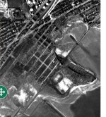
By 1950, just 12 years and over 2 square miles of landfill later, aerial imagry shows a sight already recognizable as Logan International airport, with all but one of its current runways havimg been built. This was the end of the street grid planned for East Boston; the initial construction of Logan required next to no land takings. The Neptune grid just never filled in; at the outbreak of war, few lots were occupied.
View attachment 6743
Even so, until the 1960s, it was still possible to build a grid north from Neptune; indeed, the siting of 1952 built Wood Island seems intended to provide a center piece to this area. Yet, as a result, Neptune was severed at the track crossing from Day Square, sealing it's fate. Ultimately, this area wouldn't be filled in until the 1970s, by which time the area had become fully swallowed by Logan. The few residential buildings ever built, and Olmsted's park, were soon demolished to make way for aviation support facilities and a runway extension.
View attachment 6742View attachment 6744
In the 21st century, all that remains of Olmsted's vision is the oddly disconnected grid of Frankfort and Swift terrace, and the stub of Neptune Road, which remains, to this day, a fully accessible public road, a beautiful boulevard to nowhere.
 

Attachments

  • 1000042021.jpg
    1000042021.jpg
    804.1 KB · Views: 49
Last edited:

Back
Top