Logan Airport Capital Projects

Logan Express says the Framingham parking lot has reopened.

The last time I had gone by it, it didn't look like they were close to being done... but I'll guess the contract with the Mall requires them to be gone by Black Friday. They might be rushing a little bit.
 
The biggest difference here historically is really that the construction of logan didn't resultnin mass evictions or urban destruction in quite the same way, largely because it never was fully built out. As a result, displacements were much more limited. I've posted about it before in a now defunct thread, but up until ww2, Olmsteads grid just never materialized or filled in.
View attachment 68281
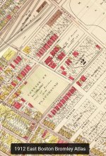
The above may have been the 1860 vision, but it just never fully built out. In the 1922 Bromley Atlas, when Logan was mostly a dream, most of those parcels are shown as white, unfilled, unbought, and the same applies to Eastie proper. Its worth remembering that everything north of Maverick and East of Bremen (including the old B&A yard that is now the Bremen St buffer park) used to be salt marsh that was only filled in the 1920s - much of it was never developed as anything other than Logan. While the segment around Neptune is terra firma, it too remained largely vacant / unsold through 1940 and the outbreak of WW2.
View attachment 68285
View attachment 68286
View attachment 68287
View attachment 68289
The inital 1920s construction of Logan required next to no land takings, as takings were of future fill parcels and new fill, so the street grid of Eastie today is basically as it stood in 1945 - by 1950, the modern shape of Logan is already evident, as are the modern contours of eastie. The Neptune blocks at this time still hadn't built out. The ~1947-1952 construction of the Revere Extension's RoW and Wood Island Station hollowed out the grid somewhat, and despite the new transit connection no more of the grid would ever be built out. The approximately 50 triple deckers then remaining would linger through 1978, when aerials show them being individually demolished, along with the pocket on Frankfort - which, incidentally, was meant to be contiguous to Maverick. I don't know if these were seizures or voluntary sales, but it occurred on a much smaller scale than the downtown urban renewals.

View attachment 68288
View attachment 68290View attachment 68291View attachment 68292
And on that note, I do think we need to accept that Eminent Domain as a power has the potential to do a lot of good, as long as its used surgically, deliberately - its inevitable for infrastructure projects. Without getting into the debate about what's good vs bad infrastructure, like highways, sometimes that means folks gets displaced, because its not viable to keep everything on existing properties. Even today, despite local opposition, we'd probably have supported the 1947 demolitions to create the Revere RoW, and see Baltimore and the controversial takings for the Frederick Douglass Tunnel which most transit and infrastructure folks agree is sorely needed. But there's a difference in building necessary public infrastructure as compared to urban renewal or to advance private development. Getting the Blue Line to Lynn is certain to need eminent domain, but redeveloping Everett doesn't - Theres a reason Kelo v. City of New London is a landmark supreme court case. Notably, MA is one of 5 states that hasn't adopted post-Kelo reforms to eminent domain.
Awesome write up, I was going to ask equilibria what he meant by that area was going to be east bostons answer to back bay, but you ended up showing it. I had never heard about that before.
 
Awesome write up, I was going to ask equilibria what he meant by that area was going to be east bostons answer to back bay, but you ended up showing it. I had never heard about that before.
Yea from the top down it very much looks like an urban renewal bulldozer job, but the history is much more that for whatever reasons economic or social, that plans here just never were completed or progressed very far. The City has maps that show those proposed east boston fill blocks since at least 1844. Even looking at Olmsteds 1880s plan for wood island park, you can see that he thought fill and the grid would extend both north and south of Wood Island, such that it would lose its prominence from the coast line. Despite such grand ambitions, even the terra firma developable parcels surrounding Neptune remained largely unbuilt upon for decades and decades. I haven't looked into the sociology of it yet, but either was sequenced after the back bay land making effort (which only wrapped up in the fens in ~1900), or as a poorer neighborhood of recent immigrants it just didn't get the same investment the Back Bay did. which itself only wrapped up in the fens around 1900. By the 1910s, they'd only just started on the blocks bounded by Bremen, Geneva and Porter, plus the Neptune skeleton - and thats all they really managed through the 40s. For whatever reason, in the nearly century long span between 1844 and the 1940s, no one really wanted to fill it in until the airport came along and did it.
1000042068.jpg
1000042067.jpg
1000042065.jpg
1000042062.jpg
 

Attachments

  • Screenshot_20251104_154549_Chrome.jpg
    Screenshot_20251104_154549_Chrome.jpg
    885.8 KB · Views: 52
Last edited:
These last few posts have had a great little historical rundown of the area; thanks all for it. This got me going down a bit of a rabbit hole about that big stretch of mostly-vacant land to the northwest of Wood Island Park (between Neptune Road and Prescott Street) shown in the second pic in Stlin's post. It had clearly been built out as a neighborhood complete with a street grid, but very little was ever built on it aside from along Neptune Road.


Apparently the East Boston Company had decided to build out that area in 1887. New lands here would have been of questionable value at the time, since they would have been cut off from the rest of East Boston by the Boston & Albany tracks running parallel to Bremen Street (seen at the left edge of the above pic) which were at grade and formed what was described as a dangerous "Chinese wall" of separation. Even so, by 1893 the EBC had filled and graded forty acres, and that same year the Street Commissioners authorized the opening of the street grid between Parkway (aka Neptune Road) and Prescott Street. According to Nancy Seasholes (who calls this area "The Parkway Lands"), the EBC's plan was to sell lots here as part of a new desirable residential neighborhood but this was derailed by the city, which failed to provide sewer access to the area for several years and consequently refused to accept the new streets. Sewer capacity was eventually extended in the 1900s and the EBC finally sold the lands by 1913, but even after this very little vertical construction took place.

After that the trail got sort of spotty. I don't have a clear answer for why this area was never developed even after it gained utilities, other than the usual answers of Great Depression and the decline of Boston in the following decades. In the 1940s the state annexed several significant plots of land in preparation for the airport's expansion, including "several parcels of vacant land and flats lying between Maverick Street and Prescott Street and between the New York, New Haven and Hartford Railroad property and the Airport" in 1944, and "flats belonging to the Boston Port Development Company (which had acquired many of the EBC's assets) lying northerly of World War Memorial Park (aka Wood Island Park) and Neptune Road and extending along the northerly shore-of East Boston toward Belle Isle Inlet" in 1945, but I can't tell for sure if either of these takings included the area in question. Wood Island Park itself was slated to be taken for the airport by the mid-1940s, though it was only cleared in 1967. The street grid for the area still existed (at least on maps) in 1950, but by 1954 the majority of it had disappeared.

As for the EBC, it actually had claim to the East Boston Flats in the 1890s and planned to build out a massive complex of docks in the area, but the state stepped in and seized a huge chunk through eminent domain in 1898 and 1913 for public use instead. Seasholes says the company went out of business in 1928, but the name at least seemed to survive for many years thereafter. In the late 1920s and 1930s the company appears in litigation after it fell delinquent on its property taxes. It later became associated with Bernard Goldfine, who became its largest shareholder. Goldfine was later infamously caught buying federal influence during the Eisenhower administration and eventually went to prison for tax evasion. These are only fragments of a picture though. There's supposedly a bunch of EBC annual reports hanging around somewhere, but frustratingly I couldn't find them online or even a library where they'd be at.

Anyway, thought it was interesting to delve into how such a large piece of land managed to sit vacant for half a century. If anyone has more details about it or about the late history of the EBC I'd be curious.

As evidenced, this is a longstanding pending personal research project of mine, I see you've already cited Seasholes, but these are some primary sources I found particularly helpful.

As requested, East Boston Company Annual Report, 1860 Links to Gale, which also has a couple more years and other interesting documents - If you don't have an academic affiliation, BPL has a public access link here, and they likely have a physical copy in archives, just not cataloged.
A History of East Boston, with Biographical Sketches of its early proprietors, and an Appendix, 1858
East Boston: a survey and a comprehensive plan, City of Boston Planning Board 1915
^edit to add: the 1915 comphrensive and park plans.
eastbostonsurvey00bost_0095 (1).jpg
eastbostonsurvey00bost_0103.jpg

eastbostonsurvey00bost_0006 (1).jpg

A topographical and historical description of Boston, City Council, 1871
Maps of RH Eddy, 1812-1887
Boston 200, Neighborhood Series, 1976 East Boston Profile
 
Last edited:
November Board deck is up: https://www.massport.com/sites/default/files/2025-12/Website-November-Board-Meeting-11.20.25.pdf

Wow, is this a poorly-conceived aesthetic choice. Should have just done a plain parking garage - this building looks like it has a skin disease.

1765994925449.png


Also some takeaways from their Strategic Plan:

- Ground transportation needs "major intervention" but first option is remote terminals. Study Blue Line access options, but no explicit mention of a people mover.
- Major renovation or replacement of the control tower. Good luck with selling a replacement - it's as big an icon for Boston as the Pru or Custom House Tower.
- "AI-enabled gate allocation"
-"Re-imagined Terminal B/C core". Not sure exactly what that entails, but the problem with B/C isn't anything core, IMO, it's the piers.
 
November Board deck is up: https://www.massport.com/sites/default/files/2025-12/Website-November-Board-Meeting-11.20.25.pdf

Wow, is this a poorly-conceived aesthetic choice. Should have just done a plain parking garage - this building looks like it has a skin disease.

View attachment 69394

Also some takeaways from their Strategic Plan:

- Ground transportation needs "major intervention" but first option is remote terminals. Study Blue Line access options, but no explicit mention of a people mover.
- Major renovation or replacement of the control tower. Good luck with selling a replacement - it's as big an icon for Boston as the Pru or Custom House Tower.
- "AI-enabled gate allocation"
-"Re-imagined Terminal B/C core". Not sure exactly what that entails, but the problem with B/C isn't anything core, IMO, it's the piers.
Did they run a contest to see who could make a (usually pretty ugly) parking garage even uglier?
 
What the hell are they teaching architects these days? Its crazy that people are actually getting paid for this crap.
 
  • Like
Reactions: W-4
- Major renovation or replacement of the control tower. Good luck with selling a replacement - it's as big an icon for Boston as the Pru or Custom House Tower.

Although it’s certainly iconic I think most people also understand that this kind of structure has a finite lifespan and this particular one is probably well past its sell-by date.
 
November Board deck is up: https://www.massport.com/sites/default/files/2025-12/Website-November-Board-Meeting-11.20.25.pdf

Wow, is this a poorly-conceived aesthetic choice. Should have just done a plain parking garage - this building looks like it has a skin disease.

View attachment 69394
At least In this case it serves a purpose - those are PV panels, one of the first & biggest solar facades in the US. Even those red panels are solar, which apparently supplies 53% of this buildings power needs. I imagine this is a proof of concept in the US, but that would be really interesting for 5 over 1s clad in with similar non-solar cladding systems.
 
At least In this case it serves a purpose - those are PV panels, one of the first & biggest solar facades in the US. Even those red panels are solar, which apparently supplies 53% of this buildings power needs. I imagine this is a proof of concept in the US, but that would be really interesting for 5 over 1s clad in with similar non-solar cladding systems.
That’s very interesting, although I struggle to envision a scenario where facade solar would be more efficient than rooftop. It might make sense in a situation where rooftop solar is not viable, like a 5 over 1 that wants a roof deck, but that is not the case with parking garages.
 
That’s very interesting, although I struggle to envision a scenario where facade solar would be more efficient than rooftop. It might make sense in a situation where rooftop solar is not viable, like a 5 over 1 that wants a roof deck, but that is not the case with parking garages.
I don't think its a straight efficiency problem - I suspect that these are actually less efficient than a general purpose rooftop panel per area, but solar is all about lit surface area. I think the general theory is that most building massing is some form of rectalinear prism with 6 faces, and if we assume the building is cuboid, the face resting on the foundation is clearly out, but 4/5 remaining faces are vertical, and actually accounts for a majority of building surface, and lit, area. We know already this is a concern with windows and solar heating - That surface area to roof ratio is worse for short and squat buildings like a parking garage or a factory with expansive roof space, but the opposite is true of say a skyscraper or lab structure with a rooftop mostly occupied by mechanical structures.

I believe solar facades are just to make those vertical surfaces more viable for PV generation. They've done it before with more traditional general purpose PV panels (Green Dot Animo Leadership High School, FKI Tower Seoul, this building in Cambridge), but not every building or community is willing to see it. I think this is an architectural product meant to replace / supplement traditional cladding materials on buildings that might not want to make the solar quite so obvious - the pitch is clearly "invisible solar" - PV glass is already a thing for all-glass hung facades, but I think this is meant as a substitute for those buildings that would otherwise get aluminum or composite panel cladding systems. Looking at some of that company's other projects, you wouldn't know that those metallic/cementious facade panels were in fact solar panels, at the cost of relative efficiency.
 

Attachments

  • Red-River-College-exterior-7.jpg
    Red-River-College-exterior-7.jpg
    337.2 KB · Views: 30
  • c678f8c4b57c98e52a18b6815f7e82cc0bd1d0b1-4032x3024.jpg
    c678f8c4b57c98e52a18b6815f7e82cc0bd1d0b1-4032x3024.jpg
    221.8 KB · Views: 36
  • 382761ef0801d3a44529118cf63141b134e2d018-4911x3274.jpg
    382761ef0801d3a44529118cf63141b134e2d018-4911x3274.jpg
    125 KB · Views: 27
  • d95c178edf820404fa0377d23a28f2cdd9ddfba0-5472x3648.jpg
    d95c178edf820404fa0377d23a28f2cdd9ddfba0-5472x3648.jpg
    160 KB · Views: 29
Last edited:
Although it’s certainly iconic I think most people also understand that this kind of structure has a finite lifespan and this particular one is probably well past its sell-by date.
I wouldn't say that the structure has a lifespan - the technology in the cab does. Unless there are serious accessibility or safety concerns the tower is presumably structurally fit - it's just a concrete tower. The replacement issue is more that they would need some magical interim tower if they were going to replace the cab without shutting the airport down for months.

Not happening under our current regulatory scheme, but I wonder if that wouldn't be a good application for a Remote and Virtual Tower https://en.wikipedia.org/wiki/Remote_and_virtual_tower.
Concrete structures certainly have lifespans, especially since the codes have changed significantly since the tower was built c.1971. Retrofitting the structure to bring it to up-to-date codes can often be complex and cost intensive, especially for a cast-in-place concrete tower such as that one.

The biggest issue for a new tower is phasing and keeping one active at all times. That may involve building a temporary tower if the new one needs to be in the same spot as the current one, for instance. A virtual tower is interesting but agree with the fact that we’re probably not ready for that tech at an airport as busy as Logan.
Good example of the design life of a cast in place concrete tower is the Eastgate Tower formerly in Kendall Square. Eastgate was even younger than the Logan Control Tower (circa 1966), but the evaluation of the retrofit and upgrade costs versus replacement led to its demolition and replacement with the SoMa complex.

One unfortunate design aspect for many cast in place concrete buildings from that era was the practice to embed building systems in limited access raceways within the concrete (preserving the smooth concrete finish). This makes access for upgrades a total nightmare.
 
Last edited:
They've done it before with more traditional general purpose PV panels (Green Dot Animo Leadership High School, FKI Tower Seoul, this building in Cambridge), but not every building or community is willing to see it. I think this is an architectural product meant to replace / supplement traditional cladding materials on buildings that might not want to make the solar quite so obvious - the pitch is clearly "invisible solar" - PV glass is already a thing for all-glass hung facades, but I think this is meant as a substitute for those buildings that would otherwise get aluminum or composite panel cladding systems.

I don't want to sound too snarky, because this is super helpful background and really interesting from the pure technology side, but the problem for me is that thing in Framingham looks one million times uglier and more visible than just throwing some PV on it and calling it a day. I honestly thought that was a low-res rendering with some dashes of impressionistic cladding for effect. Really wild that's what was settled on as the final form when those same panels could have just been put in orderly rows. Anyways, it's not too important but pretty crazy to me this was the final decision.
 
The tower is iconic, but honestly - it's dated.

The brown metal panels are a relic of a an anachronistic architectural style and when they removed the walkway that connected it to the old terminal D building years ago, it just reinforced the need to address the structure sooner rather than later.
 
The tower is iconic, but honestly - it's dated.

The brown metal panels are a relic of a an anachronistic architectural style and when they removed the walkway that connected it to the old terminal D building years ago, it just reinforced the need to address the structure sooner rather than later.
I would say a new tower would be more likely to to be cookie-cutter than iconic, but apparently that's no longer the case in 2025...


Does still beg the question of where you put it - they can't use the same location if the current tower would operate through construction. Maybe on the cell phone lot or some other small parking lot near Terminal E? Build it into an expansion/renovation of the Massport office building on Harborside Drive (it will be 30+ years old by the time they do this)?
 
Last edited:
Err, as for the tower I would point out that it got a $12M Fed grant towards a $20M phase 1 modernization & expansion in early 2024, which clearly anticipates a phase 2 renovation of the whole tower. Its running behind, but the last time I was at logan its fairly obvious that they've started on those new 4 lower levels. Once thats complete, those will relocate functions from the upper floors, allowing for modernization - for the foreseeable future, the current tower v is largely likely here to stay.
1000033516 (1).jpg
 
Despite the fact that the proposed Framingham Logan Express remote terminal hasn't even started its pilot operation yet, Massport has released a RFQ for a CMAR to build a $400m garage and remote terminal for Braintree Logan Express - highlights are 5025 structured spaces replacing 1875 surface spaces, and a terminal structure incorporating a TSA checkpoint and secure bus boarding.
1000042762.jpg
1000042759.jpg
1000042756.jpg
1000042765.jpg
 

Attachments

  • 1000042770.jpg
    1000042770.jpg
    213.3 KB · Views: 23

Back
Top