You are using an out of date browser. It may not display this or other websites correctly.
You should upgrade or use an alternative browser.
You should upgrade or use an alternative browser.
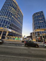
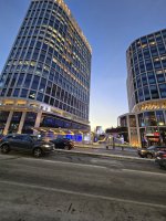
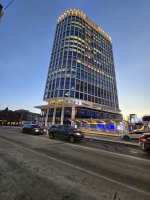
Lyrik Back Bay | 1001 Boylston Street (Parcel 12) | Back Bay
- Thread starter Equilibria
- Start date
#bancars
Senior Member
- Joined
- Jun 1, 2019
- Messages
- 1,658
- Reaction score
- 6,694
Bike safety experience on this stretch is night and day now. Used to feel like taking your life in your hands, mixed traffic, on Mass Ave, and competing with cars revving up to turn onto a highway onramp.
It's definitely better, but the intersection treatment at Newbury & Mass leaves a lot to be desired. The rumblestrips they have on the ground by the corner on each side of the crosswalk don't seem to deter drivers at all--nearly everyone turning onto the highway just runs right over them, usually at an aggressive speed (with regular red-light running after bikes have the green signal). If the purpose is to get drivers to slow down and make 90-degree turns then the design is failing completely.
The Boylston & Mass intersection is a little better as it actually has two protected corners, but still could be better. The placement of the BlueBike station adjacent to the bus stop funnels a ton of pedestrians straight into the cycletrack causing more conflict than is necessary I think.
I was gonna add to my post, but for once decided to not add the pessimism, that the northbound leg of Mass here still needs some treatment. I do think overall, because of the narrowing of Boylston, and the protected lanes on most of Mass, it presents a more "take it seriously" driving feeling all around here and has made things better. But I agree with you—even the southbound lane of Mass needs something more. I think the psychology of driving is often missed in planning and the psychology of the driver when their mindspace is, "I am about to turn onto an interstate highway onramp" inevitably is loading their mind with cues to speed up and get ready to floor it. Coupled with the fact that when I am biking, I intuitively assume that anywhere near a highway entrance or offramp is likely to have drivers from out of town (ie, danger). So even more is needed here. But likewise, the overall "feeling" of driving around here is wayyyy more constricted, more squashed, more flex posts, more painted lanes, and that tends to make people slow down even just by dint of being anxiety provoking. Scare the driver!It's definitely better, but the intersection treatment at Newbury & Mass leaves a lot to be desired. The rumblestrips they have on the ground by the corner on each side of the crosswalk don't seem to deter drivers at all--nearly everyone turning onto the highway just runs right over them, usually at an aggressive speed (with regular red-light running after bikes have the green signal). If the purpose is to get drivers to slow down and make 90-degree turns then the design is failing completely.

How do you build a skyscraper over a highway? Developer Steve Samuels found out. - The Boston Globe
The developer of the first "air-rights" construction project over the Massachusetts Turnpike in decades talks about his vision for stitching the city together.
Give him Parcels 13 and 14! Give him whatever he wants!
How do you build a skyscraper over a highway? Developer Steve Samuels found out. - The Boston Globe
The developer of the first "air-rights" construction project over the Massachusetts Turnpike in decades talks about his vision for stitching the city together.www.bostonglobe.com
View attachment 58919
themissinglink
Senior Member
- Joined
- Jan 13, 2018
- Messages
- 1,498
- Reaction score
- 3,814
I wish.Give him Parcels 13 and 14! Give him whatever he wants!
This is what he said about his involvement in future air rights:
Having played the long game in bringing this building to life, Samuels isn’t breaking ground on a new air rights project again anytime soon. And the city is a far different place today than when he started, with both office work and the retail landscape still adjusting to the long-term impact of the pandemic. But Samuels says he’s bullish on Boston, and on the city’s ability to reimagine itself in the years ahead.
JeffDowntown
Senior Member
- Joined
- May 28, 2007
- Messages
- 4,795
- Reaction score
- 3,660
Noted a curious feature near to the project in this photo. What is up with the new looking stairs coming down from Ipswich Street and the apparent grade crossing of the train tracks; southwest edge of the project area (upper right in image)?
How do you build a skyscraper over a highway? Developer Steve Samuels found out. - The Boston Globe
The developer of the first "air-rights" construction project over the Massachusetts Turnpike in decades talks about his vision for stitching the city together.www.bostonglobe.com
View attachment 58919
Equilibria
Senior Member
- Joined
- May 6, 2007
- Messages
- 7,085
- Reaction score
- 8,316
Access to build the columns between the tracks and the road with the Pike open?Noted a curious feature near to the project in this photo. What is up with the new looking stairs coming down from Ipswich Street and the apparent grade crossing of the train tracks; southwest edge of the project area (upper right in image)?
JeffDowntown
Senior Member
- Joined
- May 28, 2007
- Messages
- 4,795
- Reaction score
- 3,660
I thought that, but the stairs don't seem to be very useful construction access. The grade crossing makes some sense, although access other than the stairs is not apparent.Access to build the columns between the tracks and the road with the Pike open?
FWIW, there's a bunch of old access infrastructure near old Charlesgate park right around here.Noted a curious feature near to the project in this photo. What is up with the new looking stairs coming down from Ipswich Street and the apparent grade crossing of the train tracks; southwest edge of the project area (upper right in image)?
cubbe8
Active Member
- Joined
- Mar 18, 2022
- Messages
- 330
- Reaction score
- 563
New truck pad?Noted a curious feature near to the project in this photo. What is up with the new looking stairs coming down from Ipswich Street and the apparent grade crossing of the train tracks; southwest edge of the project area (upper right in image)?
That would be my guess - looks like the stairs and controlled entry gate were updated recently but the truck pad entrance has a Keolis sign on Google Street View in October 2023..New truck pad?
AndrewOnTheMBTA
Active Member
- Joined
- Mar 12, 2021
- Messages
- 322
- Reaction score
- 629
AndrewOnTheMBTA
Active Member
- Joined
- Mar 12, 2021
- Messages
- 322
- Reaction score
- 629
Smuttynose
Active Member
- Joined
- May 26, 2006
- Messages
- 686
- Reaction score
- 3,728
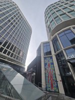
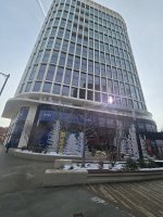
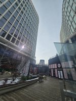
The snow machines are a nice touch; the snow is very realistic. I actually thought the storm started early before I caught on —


