Massachusetts Turnpike/I-90 (Current Projects, Conceptual Improvements, & Long Term)

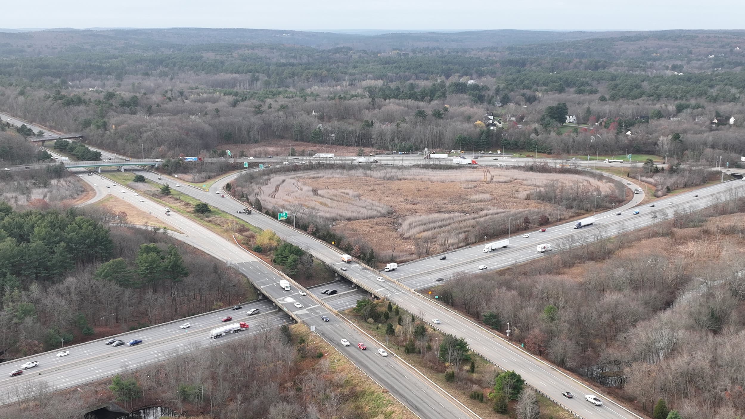
One area of the Mass Pike that seems to be getting worse and worse is the Exit 90 interchange with I-290 & I-395. Specifically there always seems to be traffic on I-90 Westbound at Exit 90 and at the merging onramp traffic from I-290/I-395. The other issue is that I-290 Westbound traffic gets stuck queuing in the right lane to get on to I-90 at exit 12 for 1-2 miles at times. Does anyone know if MassDOT is eyeing this area for traffic studies or improvements?
1728059477279.png

The other ridiculous aspect of this messy interchange is that traffic coming up I-395 Northbound to get onto I-90 has to get off the highway and merge onto Route 12 in Auburn before jumping on the I-90 on ramp to head I-90 Eastbound/Westbound. This is crazy to me and Route 12 in the summer can get really backed up because there is a light right before the onramp. This design is horrific and I wonder if it would ever be changed? See my markups in red and dont mind the horrible line tracing I attempted lol. This area is very constrained by neighborhoods and businesses.
1728059661248.png
 
This area is very constrained by neighborhoods and businesses.
It's also tightly constrained by rock cliffs around the actual ramps of the trumpet interchange. The Pike mainline is blasted through a cut in that vicinity.

I'm honestly at a loss to describe how this interchange can be significantly improved given all the constraints on every side. And the state's never studied anything here, so I think they've reached the same conclusion.
 
I *believe* the last studies of this area were in the late 90s to early 2000s when they were trying to build an access road to Worcester Airport - I don't think it's accessible online, but reporting from the time seems to suggest that MassHighway would have considered reconfiguring the RT12 ramps for airport access from I90/290.
 
The crash occurred at the Beacon Street overpass, according to Massachusetts State Police. A Nissan Pathfinder SUV entered the work zone that was set up in the center and right lanes, striking an elevator scissor lift. Both workers were transported by Boston EMS ambulances to local hospitals with serious injuries.
 
Here's my concept to redo the Auburn interchange. I believe it's doable, and would open up some land for development:

1728188095570.png

For comparison, this is an aerial of the current interchange:
1728188651808.png
 
Last edited:
The virtual public meeting for the Newton Corner long-term study just started a few minutes ago.
The first public info meeting for the Long-Term Study is Tuesday, October 8, 2024, at 6:30pm on Zoom. Please register to obtain the Zoom link.
 
Last edited:
I *believe* the last studies of this area were in the late 90s to early 2000s when they were trying to build an access road to Worcester Airport - I don't think it's accessible online, but reporting from the time seems to suggest that MassHighway would have considered reconfiguring the RT12 ramps for airport access from I90/290.
If you remember the website you can try www.archive.org and see if you can find it via the internet archiver. Or it might be on www.archive.is
I also don't know if you can find the actual studies. I've tried to look for these types of things before too.

I'm unfamiliar with the state prior to moving here in ~2007 but from my quick rabbit hole dive you might be able to find some more "official" references to it on the State Library of Massachusetts digital collection (which seems like a very cool repository of information. I personally plan on doing some fun reading of Regional transportation plan 2004-2025 of the Boston region MPO from late 2003)

From that digital collection, maybe finding something like this: Accessing the future: the intermodal transportation plan for the Commonwealth of Massachusetts 1995 (see pdf to download on the left) which makes references to some interchanges in the Worcester region. I don't have time to go further down the rabbit hole, but searching for "turnpike worcester interchange" and limiting between 1990 and 2004 leads to a bunch of results on that digital archive

I clipped some example from my quick search of that 1995 document here:


Screenshot 2024-10-09 at 11.07.36 AM.png


EDIT: Well it looks like you could ask the Worcester Public Library to let you get information from this: Access study for the Worcester Regional Airport, Worcester, Massachusetts : final report.
 
Last edited:
I also don't know if you can find the actual studies. I've tried to look for these types of things before too.

I'm unfamiliar with the state prior to moving here in ~2007 but from my quick rabbit hole dive you might be able to find some more "official" references to it on the State Library of Massachusetts digital collection (which seems like a very cool repository of information. I personally plan on doing some fun reading of Regional transportation plan 2004-2025 of the Boston region MPO from late 2003)

From that digital collection, maybe finding something like this: Accessing the future: the intermodal transportation plan for the Commonwealth of Massachusetts 1995 (see pdf to download on the left) which makes references to some interchanges in the Worcester region. I don't have time to go further down the rabbit hole, but searching for "turnpike worcester interchange" and limiting between 1990 and 2004 leads to a bunch of results on that digital archive

I clipped some example from my quick search of that 1995 document here:


View attachment 56674

EDIT: Well it looks like you could ask the Worcester Public Library to let you get information from this: Access study for the Worcester Regional Airport, Worcester, Massachusetts : final report.
The report is referenced in this 2014 article. TLDR: A direct access road would cut through residential areas and wetlands, would be expensive, take forever to get funding, and built if approved at all.
 
The Federal Highway Administration recently announced that the Massachusetts Department of Transportation was awarded a $1.7 million grant for the bridge. Sixteen wildlife crossing projects nationwide received $125 million in grants from the bipartisan infrastructure law signed by President Joe Biden in 2021.

The new bridge "will offer separate and distinct areas for wildlife, pedestrians and hikers and include fencing to help funnel wildlife to the crossings," the administration said.
 
According to the Boston Globe, Chick-fil-A has been denied a bid to operate at MassPike rest stops because of a conflict over hours. The company was originally founded by a devout Southern Baptist whose business practices were "based on biblical principles"
[...]
Because of these principles, the chicken chain has long closed each location on Sunday, a traditionally religious day of rest. This is where the Massachusetts DOT takes issue. The MassDOT requires all state rest stops to be open seven days a week. According to the Globe, "the new language was written so that travelers don’t go hungry when looking for a place to eat along the pike."
 

Back
Top