MBTA Commuter Rail (Operations, Keolis, & Short Term)

I'm sure it could be improved, but the fact that you marked Readville as a terminus at all is such an improvement.
The issue is with the Franklin Line. The way I have it now is slightly a lie, as it shows Franklin->Fairmount trains stopping at the Franklin Line platform at Readville rather than the Fairmount Line platform. Doing it the other way made it look too much like Readville was a short turn, not the terminus that it usually is, and so I opted to do it this way, but I do wish I could find a way to have it be fully accurate and also clear that Readville is generally a terminus.
 
I'm still not happy with the fare zones, I'll need to mess around with them some more. Also they haven't published what fare zones the SCR stations will be in, so I need to wait for that. I'm at least mostly satisfied with the rest of the map, with the slight exception of Readville. A few other people are also really annoyed about the Wildcat being omitted but I'm holding firm on that.
To me, the biggest issue with readability of fare zones on your current map is Franklin Line. One possibility is to replicate another 1-10 scale to the southwest between Franklin and Needham. Or you can perhaps flatten out Franklin Line in the east-west direction, making Dedham Corporate Center due west, before turning southwest at Islington.
 
Official CR Map with SCR at Ruggles
View attachment 48890
My thoughts:
  • Why on earth would you show SCR like that that's horrendous
  • Why is Plymouth back?
  • The * for "Temporarily suspended" stations is helpful at least.
  • Is that a double space on MATTAPAN LINE? It sure looks like it.
  • CapeFlyer isn't a CR service, why is it shown in purple?
  • They've changed the GL branches to look a lot more like how I did them, I approve.
  • Why is the Wildcat Branch so blocky and ugly?
  • The "Middleborough Line" text suggests there will be short turns? That would be really bad for Fall River/New Bedford frequencies. Hopefully it's just there to hold them over until service starts?
  • Readville still sucks
Something else I just noticed: the station at the end of the Franklin Line is labeled "Forge Park/Route 495", despite being signed everywhere else (on the T's website, on the schedule, and on the platform) as "Forge Park/495" (omitting the "Route").
 
Something else I just noticed: the station at the end of the Franklin Line is labeled "Forge Park/Route 495", despite being signed everywhere else (on the T's website, on the schedule, and on the platform) as "Forge Park/495" (omitting the "Route").
Which is not consistent with Littleton/Route 495, which is signed as such on all the maps and station signs. sigh. This is an excellent representation of what makes trying to show all the services accurately so immensely frustrating.
 
I just noticed another VERY small area for improvement. The Hingham ferry terminal is shown on the bay between E. Weymouth and W. Hingham. In actuality, I believe it would be located on the bay between W. Hingham and Nantasket Jct. Looking on the Google Map, I can see where the ferry terminal might be to the West of W. Hingham, but it just doesn't feel correct to me.

1711204268765.png
 
I just noticed another VERY small area for improvement. The Hingham ferry terminal is shown on the bay between E. Weymouth and W. Hingham. In actuality, I believe it would be located on the bay between W. Hingham and Nantasket Jct. Looking on the Google Map, I can see where the ferry terminal might be to the West of W. Hingham, but it just doesn't feel correct to me.

View attachment 48903
Looking at it on Google Maps it looks to actually be further west than it's shown on the map, not further east.
 
Something else I just noticed: the station at the end of the Franklin Line is labeled "Forge Park/Route 495", despite being signed everywhere else (on the T's website, on the schedule, and on the platform) as "Forge Park/495" (omitting the "Route").
Biggest *oof*: the "Providence/Stoughton Line" label being moved below Canton Jct. On v. 37 of the map the label straddled the line split so made sense. Now it makes no sense whatsoever being alongside the Providence-exclusive portion of NEC.
 
Biggest *oof*: the "Providence/Stoughton Line" label being moved below Canton Jct. On v. 37 of the map the label straddled the line split so made sense. Now it makes no sense whatsoever being alongside the Providence-exclusive portion of NEC.
They have at least made the Stoughton branch longer, which I agree with. The v.37 map version looks way too stubby. Now fix the OL looking incredibly bendy and stupid.
 
Official CR Map with SCR at Ruggles
View attachment 48890
My thoughts:
  • Why on earth would you show SCR like that that's horrendous
  • Why is Plymouth back?
  • The * for "Temporarily suspended" stations is helpful at least.
  • Is that a double space on MATTAPAN LINE? It sure looks like it.
  • CapeFlyer isn't a CR service, why is it shown in purple?
  • They've changed the GL branches to look a lot more like how I did them, I approve.
  • Why is the Wildcat Branch so blocky and ugly?
  • The "Middleborough Line" text suggests there will be short turns? That would be really bad for Fall River/New Bedford frequencies. Hopefully it's just there to hold them over until service starts?
  • Readville still sucks

My thoughts:
  • I don't have a strong feeling on whether the CapeFlyer is shown in purple or another color to distinguish it from year-round commuter rail -- just as long as it's finally shown on the MBTA system map. It's long past time.
  • The CapeFlyer service east of Middleborough should be labeled by it's name "CapeFlyer" and not just "Hyannis (seasonal)."
  • The CapeFlyer will not be using the new Middleborough station -- it should be depicted as branching off north of the station.
  • I'm split of the depiction of the routing shown for SCR phase 1 below Middleborough. Bad marketing, but "truth in advertising" also comes to mind regarding the crappy routing of this service. I think the Foxboro depiction is worse, suggesting trains backtrack when it's "only" a ~90-degree off the Forge Park route.
 
  • I don't have a strong feeling on whether the CapeFlyer is shown in purple or another color to distinguish it from year-round commuter rail -- just as long as it's finally shown on the MBTA system map. It's long past time.
Keeping it the same color as the rest of the system is logical because it's a thru route that begins in Boston and not a separate shuttle route. Different color can give the mistaken impression that you have to change trains en route.
 
To me, the biggest issue with readability of fare zones on your current map is Franklin Line. One possibility is to replicate another 1-10 scale to the southwest between Franklin and Needham. Or you can perhaps flatten out Franklin Line in the east-west direction, making Dedham Corporate Center due west, before turning southwest at Islington.
Experimenting a bit with some version of this idea, also took the opportunity to improve Readville Accuracy™ a bit more.
1711324588421.png
 
^ Huh, I guess that’s true — the one Fairmount train that continues on to the NEC (to Stoughton, IIRC) doesn’t actually stop at Readville, does it?
 
https://www.bostonglobe.com/2024/03...-could-be-coming-to-ts-commuter-rail-in-2027/

TL;DR:

--exasperatingly, the MBTA has been foot-dragging for years in terms of living up to its previously announced timelines of when it would electrify its CR fleet
--embarrassingly, the MBTA is the last major transit agency to electrify its CR fleet
--puzzlingly (disturbingly?), the MBTA is a pronounced outlier in committing to battery electric trains vs. overheard wire trains

Other than that, it's all so very joyous and exciting because this *might* be implemented in

(checks notes)

. . . 2027.
Has Eng chimed in on this at all? I would think given his background running an actual electrified (and diesel) commuter rail system he would be more of a voice of reason against the insanity of a full battery build out. Why can't we get something like the M9s on the LIRR/Metro North and start stringing up catenary wire.
 
Last edited:
^ Huh, I guess that’s true — the one Fairmount train that continues on to the NEC (to Stoughton, IIRC) doesn’t actually stop at Readville, does it?
No, the curve of track connecting the NEC to Fairmount bypasses Readville completely.
 
Experimenting a bit with some version of this idea, also took the opportunity to improve Readville Accuracy™ a bit more.View attachment 48937
1711366964062.png

Mostly finished the rework of this part of the Franklin Line based @Teban54's suggestions along with remaking Readville and Foxboro to be more accurate, I'll finish polishing the zones another time. Every time I look at a section I've already done I find new ways I'm unhappy with it so I'll probably redo the Lowell, Haverhill, and Newburyport/Rockport Lines next since I'm unhappy with how sloppy the zones look.
 
 
LYNN — Moving the River Works commuter rail station a third of a mile north of its present location and making it accessible to the public is a big part of a new vision for public transportation in West Lynn.

In recent weeks, it was announced that the city had received $561,000 through the U.S. Department of Transportation’s Reconnecting Communities and Neighborhoods (RCN) Grant Program to reimagine the city’s public transportation system. The money is part of $3.3 billion in grant awards for 132 communities.

As part of the city’s first comprehensive plan, Vision Lynn, Mayor Jared Nicholson said the city will be using the federal funds towards Lynn’s River Works Reimagined Community planning study. The study will be used to initiate funding, design, and construction of a relocated commuter rail station.

According to a press release from the Mayor’s office, the plan is to relocate the station one-third of a mile north of its current location, making it publicly accessible while reconnecting West Lynn.

The current station is located on Western Avenue, operates on the Newburyport/Rockport line, and serves only employees of General Electric.

“(The idea for a new station) came up in the Transit Action Plan that the city did a couple years ago, and really, for years, folks have seen this stop on the commuter rail and imagined the potential if it were to be open to the public,” Nicholson said.

Nicholson continued, saying that the plan to relocate the station coincides with the region’s larger plan of electrification, which will save residents time, increase reliability, lead to more affordable fares, and provide a “truly regional rail system.”

“We desperately need better access to transportation for all the reasons that people have for getting around. We want to connect our residents with good paying jobs, and they need to be able to access the broader region,” Nicholson said.

He said the improved transportation creates access to education, healthcare, affordable housing, and improves traffic in the city by taking cars off the road.

The ultimate timeline of the planning and the project are not known yet.

“The city has been underserved by transit access for decades, and it’s moments like this that a different future starts to become, starts to feel more attainable,” Nicholson said.
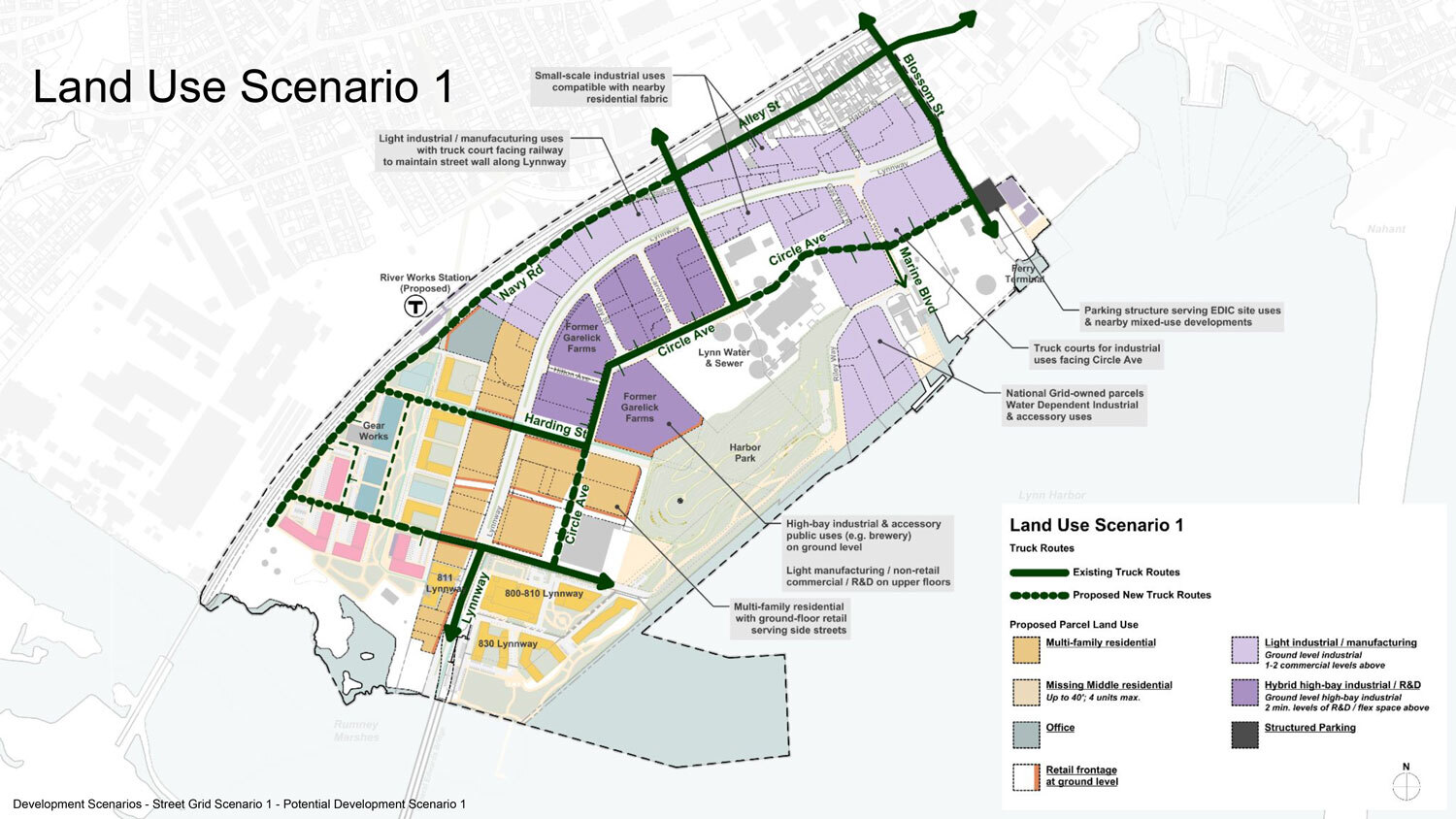
So it sounds like no real plan yet. Electrification sounds like an implicit design requirement/feature here, not sure if Lynn will use the opportunity to push for the Blue Line extension as well. Also, I hope they keep the name. I've seen "Lynnport" floated as the name for a redevelopment/relocated station in the area but that's boring and River Works is a way cooler name.
 
Last edited:

Back
Top