New T Map

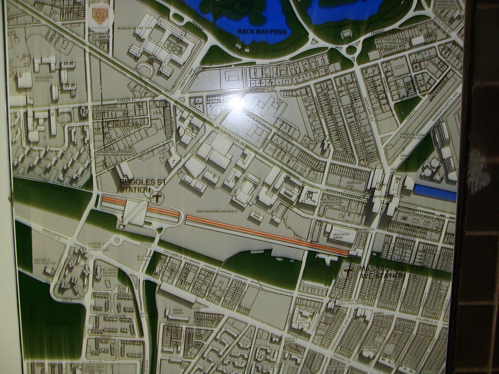
The map replacement project is expected to take two years and cost a total of $500,000 -- including labor and production

Dear Mr. Pesaturo,

If you're reading this, then first of all, congratulations. Unless one of your aides has found this, printed it out, and placed it on your desk next to the morning comics, then I must say that I am pleased and slightly befuddled that you are, in fact, reading it. Even if you are, however, perusing a printed-out version next to your morning comics, then please give my kudos to your thoughtful staff member.

Second, I hope you will hastily register on this website (www.archboston.org if you are reading a print-out) and PM (that means "private message") me. Why should you do this? Because I can personally do this job for you for 1/10th the price - that's $50,000 - and still run to the bank laughing. I'll also do it in about two weeks - or 1/50th the amount of time you've scheduled for this. We'll both feel like we got a great deal. I won't reveal my magical methods, but let's just say, between you and me, that it might involve printing and copying maps and placing them into frames that I can buy at a newflangled low-cost store that rhymes with IPEA. I don't mind getting my hands dirty, and I'm certainly not afraid of breaking my nails, so installing these would not be the immense undertaking that it would be to your staff, whose time is anyway better spent doing the sunny job they do of assisting customers and maintaining your stellar and fail-proof infrastructure. Please consider this proposal. After all, two years from now, the Silver Line will no doubt have expanded to involve all-manner of exciting new rapid transit options, such as taxi rapid transit lines, sidewalk rapid transit lines, and even the exciting new technologies that allow the great city of Boston to install private-autos-on-traffic-choked-highways rapid transit lines. Would you really want to go through your lengthy and expensive method of map-posting again as soon as you've finished? Of course not. That would be foolish.

Yours sincerely,

Shepard
President, Cost-Efficient Competence, Inc.
 
Last edited:
Why not make the maps from LED displays and simply reprogram them every time there is a line change? That would allow for dynamic train locations, schedules, you know USEFUL INFORMATION.
 
Why not make the maps from LED displays and simply reprogram them every time there is a line change? That would allow for dynamic train locations, schedules, you know USEFUL INFORMATION.

Yeah.. while you're at it why not put plasmas in the restrooms too. real DYNAMIC.
 
So....anybody know whether the Washington South Station link will really begin within a month?
 
Amazing what Pesaturo gets away with. I don't think I've ever heard a more arrogant and defensive spokesman in my life. It must be nice to make $100,000 a year to spread lies from the T.

The article leaves out the important question of why will it take 2 years to do this?
 
Yeah.. while you're at it why not put plasmas in the restrooms too. real DYNAMIC.

Plasma costs more than LEDS and has a service life of 3-4 years before failure.

LEDS are durable, can last up to 100 years before failure, and are far more cost efficient. Somehow I think a $1,200 LED map, which lasts half a century of updates and provides dynamic information, eventually would be more cost effective than overpriced paper maps which become outdated with every service change or development.
 
Sorry about the poor quality of this image but....


One of the old MBTA neighborhood maps at Ruggles station. I would imagine this map is from May 1987 when the Orange Line first opened for business. They pretty much seem to show the world as it was when they were posted.

I am going to try to go around and get pictures of as many of these as possible before they are taken down or covered. Maybe others want to help???

http://www.flickr.com/photos/bostoncitywalk/
 
So....anybody know whether the Washington South Station link will really begin within a month?

I just noticed while walking to Chinatown station yesterday that they've painted bus lanes onto at least part of Essex St.

Of course zero enforcement will render them useless. Installation of bus traps along the route would make me giggle with glee.
 
"Bus traps" don't seem very well thought out. As a deterrent they probably work well, but if someone actually gets caught in them, it holds up the bus and costs a lot to deal with.
 
Installation of bus traps along the route would make me giggle with glee.

They would be the delicious bane of livery and cab driver's existence. Sweet sweet justice. Now if those were installed in front of fire hydrants too....
 
"Bus traps" don't seem very well thought out. As a deterrent they probably work well, but if someone actually gets caught in them, it holds up the bus and costs a lot to deal with.

Those little metal bollards that move up and down would be easier. Theyre even found in Boston at the entrance to the SL underground tunnel.
 
I just read over at railroad.net that indeed these maps ARE being printed and placed into existing frames, and put up as stickers in trains (Mr. Pesaturo, my sincere apologies for not giving your organization the benefit of the doubt!)

Still though, and in all seriousness... half a million dollars over two years ... Why is this not taking two weeks and $10,000 or less?
 
I shall miss thee, strangely oriented map

IMG_2944.jpg
 
You want efficiency? This is Boston, not Hitler!
 
"Still though, and in all seriousness... half a million dollars over two years ... Why is this not taking two weeks and $10,000 or less?"

1. Union labor
2. The new maps are being transported via the Green Line and the older RTS busses, we all know that can take awhile.
3. Whoever heard of Kinkos or CafePress? What are these mythical things you speak of?
 
Thank god the MBTA isn't planning my wedding.
 
flzrl0.png

fxqzgp.png


Is anyone able to explain this clusterfuck? Are they actually trying to make it complicated?

"Oh, you need to get to the airport? Take Silver Line 4. Make sure it's not Silver Line 5 or you lose. You'll have to get off at South Station. No, that's not the airport, so don't expect planes. It's a train station. After you get off there you'll have to get back on the Silver Line. It is extremely important that when you get back on you are getting on Silver Line 1. If you get on Silver Line 2 I can't tell you where you'll end up. No one really knows. Just make sure it doesn't happen. Silver Line 1 will take you to the airport."

"...now where is this Silver Line train?"
 
What's the street routing? I'm guessing that it's a problem with street routes, the visual display, or more likely both.

The silver bus should have simply been routed to stop at Chinatown and then take Kneeland/Essex steets to and from South Station.

It certainly doesn't need a direct connection with Boylston (510 feet from Chinatown), and, since it's connecting with the Red Line at South Station anyway, arguably not with DTX either (a more daunting 1200 feet from Boylston in any case).

This surface routing is a bungled mess, and all the worse that it now appears on our half-a-million dollar signage. Yuch.
 

Back
Top